Showing 22371 items matching "parks"
-
 Uniting Church Archives - Synod of Victoria
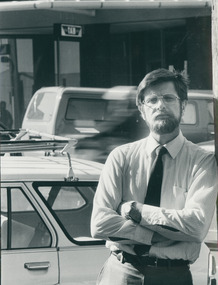
Photograph, Rev. Peter Blackwood blocks off the TAB, 28/09/1986
The Rev. Peter D. Blackwood was ordained in 1977 and his first placement was at Burwood Heights. He has had several placements, including as Presbytery Minister and Associate General Secretary of the Synod. He is now retired. This picture was taken after a church protest in Warrnambool. "Members of the Warrnabool UC walked home from church on Sunday 28 September, in a protest against Sunday racing. The 150-strong congregation left cars parked outside the church, which coincidentally blocked all car spots outside the local TAB. The vehicles were left parked throughout the afternoon, creating an inconvenience for punters wanting to place a quick bet. UC minister, the Rev. Peter Blackwood said the congregation decided on this form of protest after the TAB had ignored objections from the UC that the TAB be open on Sundays…"B & W photograph of Peter Blackwood standing with arms folded, by the door to a TAB at Warrnambool.C&N identificationblackwood, peter d., warrnambool protest, tab on sundays -
 Geelong Football Club
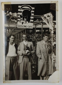
Norm Scott Photograph, Norm Scott GFC
Norm Scott Born: 06/06/1921 From: East Geelong Height: 182cm Weight: 83kg Natural kicking foot: Right Guernsey number: 29 First senior match: Round 5, 1946 v St Kilda at Kardinia Park The hard-working, dashing half-back was a solid performer during the latter half of the 1940s. He was fast, kicked very well and liked to sprint to the ball, gain possession, tear through and create attacking moves from defence. Courage and determination were evident in his play. Total Brownlow Medal votes: 1 Career span: 1946-52 Total matches: Premiership 101 Total goals: Premiership 4 Finals matches: 2 Finals goals: 0 Last senior match: Round 3, 1952 v St Kilda at Kardinia Park Died: 17/02/1957 Small, black and white photograph of three men standing together. The man standing in the middle is Norm Scott and he is holding a small, black toy cat. The three men are standing under a Geelong Cats Mascot banner at the entrance to the race. There is a white border around the photograph. Perhaps the 1951 Finals norm scott, cats -
 Warrnambool and District Historical Society Inc.
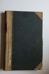
Administrative record - Warrnambool Friendly Societies Park Trust Ledgers, Friendly Societies Park Trust administrative personnel, 1871 to 1947
These ledgers are administrative records of the Warrnambool Friendly Societies Park Trust. One contains Minutes of meetings from 1931 to 1947 and the other is an Accounts Book with records of payments for salaries, insurance, rentals, ground improvements etc. from 1908 to 1947. Some inserts in the ledgers date back to the early days of the Trust. In 1871 the Friendly Societies of Warrnambool (benefit societies which mainly offered members heath cover, including the Oddfellows, Foresters, Hibernians,, Rechabites, Sons of Temperance, Druids and Protestant Alliance) established a sports ground in Warrnambool. This included facilities for cricket, football and Athletics Carnivals and other public demonstrations and meetings and was administered by a Trust with members representing each of the Friendly Societies. Today the area is a major sports facility and still has the name Friendly Societies Park but it is now administered by the Warrnambool City Council. These items are of considerable historical interest as they contain much detail about the early history of the Friendly Societies Park Trust and give researchers valuable information on the work of benefit societies in the late 19th and early 20th centuries in Warrnambool and also on a major sports facility still existing in Warrnambool. .1 Ledger of 380 pages with a black cover and beige leather spine and corners. The edges of the pages are marbled and the pages have printed red and blue lines. The handwritten entries are in ink. There are some loose inserts in this ledger. .2 Ledger of 510 pages with a black cover and beige leather spine and corners. The pages have an alphabetical index at the front and have red and blue printed lines. The handwritten entries are in ink. friendly societies park warrnambool, friendly societies in warrnambool -
 Stawell Historical Society Inc
Photograph, Aerial Photos of Stawell from a Hot Air Balloon 1985 -- 11 Photos
Series of 11 Aerial Photos of Stawell. Hot Air Balloon 1985. Photo were taken during a second balloon ride in July 1985. Take off venue was the oval at Stawell West Primary School. The balloon course was parallel to the Western Highway out over Deep Lead. 1. Ride left from Stawell West Primary Oval. 2. School Children were brought out to see the balloon launch. 3. Western Highway Green School oval. 4. Central Park Lower Main St. 5. Taylor's Gully Park Sloane St. 6. Shadow of Hot Air balloon on low cloud over Western Highway. 7. North Western Woolen Mills. 8. Pleasant Creek special school. 9. Looking back at Stawell. 10. Grampians & Lake Lonsdale. 11. Over Deep Lead. Series of 11 colour photographs of aerial photos of balloon rides over a town. stawell -
 Eltham District Historical Society Inc
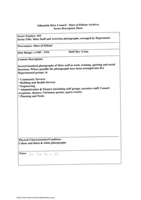
Photograph, View at Eltham, Vic, c.1924
Copy of possible Rose Stereograph Co. postcard “View at Eltham, Vic.”, c.1924 looking southwest from Main Road near York Street to Bridge Street and the original 1875 bridge across what is now the Alistair Knox Park The land in the foreground was first bought from the Crown by J.M. Holloway in 1851. The land was sub-divided and called "Little Eltham". Bridge Street was created as part of the sub-division. Most of the sub-division was residential lots but the creek valley was divided into lots for small farms. Council started to buy the land for the Eltham Town park in the early 1960s. The area was used as a garbage tip and filled above the flood plain of the creek. Development of the land for a park began in the early 1970s. The house on the right was owned for many years by the Hill family until Council bought it in the early 1960s. The house was built in the 1850s or 60s. The house on the left stood on what is now the southwest corner of Susan and Bridge Streets. The Braithwaite family was associated with this house. The double line of fencing in the foreground was a continuation of York Street to the creek. The Bridge Street bridge was built in 1875 and replaced in 1958. (Ref: Early view of Little Eltham; Byways of History by Colleen Ison, Publication unk, 24 August 1982) Reproduced on p61 of 'Pioneers & Painters' Date estimated on same as View at Hurstbridge featuring Wattle Valley EstateThis photo forms part of a collection of photographs gathered by the Shire of Eltham for their centenary project book,"Pioneers and Painters: 100 years of the Shire of Eltham" by Alan Marshall (1971). The collection of over 500 images is held in partnership between Eltham District Historical Society and Yarra Plenty Regional Library (Eltham Library) and is now formally known as the 'The Shire of Eltham Pioneers Photograph Collection.' It is significant in being the first community sourced collection representing the places and people of the Shire's first one hundred years.Digital image 120 format B&W negative Prints 17 x 25 cm and 10 x 15 cmsepp, shire of eltham pioneers photograph collection, eltham, bridge street, bridge, alistair knox park, braithwaite, bridge street bridge, eltham town park, hill family home, main road, pioneers and painters, york street -
 Melbourne Tram Museum
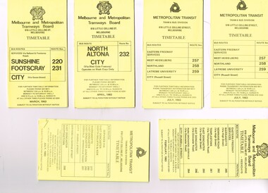
Ephemera - Timetable/s, Melbourne & Metropolitan Tramways Board (MMTB), "MMTB Bus Timetables", 1983
Timetables for specific routes, day of week giving information on tram times at specific time points, route map, sections and fares and organisation address - 616 Little Collins St. Melbourne. All printed on yellow paper unless noted otherwise. .1 - Route 220 and 231 - Sunshine - Footscray - City - March 1983 .2 - North Altona - City via West Gate Freeway - April 1983 .3 - Route 257, 258, 259 - West Heidelberg, Northland, Latrobe University - City - July 1983 .4 - ditto .5 - Route 265, 262, 261, 260, 266, 264 - Warrandyte, Templestowe, Doncaster, Park Orchard - Donvale - City - Feb. 1983 .6 - Route 277, 280, 299, 281 and 268 - Warrandyte, East Doncaster, Donvale, Shoppingtown - July 1983 .7 - Route 287, 286, 302, 303 Box Hill, Mitcham, East Doncaster, Mitcham, Ringwood - June 1980 .8 - ditto - but November 1983 .9 - Route 313, 314, 315, 316 - Warrandyte, Park Orchards, Mitcham - Jan. 1983 .10 - as for .8 11 - Routes 265, 262, 261,260, 266 and 264 - Warrandyte - Eastern Freeway, Templestowe, Park Orcards - Feb. 1983 12 - Routes 277, 280, 281 and 268 - East Doncaster, Donvale, City and Shoppingtown - Jan. 1983 Items .3, .4, .6, .8 and .10 are headed "Metropolitan Transit", rest MMTB.Yields information about MMTB Bus Services 1983Set of 12 MMTB or Metropolitan Transit Bus timetables, folded sheets, generally 10 sections.trams, tramways, mmtb, timetables, melbourne, fares, buses, deer park, sunshine, footscray, latrobe university, northland, heidelberg, box hill, warrandyte, doncaster, donvale, mitcham, ringwood, park orchards -
 Linton and District Historical Society Inc
Card, Greetings, 1st Australian Corps Petrol Park, 1941
Cream coloured card with gold printed text on front and inner page. Card is from Ben Nicol to Mr. Geo. Sandow. Card is contained in an envelope.Text, card front: " GREETINGS / AUSTRALIAN COMMONWEALTH / MILITARY FORCES / 1st AUSTRALIAN / CORPS PETROL PARK / A.I.F. / ABROAD / XMAS 1941. " Text, inside card: " WITH BEST WISHES / FOR / A MERRY XMAS / AND A HAPPY / NEW YEAR. / To Mr. G. Sandow / FROM / Ben Nicol / VX 22271 / 1st A.C.P.P. / H. Section. "ben nicol, george sandow, world war 1939-1945 -
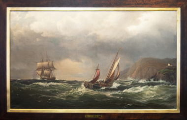 Mission to Seafarers Victoria
Painting - Oil painting, Madeline M.Ravenna Lewellin, Start Point Light, Devonshire, 1875
This painting was inspired by an original painting by Wilhelm Melby held at the National Gallery of Victoria. Melby is a Danish artist (1824-1882). It depicts a famous Devonshire coastal region famous now for its lighthouse and the pick up point for the pilot when entering waters approaching Dartmouth. The sailing vessels pre-date the construction of the famous lighthouse. Over the centuries the view would have been familiar to many sailors as they left or approached the English mainland and south coast ports in the English Channel. Madeline Mary Ravenna Lewellin (1854 – 24 November 1944) was born in Victoria to Dr John Henry Hill Lewellin, a physician, and Grace Elizabeth (née Danneby). She was one of five daughters, and the family lived in Prahran. Lewellin's brother, Captain Herbert Gordon Hill Lewellin, was a commander in the P. and O. fleet (apprentice on the Romanoff, Lieutenant RNR on the HMS Arethusa in 1899, RMS Mongolia in 1913 sunk in 1917, Naldera in 1920). She studied painting at the National Gallery School in 1879 under Eugene von Guerard. She's also known for collecting and painting specimens, and became a member of the Field Naturalists Club of Victoria in 1885. In 1884 she won a silver medal for her studies of fungi. She collected plants for Australian botanist Ferdinand von Mueller, and the variety of Dicrastylis lewellinii (Purple sand-sage) is named after her. Miss Lewellin, who had a love of the sea and ships as subject matter is listed in 1910 as a donor as a 10/6 member donating to the motor launch fund and in 1918 as a working member of the Ladies Harbour Lights Guild which involved regular volunteer shifts at the Mission to Seamen on canteen and other duties.Marine art, Maritime artThis oil painting has a dark polished wood and gold leaf slip. The painting depicts two masted boats. The choppy sea takes up the lower-third of the painting, and the other two-thirds of the image of made up of stormy grey clouds. A rocky cliff face can be seen on the right-hand side of the painting. A small church can be seen on the hillside. The ship on the left third of the painting sits on the horizon line of the sea. The centre ship with two masts appears to be leaning to the right and its deck is exposed to the viewer showing four men attempting to handle the masts and rigging. The left-hand ship with three masts is surrounded by two grey distant silhouetted mast ships. There are three seagulls at the upper left-centre of the image. There are another three gulls down on the lower-left of the image. Front: ENGRAVED PLAQUE: Start Point Light. Devonshire. SIGNATURE: After W. Melby / M.M.R Lewellin. 1875. Reverse: IN BLACK MARKER PEN: * Hang from two points * WHITE STICKER WITH CONSERVATOR DETAILS: Art Conservation Frames / 118 Bridport Street, Albert Park, VIC, 3206 / 9696 9066 / artconservationframers.com.aupainting, ships, mast, church, sea, storm, oil painting, seagulls, madeline r. lewellin, artwork-paintings, ngv, wilhelm melby, eugene von guerard, botanist, rms mongolia, captain herbert gordon hill lewellin (1862-1935), paddy lewellin, reproduction -
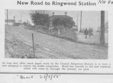 Ringwood and District Historical Society
Newspaper, Ringwood Mail newspaper clipping 28/07/1955 - Construction of new traffic entrance to Ringwood Railway Station
Small newspaper clipping containing photograph and textHeading reads, "New Road to Ringwood Station" Printed below photograph, "At long last, after much paper work by the Council Ringwood Station is to have a new entrance to relieve the traffic congestion. Work has started on the new roadway which will come in through the present car park". "Mail 28/7/55". -
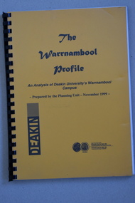 Warrnambool and District Historical Society Inc.
Booklet Lettering Book, Deakin University Planning Unit, The Warrnambool Profile – An Analysis of Deakin University’s Warrnambool Campus, 1999
This booklet was prepared in 1999 by the Planning Unit of Deakin University. It gives current data on the campus and projections and suggestions for the future. The Warrnambool Campus of Deakin University was established in 1990 after a merger with the Warrnambool Institute of Advanced Education which was already on the site that the university still occupies. This is Sherwood Park, a 94 hectare site on the Princes Highway, five kilometres from Warrnambool.This booklet is of some interest as it contains information on the Warrnambool Campus of Deakin University ten years after it was first established. This is a soft cover booklet of 179 pages. It has an orange front cover and a black back cover with black printing and a plastic over-sheet. The booklet has printed information, tables and graphs. It has black plastic spiral binding. deakin university, warrnambool campus -
 Eltham District Historical Society Inc
Negative - Photograph, J.A. McDonald, Eltham, Susan Street, Jan. 1961
January 1961 Looking towards Dalton Street (present-day Withers Way) Just south of Brougham Street. To the immediate left is the present-day car park for the Elham Leisure Centre. The house on the left is immediately opposite Cromwell street and adjacent to the southwest corner of the Leisure Centre buiding (where the Williams house sits hidden from view)Record of various Shire of Eltham infrastructure works undertaken during the period of 1952-1962 involving bridge and road reconstruction projects, sometimes with Eltham Shire Council Project Reference numbers quoted. It was during this period that a number of significant improvements were made to roads and new bridges constructed within the shire that remain in place as of present day (2022). In many situations, the photos provide a tangible visible record of infrastructure that existed throughout the early days of the Shire. The album was put together by or under the direction of the Shire Engineer, J.A. McDonald.shire of eltham, infrastructure, 1961-01, cromwell street, eltham leisure centre, road construction, susan street -
 Eltham District Historical Society Inc
Document - Series Listing, Fraser Faithfull et al, Series 63: Shire Staff and Activities photographs, arranged by Department, 2000
Several hundred photographs of Shire staff at work, training, sporting and social functions. Where possible the photographs have been arranged into five Departmental groups, ie: Community Services Building and Health Services Engineering Administration & Finance (including staff groups, executive staff, Council receptions, dinners, Christmas parties, sports events) Planning and Parksshire of eltham archives, series listing -
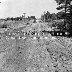
 Eltham District Historical Society Inc
Slide, Main Road, Eltham South, Nov. 1981
Roll of film taken by Eltham Shire Council officers (Nov. 1981) reflecting road infrastructure. Golden Fleece Service Station on left now the Shell/Coles Express. On right is Bremner's Flats where the original Eltham tennis courts were siutaed at the turn of the 20th century and where the circus would be located in the 1950s and 1960s; now Wingrove Park35 mm colour positive transparency (1 of 27) Mount - Kodak Ektachrome CardProcessed 18 Jan 1982infrastructure, main road, roads, bremner's flat, construction, eltham south, golden fleece service station, mount pleasant road, wingrove park -
 Greensborough Historical Society
Article - Article, Journal, Melbourne Harbor Trust, "The Word is Progress": by Robin Hay, 1960_03
The opening of Reid's Lightweight Aggregate Pty Ltd ( a subsidiary of Reid's Quarries Ltd) in Greensborough, circa 1960. Explains the method of manufacture and uses of shalite in building industry. Reid's later became Albion Reid before being taken over by Boral. The shalite quarry, now closed, was on the site now called Blue Lake in Yellow Gum Park, Plenty.7 photocopied pages, text and colour and black nd white illustrations.reids quarries, shalite, aggregate, yellow gum park, plenty -
 Greensborough Historical Society
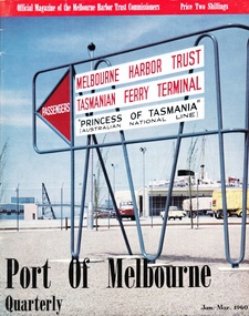
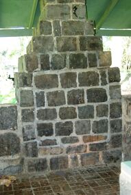
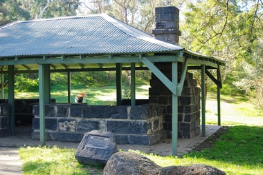
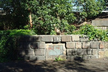
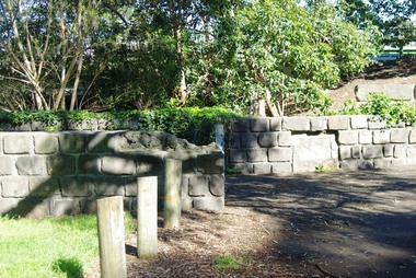
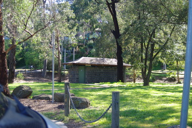
Photograph - Digital Image, Pioneer Reserve 2014 -2, 01/10/2014
Pioneer Reserve, Greensborough is a small park on the corner of St Helena and Diamond Creek Roads. It is adjacent to the site of Greensborough's first bridge across the Plenty River, c. 1864 - 1960s. The shelter, viewing platform, retaining wall and entrance are built from the bridge's massive bluestone arched abutments dismantled between 1974 and 1983. Photograph by Marilyn Smith 2014.Digital copy of colour photograph.pioneer reserve greensborough -
 Greensborough Historical Society
Photograph - Digital Image, Pioneer Reserve 2014 -3, 01/10/2014
Pioneer Reserve, Greensborough is a small park on the corner of St Helena and Diamond Creek Roads. It is adjacent to the site of Greensborough's first bridge across the Plenty River, c. 1864 - 1960s. The shelter, viewing platform, retaining wall and entrance are built from the bridge's massive bluestone arched abutments dismantled between 1974 and 1983. Photograph by Marilyn Smith 2014.Digital copy of colour photograph.pioneer reserve greensborough -
 Greensborough Historical Society
Photograph - Digital Image, Pioneer Reserve 2014 -4, 23/09/2014
Pioneer Reserve, Greensborough is a small park on the corner of St Helena and Diamond Creek Roads. It is adjacent to the site of Greensborough's first bridge across the Plenty River, c. 1864 - 1960s. The shelter, viewing platform, retaining wall and entrance are built from the bridge's massive bluestone arched abutments dismantled between 1974 and 1983. Photograph by Marilyn Smith 2014.Digital copy of colour photograph.pioneer reserve greensborough -
 Greensborough Historical Society
Photograph - Digital Image, Pioneer Reserve 2014 -5, 23/09/2014
Pioneer Reserve, Greensborough is a small park on the corner of St Helena and Diamond Creek Roads. It is adjacent to the site of Greensborough's first bridge across the Plenty River, c. 1864 - 1960s. The shelter, viewing platform, retaining wall and entrance are built from the bridge's massive bluestone arched abutments dismantled between 1974 and 1983. Photograph by Marilyn Smith 2014.Digital copy of colour photograph.pioneer reserve greensborough -
 Greensborough Historical Society
Photograph - Digital Image, Pioneer Reserve 2014 -6, 23/09/2014
Pioneer Reserve, Greensborough is a small park on the corner of St Helena and Diamond Creek Roads. It is adjacent to the site of Greensborough's first bridge across the Plenty River, c. 1864 - 1960s. The shelter, viewing platform, retaining wall and entrance are built from the bridge's massive bluestone arched abutments dismantled between 1974 and 1983. Photograph by Marilyn Smith 2014.Digital copy of colour photograph.pioneer reserve greensborough -
 Greensborough Historical Society
Photograph - Digital Image, Pioneer Reserve 2014, 23/09/2014
Pioneer Reserve, Greensborough is a small park on the corner of St Helena and Diamond Creek Roads. It is adjacent to the site of Greensborough's first bridge across the Plenty River, c. 1864 - 1960s. The shelter, viewing platform, retaining wall and entrance are built from the bridge's massive bluestone arched abutments dismantled between 1974 and 1983. Photograph by Marilyn Smith 2014.Digital copy of colour photograph.pioneer reserve greensborough -
 Greensborough Historical Society
Photograph - Digital Image, Pioneer Reserve 2014 -8, 23/09/2014
Pioneer Reserve, Greensborough is a small park on the corner of St Helena and Diamond Creek Roads. It is adjacent to the site of Greensborough's first bridge across the Plenty River, c. 1864 - 1960s. The shelter, viewing platform, retaining wall and entrance are built from the bridge's massive bluestone arched abutments dismantled between 1974 and 1983. Photograph by Marilyn Smith 2014.Digital copy of colour photograph.pioneer reserve greensborough -
 Greensborough Historical Society
Photograph - Digital image, Trevor Partington's Property, 1960c
Property owned by Trevor Partington. The property was about 1 and three quarter acres on which was a large old and big house which Trevor partitioned into two to have tenant in the back. He used to have horse grazing on the grass. The property was at the lower eastern end of the old 'Church Street' which today is the lowest part of 'The Greensborough Plaza' car park.Digital copy of black and white photograph.trevor partington -
 Greensborough Historical Society
Postcards (framed), Greensborough Historical Society, Greensborough Historical Society Postcards. Series Two, 01/10/2012
Set of 6 postcards produced for sale by Greensborough Historical Society. Postcards Frame 1, top to bottom: Fallen Soldier's Memorial, Main Street 1923; Greensborough Park Tea Rooms 1920s;Greensborough Railway Station 1920s. Frame 2, top to bottom: Stubley Motors 1930s; Greensborough Township early 1900s; Main Street Greensborough 1956.6 black and white postcards in 2 black timber frames, under glass.greensborough historical society, main street greensborough, greensborough station, stubley motors -
 Eltham District Historical Society Inc
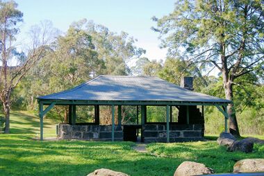
Photograph, Sir Rohan Delacombe meeting members of the Shillinglaw Cottage Preservation Society, 19 September 1973
The State Governor Sir Rohan Delacombe and Lady Delacombe visited the Shire of Eltham where they were entertained to a civic luncheon by the Shire President Cr. L. E. Clarke and councilors at the Panton Hill hotel and made a tour of the shire. Sir Rohan opened Shillinglaw Cottage at Eltham Town Park where they met members of the Shillinglaw Cottage Preservation Society.This photo forms part of a collection of photographs gathered by the Shire of Eltham for their centenary project book, "Pioneers and Painters: 100 years of the Shire of Eltham" by Alan Marshall (1971). The collection of over 500 images is held in partnership between Eltham District Historical Society and Yarra Plenty Regional Library (Eltham Library) and is now formally known as 'The Shire of Eltham Pioneers Photograph Collection.' It is significant in being the first community sourced collection representing the places and people of the Shire's first one hundred years.Digital imagesepp, shire of eltham pioneers photograph collection, eltham, governor of victoria, sir rohan delacombe, shillinglaw cottage preservation society -
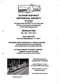 Eltham District Historical Society Inc
Newsletter, Newsletter, No. 198 May 2011
Contents: • Next meeting, guest speaker; Ross McDonald and Bruce Draper: The McDonalds and the Drapers; two significant Nillumbik families • May Meeting • Eltham Lower Park Walk • Eltham Railway Line • Eltham North Bridge • Room Names at Our Local History Centre • Nillumbik Heritage Strategy • Subscriptions • Office Bearers 2011-2012 • And Also The Shire of Eltham Historical Society was formed in October 1967. The first newsletter of the Society was issued May 1978 and has been published continuously ever since on a bi-monthly basis. With the cessation of the Shire of Eltham in late 1994, the Society's name was revised to Eltham District Historical Society and this name first appeared with issue No. 103, July 1995. The collection of the Society's newsletters provides a valuable resource on the history of the Society's activities, office bearers and committee members, guest speakers and subjects of historical interest pertinent to the former Shire of Eltham and the Eltham District.A4 photocopied newsletter distributed to membersnewsletter, eltham district historical society, shire of eltham historical society -
Port Melbourne Historical & Preservation Society
Photograph - Grade 5/6, St Joseph's Primary School, Port Melbourne, 1993
St Joseph's Primary School closed in 1993 to merge with Our Lady of Mount Carmel (Beaconsfield Parade, Middle Park), Sts Peter and Paul's (cnr Bank & Montague Streets, South Melbourne), and Sacred Heart (Grey Street, St Kilda) to form Galilee Regional Catholic Primary School. This is a photo of the last Grade 5/6 class.Colour photograph of Grade 5/6 students at St Joseph's Primary school. Signed with the first names of the students,1993education - primary schools, religion - roman catholic church (st josephs), st josephs catholic primary school -
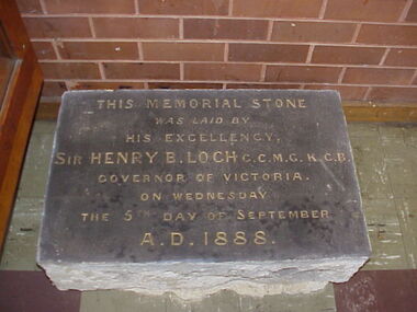 Port Melbourne Historical & Preservation Society
Ceremonial object - Foundation stone, Victorian Seamen's Institute, 1888
During demolition of the 1937 Missions to Seamen building in October 1995, this stone was removed intact by developers Mirvac Victoria, and placed in the care of the PMH&PS. It is now located as part of the seawall around the car park in Beach St opposite Nott St. There is a photo of the item on the database, taken in the 1990s while the stone was stored at St Joseph's school in Stokes St..01- Cornerstone 1888, originally laid at the Victorian Seamen's Institute corner Nott and Beach Street (Fox Hay building today). Was relocated to interior wall near the chapel doors when the new Mission building at corner of Beach Road and Swallow Street was built in 1937.Engraved in gold lettering on a black background: This memorial stone was laid by His Excellenvy Sir Henry B Loch GGMGKCB, Governor of Victoria on Wednesday the 5th day of September AD 1888missions to seamen, henry b loch -
 Tatura Irrigation & Wartime Camps Museum
Photograph, Contemporary Thomas Hogan House
Previous Owner/Occupiers of this house: 1889 Thomas Hogan;1890 Walter Scott Murray; 1895 Dr A. Park; 1909 Marion Reilly; 1909 Dr Ley; 1911 Mrs I. Maidment; 1913 Pat McNamara; 1935 Reilly Bros.; 1971 James Reilly; 1980 Ray Carr; 1985 Alan Tillett; 1987 Shire of Rodney.buildings, historic -
 Hume City Civic Collection
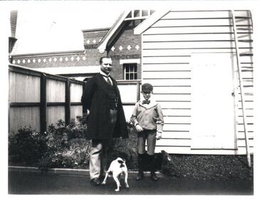
Photograph, c1897
The original photo is part of an album taken by W.Walls, the front page of which is inscribed "The Hill/Sunbury/April 1897". Whilst most of the photos relate to the environs of the asylum, there are others taken around Sunbury and elsewhere. The original album is held as part of the Mental health Library collection. During 2000 this was transfered from Mont Park to the Royal Melbourne Hospital.A man and a boy and a dog are in front of a weatherboard shed and in a garden with a fence. There is a brick building in the background.walls, w., sunbury asylum, walls album, george evans collection -
 Hume City Civic Collection
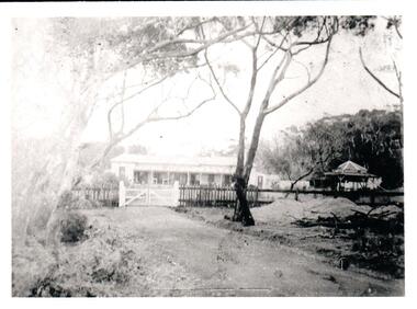
Photograph, c1897
The original photo is part of an album taken by W.Walls, the front page of which is inscribed "The Hill / Sunbury / April 1897". Whilst most of the photos relate to the environs of the asylum, there are others taken around Sunbury and elsewhere. The original album is held as part of the Mental Health Library collection. During 2000 this was transfered from Mont Park to the Royal Melbourne Hospital .One house and an outbuilding is behind a picket fence with a white gate. A road leads to the gate under the trees. Unmounted black and white.walls, w., sunbury asylum, walls album, george evans collection