Showing 11713 items
matching railways
-
 Ballarat Tramway Museum
Photograph - Illustration/s, Sydney and Melbourne trams
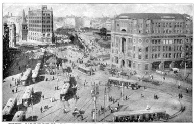
Tear out of a magazine - approx. quarto size of two sepia toned illustrations: Top: Railway Square Sydney - approx. 20 trams and horse drawn vehicles. Lower: Collins St. Melbourne, east, looking west from about Exhibition St. - has two cable trams and horse drawn vehicles. C1900? On rear has series of 5 ink drawings of Australian explorers, Sturt, Leichardt, Mitchell, Eyre and Burke - titled "Australian Explorers"trams, tramways, sydney railway sq., melbourne, cable trams -
 Ballarat Tramway Museum
Slide - 35mm slide/s, early 1960's
Bendigo Charing Cross, looking east towards railway station, with SEC No. 7 about to depart for Eaglehawk. A Birney tram in background heading for Quarry Hill. Photo shows 'Ezywalkin' and 'Fountain Plaza' buildings, has large white with black lettering road signs on left. On centre pole in front of tram is smaller road direction signs (yellow with black letters) for Echuca, Heathcote and Melbourne. Tram has dash canopy lights, early 1960's.niltramways, trams, bendigo, charing cross, quarry hill, eaglehawk, tram 7 -
 Kew Historical Society Inc
Map, MMBW, River Yarra Beautification Schemes, c.1913
The Melbourne and Metropolitan Board of Works (MMBW) was established by an act of the Victorian Parliament in 1890 to prepare for and to implement a sewerage and water reticulation system across what was then inner Melbourne, its surrounding and middle distance suburbs, including Kew. The MMBW was disbanded in 1991.The map collection of the Kew Historical Society has at its core the historic maps assembled and originally stored in the City Engineer's Department of the City of Kew. These include maps in a number of scales. The vast majority of maps were produced by the MMBW in the first two decades of the twentieth century, and are solid working maps, backed by linen for durability. These maps are historically significant to Kew, the City of Boroondara and to the history of the development of state utilities in Victoria. A number of the Kew maps have additional details added by former municipal officers, including the levels reached by various floods. As these were working documents, information was added to them long after the period of their initial production and distribution.Map of the City of Kew showing part of the River Yarra Beautification Schemes. The map shows development to date and the flood levels reached in 1923 and 1924. This map may have been adapted from an earlier map, as most development in central Kew and Studley Park had occurred by this date yet numerous streets are not represented. Public buildings and institutions are clearly represented and named on the map as are significant public transport infrastructure (eg the Outer Circle railway).MELBOURNE AND METROPOLITAN BOARD OF WORKS / RIVER YARRA BEAUTIFICATION SCHEMES / SCHEME / SCALE 10 CHAINS TO AN INCHmelbourne & metropolitan board of works, mmbw maps, mmbw plans, city of kew, flood levels -- kew (vic.), cartography -
 University of Melbourne, Burnley Campus Archives
Album - Black and white and colour prints, Freeway Construction, 1963-1972
(1) 14 photographs showing views of where the Freeway would be going through near Burnley Gardens. (2) 2 photographs of views of the Yarra River near Burnley Gardens. (3) Aerial photograph of construction of the Freeway near Burnley Gardens and Yarra Boulevard. (4) 8 colour photographs of construction work in and over the River Yarra near the railway bridge. "Brian Ward Freeway Construction" handwritten on cover of folder. Student Dux 1973.freeway, burnley gardens, yarra river, yarra boulevard, river yarra, brian ward -
 Tarnagulla History Archive
'Two Historical Gatherings' by Don Clark, Donald Clark, 1988
Donald Clark Collection.Two copies of a typed first-hand account written by amateur historian Donald Clark about two gatherings which occurred in Tarnagulla to commemorate historic events. The first was a bonfire to celebrate Australia's Bi-centenary, held at the Tarnagulla Recreation Reserve on June 18th, 1988, also including unveiling of a plaque to mark the restoration of the band rotunda. The second was a celebration to commemorate the centenary of the 1888 opening of the railway line Dunolly to Inglewood, held on November 20th, 1988. -
 Wodonga & District Historical Society Inc
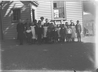
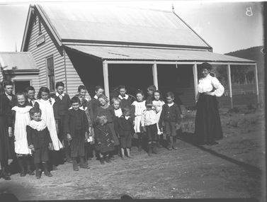
Negative - Haeusler Glass Negatives Collection - Wodonga West Primary School, c1910
The Wodonga Historical Society Haeusler Collection provides invaluable insight into life in late nineteenth and early twentieth century north east Victoria. The collection comprises manuscripts, personal artefacts used by the Haeusler family on their farm in Wodonga, and a set of glass negatives which offer a unique visual snapshot of the domestic and social lives of the Haeusler family and local Wodonga community. The Haeusler family migrated from Prussia (Germany) to South Australia in the 1840s and 1850s, before purchasing 100 acres of Crown Land made available under the Victorian Lands Act 1862 (also known as ‘Duffy’s Land Act’) in 1866 in what is now Wodonga West. The Haeusler family were one of several German families to migrate from South Australia to Wodonga in the 1860s. This digital image was produced from one of the glass negatives that form part of the collection, probably taken by Louis Haeusler (b.1887) with the photographic equipment in the Wodonga Historical Society Haeusler Collection. This item is unique and has well documented provenance and a known owner. It forms part of a significant and representative historical collection which reflects the local history of Wodonga. It contributes to our understanding of domestic and family life in early twentieth century Wodonga, as well as providing interpretative capacity for themes including local history and social history.Digital image created from the Haeusler Glass negative collection. A group of children and their teacher outside Wodonga West Primary School No. 1058. C.1910. The school was located near the current intersection of McKoy Street and the Hume Freeway in West Wodonga on land donated by J.W. Klinge, replacing an older school north of the railway line. It operated from January 1870 to May 1950 when the nine remaining students transferred to Wodonga Primary School. wodonga pioneers, haeusler family, glass negatives, dry plate photography, wodonga west primary school, schools wodonga -
 Wodonga & District Historical Society Inc
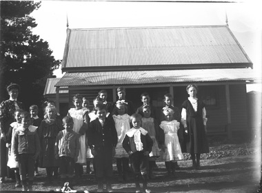
Negative - Haeusler Glass Negatives Collection - Wodonga West School and pupils, c1910
The Wodonga Historical Society Haeusler Collection provides invaluable insight into life in late nineteenth and early twentieth century north east Victoria. The collection comprises manuscripts, personal artefacts used by the Haeusler family on their farm in Wodonga, and a set of glass negatives which offer a unique visual snapshot of the domestic and social lives of the Haeusler family and local Wodonga community. The Haeusler family migrated from Prussia (Germany) to South Australia in the 1840s and 1850s, before purchasing 100 acres of Crown Land made available under the Victorian Lands Act 1862 (also known as ‘Duffy’s Land Act’) in 1866 in what is now Wodonga West. The Haeusler family were one of several German families to migrate from South Australia to Wodonga in the 1860s. This digital image was produced from one of the glass negatives that form part of the collection, probably taken by Louis Haeusler (b.1887) with the photographic equipment in the Wodonga Historical Society Haeusler Collection. This item is unique and has well documented provenance and a known owner. It forms part of a significant and representative historical collection which reflects the local history of Wodonga. It contributes to our understanding of domestic and family life in early twentieth century Wodonga, as well as providing interpretative capacity for themes including local history and social history.Digital image created from the Haeusler Glass negative collection. A group of students and their teacher standing outside Wodonga West Primary School No. 1058. C.1910. The school was located near the current intersection of McKoy Street and the Hume Freeway in West Wodonga on land donated by J.W. Klinge, replacing an older school north of the railway line. It operated from January 1870 to May 1950 when the nine remaining students transferred to Wodonga Primary School.wodonga pioneers, haeusler family, glass negatives, dry plate photography, wodonga west school -
 Wodonga & District Historical Society Inc
Negative - Haeusler Glass Negatives Collection - Teachers and Students Wodonga West Primary School, c1910
The Wodonga Historical Society Haeusler Collection provides invaluable insight into life in late nineteenth and early twentieth century north east Victoria. The collection comprises manuscripts, personal artefacts used by the Haeusler family on their farm in Wodonga, and a set of glass negatives which offer a unique visual snapshot of the domestic and social lives of the Haeusler family and local Wodonga community. The Haeusler family migrated from Prussia (Germany) to South Australia in the 1840s and 1850s, before purchasing 100 acres of Crown Land made available under the Victorian Lands Act 1862 (also known as ‘Duffy’s Land Act’) in 1866 in what is now Wodonga West. The Haeusler family were one of several German families to migrate from South Australia to Wodonga in the 1860s. This digital image was produced from one of the glass negatives that form part of the collection, probably taken by Louis Haeusler (b.1887) with the photographic equipment in the Wodonga Historical Society Haeusler Collection. This item is unique and has well documented provenance and a known owner. It forms part of a significant and representative historical collection which reflects the local history of Wodonga. It contributes to our understanding of domestic and family life in early twentieth century Wodonga, as well as providing interpretative capacity for themes including local history and social history.Digital image created from the Haeusler Glass negative collection. A group of students with their teacher standing outside their school building at Wodonga West, Victoria No. 1058. The school was located near the current intersection of McKoy Street and the Hume Freeway in West Wodonga on land donated by J.W. Klinge, replacing an older school north of the railway line. It operated from January 1870 to May 1950 when the nine remaining students transferred to Wodonga Primary School.wodonga pioneers, haeusler family, glass negatives, dry plate photography, wodonga west primary school -
City of Kingston
Photograph - Colour, 31 January 1993
Patterson Lakes is a suburb in the City of Kingston that is built one kilometre upstream of the mouth of the Patterson River. The area is bordered by the Patterson River and Eel Race Drain which enters the Kananook Creek. The suburb consists predominantly of newer housing developments and the tidal canal system of the development joins Port Phillip Bay. Patterson Lakes and the Kananook Creek were previously part of the extensive Carrum Carrum Swamp. The area was once a source of fish and eels for the Mayone-Bulluk clan of the Bunurong people. Over time the area was drained and in 1973 investigations commenced into the development of a unique residential area that would be built adjacent to canals and waterways. It was originally proposed to be known as "Gladesville". The development would give the suburb's homeowners access to Port Phillip Bay "from their back door". Circa 1974, the area was rezoned from rural to residential and named Patterson Lakes. Development has been continuous since the 1970s with construction of residential housing, schools, shopping centres, marinas, a hotel and library.Laminated colour aerial photograph of the Carrum and Patterson Lakes region within City of Kingston. This 1993 image includes Patterson River Secondary College, Roy Dore Reserve, Kananook Creek and Nepean Highway. The railway line can be seen as it veers inland from Eel Race Road, Seaford. The section of Ocean Reef Drive and Palm Beach Drive in Patterson Lakes appears to be a recent development with many spare blocks and new houses under construction.Black typed lettering on white adhesive label: 31.1.93 Black typed lettering on white adhesive label: 27E/7140 31/1/93 12.55 pm Black typed lettering on white label: 7140 Yellow round adhesive label located on left sidepatterson lakes, seaford, kananook creek, carrum carrum swamp, canals and waterways -
 Melbourne Tram Museum
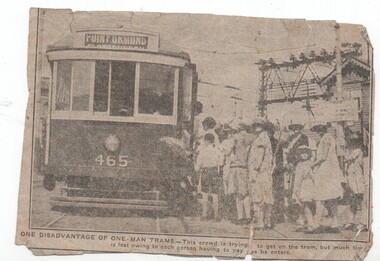
Newspaper, One man trams - their disadvantage when crowded, c1920's
Newspaper cutting from an unknown Melbourne newspaper with a photo of X1 465 loading passengers at Glenhuntly Road Elsternwick, with the signal box and railway overhead in the background. Notes the disadvantage of one many trams, with a large crowd having to pay separately as they enter. Has on the rear a piece of The Age with the date Wednesday 26 October to mend the cutting which has been torn. Dress of the ladies is 1920's with large hats. Tram has the destination of Point Ormond.trams, tramways, point ormond, one man trams, glenhuntly rd, elsternwick, level crossings, tram 465, x1 class, mmtb -
 Melbourne Tram Museum
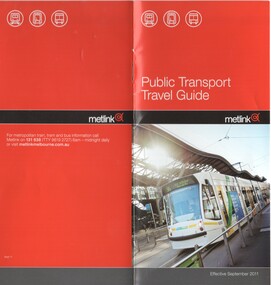
Pamphlet, Metlink, "Public Transport Travel Guide", Sep. 2011
Pamphlet "Public Transport Travel Guide" - effective Sept. 2011. .Book - DL size, red coloured covers 12 pages, centre stapled, colour printed on gloss paper, has table of contents. Givers details on travelling conditions, accessibility, Authorised Officers, Customer Feedback, Public transport organisations, Passenger information, Hours of Operation and Translated information. Has photo of Yarra Trams 5013 outside Southern Cross Railway Station on front cover.trams, tramways, tickets, fares, connex, guides, yarra trams, metlink, tram 5013 -
 Melbourne Tram Museum
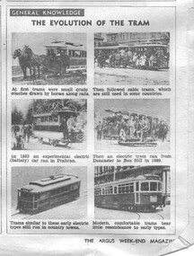
Newspaper, The Argus, The evolution of the tram, 1947 to 1950
Set of three newspaper cuttings from The Argus - Students section. .1 - General Knowledge - has photos of 6 Victorian tramcars with notes - 3/5/1947 - has advert for Parsons Custard Powder on the rear. .2 - Travel - Tramways and Protests - about the derivation of the word tramways and railways and their development -6/5/1950. 3 - Australiana - Australia's first electric tram - details the Box Hill to Doncaster tramway with an image of the poster - 15/7/1950.trams, tramways, tramways, box hill, doncaster, tramcars -
 Melbourne Tram Museum
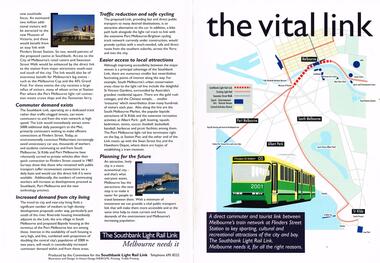
Pamphlet, Committee for the Southbank Light Rail Line, "the vital link", 1993?
Pamphlet - full colour A3 sheet folded to A4, titled "the vital link", outlining a proposal for a tram line connecting Flinders St station to Clarendon St, Port Junction, via the former railway bridge, connecting Batman Ave tram line. Published by the Committee for the Southbank Light Rail Line. Gives reasons and benefits for such a link. Published based on a printing date 1993. Features an image of 2001 on front cover and crossing the Yarra River.trams, tramways, flinders st station, clarendon st, new tramway, batman ave, route 96, light rail, yarra river, tram 2001 -
 Melbourne Tram Museum
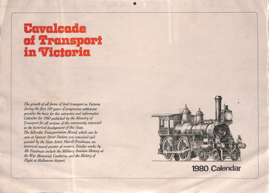
Ephemera - Calendar, Ministry of Transport, "Cavalcade of Transport in Victoria - 1980 Calendar", 1979
Calendar, four pages, full colour titled "Cavalcade of Transport in Victoria - 1980 Calendar", four months per sheet, featuring Harold Freedman, Transport Mural at Spencer St Railway station. The front cover has a short description of the mural. Features Melbourne's trams. Tear off calendars with hanging hole in the top edge centre and Perforated to enable the image to be framed separately. See Reg Item 3671 for the launch of the Mural at the 1978 Cavalcade of Transport.trams, tramways, calendar, spencer st, mural, southern cross station -
 Melbourne Tram Museum
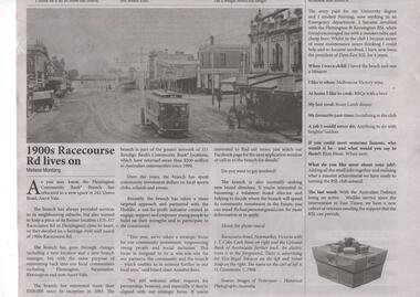
Newspaper, Flemington Kensington News, "1900s Racecourse Rd lives on", Original photo c1906
Newspaper clipping from the Summer issue of Flemington Kensington News titled "1900s Racecourse Rd lives on", featuring a photo of a NMETL enclosed tramcar east bound in Racecourse Road at the intersection with Wellington St Flemington showing the centre poles and buildings in the street. In the background is the railway overbridge. On the corner is a Tailor and Hatter shop. Item written by Melissa Montang, mainly about the Bendigo Community Bank relocating from Racecourse Road. Source of the photograph - Images of Yesteryear.trams, tramways, racecourse rd, nmetl, flemington -
 Melbourne Tram Museum
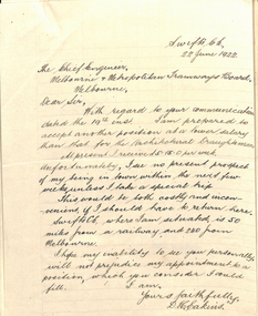
Document - Memorandum, D. H. Eakins, David Eakins appointment, Jun. 1922
Memorandum consisting of 11 quarto type and handwritten sheet or letters, appointing David Eakins as a assistant to Mr Lormer for the preparation of the General Scheme. Includes references, letter of application, and other reference material supplied by Mr. Eakins and signed by the Chief Engineer Mr Strickland. Memo to the Chairman dated 26/6/1922. Mr Eakins was to become the Chief Engineer in the 1950's. Includes a reference from Mr. Maurice Kernot chief Engineer for Railway Construction.trams, tramways, chief engineer, personnel, staff, engineers, general scheme -
 Melbourne Tram Museum
Document - Lecture Notes, Keith Kings, "The Privatisation of Melbourne's Public Transport - Has the Wheel turned full circle?", 30/04/2002 12:00:00 AM
Printed report or address or lecture - 10 pages titled "The Privatisation of Melbourne's Public Transport - Has the Wheel turned full circle?" by Keith Kings for the 2nd annual RMIT Sir Robert Risson Memorial Lecture 30 April 2002. The address looks at the history of Melbourne's transport, railways, buses, tramways and tramway buses, cable trams, formation and dismantling of the PTC, ticket machines, road traffic, bus industry consolidation, privatisation of transport in Melbourne.trams, tramways, melbourne, privatisation, buses, public transport, ptc -
 Melbourne Tram Museum
Document - List, "List of Opening and conversion dates - Melbourne Tramways", c1990
Six page list of opening, closing or conversion dates of Melbourne tramways including Box Hill, horse trams, Victorian Railways, cable line, tramway trusts. Page 6 has a list of the cable tramways with route mileage, route colour and years operated. Format has similarities to the "Timeline history of Melbourne's Government Cable and Electric Trams and Buses" by Barry George, Don Storey John Birch et al. Possibly produced for a tram tour.trams, tramways, mmtb, mto co, opening, melbourne -
Bendigo Historical Society Inc.
Domestic Object - MUNCEY COLLECTION: SILVER TEA SERVICE, 1898
Silver plated tea service presented to Henry Muncey by his colleagues at the The New Chum Mine on his marriage to Eliza Brooks in 1898. The service consists of a silver coffee pot, a silver tea pot, silver sugar bowl and silver creamer. All items are decoratively engraved with scroll work, floral emblems and punch work. The coffee pot is engraved with the words " Presented to H Muncey by employees New Chum Railway GMC on his marriage 3.2.98".A lozenge with the letters EP with a reclined S in a diamond. William Mammatt & Sons Sheffield.henry muncey, new chum gold mine, eliza brooks, 1898, marriage -
 Bendigo Historical Society Inc.
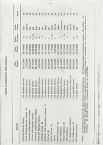
Document - SANDHURST BUILDING SOCIETY CENTENARY 1981 CALENDAR
Buff Paper, Sepia Text & Illustrations 7 Pages Views of Sandhurst 1881 Calendar Images: Beehive Chambers and Mining Exchange Hotel, Pall Mall; panorama from Post Office Tower looking north to White Hills; Sandhurst Post Office Pall Mall; Sandhurst Railway Station (opened 1862) and Quarry Hill;Alexandra Fountain, Charing Cross, (opened 1881); panorama from Post Office Tower looking south to Golden Square.bendigo, history, sandhurst building society calendar -
Glen Eira Historical Society
Document - Memorials in Glen Eira
... Railways ...This file contains one item: 1/A printout from the Victorian Memorials Database, undated and researcher unknown, containing records of 9 memorials in the Caulfield City municipality. These memorials are: - Caulfield Grammar School Site Pavement Marker, Elsternwick - Monument to racehorse ‘Jackstaff’ in Caulfield Racing Museum. - Rosstown Railway Marker, Bambra Road, Caulfield. - Thomas Alexander Browne Grave, Brighton Cemetery. - Grave of Sir John and Lady Monash, Brighton Cemetery. - Frederick Jowett Memorial Drinking Fountain, Caulfield Town Hall - Adam Lindsay Gordon Grave, Brighton Cemetery. - Jewish victims of World War 2 Memorial, Kadimah Centre, Elsternwick. - Hopetown Gardens Cannon, Elsternwick.historical markers, caulfield city, caulfield grammar school, elsternwick, regent street, caulfield racing museum, rosstown railway marker, caulfield, bambra road, curraweena road, marara road, city of caulfield, mayors, councillors, caulfield historical society, rosstown railway, caulfield grammar school pavement marker, monument to racehorse ‘jackstaff’, ross murray, browne thomas alexander, thomas alexander browne grave, brighton cemetery, rolf boldrewood, north road, caulfield south, browne margaret maria, grave of sir john and lady monash, monash john sir, monash hannah victoria lady, frederick jowett memorial drinking fountain, caulfield town hall, hawthorn road, glen eira road, jowett frederick, borough of caulfield, adam lindsay gordon grave, gordon adam lindsay, gordon annie lindsay, jewish victims of world war 2 memorial, kadimah jewish cultural centre and library, selwyn street, burston seddon, hopetoun gardens cannon, glenhuntly road, glen huntly road, schools, historic sites, plaques, footpaths, horseracing, horses, jackstaff, monuments and memorials, railways, authors, cemeteries, graves, gravestones, jewish community, town clerks, shire secretaries, town hall, drinking taps, poetry, children, libraries, world war 1939 – 1945, hopetoun, cannons, festivals and celebrations -
 Warrnambool and District Historical Society Inc.
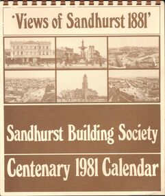
Tickets, Old Transport Tickets x5, 1950
These tram tickets were issued by the Melbourne and Metropolitan Tramways Board which operated from 1919 to 1983 and the train ticket was issued by the Victorian Railways. The Williamstown Short Road Ferry operated from 1931 to 1974 from Port Melbourne to Williamstown and was replaced by the West Gate Bridge which opened in 1978. This was the third ferry service in this area, with the first one commencing in 1873. These tickets have social significance as examples of the tickets used by Melbourne transport in the 1950s. They will be useful for display.These are five paper transport tickets (Melbourne tram & train and Williamstown ferry). The tram tickets are coloured orange and pink, the ferry ticket is green and the train ticket (made of light cardboard) is orange and yellow. The two orange tram tickets, (cost threepence) have an advertisement for Stamina Trousers on the back. They were purchased on the same day. The other tram ticket is a City Section ticket costing fivepence. The ferry ticket cost threepence and the train ticket for travel between Jolimont and Seaholme cost three shillings and fivepence. The tram tickets except for the City Section tram one have been punched with the characteristic punch of the conductor during those journeys. ‘Ask for Stamina self-supporting trousers, Thought for the Month, We become like those we habitually admire’. melbourne tram, train and ferry tickets., warrnambool -
 Eltham District Historical Society Inc
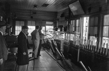
Photograph, George Coop, Newport Signal Box, Newport Railway Station, c.1951
Now demolished. Newport Railway station, visible through the windows was situated on the opposite side of the Melbourne Road level crossing. All of this infrastructure has since been replaced by a large overpass, the level crossing now the location of a pedestrain underpass. One of several photos at Newport taken the same day in the early 1950s when George Coop was a secondary school student.Digital TIFF file Scan of Kopdak 620 black and white negative transparencygeorge coop collection, newport railway station, level crossing, melbourne road, newport signal box -
 Lara RSL Sub Branch
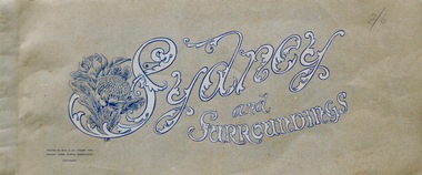
Booklet, Sydney and Surroundings Win and Co Sydney, circa 1945
Photos from 1945 era include Sydney Harbour Bridge, Aerial View looking South East McMahon's Point, Aerial view of Sydney Harbour Bridge looking South West from over Neutral Bay. Top portion of the Bulli Pass. An Entrancing View of the South Coast, from Sublime Point. Government House, Sydney. Central Square Railway Station. Booklet from WW2 era that displays old photographs of the Sydney area circa 1945Sydney and Surroundings Win and Co Sydney containing eight double sided pages of photograph of the Sydney area.Front Cover - Sydney and Surroundings. In bottom left hand corner - Printed by Winn & Co. Sydney, for Murray Views, Gympie, Queensland. Copyright. At top right hand corner in pencil is the price 2/6 On Back Cover - Stamp - Tivoli Bookshop 335 Castlereagh St, Sydney - Books, Magazines, Stamps sydney, winn & company, murray views, gympie, queensland -
 Greensborough Historical Society
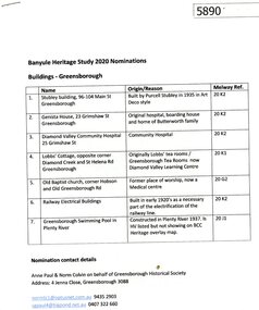
Document - Submission, Anne Paul et al, Banyule Heritage Study 2020 Nominations: Buildings - Greensborough, 2020
Descriptions and photographs of seven early building of historical interest in Greensborough, nominated for the Banyule Heritage Study 2020 by Norm Colvin and Anne Paul on behalf of the Greensborough Historical Society. Buildings include: Stubley building, Genista house, Diamond Valley Community Hospital, Lobb's Cottage, Old Baptist church, railway electrical buildings, swimming pool in Plenty River at Greensborough.8 p., text and colour photographs.historic buildings, banyule heritage study 2020, greensborough -
 Greensborough Historical Society
Map, Heidelberg: Historic River Landscape Assessment. Historical maps. Map E 1901-1934 "A Time of projects and improvements", 1985c
Geographical area of around 35 sq. kilometres marked with physical features such as major roads, railways (new extension to Eltham), rivers and properties, also housing sub-divisions and community facilities such as hospitals, parks and sporting reserves and indications of new small scale industries such as dairying. Bounded by Shire of Diamond Valley to the North, Darebin Creek to the West and Plenty River to the East. Black and white sketch map on white paperheidelberg, heidelberg - maps -
 Greensborough Historical Society
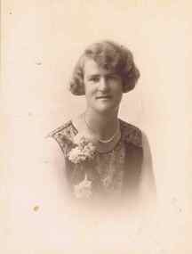
Photograph - Digital image, Jean Partington, 1925c
Miss Jean Partington (1903-1992) was Headmistress at Preston Girls’ School. She lived in the family home at 25 Hailes Street until it was demolished for Greensborough Plaza. Her ashes were spread at the old oak tree, next to the railway line, opposite her old home site which in 2017 is the site of the McDonald's franchise in the Greensborough Plaza car park.Digital copy of black and white studio photograph.jean partington -
 Eltham District Historical Society Inc
Newsletter, Newsletter, No. 4, November 1978
Contents: • Next meeting • Other coming events o Eltham Living Forum o Historical Exhibition o Smiths Gully Excursion o Committee meeting o Next year • Early Eltham house, Ely Street • Kinglake National Park • Kangaroo Ground School • Pioneers and Painters • Railway Trestle Bridge, Eltham • Local History Series • Yemmerrawannie The Shire of Eltham Historical Society was formed in October 1967. The first newsletter of the Society was issued May 1978 and has been published continuously ever since on a bi-monthly basis. With the cessation of the Shire of Eltham in late 1994, the Society's name was revised to Eltham District Historical Society and this name first appeared with issue No. 103, July 1995. The collection of the Society's newsletters provides a valuable resource on the history of the Society's activities, office bearers and committee members, guest speakers and subjects of historical interest pertinent to the former Shire of Eltham and the Eltham District.A4 photocopied newsletter distributed to membersnewsletter, eltham district historical society, shire of eltham historical society -
 Eltham District Historical Society Inc
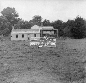
Negative - Photograph, George W. Bell, Re-erection of Shillinglaw Cottage, c.1966
View looking up from near the Eltham Railway Trestle Bridge over what was to become the Eltham Common at Shillinglaw Cottage in its new location prior to restoration. The former Gahan house, seen in the background was demolished in 1968 when the Main Road was duplicated in this section. The Eltham Common was taken over with the construction of the new Eltham Library which opened in 1994.Shillinglaw Cottage is itself historically, aesthetically and socially significant to the Shire of Nillumbik and is registered on the Victorian Heritage Database. This photo forms part of a collection of photographs gathered by the Shire of Eltham for their centenary project book, "Pioneers and Painters: 100 years of the Shire of Eltham" by Alan Marshall (1971). The collection of over 500 images is held in partnership between Eltham District Historical Society and Yarra Plenty Regional Library (Eltham Library) and is now formally known as 'The Shire of Eltham Pioneers Photograph Collection.' It is significant in being the first community sourced collection representing the places and people of the Shire's first one hundred years.Digital image 4 x 5 inch B&W Negsepp, shire of eltham pioneers photograph collection, eltham, shillinglaw cottage, eltham shire office, gahan house, derril, gahan, george w. bell collection, houses, main road -
 Orbost & District Historical Society
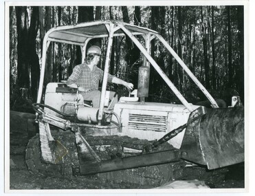
black and white photograph, VR Printing Works, 1975
This photograph, one of set of six, shows Ken Donchi, the youngest family member (at the time of photograph) at work as a sleeper cutter in the Orbost area since the 1890s. The photograph was used in an article for the Victorian Railways Magazine 1975. . It contains photographs and an article about Orbost as "Timber Country" and a detailed article titled, " Cutting Sleepers is a Family Business" which tells about the Donchi family.This item is associated with the timber and sleeper-cutting industry in the Orbost Region. Timber sleepers were superceded by concrete sleepers in c. 1970s. Orbost has historically been based on the timber industry, but that industry has declined considerably over the last 20 years. .The number of locals involved in the timber industry has declined and many of the mills have closed. This item reflects a time when that industry was a significant contributor to the economy of the district.A black / white photograph of Ken Donchi driving a bulldozer in bushland outside of Orbost.on back - Pr 8769donchi-pat sleeper-cutting timber-industry-orbost-railway