Showing 17169 items matching "bay-bridge"
-
 Port Melbourne Historical & Preservation Society
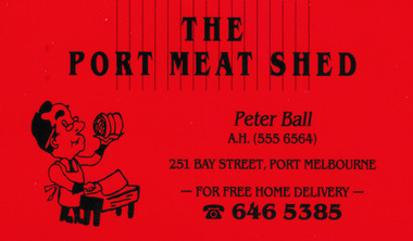
Card - The Port Meat Shed Business Card, c.1980
Peter BALL's business card for the Port Meat Shed has the name, phone numbers and address at 251 Bay Street Port Melbourne and also offers Free Home Delivery.Small red business card with black printing .the port meat shed, business and traders - butchers, peter ball -
 Ballarat Tramway Museum
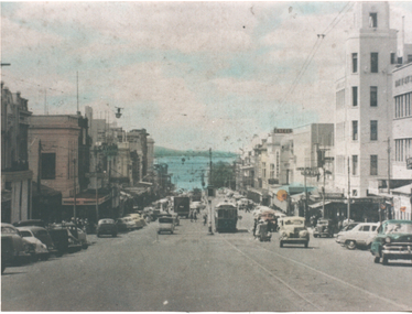
Photograph - Geelong 38 Moorabool St, early 1950s
The photograph shows SEC Geelong 38 in Moorabool St looking north to Corio Bay. Has the T&G and the Bank of NSW in the view. Photo possibly a reproduction from a postcard.Yields information about Moorabool St Geelong in the early 1950s.Colour print with plain back on Agfa paper. tramcars, trams, geelong, moorabool st -
 Kew Historical Society Inc
Plan, Melbourne & Metropolitan Board of Works : Borough of Kew : Detail Plan No.1302, 1910
The Melbourne and Metropolitan Board of Works (MMBW) plans were produced from the 1890s to the 1950s. They were crucial to the design and development of Melbourne's sewerage and drainage system. The plans, at a scale of 40 feet to 1 inch (1:480), provide a detailed historical record of Melbourne streetscapes and environmental features. Each plan covers one or two street blocks (roughly six streets), showing details of buildings, including garden layouts and ownership boundaries, and features such as laneways, drains, bridges, parks, municipal boundaries and other prominent landmarks as they existed at the time each plan was produced. (Source: State Library of Victoria)This plan forms part of a large group of MMBW plans and maps that was donated to the Society by the Mr Poulter, City Engineer of the City of Kew in 1989. Within this collection, thirty-five hand-coloured plans, backed with linen, are of statewide significance as they include annotations that provide details of construction materials used in buildings in the first decade of the 20th century as well as additional information about land ownership and usage. The copies in the Public Record Office Victoria and the State Library of Victoria are monochrome versions which do not denote building materials so that the maps in this collection are invaluable and unique tools for researchers and heritage consultants. A number of the plans are not held in the collection of the State Library of Victoria so they have the additional attribute of rarity.Original survey plan, issued by the MMBW to a contractor with responsibility for constructing sewers in the area identified on the plan within the Borough of Kew. The plan was at some stage hand-coloured, possibly by the contractor, but more likely by officers working in the Engineering Department of the Borough and later Town, then City of Kew. The hand-coloured sections of buildings on the plan were used to denote masonry or brick constructions (pink), weatherboard constructions (yellow), and public buildings (grey). The absence of buildings and or property in Kew facing the Yarra is the most notable feature of this plan. Walmer Street and its bridge stretched, then and now, from Studley Park Road to Victoria Street, Richmond. On the Richmond side of the Yarra, there was evidence in 1904 of industry (‘Wool shed’; Soap Works’) and entertainment (‘Skittle Alley’). In reality, another Plan (No.1303) shows Chinese Gardens bordering the Yarra on the Kew side and buildings in Young Street.melbourne and metropolitan board of works, detail plans, mmbw 1302, cartography -
 Glenelg Shire Council Cultural Collection
Souvenir - Medal, 1934
Circular copper medal with loop at top. Centenary of Portland on one side bust of Edward Henty in relief and the text 'To commemorate the 100th anniversay of the first settlement 1934-1934'. On the other side image of Lt. Grant on the 'Lady Nelson' and the text "Lieut. James Grant discovering and naming Portland Bay 1800'. -
 Bendigo Historical Society Inc.
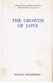
Book - ALEC H CHISHOLM COLLECTION: BOOK ''THE GROWTH OF LOVE'' BY WILLIAM BAYLEBRIDGE
Book. ALEC H CHISHOLM COLLECTION. 255 page hardcover book of collected verse of William Baylebridge (Memorial Edition) Volume 3. Author's revised text edited with a preface by P.R.Stephenson. Published by Angus & Robertson, Sydney, in 1963. Printed by Halstead Press, Sydney. Catalogue sticker '2102 BAY' on spine.William Baylebridgebooks, collections, poetry, alec h chisholm collection, william baylebridge, poetry -
Port Melbourne Historical & Preservation Society
Photograph - Various streets in Port Melbourne, Ron Laing, 1990 - 1999
Part of Ron LAING's collection of photographs recording Port Melbourne over a thirteen year period. Donated to the PMH&PS by the photographer.A set of 49 colour photographs of varous streets in Port Melbourne, including Graham Street, Swallow Street (before and after wrecking), Bain Street, Graham overpass, Williamstown Road, Normanby Road, Ross Street and Bay Street, Princes Street March 1999 (Number 48 missing August 2015)built environment, ron laing -
Port Melbourne Historical & Preservation Society
Photograph - Demolitions in Port Melbourne, Ron Laing, 1986 - 1999
Part of Ron Laing's collection of photographs recording Port Melbourne over a thirteen year period. Donated to the PMH&PS by the photographer.A set of 61 colour photographs of demolitions in Port Melbourne, including Doc's house in Byrne Street, Milk bar/paper shop/sub PO cnr Graham and Albert Streets, Gainsborough House 184 Station Street plus new buldings on the site, Earl's site and replacement in Bay and Nott Streetsbuilt environment, demolitions, ron laing -
Port Melbourne Historical & Preservation Society
Plan - MMBW, Melbourne and Metropolitan Board of Works (MMBW), 1894 - 1895
Located on State Library Victoria (SLV) website by member Ray JelleyMelbourne Metropolitan Board of Works (MMBW) waste water (sewer) plans from 1894-95. Plan numbers 322, 331, 335, 564, 565, 575. Area bounded by Liardet St, East Esplanade, Foote St, Johns(t)on St and Hobsons Bay. Includes Gas works and Distillery.engineering - board of works, sewerage, mmbw, melbourne and metropolitan board of works -
Port Melbourne Historical & Preservation Society
Document - Property valuation working papers, J E Earl, Bay Street, Port Melbourne, George Levey, 1950 - 1974
Sample of working papers relating to the valuation of 29 premises in Port Melbourne. These papers were maintained by Mr George LEVEY, who was the City Valuer for PMCC from around the mid 1950s to about 1974. Details are all in manilla folders. .05 - J E Earl. 181-189 Bay Streetbuilt environment - commercial, business and traders, local government - city of port melbourne, industry, george levey, j e earl pty ltd -
 Otway Districts Historical Society
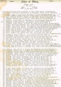
Voters, Shire of Otway, Shire of Otway, Voters' Rolls, 1963, 23 July 1963
After going to a Revision Court where the voters' rolls had been revised and certified correct every voter on the Shire of Otway register was listed with his or her surname, christian names, residence or post town, nature of calling or occupation, situation and description of property, the yearly value, and the number of votes to which the incumbent was entitled. It included both local residents and residents from other municipalities who owned allotments in the Shire of Otway entitled to vote in Shire of Otway elections.Typescript. Shire of Otway, Voters' Roll for the East (a), Central (b), West (c) and Apollo Bay [comprising a portion of the Parish of Krambruk] (d) Ridings, made in the year 1963. Certified for each riding that it "has been revised and is correct", signed by W.H. Tann, Chairman of Revision Court, 23rd July, 1963.Variously underlined, marked, and written on the verso.shire; otway; voter roll; -
City of Kingston
Photograph - Black and white, 20 December 1945
This aerial image covers a section of Cheltenham, with a large paddock yet to be converted to an industrial and later a commercial zone.This aerial photograph provides evidence of the changing landscape of Cheltenham and Highett since WWII. Photographed in 1945, the image features a large block of land now the site of site the major transformation of Cheltenham with the development of the Southland shopping centre in the 1960s and expansion in the 1990s.Aerial photograph of the Cheltenham area in the City of Kingston. This 1945 image is concentrated on the area between Bay Road and Garfield Lane with the distinctive bend into Jean Street. A large block of land runs between the Nepean Highway and the rail line. This is now the area occupied by the extension of Southland in the 1990s. It is a negative version of VKHC124.cheltenham, southland, market garden -
 City of Kingston
Map - Parish of Moorabbin
Warning: This object includes historical language referring to First Nations Peoples which is no longer appropriate but has been recorded for historical purposes. Produced in 1853, this map shows the land holdings of European families. While the majority of holdings are small there are also large land holdings as can be seen with Henry Dendy's Special Survey. Of particular note is the "Reserve for Aborigines" which was established in approximately 1841 and consisted of over 830 acres. This area is the current location of Mordialloc township and Attenborough Park, in Mordialloc, is the last remnant of the reserve. An Alfred Sikes, possibly the surveyor/cartographer who drew this parish plan, purchased land in Berwick in 1854.A handrawn map on fabric, with blue markings representing the coastline to Port Phillip Bay, red markings representing a proposed train line to Mordialloc, major roads and street, as well as a "Reserve for Aborigines", which constituted approximately 830 acres. In the bottom right hand corner, the map has been signed and dated.Handwritten in ink: Alfred Sikes / 38 Collins St East / June. 1853moorabbin, mordialloc, dendy, port phillip bay, aboriginal reserve, attenborough park -
 Lakes Entrance Historical Society
Photograph - Lake Tyers House, 1995
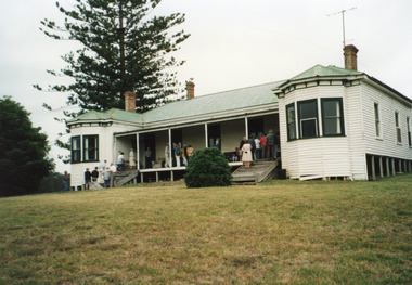
Lake Tyers House built 1886 by R Krokel of Bairnsdale as guest house and stop over being on the coastal road to Orbost and Merimbula. Guest house from 1886 to 1960's.Colour photograph taken at Lake Tyers House, a large timber dwelling built in Victorian Italianate style with two projecting faceted bay windows, corrugated iron roof. Three internal brick chimneys visible through roof. Situated on a prominent headland with a view of Lake Tyers. Lakes Tyers Victoriaaccommodation, guesthouses -
 National Vietnam Veterans Museum (NVVM)
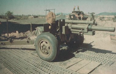
Photograph, Gibbons, Denis, Howitzer Dust Protection 1
Denis Gibbons (1937 – 2011) Trained with the Australian Army, before travelling to Vietnam in January 1966, Denis stayed with the 1st Australian Task Force in Nui Dat working as a photographer. For almost five years Gibbons toured with nine Australian infantry battalions, posting compelling war images from within many combat zones before being flown out in late November 1970 after sustaining injuries. The images held within the National Vietnam Veterans Museum make up the Gibbons Collection.A coloured photograph of a 105mm gun, covered against dust, sits silent in its bay at a Fire support Base at the base of the Nui Thai Vai Mountains, Phuoc Tuy Province, South Vietnam. The Fire Base was supporting 1 ATF Units sweeping through the caves of the mountains. (Circa October 1969)photograph, 105mm howitzer, fire support base, nui thai vai mountains, phuoc tuy province, 1 atf, gibbons collection catalogue, denis gibbons, nui dat -
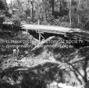
 Eltham District Historical Society Inc
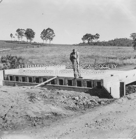
Album - Photograph, J.A. McDonald, Heidelberg-Kinglake Road, 2 May 1957
Little Cox’s bridge (W. Wolf Contractor) 2nd May 1957 R.J. Ham on deckRecord of various Shire of Eltham infrastructure works undertaken during the period of 1952-1962 involving bridge and road reconstruction projects, sometimes with Eltham Shire Council Project Reference numbers quoted. It was during this period that a number of significant improvements were made to roads and new bridges constructed within the shire that remain in place as of present day (2022). In many situations, the photos provide a tangible visible record of infrastructure that existed throughout the early days of the Shire. The album was put together by or under the direction of the Shire Engineer, J.A. McDonald.infrastructure, shire of eltham, bridge construction, heidelberg-kinglake road, road construction, 1957-05-02, little cox’s bridge, r.j. ham -
 Eltham District Historical Society Inc
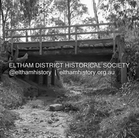
Negative - Photograph, J.A. McDonald, Heidelberg-Kinglake Road, Sep. 1959
Job 56M Contractor Hillgrove Looking downstream under bridge Ironbark Gully September 1959Record of various Shire of Eltham infrastructure works undertaken during the period of 1952-1962 involving bridge and road reconstruction projects, sometimes with Eltham Shire Council Project Reference numbers quoted. It was during this period that a number of significant improvements were made to roads and new bridges constructed within the shire that remain in place as of present day (2022). In many situations, the photos provide a tangible visible record of infrastructure that existed throughout the early days of the Shire. The album was put together by or under the direction of the Shire Engineer, J.A. McDonald.infrastructure, shire of eltham, bridge construction, 1959-09, heidelberg-kinglake road -
 Eltham District Historical Society Inc
Negative - Photograph, J.A. McDonald, Henley Road at Watsons Creek, Mar. 1961
Old bridge over Watsons Creek 22 March 1961 Cr. Pelling and Contractor WolfRecord of various Shire of Eltham infrastructure works undertaken during the period of 1952-1962 involving bridge and road reconstruction projects, sometimes with Eltham Shire Council Project Reference numbers quoted. It was during this period that a number of significant improvements were made to roads and new bridges constructed within the shire that remain in place as of present day (2022). In many situations, the photos provide a tangible visible record of infrastructure that existed throughout the early days of the Shire. The album was put together by or under the direction of the Shire Engineer, J.A. McDonald.infrastructure, shire of eltham, 1961-03, bend of islands, cr. charis pelling, henley road, henley road bridge, kangaroo ground, oxley bridge, watsons creek, w.e. wolf, bridge construction, road construction -
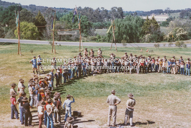 Eltham District Historical Society Inc
Photograph - Colour Print, Lewis Tulk, Eltham District Scout Camp, Eltham Town Park, c.1982
Bridge Street in background. Donated by Lewis Tulk, former Scout Area Training Commisioner for Leaders.scouts victoria, scout leader training, lewis tulk collection, yarra batman area, alistair knox park, eltham district scout camp, eltham town park, bridge street -
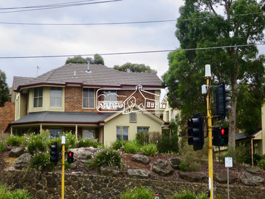 Eltham District Historical Society Inc
Photograph, Jim Connor, Main Road, Eltham, 14 Jan 2017
Eltham Gateway, Unit complex at 72-74 Bridge Street, Eltham at corner of Main RoadTomorrow's history documented todayeltham, jim connor collection, main road, eltham gateway, bridge street -
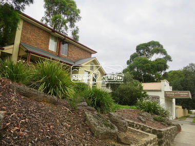 Eltham District Historical Society Inc
Photograph, Jim Connor, Main Road, Eltham, 14 Jan 2017
Eltham Gateway, Unit complex at 72-74 Bridge Street, Eltham at corner of Main RoadTomorrow's history documented todayeltham, jim connor collection, main road, eltham gateway, bridge street -
 Eltham District Historical Society Inc
Photograph, Jim Connor, Main Road, Eltham, 14 Jan 2017
Eltham Gateway, Unit complex at 72-74 Bridge Street, Eltham at corner of Main RoadTomorrow's history documented todayeltham, jim connor collection, main road, eltham gateway -
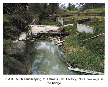 Eltham District Historical Society Inc
Work on paper (Sub-Item) - Photograph, Landscaping at Latiners Hat Factory
Colour photograph of Landscaping at Latiners Hat Factory, Sherbourne Road, Eltham. Note blockage at the bridgeeltham, drain, latiners, hat factory, landscaping, footbridge, blockage -
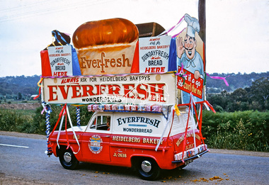 Eltham District Historical Society Inc
Photograph, Heidelberg Bakery display, Ersilac Parade, Main Road, Eltham, c.1960, 1960c
Heading south along Main Road approaching Bridge Street. Registration GIB is c.1955Digital file only (Wes's 35mm)don muir collection, heidelberg bakery display, ersilac parade, main road, eltham, c.1960 -
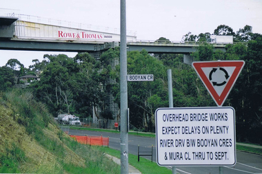 Greensborough Historical Society
Photograph - Digital image, Frank Solomon, Plenty River Drive roadworks 2, 2005c
These photos show the duplication of the bridge over Plenty River Drive on the Greensborough Bypass, circa 2005.Digital copy of colour photographplenty river drive, greensborough bypass -
 Eltham District Historical Society Inc
Photograph, Russell Yeoman, Construction of fire access on Gumtree Road, Research, by Army Reserve Engineers under command of Captain Bill Oakley, c.1966, 1966c
Bill Oakley was an engineer at the Shire of Eltham. Bill Oakley indicating the rough span of the proposed bridge. Digital file only; created from original colour positive slide transparencyresearch (vic.), russell yeoman collection, gumtree road, army reserve engineers, captain bill oakley, fc holden sedan, fire access, streets, bill oakley -
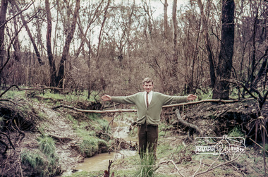
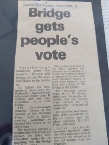 Peterborough History Group
Article - Bridge gets people's vote, Cobden Times, 1985
Peterborough Citizen's Group held a meeting to ascertain support for retention of the old bridge, and how to proceed.Appreciation of old bridge and the efforts conducted in order to keep all or part of the bridge, once the new bridge was built. Short two column article from The Standard, Tuesday July 1985peterborough, peterborough old bridge, curdies river bridge -
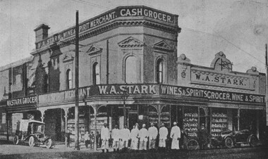 City of Ballarat Libraries
Photograph - Card Box Photographs, W.A. Stark's Grocer, Wine & Spirits Merchant Store 1916. From Citizens & Sport publication
Located on the corner of Bridge and Peel Streets. 8 staff stand on the footpath. Large display windows. w.a. stark, commericial, building, bridge street, peel street, people, vehicle -
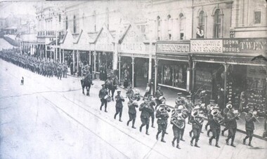 City of Ballarat Libraries
Photograph - Card Box Photographs, Military Parade, Ballarat
Soldiers march down Bridge Street past Tylers Store. Possibly First World War.military, parade, bridge street, tylers store -
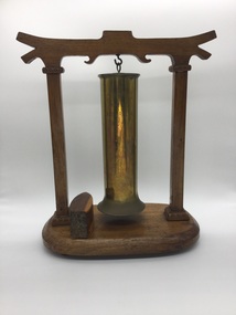 Wonthaggi RSL
Trench Art, Circa 1917
Wooden Art Piece & Artillary Shell - hung by standing frame and an asian designed bridge piece Object potentially used in meetings and ceremoniesCustomised navel shell casing, hung on wooden frame, accompanied by wooden striker. HMAS AUSTRALIA, 1913 - 21 Various - Manufactures Markshmas australia, trenchart - 1917 -
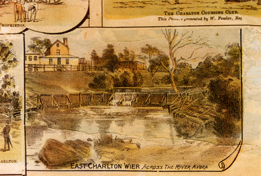 Charlton Golden Grains Museum Inc
Photograph - Lithograph, Rider & Mercer, Views of Charlton
East Charlton weir across the Avoca River about 60 metres upstream from Bridge.Colour photograph of a portion of the "Views of Charlton" Lithograph. The photo is a close up of the East Charlton Wier portion of the Lithograph.East Charlton Wier Across the River Avoca.charlton, lithograph, charlton weir, avoca river, flour mill, foreman, avoca water works trust