Showing 11018 items matching " land"
-
 Federation University Historical Collection
Instrument - Survey Chain, Chesterman, Gunter's Survey Chain
Before metric measurement was introduced land was measured in chains and links. The chain was a precision part of a surveyor's equipment. It required frequent calibration, yet needed to be sturdy enough to be dragged through rough terrain for years. A standard survey chain is 66 feet (or 20.117m) long and made up of 100 links. Each link is 7.92 inches (approximately 201mm) long, measured from the inside of the loop. The handles are for tensioning the chain in use, they are not part of the length of the chain. In pre-metric units, there were 80 chains to 1 mile (equals 1.609km) This surveyor’s chain has an 8-inch link pitch, with markers at 10 link intervals. This metal surveyor’s chain (or Gunter's Chain) has an 8-inch link pitch, with markers at 10 link intervals, and handles at either end. A Surveyor’s Chain was 66 feet long, and made up of 100 links connected by two rings. A link in measurement includes the two rings at each end. gunter's chain, survey chain, surveyor s chain, perch, rood, surveying -
 Eltham District Historical Society Inc
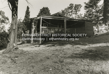
Photograph, Fay Bridge, Clifton Pugh's Artists' Colony, Dunmoochin, Barreenong Road, Cottles Bridge, c.1995
Visit to Dunmoochin prior to Clifton Pugh's home being destroyed by fire in 2002. Following military service in the second world war, Clifton Pugh studied under artist Sir William Dargie at the National Gallery School in Melbourne as well as Justus Jorgensen, founder of Montsalvat. For a while he lived on the dole but also worked packing eggs for the Belot family saving sufficient to purchase six acres (2.4 ha) of land at Barreenong Road, Cottles Bridge. He accumulated more land and persuaded several other artists and friends to buy land nearby, resulting in a property of approximately 200 acres, stablishing it as one of the first artistic communes in Australia alongside Montsalvat in Eltham. It was around 1951 that Pugh felt he had '"done moochin' around" and so the name of the property evolved. He bought timber from Alistair Knox to build his house on the crest of a hill. Inspired by local goldminer's huts, it was a one room wattle-and-daub structure with dirt floor. Over the years it expanded with thick adobe walls made from local clay, high ceilings and stone floors. All materials other than the local earth were sourced from second hand materials, most found at wreckers' yards. Artists from across the nation were drawn to Dunmoochin, with several setting up houses and shacks on the property, maintaining their independence but sharing their artistic zeal. Artists who worked or resided at Dunmoochin included Mirka Mora, John Perceval, Albert Tucker, Fred Williams, Charles Blackman, Arthur Boyd and John Olsen. In 2002, Pugh's house along with its treasure trove of art and a library of some 20,000 books was destroyed by fire. Traces of Pugh's home remain with the presence of the Victorian doorframe archway with leadlight of intricate design, procured from a demolished Melbourne mansion; and two bronze life-sized female statues created by Pugh and cast by Matcham Skipper. In place of Pugh's house rose two double-storey mud-brick artists' studios topped with corrugated iron rooves curved like the wings of a bird with accommodation for seven. The original studios, gallery and other buildings survived the fire.fay bridge collection, 1995, barreenong road, cottles bridge, dunmoochin -
 Eltham District Historical Society Inc
Opening of Meruka Childcare Co-operative, Meruka Park, 5 Meruka Dr, Eltham, April 1994
In 1919 J.B. North, a violinist with the then Melbourne Symphonic Orchestra, and Monsieur Leon Lambert, a French architect, who later designed the Glaciarium Ice Skating Rink, purchased three available farms, Looker's, Wright's and Taylor's, approximately 60 acres, the area running along the creek and being bordered by the present day Ryans Road, Karingal Drive and Sherbourne Road. The farms were used for orchards and market gardens. Leon Lambert designed and built two homes on the farm site, one for the North family, ‘Tralford’, and the other, ‘Glen Ellen’, for himself and his wife. The homes were considered as "brother and sister" and they each included in their design an identical bay window in the main living area. "Glen Ellen" originally comprised kitchen, lounge room, inglenook, dining room, bath room and sleepout. Although the home has been extended over the years, much of the original architecture has been retained including timber panelling and three fireplaces. The land was subdivided in approximately 1966 with "Glen Ellen" retaining approximately one half acre of land fronting Meruka Drive. The property then passed from the Charleston family to Gerald and Margaret Sutton in 1976 and again was sold in 1980 and lastly sold again in 1994. The Norths named their house 'Tralford'. According to Marjorie North, the name Meruka was suggested by Alan Gardner and so was apparently not used by the North family. The name appears to be of Indian origin and its connection with the land is not known. ‘Tralford’ stayed in the North family for many years. Eltham Council acquired the house to create Meruka Park. The house was used for some years by the Council as a community arts facility and as emergency accommodation. It fell into disrepair and was demolished about 1990. The Meruka Child Care Centre has been built on the site and incorporates some of the architectural features of the old house. The Co-op was opened in April 1994. The original drive flanked by large old cypress trees remains. These trees are considered to be of local heritage significance and for this reason Meruka Park is covered by a Heritage Overlay under the Nillumbik Planning Scheme. Part of the park has been preserved as habitat for rare local flora. LL's house, named ‘Glen Ellen’, remains in a well-preserved state and fronts Meruka Drive.cr pam sladden, eltham, meruka child care co-operative, meruka house, meruka park -
 Eltham District Historical Society Inc
Opening of Meruka Childcare Co-operative, Meruka Park, 5 Meruka Dr, Eltham, April 1994
In 1919 J.B. North, a violinist with the then Melbourne Symphonic Orchestra, and Monsieur Leon Lambert, a French architect, who later designed the Glaciarium Ice Skating Rink, purchased three available farms, Looker's, Wright's and Taylor's, approximately 60 acres, the area running along the creek and being bordered by the present day Ryans Road, Karingal Drive and Sherbourne Road. The farms were used for orchards and market gardens. Leon Lambert designed and built two homes on the farm site, one for the North family, ‘Tralford’, and the other, ‘Glen Ellen’, for himself and his wife. The homes were considered as "brother and sister" and they each included in their design an identical bay window in the main living area. "Glen Ellen" originally comprised kitchen, lounge room, inglenook, dining room, bath room and sleepout. Although the home has been extended over the years, much of the original architecture has been retained including timber panelling and three fireplaces. The land was subdivided in approximately 1966 with "Glen Ellen" retaining approximately one half acre of land fronting Meruka Drive. The property then passed from the Charleston family to Gerald and Margaret Sutton in 1976 and again was sold in 1980 and lastly sold again in 1994. The Norths named their house 'Tralford'. According to Marjorie North, the name Meruka was suggested by Alan Gardner and so was apparently not used by the North family. The name appears to be of Indian origin and its connection with the land is not known. ‘Tralford’ stayed in the North family for many years. Eltham Council acquired the house to create Meruka Park. The house was used for some years by the Council as a community arts facility and as emergency accommodation. It fell into disrepair and was demolished about 1990. The Meruka Child Care Centre has been built on the site and incorporates some of the architectural features of the old house. The Co-op was opened in April 1994. The original drive flanked by large old cypress trees remains. These trees are considered to be of local heritage significance and for this reason Meruka Park is covered by a Heritage Overlay under the Nillumbik Planning Scheme. Part of the park has been preserved as habitat for rare local flora. LL's house, named ‘Glen Ellen’, remains in a well-preserved state and fronts Meruka Drive.eltham, meruka child care co-operative, meruka house, meruka park, cr. peter graham, peter staples, richard allen, sheryl garbutt, bill penrose -
 Eltham District Historical Society Inc
Opening of Meruka Childcare Co-operative, Meruka Park, 5 Meruka Dr, Eltham, April 1994
In 1919 J.B. North, a violinist with the then Melbourne Symphonic Orchestra, and Monsieur Leon Lambert, a French architect, who later designed the Glaciarium Ice Skating Rink, purchased three available farms, Looker's, Wright's and Taylor's, approximately 60 acres, the area running along the creek and being bordered by the present day Ryans Road, Karingal Drive and Sherbourne Road. The farms were used for orchards and market gardens. Leon Lambert designed and built two homes on the farm site, one for the North family, ‘Tralford’, and the other, ‘Glen Ellen’, for himself and his wife. The homes were considered as "brother and sister" and they each included in their design an identical bay window in the main living area. "Glen Ellen" originally comprised kitchen, lounge room, inglenook, dining room, bath room and sleepout. Although the home has been extended over the years, much of the original architecture has been retained including timber panelling and three fireplaces. The land was subdivided in approximately 1966 with "Glen Ellen" retaining approximately one half acre of land fronting Meruka Drive. The property then passed from the Charleston family to Gerald and Margaret Sutton in 1976 and again was sold in 1980 and lastly sold again in 1994. The Norths named their house 'Tralford'. According to Marjorie North, the name Meruka was suggested by Alan Gardner and so was apparently not used by the North family. The name appears to be of Indian origin and its connection with the land is not known. ‘Tralford’ stayed in the North family for many years. Eltham Council acquired the house to create Meruka Park. The house was used for some years by the Council as a community arts facility and as emergency accommodation. It fell into disrepair and was demolished about 1990. The Meruka Child Care Centre has been built on the site and incorporates some of the architectural features of the old house. The Co-op was opened in April 1994. The original drive flanked by large old cypress trees remains. These trees are considered to be of local heritage significance and for this reason Meruka Park is covered by a Heritage Overlay under the Nillumbik Planning Scheme. Part of the park has been preserved as habitat for rare local flora. LL's house, named ‘Glen Ellen’, remains in a well-preserved state and fronts Meruka Drive.eltham, meruka child care co-operative, meruka house, meruka park, cr. john cohen -
 Eltham District Historical Society Inc
Opening of Meruka Childcare Co-operative, Meruka Park, 5 Meruka Dr, Eltham, April 1994
In 1919 J.B. North, a violinist with the then Melbourne Symphonic Orchestra, and Monsieur Leon Lambert, a French architect, who later designed the Glaciarium Ice Skating Rink, purchased three available farms, Looker's, Wright's and Taylor's, approximately 60 acres, the area running along the creek and being bordered by the present day Ryans Road, Karingal Drive and Sherbourne Road. The farms were used for orchards and market gardens. Leon Lambert designed and built two homes on the farm site, one for the North family, ‘Tralford’, and the other, ‘Glen Ellen’, for himself and his wife. The homes were considered as "brother and sister" and they each included in their design an identical bay window in the main living area. "Glen Ellen" originally comprised kitchen, lounge room, inglenook, dining room, bath room and sleepout. Although the home has been extended over the years, much of the original architecture has been retained including timber panelling and three fireplaces. The land was subdivided in approximately 1966 with "Glen Ellen" retaining approximately one half acre of land fronting Meruka Drive. The property then passed from the Charleston family to Gerald and Margaret Sutton in 1976 and again was sold in 1980 and lastly sold again in 1994. The Norths named their house 'Tralford'. According to Marjorie North, the name Meruka was suggested by Alan Gardner and so was apparently not used by the North family. The name appears to be of Indian origin and its connection with the land is not known. ‘Tralford’ stayed in the North family for many years. Eltham Council acquired the house to create Meruka Park. The house was used for some years by the Council as a community arts facility and as emergency accommodation. It fell into disrepair and was demolished about 1990. The Meruka Child Care Centre has been built on the site and incorporates some of the architectural features of the old house. The Co-op was opened in April 1994. The original drive flanked by large old cypress trees remains. These trees are considered to be of local heritage significance and for this reason Meruka Park is covered by a Heritage Overlay under the Nillumbik Planning Scheme. Part of the park has been preserved as habitat for rare local flora. LL's house, named ‘Glen Ellen’, remains in a well-preserved state and fronts Meruka Drive.eltham, meruka child care co-operative, meruka house, meruka park, rob hauser -
 Eltham District Historical Society Inc
Opening of Meruka Childcare Co-operative, Meruka Park, 5 Meruka Dr, Eltham, April 1994
In 1919 J.B. North, a violinist with the then Melbourne Symphonic Orchestra, and Monsieur Leon Lambert, a French architect, who later designed the Glaciarium Ice Skating Rink, purchased three available farms, Looker's, Wright's and Taylor's, approximately 60 acres, the area running along the creek and being bordered by the present day Ryans Road, Karingal Drive and Sherbourne Road. The farms were used for orchards and market gardens. Leon Lambert designed and built two homes on the farm site, one for the North family, ‘Tralford’, and the other, ‘Glen Ellen’, for himself and his wife. The homes were considered as "brother and sister" and they each included in their design an identical bay window in the main living area. "Glen Ellen" originally comprised kitchen, lounge room, inglenook, dining room, bath room and sleepout. Although the home has been extended over the years, much of the original architecture has been retained including timber panelling and three fireplaces. The land was subdivided in approximately 1966 with "Glen Ellen" retaining approximately one half acre of land fronting Meruka Drive. The property then passed from the Charleston family to Gerald and Margaret Sutton in 1976 and again was sold in 1980 and lastly sold again in 1994. The Norths named their house 'Tralford'. According to Marjorie North, the name Meruka was suggested by Alan Gardner and so was apparently not used by the North family. The name appears to be of Indian origin and its connection with the land is not known. ‘Tralford’ stayed in the North family for many years. Eltham Council acquired the house to create Meruka Park. The house was used for some years by the Council as a community arts facility and as emergency accommodation. It fell into disrepair and was demolished about 1990. The Meruka Child Care Centre has been built on the site and incorporates some of the architectural features of the old house. The Co-op was opened in April 1994. The original drive flanked by large old cypress trees remains. These trees are considered to be of local heritage significance and for this reason Meruka Park is covered by a Heritage Overlay under the Nillumbik Planning Scheme. Part of the park has been preserved as habitat for rare local flora. LL's house, named ‘Glen Ellen’, remains in a well-preserved state and fronts Meruka Drive.eltham, meruka child care co-operative, meruka house, meruka park, irene bogle -
 Eltham District Historical Society Inc
Opening of Meruka Childcare Co-operative, Meruka Park, 5 Meruka Dr, Eltham, April 1994
In 1919 J.B. North, a violinist with the then Melbourne Symphonic Orchestra, and Monsieur Leon Lambert, a French architect, who later designed the Glaciarium Ice Skating Rink, purchased three available farms, Looker's, Wright's and Taylor's, approximately 60 acres, the area running along the creek and being bordered by the present day Ryans Road, Karingal Drive and Sherbourne Road. The farms were used for orchards and market gardens. Leon Lambert designed and built two homes on the farm site, one for the North family, ‘Tralford’, and the other, ‘Glen Ellen’, for himself and his wife. The homes were considered as "brother and sister" and they each included in their design an identical bay window in the main living area. "Glen Ellen" originally comprised kitchen, lounge room, inglenook, dining room, bath room and sleepout. Although the home has been extended over the years, much of the original architecture has been retained including timber panelling and three fireplaces. The land was subdivided in approximately 1966 with "Glen Ellen" retaining approximately one half acre of land fronting Meruka Drive. The property then passed from the Charleston family to Gerald and Margaret Sutton in 1976 and again was sold in 1980 and lastly sold again in 1994. The Norths named their house 'Tralford'. According to Marjorie North, the name Meruka was suggested by Alan Gardner and so was apparently not used by the North family. The name appears to be of Indian origin and its connection with the land is not known. ‘Tralford’ stayed in the North family for many years. Eltham Council acquired the house to create Meruka Park. The house was used for some years by the Council as a community arts facility and as emergency accommodation. It fell into disrepair and was demolished about 1990. The Meruka Child Care Centre has been built on the site and incorporates some of the architectural features of the old house. The Co-op was opened in April 1994. The original drive flanked by large old cypress trees remains. These trees are considered to be of local heritage significance and for this reason Meruka Park is covered by a Heritage Overlay under the Nillumbik Planning Scheme. Part of the park has been preserved as habitat for rare local flora. LL's house, named ‘Glen Ellen’, remains in a well-preserved state and fronts Meruka Drive.eltham, meruka child care co-operative, meruka house, meruka park, cr bob manuell, matthew rodscholler -
 Eltham District Historical Society Inc
Opening of Meruka Childcare Co-operative, Meruka Park, 5 Meruka Dr, Eltham, April 1994
In 1919 J.B. North, a violinist with the then Melbourne Symphonic Orchestra, and Monsieur Leon Lambert, a French architect, who later designed the Glaciarium Ice Skating Rink, purchased three available farms, Looker's, Wright's and Taylor's, approximately 60 acres, the area running along the creek and being bordered by the present day Ryans Road, Karingal Drive and Sherbourne Road. The farms were used for orchards and market gardens. Leon Lambert designed and built two homes on the farm site, one for the North family, ‘Tralford’, and the other, ‘Glen Ellen’, for himself and his wife. The homes were considered as "brother and sister" and they each included in their design an identical bay window in the main living area. "Glen Ellen" originally comprised kitchen, lounge room, inglenook, dining room, bath room and sleepout. Although the home has been extended over the years, much of the original architecture has been retained including timber panelling and three fireplaces. The land was subdivided in approximately 1966 with "Glen Ellen" retaining approximately one half acre of land fronting Meruka Drive. The property then passed from the Charleston family to Gerald and Margaret Sutton in 1976 and again was sold in 1980 and lastly sold again in 1994. The Norths named their house 'Tralford'. According to Marjorie North, the name Meruka was suggested by Alan Gardner and so was apparently not used by the North family. The name appears to be of Indian origin and its connection with the land is not known. ‘Tralford’ stayed in the North family for many years. Eltham Council acquired the house to create Meruka Park. The house was used for some years by the Council as a community arts facility and as emergency accommodation. It fell into disrepair and was demolished about 1990. The Meruka Child Care Centre has been built on the site and incorporates some of the architectural features of the old house. The Co-op was opened in April 1994. The original drive flanked by large old cypress trees remains. These trees are considered to be of local heritage significance and for this reason Meruka Park is covered by a Heritage Overlay under the Nillumbik Planning Scheme. Part of the park has been preserved as habitat for rare local flora. LL's house, named ‘Glen Ellen’, remains in a well-preserved state and fronts Meruka Drive.eltham, meruka child care co-operative, meruka house, meruka park, cr pam sladden, mandy press -
 City of Moorabbin Historical Society (Operating the Box Cottage Museum)
Photograph - Photographs of Highett Gasworks, Gasometer, Retort House and Coal Store at Highett Gasworks, 1974 and 1960
Gasometers resulted from complex engineering design evolving from primitive gasholders first used in 1824 in England to power street lights. The 20th century gasometer, (as used at the Highett Gasworks), was comprised of a series of large interconnected, telescopic, cylindrical vessels or lifts, which rose and fell depending on the volume of gas stored. The gasholder operated on a basic principle of a gas-filled floating vessel, rising and falling in a seal of water. The Highett Gasworks had its beginning in 1939 but its beginnings commenced sixty-two years earlier when the privately owned Brighton Gas Company was floated in 1877. By 1880 the company was performing well and making excellent profits. The company was welcomed by residents wanting to replace the shadowy light of a kerosene lamp with the bright luminescence of "modern" gas lamps. The land developers of the day were also keen supporters. But by 1884 people became disgrunted because either the gas had not reached them yet or because the quality of the supply had diminished due to the increasing use. In 1885 a second private gas company, the Central Brighton and Moorabbin Gas Co, Chaired by "Tommy" Bent was floated and for many years the two gas companies enjoyed a shared monopoly in supplying gas from their New Street Works. In the 1930s the company expanded its gas production facilities to Highett where it had purchased 45 acres of land adjacent to the Melbourne-Frankston railway line. A gasholder with a capacity of 750,000 cubic feet was erected on the Highett land in 1927 and connected with high pressure mains to the Brighton works. Three years later the company directors decided to proceed with the construction of a vertical retort house and coal store. Following a "lull" during the Great Depression work recommenced in 1936 and by 1939 the first complete gas-making plant was completed, and gas making commenced. Over the next twenty one years other significant extensions occurred, including an amenities block to accomodate 100 workers. In 1969 Esso commenced the introduction of natural gas to residents homes and the gradual decommissioning of the Highett Gasworks commenced. Part of the old Highett Gasworks site is now a council owned parkThe photos of the Higett Gasworks, now demolished, recall their long history, that originated in the 1800s with the production of gas to supply homes with a new, much improved light source, and later it's other applications such as for stoves etc. The arrival of gas in the Shire of Moorabbin was a huge step forward that encouraged further building and development in the area.Three Photographs of the Highett Gasworks. Two are coloured photos taken in 1974, and one is black and white taken in the 1960s. All are in good conditionOn the back of the two coloured photographs "Highett Gasworks 1974" No inscription on the black and white aerial photograph.brighton, moorabbin, highett, bent thomas, gasometer, highett gasworks, engineering design, brighton gas company, central brighton and moorabbin gas company, great depression, lamp kerosene -
 Eltham District Historical Society Inc
Photograph - Black and White Print, Shire of Eltham, Meruka Child Care Centre, turning the first sod: Cr Pamela Sladden, Peter Staples MHR Jaga Jaga, c.1993
In 1919 J.B. North, a violinist with the then Melbourne Symphonic Orchestra, and Monsieur Leon Lambert, a French architect, who later designed the Glaciarium Ice Skating Rink, purchased three available farms, Looker's, Wright's and Taylor's, approximately 60 acres, the area running along the creek and being bordered by the present day Ryans Road, Karingal Drive and Sherbourne Road. The farms were used for orchards and market gardens. Leon Lambert designed and built two homes on the farm site, one for the North family, ‘Tralford’, and the other, ‘Glen Ellen’, for himself and his wife. The homes were considered as "brother and sister" and they each included in their design an identical bay window in the main living area. "Glen Ellen" originally comprised kitchen, lounge room, inglenook, dining room, bath room and sleepout. Although the home has been extended over the years, much of the original architecture has been retained including timber panelling and three fireplaces. The land was subdivided in approximately 1966 with "Glen Ellen" retaining approximately one half acre of land fronting Meruka Drive. The property then passed from the Charleston family to Gerald and Margaret Sutton in 1976 and again was sold in 1980 and lastly sold again in 1994. The Norths named their house 'Tralford'. According to Marjorie North, the name Meruka was suggested by Alan Gardner and so was apparently not used by the North family. The name appears to be of Indian origin and its connection with the land is not known. ‘Tralford’ stayed in the North family for many years. Eltham Council acquired the house to create Meruka Park. The house was used for some years by the Council as a community arts facility and as emergency accommodation. It fell into disrepair and was demolished about 1990. The Meruka Child Care Centre has been built on the site and incorporates some of the architectural features of the old house. The Co-op was opened in April 1994. The original drive flanked by large old cypress trees remains. These trees are considered to be of local heritage significance and for this reason Meruka Park is covered by a Heritage Overlay under the Nillumbik Planning Scheme. Part of the park has been preserved as habitat for rare local flora. LL's house, named ‘Glen Ellen’, remains in a well-preserved state and fronts Meruka Drive.shire of eltham archives, child care centres, health & community services, meruka child care co-operative, peter staples mhr jaga jaga, cr pamela sladden -
 Eltham District Historical Society Inc
Photograph - Black and White Print, Shire of Eltham, Meruka Child Care Centre, Eltham, c.1994
In 1919 J.B. North, a violinist with the then Melbourne Symphonic Orchestra, and Monsieur Leon Lambert, a French architect, who later designed the Glaciarium Ice Skating Rink, purchased three available farms, Looker's, Wright's and Taylor's, approximately 60 acres, the area running along the creek and being bordered by the present day Ryans Road, Karingal Drive and Sherbourne Road. The farms were used for orchards and market gardens. Leon Lambert designed and built two homes on the farm site, one for the North family, ‘Tralford’, and the other, ‘Glen Ellen’, for himself and his wife. The homes were considered as "brother and sister" and they each included in their design an identical bay window in the main living area. "Glen Ellen" originally comprised kitchen, lounge room, inglenook, dining room, bath room and sleepout. Although the home has been extended over the years, much of the original architecture has been retained including timber panelling and three fireplaces. The land was subdivided in approximately 1966 with "Glen Ellen" retaining approximately one half acre of land fronting Meruka Drive. The property then passed from the Charleston family to Gerald and Margaret Sutton in 1976 and again was sold in 1980 and lastly sold again in 1994. The Norths named their house 'Tralford'. According to Marjorie North, the name Meruka was suggested by Alan Gardner and so was apparently not used by the North family. The name appears to be of Indian origin and its connection with the land is not known. ‘Tralford’ stayed in the North family for many years. Eltham Council acquired the house to create Meruka Park. The house was used for some years by the Council as a community arts facility and as emergency accommodation. It fell into disrepair and was demolished about 1990. The Meruka Child Care Centre has been built on the site and incorporates some of the architectural features of the old house. The Co-op was opened in April 1994. The original drive flanked by large old cypress trees remains. These trees are considered to be of local heritage significance and for this reason Meruka Park is covered by a Heritage Overlay under the Nillumbik Planning Scheme. Part of the park has been preserved as habitat for rare local flora. LL's house, named ‘Glen Ellen’, remains in a well-preserved state and fronts Meruka Drive.shire of eltham archives, child care centres, health & community services, meruka child care co-operative -
![Diary, [Digital file].1840-1841. Charles Griffith](/media/collectors/5e461d8021ea67224c82f2a1/items/67a209aff435c92f9910fa93/item-media/67a20ae0f435c92f9910fc3e/item-fit-380x285.jpg) Bacchus Marsh & District Historical Society
Bacchus Marsh & District Historical SocietyDiary, [Digital file].1840-1841. Charles Griffith
Charles Griffith was born in Kildare, Ireland in 1808. He studied at Trinity College, Dublin acquiring a B.A. in 1829 and an M.A. in 1832 before being admitted to practice as barister. In 1840 he emigrated to Australia arriving in the Port Phillip District in November 1840. Soon after arriving he and his friend James Moore formed a business partnership and acquired land in the Parwan Valley near Bacchus Marsh. This land had been in the possession of a Mr. McKenzie who agreed to sell his land and sheep to Griffith and Moore. The property they acquired came to be known as Glenmore. The partnership with James Moore lasted until 1848. In 1846, whilst in Ireland, Griffith married Miss Jane Catherine Magee, then returned to Glenmore and later took his nephew, Molesworth Richard Greene, into partnership, which arrangement proved to be long and prosperous. In 1857, they bought runs at Mount Hope and Mount Pyramid, which they kept until the days of free selection. Griffith led an active and successful public life. He was a member of the new Victorian Legislative Council in 1851, and was later an elected representative of the Legislative Assembly 1853-1859. He occupied many important public positions, including that of magistrate for Bacchus Marsh. Griffith was a devout Anglican and hosted Bishop Charles Perry at his station near Bacchus Marsh in 1849. He died in 1863 at his home in South Yarra. The diary is a detailed account of Griffith's voyage from Ireland to Australia and of his early months in Melbourne. After this it covers his early months establishing himself on his property, Glenmore, near Bacchus Marsh. The timeline of the diary stretches across 1840 and 1841. Griffith was an educated gentleman who made detailed observations about the environment he found himself in. The diary is particularly notable for Griffith's commentary about his interactions with people from first nations, and reveals some of his thinking about Colonial policies directed at first nations people. The diary also includes some sketches of individual first nations people along with some sketches of flora and fauna. The final part of the diary includes a glossary of Aboriginal words Griffith was familiar with. Digital file. PDF format. Digitised by State Library Victoria from photocopied pages of a hand-written transcription of the original diaries written by Charles J. (James) Griffith in 1840 and 1841.charles james griffith 1808-1863, diaries bacchus marsh, glenmore station, wadawurrung people, aboriginal australians bacchus marsh region history -
 Federation University Historical Collection
Document - Documents, Golden Point - Mount Pleasant Progress Association Establishment
The Golden Point - Mt Pleasant Progress Association was established on Wednesday 6 April 1983. Membership was open to any person or organisation in the area generally bounded by Bridge mall and Skipton Street, Elsworth Street and main Road. annual family or organisation membership was $2.00. Mara Gluyas served as secretary of the Golden Point - Mt Pleasant Progress Association from 1983 to 1994. Ian McKinnon was the President from 1983 to 1992. Kerry Daniels was the President in 1994.A small white cardboard box with purple lid of A4 documents relating to the establishment of the Golden Point - Mt Pleasant Progress Association. The documents include the original constitution and minutes. Topics include: Pearce's Park; removal of elms, names and addresses of members, Sovereign Hill realignment; Sovereign Hill Lookout; membership form; Golden Point Historic Mines Direction Indicator; Ballarat Observatory; Nerrina Tip; Yarrowee Creek; Mine Capping (Sovereign Mine); tree planting (Sovereign Hill Lookout); Magpie Street Park; Hill Street; Yarrowee Flora Park; Barkly Street; South Street Bluestone Gutter; Ballarat Goldfields; Eastern baths site; Grant Street; Flooding; Aboriginal Advancement League; Sunnyside Woollen Mill; Chinese Garden; Golden Point Primary School closure; Ballarat West Goldfields; Sovereign Hill Land Title and Management Revision; Wainwright; Street; Llanberris; Yuille's Station Parkgolden point, mount pleasant, mt pleasant, ian mckinnno, mara gluyas, peter hiscock, frank williams, geoff howard, leigh gillett, sovereign hill, kerry daniels, norm strange; graeme kent; george netherway; keith rash; ian mckinnon, albert graham, bryan crebbin, jim humphreys. wid radbourn, heath martin, janet dore, alex mills park -
 Bendigo Historical Society Inc.
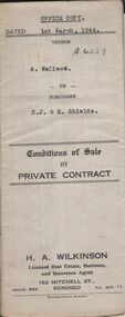
Document - H.A. & S.R. WILKINSON COLLECTION: CONTRACT OF SALE
Conditions of sale by private contract dated 1st March, 1944 between A. Wallace (seller) and R.J. & E. Shields (buyer) for land situate in Ellis Street, Kennington containing six acres being described in certificate of title volume 4983 folio 995671 section H and being Crown allotments 529,529A, 529B. Crown grant volume 6111 folio 1222194, crown allotments 530, 530A section H. Crown grant volume 6307 folio 1261328, Crown allotment 529F section H. Crown grant volume 6307 folio 1261329, Crown allotment 529C section H. Crown grant volume 6307 folio 1261293, crown allotment 529D section H. Crown grant volume 6307 folio 1261294 crown allotment 529E section H. Together with 6-roomed weatherboard dwelling and all sundry. Price 1,300 pounds.organization, business, h.a. & s.r wilkinson real estate -
 Bendigo Historical Society Inc.
Document - H. A. & S. R. WILKINSON COLLECTION: CONTRACT OF SALE
Contract of sale dated 27th March, 1958 between Mr. V. V. & Mrs R. M. Wodetzki (vendor) and Mr. L. J. & Mrs. T. M. Pascoe (purchaser). Solicitor for vendor: Watson, James & Rogers, Bull Street, Bendigo. Solicitor for purchaser: Watson, James & Rogers, Bull Street, Bendigo. Property 4 Malcom Street, Bendigo being lot 5 on plan of subdivision No. 22158(?) lodged in the office of titles and being part of Crown allotment8 and 9 section 165C land described in certificate of title volume 7597 folio 005(?), together with all floor coverings, blinds, curtains, electric light fittings and shades with the exception of crystal hade in the hall. "Shor" washing machine, "Masters" early electric stove. Price: 6,200 pounds. Attached Statement pursuant to section 34 of the estate agents act 1956 and 4 hand written notes.organization, business, h.a. & s.r wilkinson real estate -
 Bendigo Historical Society Inc.
Document - DEBORAH REEF PROJECT ENVIRONMENT EFFECTS STATEMENT
Two page document. On top, first page ' Bendigo Mining N.L., Deborah Reef Project, Environment Effects Statement, Summary Brochure'. Poppet head on top LH corner of document. A map of central Bendigo is drawn on page 1 and shows the location of the proposed processing plant near the Airport. Further maps on page 2 and 3 show the North Deborah Mine Site, the pipeline route and the airfield site. The summary brochure provides an outline of the material contained in the Environment Effects Statement and proposed planning scheme amendments upon which, the Deborah Reef Project will be assessed. Page four lists the issues that impact on this submission: planning and land use; socio economic environment; traffic; discharges to air; water management; explosives storage and handling; subsidence; heritage; flora and fauna and landscape and visual assessment. The 16th March, 1989, is the date given for submissions to be lodged in regard to this project.Bendigo Mining N.Lbendigo, mining, deborah reef project -
 Bendigo Historical Society Inc.
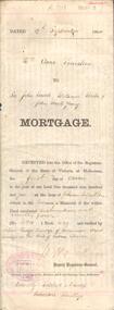
Document - CONSTABLE JOHN BARRY COLLECTION: MEMORANDUM OF EQUITABLE MORTGAGE
Handwriten document, Memorandum: 13th day of May, 1884, 'relating to a portion of land situate at McIvor road, Sandhurst in the colony of Victoria a list thereof is contained in the schedule hereto delivered by me Jane Anderson of McIvor Road Sandhurst, aforesaid widow to Thomas Jeffeson Connelly of Sandhurst aforesaid solicitor in pledge to secure to the aforesaid Thomas Jefferson Connelly the sum of twenty two pounds' Schedule referred to: Conveyance: R.I. Adworth to William Andersn , dated 3rd day of march 1862. Conveyance: William Anderson to Jane Anderson, dated 15th day of July 1879. Signed by the said Jane Anderson by affixing her mark thereto to the same having been first read over and explained to her in my presence. Jane O'Riley. Second page arrached to Memorandum details the transaction between John Barry and Michael Hayes, the trustees of the will of Jane Anderson, and Thomas Jefferson Connelly, on 1st September, 1884. -
 Bendigo Historical Society Inc.
Document - NORMAN OLIVER COLLECTION: SPEECH NOTES FROM YEARS 1949-1971
The Norman Oliver collection. Norman Oliver was three times Mayor of Bendigo - 1950-51, 1964-65, 1970-71. a) Seventeen pages of typed notes for a speech. Topics include : The story of the taxi cab, Your library, Regional library development, Land reclamation, Traffic control, A point about parking, Social (visit to Fortuna by Major General Brown Director of Ordnance survey, British Army), The historical society. Undated, but next to other notes marked 1951. b) a donation letter headed 'The Mayor Speaks' states: Herein are the texts of addresses given by the Mayor Cr N.J Oliver over Radio Station 3BO, together with other talks given by him. They were given to Alex H Stone by Mr Oliver on his leaving Bendigo. They are now handed by him to Bendigo Branch - Royal Historical Society of Victoria, as they are worthy of preservation. 26-3-1982 signed Alex H Stone.bendigo, council, speech notes, norman joseph oliver , councillor norman oliver, sometime mayor of bendigo. radio station 3bo 'the mayor speaks'. bendigo centenary 1951. -
 Bendigo Historical Society Inc.
Book - 1958 VICTORIA ANNO TERTIO ELIZABETHÆ SECUNDÆ REGINÆ NO. 6284, 23/2/60
A small book owned by Accountant & Auditor Harold Curnow dated 23/2/60 detailing "An Act to consolidate the Law relating to the Sale and Occupation of Crown Lands." on page 61 it also has a 2/10/61 newspaper article and a June 27, 1962 page from the Victoria Gazette both of them detailing the Laws. The first page is written as following "Harold Curnow 1958. VICTORIA ANNO SEPTIMO ELIZABETHÆ SECUNDÆ REGINÆ No. 6284. An Act to consolidate the Law relating to the Sale and Occupation of Crown Lands, [30th September, 1958.] Be it enacted by the Queen's Most Execellent Majesty by and with the advice and consent of the legislative Assembly of Victoria in this present Parliament assmled and by the authority of the same as follows (that is to say) 1. This act may be cited as the Land Act 1958. and shall come into operation on a day to be fixed by proclamation of the Governor in council published in the Goverment Gazette, and is divided into Parts Divisions and Subdivisions as Follows:-"victoria -
 Bendigo Historical Society Inc.
Document - MCCOLL, RANKIN AND STANISTREET COLLECTION: NORTH VIRGINIA GOLD MINING COMPANY NL, INDENTURE, 1936
McColl Rankin & Stanistreet, North Virginia Gold Mining Company NL, a/ Indenture operating on operations in the Parishes of Nerring and Sandhurst. Hold crown land for the tern of 13 years and 53 days expiring on July 27, 1949. Map glued to page 5 runs from Hodgson Street to Orlando St and covers Newton, Reef, Fry & Leslie Street and Sailors Gully Road I the Parish of Sandhurst. Dated: 4/6/1936. Signatures: W Daly and ? Mining lease number 10859 Bendigo, b/ Indenture, North Virginia Gold Mining Company NL. Signed: J B ?, A Mackay & ? Dated: 8/1/1940. c/ Indenture, North Virginia Gold Mining Company NL. 960 still owing by the company, the company has applied to the minister to advance the company the further sum of 500 pounds which the minister consented to. Signed: J ?, A Mackay & Stanistreet?cottage, miners, mccoll rankin & stanistreet north virginia gold mining company nl indenture 1949 lease 10859 -
 Bendigo Historical Society Inc.
Document - JOHANSON COLLECTION: MORTGAGE PENISTAN TO SIR JOHN QUICK, WILLIAM BEEBE & JOHN YOUNG
Legal document. On front dated 19th September 1904. Mrs. Anne Penistan to Sir John Quick, William Beebe & John Beall Young. Document details loan to Anne Penistan, widow, from Sandhurst Branch Number 5 of the Australian Natives Association. Quick, Beebe and Young being ' Trustees for the time being ..) Land located in the (formerly unnamed) County of Bendigo Parish of Sandhurst Allotment 10 of Section 80. 33 perches and 7/10 of a perch. Mortgage for the sum of 150 pounds. Connelly Tatchell & dunlop, solicitors Bendigo on bottom of form. In centre of folded document: 'form of receipt under seal on discharge of a mortgage' Mortgage discharged by Annie Westland Hardman Patterson, formerly of Swan Hill and now of 607 Ligar St Ballarat, Mary McNair formerly Mary Penistan. Dated 17 March 1920. Signed by Quick, Beebe and Young. On back of form dated 17.3.1920 reconveyance details.bendigo, hospital -
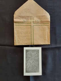 Mont De Lancey
Souvenir - Souvenir of Gethsemane - Jerusalem, Commonwealth Government, WW11 (1939 - 1945)
Olive trees have been a boon to civilization for millennia. The oil extracted from olives can be used for everything from fuel for lanterns to medicinal balms to an essential ingredient in foods. It’s easy to understand why the tree was incorporated into so many early religious practices, but near the Mount of Olives in Jerusalem, a grove of olive trees in Gethsemane provides a direct link to ancient biblical stories. At the foot of the Mount of Olives, a small olive grove would go on to become an important site for Christianity. Gethsemane, taken from the Aramaic word for olive press, is mentioned many times throughout the New Testament as a favorite place for Jesus and his disciples to rest and pray beneath the evergreen olive trees. Today, the Church of All Nations has been constructed in a section of Gethsemane, enshrining the ground where Jesus is said to have last prayed.However, as a privilege, soldiers were given one green envelope per month in which they could send uncensored personal and private letters to loved ones. The soldier had to sign to verify that they had only included private and family matters.A small vintage brown paper WWII AUSTRALIAN Active Service envelope with faded green text explaining its use, which was for letters only. It was Revised July 1942. There is a large green lined open cross on the front with Active Service at the top and (Crown Copyright Reserved). It has an address space on the right. Inside the envelope is a small folded paper souvenir from Gethsemene Jerusalem with a black and white image on the front of a relief sculpture depicting the moment when an angel visits Jesus in the garden of Gethsemane. It is titled 'Gethsemeni'. Inside the small souvenir card is a Daily Prayer for the Dying and, glued to the opposite side, an olive leaf from the Garden of Gethsemane. On the back of the souvenir is a text titled, The Good Work of the Holy Land, which describes the work of the Friars Minor who resided in Jerusalem for seven venturies. Though undated, this document dates from WWII when the soldiers were in the Middle East.'Leaf from the Trees of the Garden of Gethsemane' -
 Wodonga & District Historical Society Inc
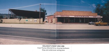
Photograph - Holloways Building Supplies
Eric Holloway began spot milling timber at age of 17. He borrowed fifty pound from an uncle in 1934 to purchase a McCormick Deering tractor and saw bench. He went from farm to farm cutting timber for farmers. For a time, he worked on Shelley Station spot milling with WS Walker and Son. In approximately 1946 Arthur and Eric Holloway established a saw mill at Shelley. Another brother Ernie, a builder and returned soldier, worked with them from time to time. Using timber sawn in the mill he built eight basic houses for the mill workers. The brothers employed many migrants: - Yugoslav, Czechs, Russians, Ukrainians, Serbs as well as other hardworking people. This meant there were families, so Ernie also built and furnished a school at Shelley. Application was made for a teacher from the Education Department. At the Shelley mill the workers used ex-army blitzes, GM trucks (for carting logs) army ducks and a centurion tank for parts. The timber from the mill was trucked to Albury and Wodonga, customers being FA Stowe and Mates Timber. The army was also a big customer with Holloways supplying timber for the army huts that were built at Bandiana. A timber mill that had been built at Tallangatta by State Rivers and Water for the purpose of establishing New Tallangatta, was purchased by Holloway Brothers as an extension of their Shelley operation. In 1954 a new mill was built at Granite Flat on the Omeo Highway and the Shelley operation closed. Ernie Holloway was involved in the building of the mill and accommodation houses in Mitta Mitta. The mill workers travelled from Mitta to work each day. Holloways Building Supplies was established at 49 Tallangatta Rd Wodonga at this time. It was established on four house blocks with a little shed, with more land being acquired as the operation expanded. The brothers realized that it would be more profitable to set up their own timber outlet to supply their customers. Arthur Holloway continued to run the sawmills while Eric Holloway concentrated on the Wodonga business. A hardware store, offices and joinery were built as demand continued for building materials. All the timber arriving in the yard from the mill was hand sorted, providing employment for many. With the milling and timber outlets Holloways provided employment for approximately forty staff. The next generation of the Holloway family became involved. A Hyster forklift was purchased which allowed for bulk handling of the timber. Land was purchased in Sanyo Drive where timber was cleated and dried. Select grade timber, F17 dry framing, builders hardware and tools were sold. Holloways endeavoured to be a one stop shop for framing and fitting out of houses. In 1989 the business was sold to Mt Beauty Timbers who later on sold to Dahlsens. The timber mill was decommissioned. The Holloway family retained the ownership of the premises of 49 Thomas Mitchell Drive leasing to Dahlsens until that operation was moved to Albury in 2013. In 2014 the lease land was sold to two local businesses. Leigh Martin Marine purchased the parcel of land adjoining their business. Lester and Son purchased the remaining block and demolished the premises. A funeral parlour was built on that site.These photos are significant because they document the story of an important Wodonga business.A series of coloured photographs depicting aspects of Holloways Building Supplies business in Wodonga.holloways wodonga, wodonga businesses, timber industry -
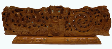 Geoffrey Kaye Museum of Anaesthetic History
Sculpture - Carving, Heke Collier, Mauri Ora, May - July 2016
Professor Alan Merry commissioned the work from New Zealand artist Heke Collier as a gift to the College at his retirement from Council. This artwork was carved by Heke Collier in May-July 2016. It is made from native New Zealand Rimu timber. Heke named this carving Mauri Ora which translates to vitality, well-being or the healing life-force. Tihei Mauri Ora (breath of life) is a well-known Māori saying that was uttered by the first human being. Māori believe that all people and all things have mauri. This carving symbolises the many shapes and forms of mauri with reference to the Māori creation story, and the spiritual and natural worlds. Māori refer to the heavens as Ranginui the sky-father and according to the Māori creation story, Ranginui was pressed against Papatūānuku the earth mother. Their children did not like living in the cramped, dark space between them. One of their sons Tāne separated Ranginui and Papatūānuku to allow light and life into the world. The central male figure carved into Mauri Ora (above) is Tāne. To his right (far right) is his mother Papatūānuku and to his left (far left) is his father Ranginui. Papatūānuku gives birth to all things including human kind and provides the physical and spiritual basis for life. The takarangi (spiral) design in the carving (to the left of Tāne) symbolises the life cycle. Whenua, the word for land also means placenta - organ that nourishes the baby in the womb. Women are associated with the land (whenua) because the land gives birth to people and so do women. In tribal history women have had influence over land and men. Papatūānuku is depicted in the carving to the right of Tāne. Ranginui played a pivotal role in the birth of the sun, moon, planets, stars and constellations – collectively called Te Whānau Mārama (the family of light). Human life and knowledge were said to originate in the realm of Ranginui. Tāne ascended the heavens to retrieve three baskets of knowledge: te kete-tuatea (basket of light), te kete-tuauri (basket of darkness) and te kete-aronui (basket of pursuit). Ranginui is depicted in the carving to the left of Tāne. Tāne had many different roles, and he was given different names to reflect these roles. He is called Tāne-mahuta as god of the forest, Tāne-te-wānanga as the bringer of knowledge, and Tāne-te-waiora as the bringer of life, prosperity, and welfare. His teachings and knowledge are relevant in contemporary times, and the cell-phone carved into his left hand represents this. Tuatara feature in the Māori creation story and some tribes view Tuatara as kaitiaki (guardians) of knowledge. Given that they have lived for more than 220million years. There are birds or manu surrounding Tāne in the carving, who represent Tane’s voice or the voice of the forest. The flax or harakeke depicted in the carving represent the family unit and reinforce the importance of kinship ties. There are plants, ferns, and birds carved into Mauri Ora play an integral role in the life-cycle which represent rongoa Māori or Māori medicine. Traditional Māori carving in Rimu, a native New Zealand wood, with paua insets.merry, alan, anzca council, collier, heke, kaiwhakairo, master carver, rimu -
 Southern Sherbrooke Historical Society Inc.
Photograph - Kirkland family photos
Ethelbert Cyril Kirkland was born in inner Melbourne on 1st November 1900, to Ethelbert George and Mary Ann (nee Cooke). His father died in 1912. On 4th June 1917, while living with his mother in South Yarra and working as a factory hand, Cyril enlisted in the Army. His height was 5' 8" and he gave his age as 18. He was officially enrolled on the 18th June and by October he was in England, specifically in hospital with mumps. After coming clean about his actual age in March 1918, he was discharged on 13th June 1918 and shipped back to Australia, having forfeited all his pay from March onward. On 9th December 1919 he enlisted again, stating he was a single man. He was by then working as a carpenter and had grown 3 inches. He was discharged on 2nd June the following year. He married Mary Ann Reynolds (b. 4th February 1906) on 7th March 1929. For a few years Mary and Cyril moved around, from Moonee Ponds to Iona and then Kelletts Road, Lysterfield. Cyril worked as a farmer and labourer. By 1941 they were running a dairy farm on Engelke Rd. Then they purchased the triangular block of land on (now) Belgrave-Hallam Rd from Mr & Mrs Clarke, where they built a dairy and ran that and a milk delivery service until selling it to Mr Dave Pollock in the 1950s. In 1952 they built the Belgrave South Garage on part of their land at the corner of Belgrave-Hallam Rd and Deviation Rd. Their son Robert (Bobby) ran the garage . Their daughter Mary married Jack Rae from Narre Warren North. Jack played football for Sth Belgrave. Mary died on 27th May 1957 and Cyril died on 6th April 1980. Our society has a long oral history which was recorded with Bobby Kirkland several years ago. -
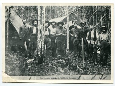 Orbost & District Historical Society
black and white photograph, 1897
This is a surveyors' camp in the McCulloch Ranges April, 1897. Surveyors were among the first European settlers to arrive in Australia. A Surveyor-General was present on the First Fleet, as well as the first two ships which landed in South Australia. These men were issued with instructions to record observations in a journal that included the country’s general appearance, its soil, flora and fauna and the customs and language of local inhabitants. The conditions they worked in were harsh and they embarked on journeys with drays carrying cumbersome surveying and camping equipment, spending months camping out in the bush and mapping the land. It was not until well into the second half of the nineteenth century that the professional training of surveyors became mandatory in Australia. This is a pictorial record of a surveyors' camp in the late 19th century.A black / white photograph of a group of men standing at a campsite in the bush. Two tents are in the background.on the front - "Surveyors Camp, McCulloch Ranges" Some names have been added for identification - Bates, Thorn and others which cannot be read.surveyors-camp-mcculloch-ranges land-settlement -
 Supreme Court of Victoria Library
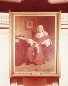
Portrait, George Higinbotham
The portrait was commissioned after Higinbotham's death in 1893. A committee was appointed to investigate the making of a portrait and they appointed Mr L Bernard Hall, instructor and later director of the National Gallery of Victoria. George Higinbotham (1826-1892) had a distinguished career as a newspaper editor and politican before becoming a Judge of the Supreme Court in 1880 and the third Chief Justice in 1886. Higinbotham was a long serving attorney-general in the 1860s colonial administration. Higinbotham was active in the education, land and constitutional debates of his time. He played a prominent role through his chairmanship of the of the Royal Commission into Public Instruction with regard to the introduction of the free and secular primary school education.The portrait of George Higinbotham is of historic significance as the depiction of an important public figure in 19th Century Victoria. The painting is also of interest as an early example of L Bernard Hall's Australian works. Portrait in Oils of George Higinbotham. Higinbotham is seated at his desk, pen in hand. He is dressed in his judicial robes, ready for Court.Signed Lower right B Hall 95. Plaque on frame : The Hon. George Higinbotham Judge of the Supreme Court 1880-1886 Chief Justice of the Supreme Court 1866-1892supreme court, higinbotham george, hall bernard