Showing 11018 items matching " land"
-
 Warrnambool and District Historical Society Inc.
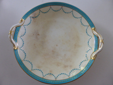
Plate, Rolfe dinner plates x 4, 1864
These dishes were part of a crockery set used in the George Rolfe household at Lyndoch, Warrnambool. George Rolfe (1836-1919) was a Melbourne tea merchant who acquired land at the mouth of the Hopkins River in Warrnambool from the 1880s on as a holiday home. He developed the property over the years, adding a windmill and reservoir, bone and chaff sheds, a stable, jetty and boathouse and an extensive garden. In 1891 he married Mrs Annie Lake and it was his stepdaughter, Florence Lake who built the house, Lyndoch in the 1920s. This building today forms part of an Aged Care Facility. This item is part of the larger Rolfe dinner set as described on Victorian Collections at VC001421 and VC001422These dishes are of importance as they belonged to the George Rolfe family of Lyndoch, Warrnambool. They demonstrate the quality of the household goods used by more affluent families in the second half of the 19th century. These are four china serving dishes or plates which are part of a set of crockery used in the Rolfe Lyndoch household in Warrnambool. The dishes have a circular base with a circular dish resting on the base. The dishes have or had two handles with these handles and the edges of the dishes being gold trimmed. Around the rim of the dishes is a pattern of loops and dots etc of teal and gold. One dish (.1) has no handles, one dish (.4) has one handle only and two dishes are cracked (.3 & .4) . Two dishes are stained, one severely (.2 & .4) ‘Minton’ george rolfe, florence lake -
 Warrnambool and District Historical Society Inc.
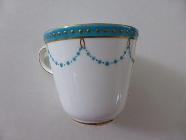
China, Cups x 4, 1864
These dishes were part of a crockery set used in the George Rolfe household at Lyndoch, Warrnambool. George Rolfe (1836-1919) was a Melbourne tea merchant who acquired land at the mouth of the Hopkins River in Warrnambool from the 1880s on as a holiday home. He developed the property over the years, adding a windmill and reservoir, bone and chaff sheds, a stable, jetty and boathouse and an extensive garden. In 1891 he married Mrs Annie Lake and it was his stepdaughter, Florence Lake who built the house, Lyndoch in the 1920s. This building today forms part of an Aged Care Facility. This item is part of the larger Rolfe dinner set as described on Victorian Collections at VC001421 and VC001422These cups are part of a crockery set, and are kept because they belonged to George Rolfe, a prominent property owner and farmer in Warrnambool in the late 19th century and early 20th century. The items, dating from 1864, have social significance showing the type of crockery used by a more affluent family in the 19th century.Four small white cups decorated with aqua band around the top of each cup . A scalloped pattern of dots are suspended from the solid band which is decorated with a row of gold dots. There is a gold rim at the base of the cup.Mintonrolfe, lyndoch, warrnambool, minton cups, mrs annie lake -
 Warrnambool and District Historical Society Inc.
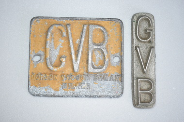
Milking Machine Plates (2), 1950s
These items come from a Gordon Vacuum Break Milking Machine. Vacuum Break milking machines were popular from the 1930s on, with the systems interrupting or breaking the constant milking vacuum, thus avoiding or reducing the harmful effects of vacuum acting constantly on the cow’s teats. An inserted rubber section acted as a valve which affected the pinching action by closing and opening alternately. These items came from a milking machine which was used on the property of Reginald Dalton Hooker and his wife Marjorie. The property was at 155 Rooneys Road, Dennington and twenty cows were milked on land irrigated by a bore. The milk was supplied to the Nestles Factory in Dennington (now Fonterra). These two plates are of interest as they are reminders of the local dairying industry during the mid 20th century. Dairying remains today the chief industry of the Warrnambool district..1 This is a rectangular metal plate with two holes at each end for attachment to a machine and with raised metal lettering on the inside surface. The plate has been painted light brown but the paint is now peeling. .2 This is a small rectangular silver-coloured plate with raised lettering on the front. .1 GVB Gordon Vacuum Break Milker .2 GVBreginald hooker, dennington, gordon vacuum break milkers, history of warrnambool -
 Glen Eira Historical Society
Newsletter - Royston, Kooyong Road, 240, Caulfield
Caulfield Community Care Centre, volunteers newsletter dated 1/1994. With written article by Kelvin Hughes on recollections of Royston. A handwritten compliments slip to the secretary of Caulfield Historical Society, from Caulfield Citizens’ Advice Bureau, and Caulfield Community Care Centre. A two page photo copy of recollections of Royston, written by Kelvin Hughes, and from the Community Cares Centre Jan/1994 from the newsletter. Also includes a handwritten and drawn plain of the ground & upper floor from the Caulfield Citizens Advice Bureau concerning the Newsletter. Also included is an unsigned undated ref to Royston as the home of James Mirams, until 1888 and to Land Boom and Bustly Michael Cannon.royston, slatter enid, hughes kelvin, kooyong road, caulfield general, calvin barbara, caulfield community, medical centre, mirams james, care centre, caulfield citizens, caulfield, slatter daisy, advice bureau, cannon. michael -
![Photograph - Digital image, Bosch family [as adults], 1914c](/media/collectors/4f729f5697f83e03086015b8/items/5441bd572162f10c081ec065/item-media/5441bd9b2162f10c081ec218/item-fit-380x285.jpg) Greensborough Historical Society
Greensborough Historical SocietyPhotograph - Digital image, Bosch family [as adults], 1914c
Photograph of Bosch (Bush) family as adults. Left to right: John Adam Bush Senior (Johannes Adem Bosch born 19/8/1867 died1925), Frederick William Bush (31/3/1892-20/8/1952), John Adam Bush Junior (3/2/1895-24/6/1970), Amelia Suzanne Bush (b25/6/1893). Johannes Bosch came to Australia in 1884 aged 17. He married Henrietta Duck, had 3 children and divorced in 1903. Around 1902 he anglicized the family name to Bush.They farmed along the Plenty River having purchased land from Flintoff. Digital copy of black and white studio photograph.john adam bush, johannes adem bosch, frederick william bush, amelia suzanne bush, bosch family, bush family -
![Photograph - Digital image, Willis Vale [side view], 1950c](/media/collectors/4f729f5697f83e03086015b8/items/5502a2592162f11024c32328/item-media/5502a2852162f11024c3268d/item-fit-380x285.jpg) Greensborough Historical Society
Greensborough Historical SocietyPhotograph - Digital image, Willis Vale [side view], 1950c
Willis Vale: House built by Edward Maygar, Robert Whatmough lived there mid 19th century and later sold to Partington family. It was located on the Plenty River at Partington's Flat Greensborough. Land use included farming and orchards. The derelict Willis Vale house was vandalized in 1964 and destroyed when a fire originating from North Plenty Gorge - Kurrak Road - was lit by two teenage boys and made its way several kilometres down to Partington's Flat Greensborough. This photo was taken after the Partington's moved house in 1947. across the river where Alan built their new Alwyn house that had access to electricity. Home of the Partington family Home of the Partington familyDigital copy of black and white photograph.willis vale, partington, whatmough, maygar -
 Eltham District Historical Society Inc
Negative - Photograph, George W. Bell, Shillinglaw Cottage, Main Road, Eltham, c.1964
Shillinglaw Cottage on its original site (present day 895 Main Road) showing old picket fence c.1964. The cottage and land were purchased by the Shire of Eltham as the site for a new shire office building. The cottage was destined for demolition but members of the community concerned at losing one of the areas earlist buildings (built c.1859) initiated a fund-raising campaign to save the cottage. In 1964 the cottage was dis-assembled, all the bricks numbered and reassembled several hundred meters to the south on a site between the Gahan house and the Eltham Railway Trestle Bridge (present-day Panther Place), which bcame known as the Eltham Common.This photo forms part of a collection of photographs gathered by the Shire of Eltham for their centenary project book,"Pioneers and Painters: 100 years of the Shire of Eltham" by Alan Marshall (1971). The collection of over 500 images is held in partnership between Eltham District Historical Society and Yarra Plenty Regional Library (Eltham Library) and is now formally known as the 'The Shire of Eltham Pioneers Photograph Collection.' It is significant in being the first community sourced collection representing the places and people of the Shire's first one hundred years.Digital image 4 x 5 inch B&W Negsepp, shire of eltham pioneers photograph collection, eltham, shillinglaw cottage, fences, george w. bell collection, houses, main road -
 Eltham District Historical Society Inc
Photograph, George W. Bell, Our Lady Help of Christians Catholic Church, Henry Street, Eltham, c.1962
The second St Mary's Catholic Church Eltham was located at the corner of Main Road and Henry Street, Eltham and was opened/blessed October 13, 1912. The wooden church was built to replace an earlier brick church also known as St Mary's (1865-1912), which had been situated on the main road near present day Wingrove Park. The church and land cost £1,400 (Evelyn Observer). The wooden church was destroyed by fire in 1961. This modern (1960s) style church was built to replace the destoyed St Mary's and was called Our Lady of Help Christians. By this time Henry street had been closed off from Main Road.This photo forms part of a collection of photographs gathered by the Shire of Eltham for their centenary project book,"Pioneers and Painters: 100 years of the Shire of Eltham" by Alan Marshall (1971). The collection of over 500 images is held in partnership between Eltham District Historical Society and Yarra Plenty Regional Library (Eltham Library) and is now formally known as the 'The Shire of Eltham Pioneers Photograph Collection.' It is significant in being the first community sourced collection representing the places and people of the Shire's first one hundred years.Digital image 4 x 5 inch B&W Neg B&W printsepp, shire of eltham pioneers photograph collection, eltham, roman catholic church, churches catholic, main road, george w bell collection, our lady of help christians church -
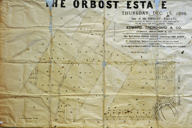 Orbost & District Historical Society
poster, 1898
This poster was made for the sale of the 1,440 acres of Orbost Station after the death of Sir William Clarke. It was sold by Edward Trenchard & Co. which was the oldest Stock and Station agent in Victoria assisted by Desailly, Macarthur & Co were livestock experts. Sir William Clarke had taken over the Orbost run from the McLeods in 1870. When Sir William died the property was owned by his son, Rupert who offered the land for sale at 4 pounds per acre. No sale resulted and the property was leased for a few years until in 1898 it was subdivided and sold to many of Orbost's first families. (info. from In Times Gone By- Deborah Hall)This is an important reminder of the very early history of the settlement of Orbost.A rectangular paper poster for the sale of the Orbost Estate on Forest Road, Orbost. It is dated "Thursday Dec 1898" and was made for the sale of the 1,440 acres of Orbost Station after the death of Sir William Clarke. The poster gives written details of the sale and a plan of the property.orbost-station clarke-sir-william orbost-estate -
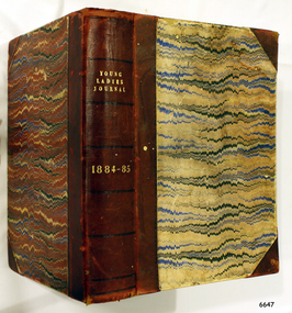 Flagstaff Hill Maritime Museum and Village
Journal - Women's Journal, Curtis Publication Company, Young Ladies Journal 1884 - 1885, ca. 1884
This is one of two books donated together and believed to have belonged to the Purvis family. The books were rescued from recycling. It has the name of C A. Purvis on the front endpaper. The other book from the same donor has the inscription "C. Purvis". The inscription on the back endpaper of this book is of interest, 'Edith Fox, Gheringhap, 1879' as it is earlier than the earliest journal in the book. Perhaps it is the birth date of Edith. It is also interesting that an notice was printed in the Geelong Advertiser in 1922 stating that Edith Susan Fox of Box Hill had an interest in land in Gheringhap. Gheringhap is a town on the Midland Highway, Victoria, 15 km northwest of Geelong, and 6.7 km southeast of Bannockburn. This is one of two journals of ladies fashion, fancy work and stories that reflect the interests of women the late 1800s. They are a useful source of historical information and include advertising and thought provoking articles .Young Ladies Journal 1884 - 1885; a collection of journals in a burgundy leather-bound spine and hardcovers with a black, blue, burgundy and cram pattern. The Journal contains illustrations and articles of a wide variety including fashion, fancy work and family reading. Inscriptions are on the spine and the front and back end pages. Inserted between pages is a loose Christmas Magazine from The Sun, dated 24th Dec 1954. Published by the Curtis Publication Company, Philadelphia, Pennsylvania, Inside the front cover on the first page, handwritten in pen; "C.A. Purvis 1955" Inscription, script in black ink; "Edith Fox / Gheringhap / 1879"flagstaff hill, flagstaff hill maritime museum and village, warrnambool, maritime museum, maritime village, great ocean road, shipwreck coast, young ladies journal 1884 - 1885, young ladies journal, 1884-1885, ladies journal, women's journal, fashion, fancy work, family reading, illustrated magazine, purvis, c a purvis, edith fox, gheringhap, 1879, edith fox gheringhap 1879 -
 St Kilda Historical Society
Photograph, Donald McDonald, Yanakie St Kilda, 1872
Built for William Wilmot Couche (1829-1890) probably in 1869. The architect was Lloyd Tayler (1830-1900) and it was designed in the polychromatic Lombardic style that had been introduced to Melbourne by the architect Joseph Reed (1822-1890). Couch was a prominent merchant and businessman. He founded the firm Couch Calder & Co, was director of several insurance companies and a member of the Melbourne Harbour Trust for many years. From about 1900 the house was renamed Wavenhoe. In the 1920s Wavenoe Avenue was constructed through its gardens and most of the land sold off including the blocks at the corner of Hotham Street and Alma Road. The house still stands opposite St Kilda cemetery.black and white photograph copy -
 8th/13th Victorian Mounted Rifles Regimental Collection
Photograph
This exercise was conducted by A Squadron 8/13 Victorian Mounted Rifles using Land rovers and trucks. The 8th/13th Victorian Mounted Rifles was raised as a regiment of the Royal Australian Armoured Corps on 1 May 1948 with Headquarters in Melbourne and squadrons in Sale, Benalla/Wangaratta and Albury. In 1955 Regimental Headquarters moved to Wangaratta and a second squadron was located at Albury. The Sale squadron transferred to 4th/19th Prince of Wales’s Light Horse. In 1977 8/13 VMR Regiment was reduced to an independent squadron A Squadron 8th/13th Victorian Mounted Rifles and in 1991 was linked with 4th/19th Prince of Wales’s Light Horse forming the VMR Squadron of that regiment.Colour photograph of convoy of vehicles entering Warrnambool Victoria during 8/13 Victorian Mounted Rifles annual exercise, 1985 -
 Bendigo Historical Society Inc.
Document - Marong racecourse
Copied from a copy of an original photo loaned to me by Mrs. Jean Grimson. The photo shows patrons arriving at a race meeting being held at the racecourse fronting the Loddon Valley Highway opposite where Mrs. Grimson was living in 1985. The photo was thought to be taken around 1920? The Swan Hill train used to slow down for race patrons to jump off and enter the course from the "rear". The course was later transferred to land fronting the Myers Flat - Marong Road & Williams Road and with a railway siding on the Bendigo side of the railway crossing Myers flat (behind the Allies Hotel). Fron Q. C. Binks 29/01/2001.historic referenceHistoric photo circa 1920.race goers entering marong racecourse circa 1920, races -
Bendigo Historical Society Inc.
Document - Forests Commission of Victoria Northern Area Fire Protection Policy, Statement, Future Bush Fire Policy, Plan for Fire Control, 1938-1939
Fanned by powerful winds, the Black Friday fires (13 January 1939) swept rapidly across large areas of Victoria, causing widespread destruction. Flames leaped large distances, and giant trees were blown out of the ground by fierce winds. Large pieces of burning bark (embers) were carried for kilometres, starting new fires in places that had not previously been affected by flames. Almost two million hectares burned across the state. Large areas of state forest, containing giant stands of Mountain Ash and other valuable timbers, were destroyed. As a result, approximately 575,000 hectares of reserved forest and 780,000 hectares of Crown land burned.Four Files Forests Commission of Victoria Northern Area Report on the 1938-39 Fire Season; and the Fire Protection Policy in Respect of Field activities Prior to the Incidence of the 1939 Fires. history, bendigo, forests commision of victoria, 1939 bush fires -
Bendigo Historical Society Inc.
Audio - Making Tracks, c1980s
Bendigo Workshops is a railway workshop in Bendigo, Victoria, Australia. It is located in the north of the city beside the junction of the Swan Hill and Deniliquin railway lines. The site covers 10.3 hectares of land and has 31 separate buildings, including a 10,000 sqm main workshop building and six kms of railway track. The workshops were opened in November 1917 by the Victorian Railways. It opened in response to political pressures from provincial groups for decentralization, with the Victorian Railways preferring the cheaper option of expanding the existing Newport Workshops in suburban Melbourne. The 1980s were a time of restructuring, and on the breakup of the Victorian Railways the workshops passed to the State Transport Authority and then the Public Transport Corporation.Three Audio Files - by David Bennet, Davis Moon and Kevin Whelan who worked at the Bendigo Railway Workshops. The three share their working life memories history, bendigo, bendigo railway workshops -
 Kew Historical Society Inc
Photograph, Kew RSL, Cotham Road, circa 1965, c. 1965
The Kew RSL is located in "Wilton" House, 63 Cotham Road. The RSL was established on January 1st 1920, later joining with the Hawthorn RSL. In November 1931, Cr. C.R. Parry organised the reformation of the Kew Sub Branch and its first president was Brig-Gen Pat McGlin, a veteran of the Boer War and the First World War. On July 17th 1932, the club rooms first opened on Army land at the corner of High Street and Highbury Grove. In late November 1948, the Kew RSL bought the "Wilton" house from the Kew City Council for £10,067, opening seven years later in July 1955. [Source: Victorian Heritage Database]This work forms part of the collection assembled by the historian Dorothy Rogers, that was donated to the Kew Historical Society by her son John Rogers in 2015. The manuscripts, photographs, maps, and documents were sourced by her from both family and local collections or produced as references for her print publications. Many were directly used by Rogers in writing ‘Lovely Old Homes of Kew’ (1961) and 'A History of Kew' (1973), or the numerous articles on local history that she produced for suburban newspapers. Most of the photographs in the collection include detailed annotations in her hand. The Rogers Collection provides a comprehensive insight into the working habits of a historian in the 1960s and 1970s. Together it forms the largest privately-donated collection within the archives of the Kew Historical Society.The exterior of the Kew RSL on the corner of Cotham Road and Charles Street, Kew. Designed by Guyon Purchase for Dr. William Walsh in 1886, the building was originally called Wilton."Chap 59. Cotham Rd. Built/Commences about 1885-6. Present day Wilton . Kew RSSUILA rooms. (Rumour of sale 1972?)"wilton, dr william walsh, guyon purchas, dorothy rogers, cotham road (kew) -
 Port Fairy Historical Society Museum and Archives
Photograph
In 1844 a carpenter called David McLaws secured the lease on the land on the south west corner of James and Bank Streets. He later converted this to freehold by which time he had erected the Caledonian Inn. This building has been continually licensed since that time , and is believed to be the longest continual license held in Victoria. The dormer windows in the part of the building facing James street hide the fact that there is only a skeleton of rooms that were meant to be built there. They were unfinished because the labourers left town when gold was discovered at Ballarat in 1853. An advertisement for the time says “There were four parlours, a bagatelle room, eight bedrooms, a detached kitchen, stable and kitchen garden”. Well known hotel Thought to be the oldest continuously licenced hotel in VictoriaBlack and white photograph of 2 story building with dormer windows on corner hotel, building, james street, bank street, david mclaws -
 Port Fairy Historical Society Museum and Archives
Photograph
In 1844 a carpenter called David McLaws secured the lease on the land on the south west corner of James and Bank Streets. He later converted this to freehold by which time he had erected the Caledonian Inn. This building has been continually licensed since that time , and is believed to be the longest continual license held in Victoria. The dormer windows in the part of the building facing James street hide the fact that there is only a skeleton of rooms that were meant to be built there. They were unfinished because the labourers left town when gold was discovered at Ballarat in 1853. An advertisement for the time says “There were four parlours, a bagatelle room, eight bedrooms, a detached kitchen, stable and kitchen garden”. Well known Hotel thought to be the longest continuous licenced hotel in VictoriaBlack and white photographhotel, bank street, port fairy, james street, building -
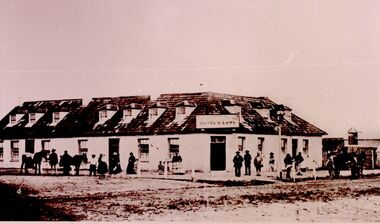
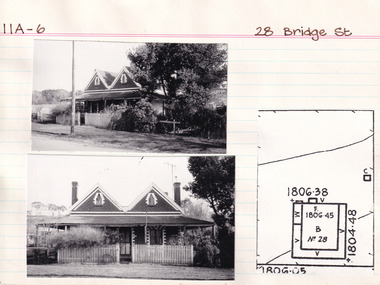 The Beechworth Burke Museum Research Collection
Card (Series) - Index Card, George Tibbits, 28 Bridge Street, Beechworth, 1976
George Tibbits, University of Melbourne. Faculty of Architecture, Building and Town & Regional PlanningIndex system that support the research for Beechworth : historical reconstruction / [by] George Tibbits ... [et al]Arranged by street names of BeechworthEach index card includes: street name and number of property, image of property, allotment and section number, property owners and dates of ownership, description of the property according to rate records, property floor plan with dimensions.beechworth, george tibbitsbeechworth, george tibbits -
 Melton City Libraries
Photograph, Brooklyn Estate, Unknown
Brooklyn Park homestead built 1875 by Stephen George Staughton, son of Simon Staughton. In 1907 the residence was refurbished for Cr Stephen John Staughton who was returning from England with his bride. The building contained over 25 rooms some 25x20 feet. There were elaborately decorated rooms with friezes, embossed wall papers, massive curtains, marble and carved mantle pieces. A Ryder Erickson Hot air engine pumped water from underground tanks up to elevated tanks to circulate water through the house. Acetylene gas generator for 100 light and chandeliers. Prominent family with civic connection in Melton holding very large areas of land. 'Brooklyn' mansion built by Stephen Staughton, local identities, pioneer families -
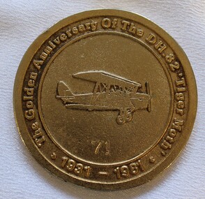 Wodonga & District Historical Society Inc
Medal - Antique Aeroplane Association Wodonga Air Show Medallion, 1981
This medallion was produced to commemorate the Antique Aeroplane Association of Australia's annual air show which was held at Wodonga in 1981. It took place at Joe Drage's Air World Museum in Wodonga, Victoria. It recognised the 50th anniversary of the manufacture of the first De Haviland 82 Tiger Moth in 1931. This medallion and 2 other linked medallions were owned by Mr. Clive Cossor. He spent a lot of time at Drage's Historical Aircraft Museum and also helped transport gliders. He was also at the Albury racecourse as a teenager to assist in moving the Uiver when it was forced to land in a storm during the MacRobertson Trophy Air Race from London to Melbourne in October 1934.This medallion is significant as it records an important event recognising aviation in Australia and recognises the development of the Tiger Moth aircraft.A medallion produced to commemorate the Antique Aeroplane Association of Australia's annual air show held at Wodonga in 1981On the front around the medallion surrounding an image of a Tiger Moth aircraft: "The Golden Anniversary of the DH. 82 "Tiger Moth" 1931-1981" Numbered 71 On reverse around the edge: "Antique Aeroplane Association of Australia/ WODONGA 1981". In the centre: "SPONSORS/2AY/ALBURY-WODONGA"aviation history, antique aeroplane association of australia, joe drage airworld, airshow wodonga, dh tiger moth -
 Sunbury Family History and Heritage Society Inc.
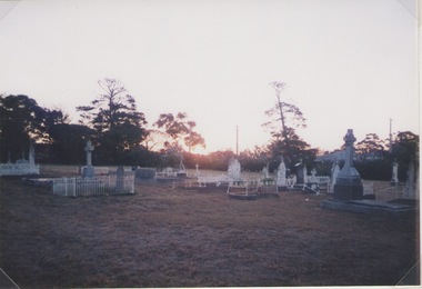
Photograph, Lydia Keyworth, Sunbury Cemetery, March 2001
The photograph of Sunbury Cemetery at sunset was entered into the Photograph Competition organised by the former Sunbury & District Heritage Association in March 2001.In 1862, land set aside in Cemetery Road for the Sunbury Cemetery was laid out in the following Christian denominational groups, Church of England, Roman Catholic, Baptist, Methodist, Presbyterian and Lutheran. Other non-denominational sites were set aside for paupers, heathens, Asians and pagans. Rebecca Jenkinson was the first person to be buried there in 1862. Over the years the size of the cemetery has expanded but it still occupies the original site off Shields Street in Sunbury and the names of the denominational divisions have changed over the years reflect a more inclusive outlook.Sunbury Cemetery replaced other smaller graveyards that were situated in some of the local church grounds and the earlier cemetery that was at The Gap township.A non-digital coloured photograph of a cemetery landscape with a number of old graves scattered across the open space. Some have small fences around them, while others simply display the headstones. There are trees in the background. sunbury cemetery, shields street, cemetery road, sunbury, cemeteries -
 Linton and District Historical Society Inc
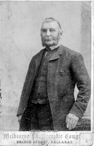
Photograph, Melbourne Photographic Company, Bridge St, Ballarat, Mr W.G Bennett, butcher
William Garnsworthy Bennett was at Linton's Diggings in 1856, when he married Susan Williams. Both had migrated from England. W. G. Bennett established a butcher's shop in Linton Township, and later purchased farming land and other town allotments. William and Susan Bennett had twelve children, eight of whom survived to adulthood. W. G. Bennett was a Trustee of the Linton Town Common, was elected to the Grenville Shire Council in 1871,and founded the Linton Rifle Club. After W. G. Bennett's death in 1903, the butcher's shop was run by the Todd family. William and Susan's daughter Elizabeth (Lizzie) married William Todd in 1882.Sepia photograph of a gentleman with long sideboards, moustache and beard, wearing a suit."Mr W G Bennett, Butcher"william garnsworthy bennett, w. g. bennett [butcher] -
 Melbourne Tram Museum
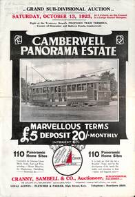
Ephemera - Real estate sale, Cranny Sambell & Co, "Camberwell Panorama Estate", Oct. 1923
Pamphlet advertising the sale of land at the "Camberwell Panorama Estate" - Doncaster and Bulleen Road 13-10-1923. Gives terms of sale, photos showing the views and a nearby shopping centre. Has a large photo of MMTB No. 20 on the front cover. The tramcar is of the Hawthorn Tramways Trust four-door bogie type. MMTB No 20 was an ex-Prahran and Malvern single trucker or small tram A class. Gives details of the 110 lots to be sold, terms, location, and that the tram was proposed to be extended to the corner. This extension took place in 1937. The locality plan shows proposed plans for tram lines in Belmore Road and Burke Road north of Whitehorse Road. Demonstrates the style of land sale pamphlet including the availability of tram services to prospective purchasers.Pamphlet - folded - printed in two colours of cream coloured paper with photographs and plans.has pencil notes on the top of the front page.sale of land, trams, real estate, camberwell panorama estate, east camberwell, doncaster road, bulleen road, tram 20 -
 Warrnambool and District Historical Society Inc.
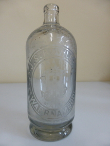
Bottle, J. S Rowley
The making of cordials and aerated waters was an important industry in Warrnambool from the time of the first settlement up to the 1980s. John Rowley was a prominent producer of aerated waters and cordials from 1868 to his death in 1893 (the Warrnambool Steam Aerated Works). He was known for his originality in the production of soft drinks and produced 20 varieties of drinks, including his own Henneberry Wine and Lime Fruit Champagne, both non-alcoholic. In the 1870s he was producing 600 dozen bottles a day and in the 1880s his cordial factory occupied half an acre of land and employed 13 people. He won many awards for his products at local Agricultural Shows. Warrnambool cordial bottles are of considerable significance as examples of an important industry now gone. Rowley is a significant person in the history of 19th century Warrnambool industries and Rowley bottles are of considerable importance, especially this one, made for efferverscent drinks. This is a heavy glass bottle (no stopper) possibly used for hop bitters or ginger wine or some contents that had high efferverscent qualities. The bottle has a heavy indented base. Oval etching ‘J.S.,Rowley Warrnambool’ with ‘Trade Mark’ and monogram. ‘J.R.’ in the centre of the oval. ‘Made in France’ is at the bottom edge of the oval inscriptions.warrnambool, john rowley warrnambool, rowley softdrinks, warrnambool steam aerated works, rowley bottle -
 Eltham District Historical Society Inc
Photograph - Digital Photograph, Marguerite Marshall, Eltham Lower Park, 20 April 2008
Originally a race course, the park has brought the community together with a variety of activities. Published: Nillumbik Now and Then / Marguerite Marshall 2008; photographs Alan King with Marguerite Marshall.; p45 Once used for horse racing, which attracted visitors from Melbourne, the Eltham Lower Park has brought the community together with a wide range of activities. Horse riding is now enjoyed as a recreation in the park as are other sports. The park also includes the Diamond Valley Railway miniature trains and a sanctuary for the rare and vulnerable Eltham Copper Butterfly. Eltham Lower Park, with other parks, forms an almost continuous green band from Eltham’s centre, along the Diamond Creek to the Yarra River.1 Before European settlement the Wurundjeri people met on this land, particularly at the junction of the Diamond Creek with the Yarra River, which they called Birr-arung. This is commemorated by the sculpture, Not just a Pretty Place by Aleks Danko, winner of the 2000 Nillumbik Art in Public Places Award. The first European to settle here was probably Henry Foley, who in 1841 used it as part of his pastoral run. Foley sold his leasehold to Joseph Wilson in 1845, who soon after sold it to Frederick Falkiner. During the 1840s the future park was part of a government square mile (2.6 sqkm) reserve, north of the Yarra, within the Parish of Nillumbik, later named Eltham. Soon the land was used for horse racing after nearby residents cleared ten acres (4ha) in the early 1850s. A three-quarter of a mile (1.2km) race secured the winner the £10 Publican’s Prize. In response to popular demand, the newly formed Eltham District Road Board petitioned the Surveyor General of the Colony of Victoria, in 1856, for 36 acres (14.6ha) of crown land for a racecourse and recreation. By 1858 the Eltham races had become an institution. ‘Many skirmishes occurred and the way home was paved with temptation, with sly-grog for sale.3 In the early 1870s, two jockeys were sons of the police officer in charge of the Eltham Police Station, Miles S Lyons. Another ten acres (4ha) was added to the area in 1866 and 12 acres (4.8ha) – Hohnes Hill – in 1870. In 1866, two acres (0.8ha) on the creek banks became an animal pound with William Walsh the pound keeper in 1870, but this was later incorporated into the park. By 1877 the area was called a public park but horse racing and training continued into the 1920s. In the mid-1900s trotters were trained on a circuit road. In 1953 the Eltham Pony Club was established and used a cross-country course on Hohnes Hill. From the mid 1950s the club held the Eltham Easter Fair at the park, later to include a procession along Main Road from the town centre to the park. The park also attracted picnic parties and campers from the inner suburbs as did Wingrove Park, and businesses catering for visitors, sprang up on the opposite side of Main Road. Bus-loads of school children visited the park for Gould League bird days in the 1960s. In 1979 the Eltham Shire Council bought Lenister Farm, linking the park with the Yarra River. The Lenister Farm wetland includes a bird hide, viewing platform and interpretive signs.5 Pioneer Henry Stooke, later Road Board chairman, bought the 11 acres (4.5ha) - later to become Lenister Farm - from the Crown in 1862. Stooke never lived on this site and the two houses at Lenister Farm were built in the 20th century. Since its formation in 1871, the Council has controlled this crown land, which it named Eltham Park. But in the 1920s Eltham Council bought land near the town centre for a park, which it named Eltham Central Park. To avoid confusion the Council renamed Eltham Park, Eltham Lower Park. Since 2004 the Yarra footbridge has linked the park with the Yarra Valley Metropolitan Park and the Main Yarra Trail.This collection of almost 130 photos about places and people within the Shire of Nillumbik, an urban and rural municipality in Melbourne's north, contributes to an understanding of the history of the Shire. Published in 2008 immediately prior to the Black Saturday bushfires of February 7, 2009, it documents sites that were impacted, and in some cases destroyed by the fires. It includes photographs taken especially for the publication, creating a unique time capsule representing the Shire in the early 21st century. It remains the most recent comprehenesive publication devoted to the Shire's history connecting local residents to the past. nillumbik now and then (marshall-king) collection, eltham lower park, eltham park -
 Eltham District Historical Society Inc
Photograph - Digital Photograph, Alan King, Kinglake National Park, 27 March 2008
Fern gullies around Jehosaphat Gully Covered under National Estate. Published: Nillumbik Now and Then / Marguerite Marshall 2008; photographs Alan King with Marguerite Marshall.; p125 The magnificent Kinglake National Park, fringing Nillumbik’s north, is the largest national park close to Melbourne. Thanks to the vision and hard work of a band of local people, the park was created from what was rapidly becoming degraded land. Seeing a threat to Kinglake’s indigenous flora and fauna, several prominent local people campaigned for a national park, which was established in 1928.1 Since then, the park has grown through donations and acquisitions of land, from around 13,800 acres of land (5585ha) to 22,360 hectares. The Sugarloaf and Everard Blocks – of almost 8000 hectares – stand in Nillumbik and the park extends into Mitchell and Murrundindi Shires and the City of Whittlesea. Mt Everard commemorates William Hugh Everard, State member for Evelyn when the park was established. Before 1928, European settlers had degraded the Kinglake area, which was named after the celebrated English author and lawyer, Alexander William Kinglake. Remains of gold shafts and diggings in the park are reminders of Kinglake’s first settlers, who hoped to strike it rich at the gold diggings. But like other gold fields in this shire, they proved not very lucrative and soon timber cutting replaced mining in importance. However, before long, the accessible timber supply ran out, so in the 1920s agriculture took over – particularly potatoes and berry fruits – which involved large-scale clearing.2 The park’s instigator was retired Melbourne University Professor of Music, William Laver.3 As chair of the Kinglake Progress Association he began negotiations to have crown lands on the southern scarp of the Great Dividing Range reserved as a national park. Even before the park was proclaimed, from 1927, KPA members cut tracks to the major scenic points. Professor Laver was one of several people who gave land for the park, donating around 50 acres (20ha), including the Jehosaphat Gully.4 Laver chaired the park’s first Committee of Management, which raised money to employ a ranger and provide facilities, including tracks and roads for fire protection vehicles, toilets and shelters. The committee charged fees for firewood collection, some grazing of livestock, and visitor entrance, and obtained small State Government and Eltham Shire grants. In 1957 the State Government provided revenue for national parks. Then, in 1975, the State Government took over the management and the Committee of Management became an advisory committee, which disbanded in 1978. Originally, the park covered crown land in the Shires of Eltham and Whittlesea; then Wombelano Falls in Yea and other areas were added. In 1970 the park extended into the Shires of Eltham, Healesville, Whittlesea and Yea.5 Bush fires have been an ongoing problem. In 1939 hundreds of eucalypts and acacias had to be sown around the Jehosaphat Gully to rejuvenate the forest. To manage bushfires, the Committee of Management, then the State Government, worked closely with the Forestry Commission, shire councils and local fire brigades. Early national parks focussed on recreation. But by the 1980s, conservation, education and scientific research became more important, playing a vital role in preserving representative samples of the natural environment. Each year many thousands of people use the park’s extensive network of walking tracks amongst the protected plant and animal life as well as camping, cycling and horse riding. The park, along the slopes of the Great Dividing Range, has lookouts revealing magnificent views of the Melbourne skyline, Port Phillip Bay, the Yarra Valley and the You Yangs. Vegetation in the Masons Falls area includes messmate forest, Austral grass-trees, ferns and Hazel Pomaderris. In spring, orchids, lilies, everlasting daisies, correas, grevillea and heath appear. Around Jehosaphat Gully are wet and dry forest, fern gullies and banksia. Animal life includes wallabies, kangaroos, koalas, echidnas, possums, gliders and bandicoots. Male lyrebirds can be heard mimicking in the Jehosaphat Gully, particularly in the Everard Block in winter.This collection of almost 130 photos about places and people within the Shire of Nillumbik, an urban and rural municipality in Melbourne's north, contributes to an understanding of the history of the Shire. Published in 2008 immediately prior to the Black Saturday bushfires of February 7, 2009, it documents sites that were impacted, and in some cases destroyed by the fires. It includes photographs taken especially for the publication, creating a unique time capsule representing the Shire in the early 21st century. It remains the most recent comprehenesive publication devoted to the Shire's history connecting local residents to the past. nillumbik now and then (marshall-king) collection, kinglake national park, jehosaphat gully -
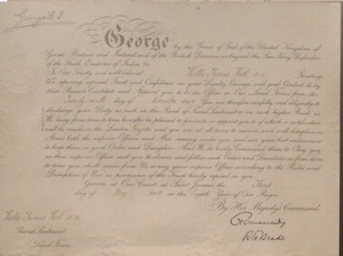 Red Cliffs Military Museum
Certificate, Rank Promotion, 3/5/1918 (exact)
This is another of the documents held within a frame 90.5cm X 66.5cm, covered by no-reflective glass of the Walter Thomas West Collection.Official Royal Document Certificate possibly done by caligrapher in old English script,signed by King George V, and a signature which is not decipherable.Top Left hand Corner: George R.I. (Signature of King George V). Main Face of Certificate: 13 George, by the Grace of God of the united Kingdom of Great Britain and Ireland and of the British Dominions beyond the seas. King Defender of the Faith Emporer of India etc. To our Trusty and well Beloved Walter Thomas West MM Greetings We reposing a special trust and confidence in your Loyalty, Courage and good conduct do by these presents constitute and appoint you to be an Officer in our land forces from the twenty - ninth day of November 1917. You are therefore carefully and diigently to discharge your duty as such in the Rank of Second Lieutenant or in such a higher Rank as we may from time to time hereafter be pleased to promote or Appoint you to, of which notification will be made in the London Gazette, and you are at all times to exercise and well discipline in arms both the inferior Officers and men serving under you and use your best endeavours to keep them in good order and disipline. And we do hereby command them to obey you as their superior Officer and you to observe and follow such orders and directions as from time to time you shall receive from us or any of your superior Officers according to the rules and discipline of war in persuance of the trust here by reposed in you. Given at our court at Saint James's the Third Day of May 1918 in the eighth year of our reign. By His Majesty's Command Signature Undecipheral Bottom Left hand corner Walter West MM Second Lieutenant Land Forcesww1, gazette, london, walter, thomas, west, mm, mc, lieutenant, royal, document, 2nd -
The Beechworth Burke Museum
Audio - Oral History, Jennifer Williams, John O'Loughlin, 13 July 2000
John O'Loughlin was born in 1922 in Warracknabeal, Victoria and moved to Beechworth in February 1969. Following a brief time working in the real estate business, John gained employment as a prison officer at Beechworth Gaol. The gaol had initially closed its doors in 1918 but was reopened after the completion of alterations in 1926 as a reformatory prison for habitual male criminals. In his new role, John was able to pursue management in the farming industry, taking trusted prisoners out to a farm on the Wodonga side of Beechworth to work the land. This area was known as The Rockery, a grazing property of two-hundred and eighty acres about two miles north of Beechworth. This work done by the prisoners included timber cutting, land maintenance and the grazing of livestock, mainly Black Poll cattle. The programme was an instrumental component of prisoner rehabilitation, allowing freedom and responsibility. When he retired from his work in 1987, John observed that many improvements had been made towards the living conditions and daily life of the prisoners. This oral history recording was part of a project conducted by Jennifer Williams in the year 2000 to capture the everyday life and struggles in Beechworth during the twentieth century. This project involved recording seventy oral histories on cassette tapes of local Beechworth residents which were then published in a book titled: Listen to what they say: voices of twentieth century Beechworth. The cassette tapes were digitised in July 2021 with funds made available by the Friends of the Burke. John O'Loughlin's account of his life in Beechworth and the local area during the twentieth century is historically and socially significant to the cultural heritage of the region. He details important information surrounding Beechworth Gaol and the daily life of its prisoners; it is a place that still holds significance for the residents of Beechworth today. This oral history account is socially and historically significant as it is part of a broader collection of interviews conducted by Jennifer Williams which were published in the book 'Listen to what they say: voices of twentieth century Beechworth'. While the township of Beechworth is known for its history as a gold rush town, these accounts provide a unique insight into the day-to-day life of the town's residents during the twentieth century, much of which would have been lost if they had not been preserved. This is a digital copy of a recording that was originally captured on a cassette tape. The cassette tape is black with a horizontal white stripe and is currently stored in a clear flat rectangular plastic container. It holds up to forty minutes of recording on each side. John O'Loughlin / beechworth gaol, old beechworth gaol, john o'loughlin, beechworth prison, beechworth, gaol, prisoners, beechworth prison officer, prisoner reform beechworth, the rockery, black poll cattle, daily prison life beechworth, prisoner farmwork, beechworth training prison