Showing 9849 items matching "west"
-
 Warrnambool and District Historical Society Inc.
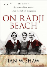
Book - On Radji Beach
This book by Ian Shaw is about the Australian nurses who were evacuated from Singapore after it fell to the Japanese in 1942 and their subsequent fates. Two of the nurses, Wilma Oram and Mona Wilton trained at the Warrnambool Hospital. Wilma Oram survived the war but Mona Wilton, born in Willaura near Warrnambool, was killed when the ship ‘Vyner Brooke’ was sunk by the Japanese in 1942. Mona Wilton was a member of the Australian Army Nursing Service and had been part of the 13th Australian General Hospital unit in Singapore. A Mona Wilton memorial window is now in the Warrnambool Hospital (South West Health Care). This book is of interest as it contains the stories of those Australian nurses who served and died in World War Two after the fall of Singapore in 1942 and in particular it has the stories of those nurses who trained at the Warrnambool Hospital before the advent of war. The story of Mona Winton’s war experiences and her death is of special significance as she was born in the Warrnambool district. This is a soft cover book of 370 pages. The cover has a colour photograph of three nurses on the front and printing on the back. The book contains a prologue, three sections of text, a postscript, a bibliography and an index. A middle section contains several black and white photographs. mona wilton, world war two nurse, world war two, warrnambool -
 Warrnambool and District Historical Society Inc.
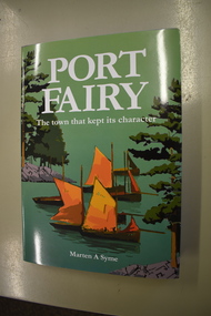
Book, Port Fairy – The Town That Kept Its Character, 2018
This book by Marten Syme is a history of Port Fairy from 1835 to 2018. The earlier histories of Port Fairy do not cover most of the 20th century and none of the 21st century. This book is a scholarly work and offers fresh perspectives on many aspects of Port Fairy history and questions some long-held views, especially on the early years of the town. Port Fairy, 293 kilometres west of Melbourne, has a rich history and is one of the earliest places in Victoria to be settled by Europeans. The author Marten Syme has written extensively on both maritime and local history and is a resident of Port Fairy. This book is of considerable significance as it is a comprehensive history of Port Fairy and complements and adds to the earlier histories of this town. It will be a very useful addition to libraries and will be a great aid to family history and local history researchers.This is a hard cover book of 295 pages. The cover is grey with gold lettering on the spine. The dust cover has white printing and an illustration with a green background with a multi-colour design of sailing ships, trees and harbour entrance. The pages of printed material are in five parts with a bibliography and an index. The book has black and white photographs, maps and other illustrative material. Signature of author (Marten A. Syme)port fairy, marten syme, port fairy -
 Eltham District Historical Society Inc
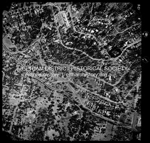
Photograph - Aerial Photograph, Landata, Montmorency / Lower Plenty, Jan. 1973
Centred on 385 Main Road, Lower Plenty bounded by Grand Boulevard, Montmorency to north, Old Eltham Road to south, Bolton Street to east and Panorama Avenue to west. Historic Aerial Imagery Source: Landata.vic.gov.au Aerial Photo Details: Project No :1043 Project : MONTMORENCY Run : 2 Frame : 124 Date : 01/1973 Film Type : B/W Camera : RC8 Flying Height : 2200 Scale : 4000 Film Number : 2722 GDA2020 : 37°43'48"S, 145°07'49"E MGA2020 : 335243, 5822507 (55) Melways : 21 E9 (ed. 42)aerial photo, lower plenty, main road, montmorency, phoebe mason collection, bolton steet, grand boulevard, old eltham road, panorama avenue -
 Eltham District Historical Society Inc
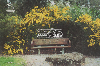
Postcard, Take a seat in history, Alistair Knox Park, Eltham; Celebrating Children's Week 2000, 2000
Postcard as part of a series produced by Shire of Nillumbik for a children's photo project "Nillumbik Naturally" developed by FOCUS FORCE cleebrating Children's Week 2000. Words and photo by Janelle Chambers (Age 13). The logo for the Nillumbik Tourism Assocation Inc is stamped on the front of the postcard. This seat was placed in Alistair Knox Park in commemoration of the end of the Shire of Eltham after Victorian Council amalgamations with the words "Shire of Eltham 1871-1994" included on the back wooden plate of the seat. A similiar seat was placed in the Montmorency Shopping Centre referencing the west riding of the Eltham Shire, which incuded Montmorency. Digital file only - Digitised by EDHS from a scrapbook on loan from Beryl Bradbury (nee Stokes), daughter of Frank Stokes. Also physical postcard (used) alistair knox park, beryl bradbury (nee stokes) collection, janelle chambers, nillumbik tourism association, wattle, seat, children's week, commemoration -
 Bendigo Historical Society Inc.
Document - LONG GULLY HISTORY GROUP COLLECTION: BIRTHPLACES OF THE PEOPLE - MARONG, HUNTLY & STRATHFIELDSAYE
Copies of some pages titled Birthplaces of the People. Tables are divided into each shire under the heading of Bendigo. Birthplaces are divided into British Possessions including Victoria and Foreign Countries including France and French Colonies and Other Fountries, At Sea and Unspecified. Bendigo is divided into Sandhurst City - -?- Ward and Sutton Ward, Eaglehawk Borough and Raywood Borough. Marong Shire is divided into North-West Riding which consists of Newbridge Township, Goldworkings and Outside Township and Goldworkings, Bridgewater Township and Myerstown Township. North-East Riding consists of Kangaroo Flat -?- Goldworkings, Eaglehawk Gully Goldworkings, Eaglehawk Flat Goldworkings, Butcher'sHill Goldworkings, Deadhorse Flat Goldworkings,Myers' Flat Goldworkings and -?- Flat Goldworkings. Maiden Gully Goldworkings, Kangaroo Flar Goldworkings, Epsom Township, Neilborough Township, Whipstick Goldworkings, -?- Goldworkings, Sebastian Goldworkings, Sydney Flat Goldworkings, other Goldworkings, Outside Townships and Goldworkings. South Riding of the Marong Shire consists of Ravenswood Township, Big Hill Township, Grusoe Gully Township, -?- and Lockwood Township. Strathfieldsaye Shire consists of the East Riding and the West Riding which consists of Milkmaid Flat Goldworkings, Diamond Hill Goldworkings, -?-, Sheepwash Gully Goldworkings, Spring Gully Goldworkings, Tin-pot Gully Goldworkings, Golden Gully Goldworkings, Kangaroo Flat and Gully Goldworkings and Outside Goldworkings. Huntly Shire consists of the Huntly Township, Huntly Goldworkings, Ascot Township, -?-, and Outside Townships. Each table lists the number of Persons, Males and Females and the places mentioned earlier where they were born. Black marks on paper make some of it unreadable.bendigo, history, long gully history group, the long gully history group - birthplaces of the people - marong, huntly & strathfieldsaye -
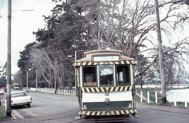 Ballarat Tramway Museum
Photograph - Digital image Set of 10, Stuart Lodington, 1971
Set of 10 digital images of Ballarat trams prior to closure, scanned from original slides by Stuart Lodington, 1971 prior to closure of the system. .1 - No. 32 entering the depot from Wendouree Parade, with the Lake in the background. Shows the depot fire alarm on an adjacent pole. .2 - No. 26 at Sebastopol, before turning the pole. Has a bus stop sign on a pole already. .3 - No. 27 and 26? crossing at the Bell St loop in Skipton St. No. 27 has a Twin Lakes sign. .4 - No. 32 outbound to the Gardens in Hamilton Ave about to enter Wendouree Parade with Loreto convent and Olympic monument the background. .5 - No. 26, Albert St Sebastopol, approaching the Sebastopol terminus, with Sebastopol Food Stores building on the left of the photo. .6 - No. 12 leaving the Parker St. Loop, Sturt St West after crossing a tram. No. 12 has destination of Victoria St. .7 - No. 12 inward bound in Lydiard St North with Fine Art Gallery in the background, 3BA. No. 12 has destination of Sebastopol and has a Twin Lakes sign. .8 - No. 12 inward bound, Sturt St West, No. 12 has destination of Victoria St and has a Twin Lakes sign. .9 - No. 26 at Sebastopol terminus, outside the Royal Mail Hotel, has a bus stop sign on a pole. Tram pole yet to be turned, but destination adjusted to Lydiard St. North. .10 - No. 12 at Sebastopol terminus, outside the Royal Mail Hotel. No. 12 has destination of Lydiard St Nth and has a Twin Lakes sign.trams, tramways, ballarat, sturt st west, sebastopol, skipton st, wendouree parade, hamilton ave, depot, depot junction, parker st loop, bell st, lydiard st nth, tram 32, tram 26, tram 27, tram 12 -
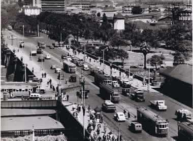 Melbourne Tram Museum
Photograph - Black & White Photograph/s, Australian Govt. Department of Information, late 1940's
Black and white photograph taken from St Pauls Cathedral Melbourne, looking south over Princes Bridge, early 1950's. Has nine trams in the view, mainly W2's, but one W3 and many motor vehicles, trucks etc. Shows the gardens in the now Southbank area, the junction just past the bridge of South Melbourne tram line, Wirth Bros Circus and other buildings, Prince Henry's Hospital. In particular is an Olympic pool direction sign hanging below the Batman Ave tram sign. This would have been the pool in Batman Ave, nearer to Flinders St, within the Flinders St yard complex, not the 1956 pool. Directly below is a female pedestrian dress in the classic 1950's "Dior" look. Over the bridge on the west side is "The Trocadero" formerly The Green Mill Dance Hall opened on 07/09/1926. West of that again is "Olympia" run by Wirth's . In the distance is Prince Henry's Hospital, the tall section was built in 1942, since demolished. Rod Atkins noted that the Olympia burnt down in the early fifties about the same the Trocadia closed, so pre 1953. Note the centre pole is still place at the Sturt Street intersection. In Batman Ave we have two W2's 401 and earlier one. In St Kilda Road we have four W2's in foreground in then W3 - No. 667 then a W4 then a SW6 in the distance. Outbound on route 4D is 578, behind it is 340 on route 5. A safety zone is between 578 and 340.Stamped on rear "Australian Official Photograph / Department of Information" and the number "L3121" in pencil.trams, tramways, swanston st, princes bridge, melbourne, south melbourne, tram 401, tram 667, tram 578 -
 The Beechworth Burke Museum
Audio - Oral History, Jennifer Williams, Mr Alfred Spencer, 17th February 2000
Alfred 'Alf' Spencer grew up on a dairy farm run by his mother, west south west of Beechworth 'down Robertson Road', and was very well connected to the wider Beechworth area. In this oral history, he recalls his time driving the milk cart around Beechworth as well as the time he spent buying lollies and seeing the pictures. He talks extensively about working as a butcher at his brother's store, including how the butchers interacted with the rest of the town and the staff, as well as his time constructing roads and the pipe network of Beechworth. He discusses the dynamics of other workplaces around Beechworth, describing issues with how the local tannery treated its workers as well as how post-war migrants integrated across the town. He briefly discusses racial tensions between Chinese migrants and other miners on the goldfields. He also discusses the experience of health care in a rural area during his childhood. This oral history recording was part of a project conducted by Jennifer Williams in the year 2000 to capture the everyday life and struggles in Beechworth during the twentieth century. This project involved recording seventy oral histories on cassette tapes of local Beechworth residents which were then published in a book titled: Listen to what they say: voices of twentieth century Beechworth. These cassette tapes were digitised in July 2021 with funds made available by the Friends of the Burke.Alfred Spencer's oral history of his life around Beechworth during the 20th century is historically and socially significant to the cultural history of the region and Victoria. There is a lot of detail about workplaces, their staff, and how the resources of the town interacted. He explores themes that are important to Victorian history, such as migration. This oral history account is socially and historically significant as it is a part of a broader collection of interviews conducted by Jennifer Williams which were published in the book 'Listen to what they say: voices of twentieth-century Beechworth.' While the township of Beechworth is known for its history as a gold rush town, these accounts provide a unique insight into the day-to-day life of the town's residents during the 20th century, many of which will have now been lost if they had not been preserved.This is a digital copy of a recording that was originally captured on a cassette tape. The cassette tape is black with a horizontal white strip and is currently stored in a clear flat plastic rectangular container. It holds up to 40 minutes of recordings on each side.Mr Alfred Spencer /listen to what they say, beechworth, oral history, burke museum, spencer, alfred spencer, migration, post-war migration, goldfields, health care, farm, farming, dairy farm, black springs, butchers, meat processing, butcher, road, road network, labour relations -
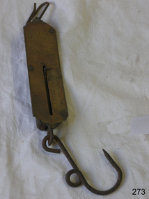 Flagstaff Hill Maritime Museum and Village
Equipment - Spring Balance Scale, George Salter & Co, 1920s
Scales such as the subject item were used to measure commercial quantities, possibly grains and farm produce for quite large amounts of product, also in a domestic situation. Bags of grain or other dry goods would have been hooked up and weighed. Salter has been a name long associated with weights and measures. The firm began life in the late 1760s in the village of Bilston, England when Richard Salter, a spring maker, began making the first spring scales in Britain. He called these scales "pocket steelyards", though they work on a different principle from steelyard balances. By 1825 his nephew George had taken over the company, which became known as George Salter & Co. George later established a manufacturing site in the town of West Bromwich, about 4 miles (7 km) from Bilston. West Bromwich Albion football club was formed from workers at this works site. From here the company produced a wide variety of scales including the UK's first bathroom scales. Other items were added to the range, including irons, mincers, potato chippers, coin-operated machines and the first typewriters made in the UK. The business thrived throughout the 1900s, and by 1950 it employed over 2000 people, still in the same area and owned by the same family.Salter is a British housewares brand developing products that span a wide range of core product categories, including scales, electrical, cookware. It is a market leader in kitchen and bathroom scales and one of the UK’s oldest consumer brands. Established in 1760, Salter has been developing precision products for over 260 years. It was acquired by Manchester-based consumer goods giant Ultimate Products in 2021 after they had previously licensed the brand for cookware and kitchen electrical since 2011.Scale, Salter's improved spring balance, warranted. Brass and iron. Weighs 0 to 25LBS. Long rectangular brass instrument with ring attached to top and hook attached below. Centre of rectangle has long vertical slot with short, horizontal bar that slides down the slot when an object is suspended from the hook, showing its weight on the numbered scale beside the slot.Marked ""SALTER'S IMPROVED SPRING BALANCE" "Number 2". Weighs 0 to 25LBS. flagstaff hill, warrnambool, flagstaff-hill-maritime-museum, maritime-museum, shipwreck-coast, flagstaff-hill-maritime-village, salter balance scale, weight measuring scale, weighing dry goods, domestic object, kitchen scale, measure, weigh, measure ingredients, food preparation -
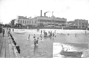 Port Melbourne Historical & Preservation Society
Photograph - Beach at foot of Princes Street, Port Melbourne, c1946 - 47
(From Glen Stuart). Photos taken from Centenary Bridge c1947. HMS Glory (inner East). HMS Implacable (outer East). HMS Indefatigable (outer West). Unknown freighter at Inner West. Ships still in wartime grey and used to transport personnel and equipment back to Australia after the war, before returning to England. PMHPS assume that these five photos (3354.01 - .05) were taken on the same day. See Glen Stuart's comment above although this photo has been taken from the Princes Street jetty beside Centenary Bridge looking back towards Beach Street. HMS Glory, Implacable and Indefatigable with attendant destroyers Tuscan and Armada arrived in Port Melbourne on 23 January 1946 and returned to England in 1947. [This series of photos 3354.01 - .05 as well as 3361 and 3362 came to PMHPS from the Moe Historical Society via the St Kilda Historical Society. Notations in pencil on the back along the left had edge indicate they came from "C W Ward photo, 355 High St, Prahran, Melbourne". Each photo bears the date 9-12-1947 in the top left corner. It is not known what this date refers to. Possibly it is when the photo was printed. Another notation on each photo says "Port Melbourne, taken in 1920". This is definitely incorrect and "NOT" has been written underneath this comment.]View from Princes Street jetty of London Family Hotel, Swallow and Ariell & children bathing. Small photo of Boat No 9 has been pasted at corner. C W Ward photo, 355 High St, Prahran, Melbournebeach street, natural environment - beaches and foreshore, built environment - commercial, london family hotel, swallow & ariell ltd, business and traders - hotels -
 Melbourne Tram Museum
Ephemera - Timetables - MMTB Buses, Melbourne & Metropolitan Tramways Board (MMTB)
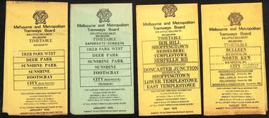
Timetables - provide information on ticketing, fares, timing points, with a description of the route and a map. Not all services had been allocated a route number at the time. 1 - Deer Park West - Sunshine - Footscray - City - Jan 1975, including a separate weekend timetable' 2 - Box Hill - Shoppingtown - Templestowe - May 1975 3 - Bulleen - North Kew City - Routes 203, 204, 205, 206, 208 and 209 - August 1972 4 - North Altona - City - route 232 - June 1979 5 - Clifton Hill - Elsternwick route - route 246, Point Ormond - route 247 and 248 - June 1974 6 - La Trobe University - Northland - West Heidelberg - City - routes 256, 251, 253, 254, 252, 255 - August 1974 7 - Warrandyte - Park Orchards - Ringwood - routes 273, 274, 275 - Feb. 1974 8 - Warrandyte - Donvale - Templestowe - Shoppingtown - City - routes 276, 277, 278, 294, 278, 280, 299, 268 - April 1975 9 - East Kew, Box Hill Doncaster, Shoppingtown - routes 284, 285, 270 - May 1974 10 - Box Hill - Mitcham, East Doncaster, Ringwood - routes 287, 286, 288, 282, 283, 272 - March 1974' 11 - Box Hill - North Blackburn - route 290 - March 1974 12 - Fishermans Bend - City - routes 233, 235, 237 - Feb 1979.Yields information about MMTB Bus services during the 1970s.Set of twelve MMTB Bus timetables - multifolded printed on yellow paper, except for Deer Park timetables for Saturdays and Sundays printed on green paper.timetable, the met, buses, box hill, doncaster, templestowe, warrandyte, elsternwick, fishermans bend, deer park, altona, sunshine, footscray, shoppingtown -
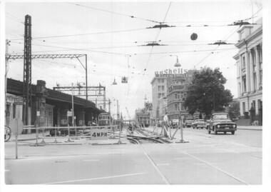 Melbourne Tram Museum
Photograph - Set of 12 - construction of King St overpass in Flinders St, 1959
Photos show the construction of King St overpass in Flinders St which was part of the project to construct a bridge over the Yarra River and provide a new southern outlet road between the city and eventually St Kilda Junction. The overpass construction was commenced in 1959 with tramway works first commencing. It was demolished in 2005. 1 - looking west at Market St. 2 - looking east from Spencer and Flinders St with the railway viaduct behind. 3 - Tram lines diverted onto the new overpass. Note the hand-powered overhead tower on the left behind the compressor. 4 - Tracks partially diverted. 5 - Looking east at Spencer and Flinders St with a Dunlop tyre truck in the view. 6 - prior to the diversion onto the new bridge. 7 - Looking east near William St. with W2 451 (Route 48, North Balwyn) in the view. 8 - Bridge works near King St. Original tracks still in use. 9 - Looking east prior to the introduction of the temporary tracks on the south side of the new overpass. 10 - SW6 852 and a W2 on new overpass trackwork - old trackwork being demolished. 11 - Cross over at Spencer St in Flinders St, prior to change over. 12 - Looking west at Flinders and Spencer St with SW6 853 turning into Spencer St.Yields information about the construction of the King St overpass in Flinders St during 1959.Set of 12 black and white prints of the construction of the King St overpass in Flinders St.trams, tramways, flinders st, king st overpass, construction, bridges, w2 class, sw6 class, tram 451, tram 853, tram 852 -
 Melbourne Tram Museum
Ephemera - Timetable/s, Melbourne & Metropolitan Tramways Board (MMTB), "MMTB Bus Timetables", 1983
Timetables for specific routes, day of week giving information on tram times at specific time points, route map, sections and fares and organisation address - 616 Little Collins St. Melbourne. All printed on yellow paper unless noted otherwise. .1 - Route 220 and 231 - Sunshine - Footscray - City - March 1983 .2 - North Altona - City via West Gate Freeway - April 1983 .3 - Route 257, 258, 259 - West Heidelberg, Northland, Latrobe University - City - July 1983 .4 - ditto .5 - Route 265, 262, 261, 260, 266, 264 - Warrandyte, Templestowe, Doncaster, Park Orchard - Donvale - City - Feb. 1983 .6 - Route 277, 280, 299, 281 and 268 - Warrandyte, East Doncaster, Donvale, Shoppingtown - July 1983 .7 - Route 287, 286, 302, 303 Box Hill, Mitcham, East Doncaster, Mitcham, Ringwood - June 1980 .8 - ditto - but November 1983 .9 - Route 313, 314, 315, 316 - Warrandyte, Park Orchards, Mitcham - Jan. 1983 .10 - as for .8 11 - Routes 265, 262, 261,260, 266 and 264 - Warrandyte - Eastern Freeway, Templestowe, Park Orcards - Feb. 1983 12 - Routes 277, 280, 281 and 268 - East Doncaster, Donvale, City and Shoppingtown - Jan. 1983 Items .3, .4, .6, .8 and .10 are headed "Metropolitan Transit", rest MMTB.Yields information about MMTB Bus Services 1983Set of 12 MMTB or Metropolitan Transit Bus timetables, folded sheets, generally 10 sections.trams, tramways, mmtb, timetables, melbourne, fares, buses, deer park, sunshine, footscray, latrobe university, northland, heidelberg, box hill, warrandyte, doncaster, donvale, mitcham, ringwood, park orchards -
 Melbourne Tram Museum
Ephemera - Timetables - MMTB Buses - set of 9, Melbourne & Metropolitan Tramways Board (MMTB), 1976 to 1978
Timetables - provide information on ticketing, fares, timing points, with a description of the route and a map. Not all services had been allocated a route number at the time. 1 - Garden City - Port Melbourne - City - routes 201 and 202 - Jan. 1977 2 - Bulleen - North Kew City - Routes 203, 204, 205, 206, 208 and 209 - Feb. 1977 3 - Deer Park West - Sunshine - Footscray - City - routes 215, 216, 217, 219. 218, 220, 231 with a Saturdays and Sundays timetable sheet printed on green paper - Aug. 1977 4 - La Trobe University - Northland - West Heidelberg - City - routes 256, 251, 253, 254, 252, 255 - Sept. 1978 5- Warrandyte - Park Orchards - Ringwood - routes 273, 274, 275 - June 1976 6 - Warrandyte - Donvale - Templestowe - Shoppingtown - City - routes 276, 277, 278, 294, 278, 280, 299, 268 - July 1976 7 - Box Hill - Mitcham, East Doncaster, Ringwood - routes 287, 286, 288, 282, 283, 272 - June 1976 8 - Box Hill - North Blackburn - route 290 - June 1976 9 - Box Hill - Heidelberg, East Doncaster, Shopping town - routes 291, 297, 296, 293, 271 and 269 - Sept. 1976Yields information about MMTB Bus services during the mid 1970s. Set of nine MMTB Bus timetables - multifolded printed on yellow paper, unless noted otherwise. timetable, mmtb, buses, port melbourne, garden city, deer park, fisherman's bend, west heidelberg, box hill, doncaster, shoppingtown, mitcham, ringwood, blackburn, templestowe, lower templestowe -
 Port Melbourne Historical & Preservation Society
Photograph - Station Pier Gatehouse, c1946 - 47
(From Glen Stuart). Photos taken from Centenary Bridge c1947. HMS Glory (inner East). HMS Implacable (outer East). HMS Indefatigable (outer West). Unknown freighter at Inner West. Ships still in wartime grey and used to transport personnel and equipment back to Australia after the war, before returning to England. PMHPS assume that these five photos (3354.01 - .05) were taken on the same day. See Glen Stuart's comment above although this photo has been taken on the pier looking back through the gatehouse towards Centenary Bridge. HMS Glory, Implacable and Indefatigable with attendant destroyers Tuscan and Armada arrived in Port Melbourne on 23 January 1946 and returned to England in 1947. [This series of photos 3354.01 - .05 as well as 3361 and 3362 came to PMHPS from the Moe Historical Society via the St Kilda Historical Society. Notations in pencil on the back along the left had edge indicate they came from "C W Ward photo, 355 High St, Prahran, Melbourne". Each photo bears the date 9-12-1947 in the top left corner. It is not known what this date refers to. Possibly it is when the photo was printed. Another notation on each photo says "Port Melbourne, taken in 1920". This is definitely incorrect and "NOT" has been written underneath this comment.]Station Pier Gatehouse from waterside with bunting and a "Thank You" sign attached. Pedestrians walking towards Centenary Bridge. c1946 - 47C W Ward photo, 355 High St, Prahran, Melbournepiers and wharves - station pier, war - world war ii, centenary bridge -
 Melbourne Tram Museum
Ephemera - Timetable, Melbourne & Metropolitan Tramways Board (MMTB), MMTB Tram timetables, set of 12, 1971
Timetables for specific routes, day of week giving information on tram times at specific time points, route map, sections and fares and organisation address - 616 Little Collins St. Melbourne. 1 - Glen Iris - City route 6 - Oct. 1971 2 - North Coburg with connecting bus to Fawkner and Gowrie - Upfield on Sundays - June 1971 3 - Mont Albert - City - routes 42, 44, 45, 37 - Oct. 1971 4 - West Coburg - Domain Road and West Coburg City on Sundays - routes 55, 56 and 68 - May 1971 5 - Essendon Aerodrome - City route 59 - June 1971 6 - East Brighton - City - routes 64, 65, 62, 61 - Oct. 1971 7 - Carnegie - City - routes 67, route 66 - Oct. 1971 8 - Wattle Park - City route 70, route 71 and route 76 - Oct. 1971 9 - Camberwell - City - route 72, route 73 - Oct. 1971 10 - Prahran - City, North Richmond -Prahran - St Kilda Beach, routes 77, 78 and 79 - Oct. 1971 11 - East Preston - City and East Brunswick - City - routes 88, 89, 90. 96 and 97 - Oct. 1971 12 - ditto for Sundays printed on green paper. 13 - Route 8, Toorak, Oct. 1971-*Yields information about 1971 MMTB timetables.Set of 12 1971 MMTB Tram timetables, folded sheets.trams, tramways, timetables, mont albert, route 42, route 6, route 19, upfield, route 44, route 45, route 37, route 55, route 56, route 68, route 59, route 64, route 65, route 62, route 61, route 67, route 66, route 70, route 71, route 76, route 72, route 73, route 77, route 78, route 79, route 88, route 90, route 96, route 97, route 8 -
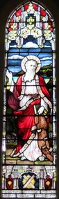 Christ Church Anglican Parish of Warrnambool
Memorial window: Rev Andrew PEACOCK, "I will make you fishers of men"
Stained glass window, south wall, main nave (adjacent to the pulpit). The window is a pictorial representation of St Andrew who live to old age. There is a tradition that on being sentenced to death, he requested that he be crucified on a saltire (diagonal cross, see base of window) as he felt unworthy to be crucified on the vertical cross of Christ. Another symbol of association with St Andrew is the fishing net.The Rev. Andrew Peacock, Archdeacon of the Otways, was the fourth Vicar (1906-1912) of the Parish of Warrnambool. He was highly regarded throughout the community and died following a very short illness. His brother, Sir Alexander Peacock, three times premier of Victoria, officially unveiled a tablet on the north-west corner of the Parish Hall complex on Saturday 25th April and attended the dedication of the memorial window on Sunday 26th April 1913. Rev AE Peacock is buried at Creswick cemetery, Victoria. -
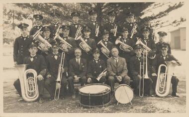 Phillip Island and District Historical Society Inc.
Photograph, 1932
Donated by Stan McFee from the Keith McIlwraith Collection.Black & White photograph of 22 members of the Phillip Island Band posed in front of tree with instruments.On Back: "Phillip Island Band 1932" Left to Right: Front row: H. Watchorn. N. McLardy, R. Scott Pres., H. Warren (Band Master), D. Robb, Ray Richardson, A Bauer, Middle row: A. Murray, Noel Cleeland, J. McLardy, R. De La Haye, C. Leeson, A. Towns, Goerson, W. Little. Back row: P. Double, B. West, A. Morrison, C. Williams, F. Towns, H. De La Haye, Keith McIlwraith.phillip island band, brass bands, keith mcilwraith collection, stan mcfee, phillip island -
 Ringwood and District Historical Society
Photograph, Ringwood's first post office showing first postmistress, Miss M. Thompson. 1890
Typed below photograph, "Ringwood's first Post Office showing first Postmistress, Miss M. Thompson and her mother. 1890". (South side of Main Street (Maroondah Highway), approximately 300 meters west of Ringwood Railway Station). Writing on back of original photograph reads, "Grandma and Auntie Martha Thomson 1890". Stamps on back of photograph read, "Wall Bros. Photographers ... St. Kilda". Other stamp reads, "R.J.T. Futcher, Geelong, Victoria, Australia". -
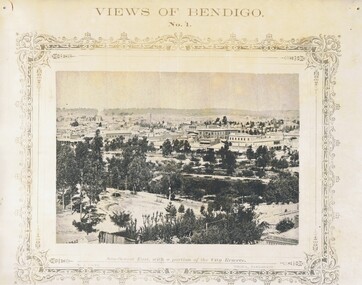 Bendigo Historical Society Inc.
Photograph - NICHOLAS CAIRE VIEWS OF BENDIGO
Full set (52 photos) of Nicholas Caire ''Views of Bendigo'' photographs. 1) Sandhurst East with a portion of the City Reserve. 2) New Chum line of reef. 3) Sandhurst-North part as seen from the top of the Masonic Hall. 4) The Hustler's line of reef seen from Redan Hill. 5) Battery of stampers for crushing quartz 6) View of Sandhurst as seen from the top of the New Masonic Hall. 7) Excavation of quartz reef near Ironbark Hill. 8) St. Paul's Church, tower and belfry. 9) View of the Camp Reserve as seen from the Court House. 10) View of North Old Chum showing surface excavations. 11) View as seen from the Camp Hill near the lodge. 12) Garden Gully amalgamated claims. 13) Shamrock Hotel, Sandhurst. 14) View as seen from Court House showing the willows & East Pall Mall. 15) Wesleyan Church, Golden Square. 16) Savings bank, Sandhurst. 17) The Bendigo district hospital. 18) Interior of the Wesleyan Church, Golden Square. 19) View of Golden Square township. 20) The Town Hall, City of Sandhurst. 21) The City Hotel, Sandhurst. 22) Pall Mall, Sandhurst. 23) Sandhurst City Market. 24) Pall Mall, Sandhurst looking west. 25) View from Camp Hill looking north - east 26) View of Charing Cross, Sandhurst. 27) View of Sandhurst as seen from Knipe's Castle. 28) Township of Long Gully. 29) View taken from St. Paul's tower. 30) View of the Sandhurst cemetery at back creek. 31) Kock's pioneer quartz crushing plant, Long Gully. 32) The New Masonic Hall, Sandhurst. 33) The Bendigo benevolent asylum and industrial school. 34) Bendigo flat as seen from Wattle Hill. 35) View of Old Chum Hill. 36) New Chum Gully as seen from Specimen Hill. 37) Township of Eaglehawk. 38) View from St. Paul's tower looking south west. 39) View of the railway tunnel through the Big Hill, near Mt. Herbert. 40) View taken from St. Paul's looking south. 41) Scene taken from St. Paul's tower looking eastward. 42) View of Sandhurst from St. Paul's tower looking north-west. 43) The great extended Hustler's co's. quartz mining claim. 44) View from the Big Hill showing the line of railway to Melbourne. 45) View from St. Paul's Church tower looking westward. 46) View from St. Paul's Church tower looking north-west. 47) Scene near the Big Hill ranges taken from Mr. Buick's residence. 48) View from St. Paul's Church tower looking north eastward. 49) Township of Eaglehawk 50) View of Mitchell Street, Sandhurst. 51) Botanical gardens near the White Hills. 52) View Point, Sandhurst.bendigo, streetscape, various views, nicholas cairne -
 Melbourne Tram Museum
Ephemera - Timetable/s, Melbourne & Metropolitan Tramways Board (MMTB), "MMTB Timetables set of 39", 1960
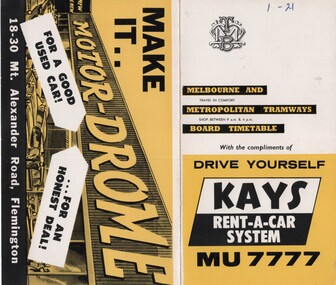
Set of 39 MMTB Tram timetables, 2 fold sheets, , providing timetables for specific routes, route numbers, day of week giving information on tram times at departure time points, sections and fares, where applicable all night bus services. All signed by B. H. Misson, Traffic Manager. All sponsored by Kays Rent a Car and Motor Drome, 18-30 Mount Alexander Road, Flemington. The only one missing is Point Ormond. Not dated, based on fares - 1960 and possibly after Point Ormond had closed. .1 - Route 1, 21 - East Coburg - City .2 - Route 4, 4A, 4B - Carnegie - City .3 - Route 4D, 14 - East Malvern - City .4 - Route 5, 5A - Malvern Burke Road - City .5 - Route 6, 6A, 6B - Glen Iris - City .6 - Route 7, 7A, 7B, 7D - Camberwell - City .7 - Route 8, 8A - Toorak - City .8 - Route 9, 9A - Northcote via St Georges Road - City .9 - Route 9, 9B, 10, 12 - Sth Melbourne Beach, St Kilda Beach - City .10 - Route 10,11 - West Preston - City .11 - Route 15, 16 - St Kilda Beach - City .12 - Route 15, 22 - Moreland - City .13 - Route 18, 19, 20 - North Coburg - City .14 - Route 27, 28 - Hawthorn - Spencer St .15 - Route 42, 44, 45 - Mont Albert - City .16 - Route 48, 40, 41 - North Balwyn - Spencer St .17 - Route 49 - Essendon (Matthews Ave) - City .18 - Route 50, 54, 57, 58, 60 - West Maribyrnong - City .19 - Route 55, 56 - West Coburg - City .20 - Route 59 - Essendon Aerodrome - City .21 - Route 61, 62, 64, 65 - East Brighton - City .22 - Route 69 - Kew Cotham Road - St Kilda Beach .23 - Route 70, 71, 76 - Wattle Park - City .24 - Route 74, 75, 76 - Burwood - City .25 - Route 77, 80 - Prahran - City .26 - Route 78, 79 - North Richmond - Prahran .27 - Route 82 - Moonee Ponds - Footscray .28 - Williamstown Road - Footscray - Tram and bus .29 - Ballarat Road - Footscray - Tram and bus .30 - Russell St - - Footscray - Tram and bus .31 - East Brunswick - City .32 - Domain Road - City .33 - West Heidelberg - City .34 - Sunshine - City via Ballarat and Footscray Roads .35 - Sunshine - City via South and Dynon Roads .36 - Sunshine Park - City .37 - Garden City - City (Victoria St) .38 - Queens Bridge - Fisherman's Bend via Ingles St .39 - Queens Bridge - Fisherman's Bend via Lorimer St and Princes Bridge - Fisherman's Bend via Williamstown Rd.All have the route number in ink on the front cover - see image 5691i.jpg for standard cover.trams, tramways, mmtb, timetables, melbourne, fares, route 1, route 22, route 4, route 4a, route 4b, route 4d, route 14, route 5, route 5a, route 6, route 6a, route 6b, route 7, route 7a, route 7b, route 7d, route 8, route 8a, route 9, route 9a, route 9b, route 10, route 11, route 12, route 15, route 16, route 22, route 18, route 19, route 20, route 27, route 28, route 42, route 45, route 44, route 48, route 40, route 41, route 49, route 50, route 54, route 57, route 58, route 60, route 52, route 56, route 59, route 61, route 62, route 64, route 65, route 69, route 70, route 71, route 76, route 74, route 75, route 76, route 77, route 80, route 78, route 79, route 82, williamstown rd, ballarat rd, russell st, route 96, domain rd, west heidelberg, sunshine, garden city, queens bridge, fishermen's bend -
 Flagstaff Hill Maritime Museum and Village
Photograph
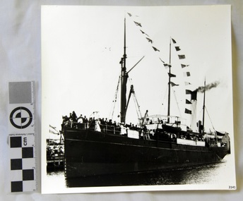
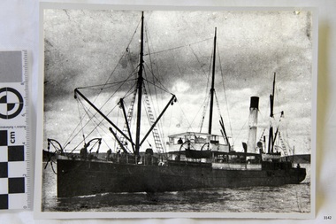
Black and White Photograph of S.S Casino arriving in Port. Taken 1930-1932. People on the deck and on the river banks waving. Smoke coming from funnel. The S.S. Casino was a passenger and freight steamer built in Dundee, Scotland, in 1882 for the Newcastle and Hunter River Steam Navigation Company of N.S.W. She weighed 425 tons gross with a length of 160.4 feet, beam of 24.1 feet and depth of 10.2 feet. She had saloon accommodation for 35 people, forecabin for 25 more people, and she carried 300 tons of cargo. While on her delivery journey on May 30th 1882 the S.S. Casino called in at the Port of Warrnambool for coal ., narrowly escaping going ashore in gale force winds due to the quick action of the pilot. At that time, still at anchor, she impressed the directors of the Belfast and Koroit Steam Navigation Company so much that they bought her immediately; she was ideal for trade in along the West Coast of Victoria. (Belfast is the original name for Port Fairy, South West Victoria. The Belfast and Koroit Steam Navigation Company was first managed by Messers. Saltau and Osburne and after the passing of Mr. Osburne, by produce merchants Messers H. Sautau and Sons, whose had a hay and corn store and shipping agency was on the corner of Liebig and Koroit Streets in Warrnambool. ) The S.S. Casino became “the most famous steamer to operate in Victorian waters along the West Coast” by author Jack Loney. Captain Boyd was her first Master, followed by Captain Chapman, who stayed with her 1890 until 1924. Captain W. Robertson followed for a short term, then Captain Middleton then took command 1925 - 1932. The S.S. Casino had several mishaps during her life. One was on 3rd January 1898 when she collided with the S.S. Flinders in Apollo Bay with minor damage. Another was on 24th October 1924 when she grounded on a reef at Point Hawdon near Grey River and most of her cargo (of Christmas goods) had to be dumped into the sea. Then in February 1929 she was ‘holed’ when she struck a submerged object as she entered Lady Bay, Warrnambool. On the morning of 10th July 1932, after attempting to berth at Apollo Bay jetty in heavy seas, Captain Middleton decided to take her out into the bay and wait until the seas abated. It was not realised that the anchor used to steady her as she manoeuvred to her berth had pierced her hull. She put about and headed for the beach but sank. Captain Middleton and nine others lost their lives; nine people were rescued including the two female passengers . Captain Middleton had been in charge of the S.S. Casino for seven years. He was the first ship’s Master to lose his life through shipwreck in the West Coast trade. In the years following the turn of the century the S.S. Casino remained the only regular trader with normal passenger accommodation along the West Coast. From 1882 she had made at least 2,500 voyages on the one run. Flagstaff Hill’s collection has a photograph of a portrait of Captain Chapman, , a ship model of the S.S. Casino that shows both forms of power under which she sailed, steam and sail. The ship is painted green and flies three flags. The inscription across the case of the ship model, incorrectly dated, tells the sad story of the wreck of the ship and the loss of lives on July 10th 1932 at Apollo Bay. A print in the Collection show S.S. Casino underway in heavy sea off Point Lonsdale, another two photographs show her at the Port of Warrnambool, leaving from the Breakwater in Lady Bay and another identifies the S.S. Casino as a ship from the Belfast and Koroit Steam Navigation Company. (Belfast is the original name for the township of Port Fairy). This photograph is significant because of its association with the coastal trader S.S. Casino 1930 -1932 and its significance to trade along Victoria's West Coast in the late 19th and early 20th century. The wreck of the S.S. Casino is considered an important part of Victorian and Australian cultural heritage and as such has been declared and protected as an Historic Shipwreck Black and White Photograph of S.S Casino arriving in Port. Taken 1930-1932. People on the deck and on the river banks waving. Smoke coming from funnel.flagstaff hill, warrnambool, shipwrecked coast, flagstaff hill maritime museum, maritime museum, shipwreck coast, flagstaff hill maritime village, great ocean road, newcastle and hunter river steam navigation company, belfast and koroit steam navigation company, h. sautau and sons, s.s. casino, west coast trader s.s. casino, victorian coastal trader, captain boyd, captain w. robertson, captain chapman, captain middleton, apollo bay shipwreck, s.s. casino at lady bay warrnambool, saltau and osburne -
 Flagstaff Hill Maritime Museum and Village
Photograph
Black and White Photograph of S.S Casino taken 1930-1932. Ship has men on deck and a man at the helm. Hills and the shore can be seen in the background. The S.S. Casino was a passenger and freight steamer built in Dundee, Scotland, in 1882 for the Newcastle and Hunter River Steam Navigation Company of N.S.W. She weighed 425 tons gross with a length of 160.4 feet, beam of 24.1 feet and depth of 10.2 feet. She had saloon accommodation for 35 people, forecabin for 25 more people, and she carried 300 tons of cargo. While on her delivery journey on May 30th 1882 the S.S. Casino called in at the Port of Warrnambool for coal ., narrowly escaping going ashore in gale force winds due to the quick action of the pilot. At that time, still at anchor, she impressed the directors of the Belfast and Koroit Steam Navigation Company so much that they bought her immediately; she was ideal for trade in along the West Coast of Victoria. (Belfast is the original name for Port Fairy, South West Victoria. The Belfast and Koroit Steam Navigation Company was first managed by Messers. Saltau and Osburne and after the passing of Mr. Osburne, by produce merchants Messers H. Sautau and Sons, whose had a hay and corn store and shipping agency was on the corner of Liebig and Koroit Streets in Warrnambool. ) The S.S. Casino became “the most famous steamer to operate in Victorian waters along the West Coast” by author Jack Loney. Captain Boyd was her first Master, followed by Captain Chapman, who stayed with her 1890 until 1924. Captain W. Robertson followed for a short term, then Captain Middleton then took command 1925 - 1932. The S.S. Casino had several mishaps during her life. One was on 3rd January 1898 when she collided with the S.S. Flinders in Apollo Bay with minor damage. Another was on 24th October 1924 when she grounded on a reef at Point Hawdon near Grey River and most of her cargo (of Christmas goods) had to be dumped into the sea. Then in February 1929 she was ‘holed’ when she struck a submerged object as she entered Lady Bay, Warrnambool. On the morning of 10th July 1932, after attempting to berth at Apollo Bay jetty in heavy seas, Captain Middleton decided to take her out into the bay and wait until the seas abated. It was not realised that the anchor used to steady her as she manoeuvred to her berth had pierced her hull. She put about and headed for the beach but sank. Captain Middleton and nine others lost their lives; nine people were rescued including the two female passengers . Captain Middleton had been in charge of the S.S. Casino for seven years. He was the first ship’s Master to lose his life through shipwreck in the West Coast trade. In the years following the turn of the century the S.S. Casino remained the only regular trader with normal passenger accommodation along the West Coast. From 1882 she had made at least 2,500 voyages on the one run. Flagstaff Hill’s collection has a photograph of a portrait of Captain Chapman, , a ship model of the S.S. Casino that shows both forms of power under which she sailed, steam and sail. The ship is painted green and flies three flags. The inscription across the case of the ship model, incorrectly dated, tells the sad story of the wreck of the ship and the loss of lives on July 10th 1932 at Apollo Bay. A print in the Collection show S.S. Casino underway in heavy sea off Point Lonsdale, another two photographs show her at the Port of Warrnambool, leaving from the Breakwater in Lady Bay and another identifies the S.S. Casino as a ship from the Belfast and Koroit Steam Navigation Company. (Belfast is the original name for the township of Port Fairy). This ohotograph is significant because of its association with the coastal trader S.S. Casino 1882-1932 and its significance to trade along Victoria's West Coast in the late 19th and early 20th century. The wreck of the S.S. Casino is considered an important part of Victorian and Australian cultural heritage and as such has been declared and protected as an Historic Shipwreck under State and Commonwealth Law in the Commonwealth Historic Shipwrecks Act (1976). Black and White Photograph of S.S Casino taken 1932-1932. Ship has men on deck and a man at the helm. Hills and the shore can be seen in the background.flagstaff hill, warrnambool, shipwrecked coast, flagstaff hill maritime museum, maritime museum, shipwreck coast, flagstaff hill maritime village, great ocean road, newcastle and hunter river steam navigation company, belfast and koroit steam navigation company, h. sautau and sons, s.s. casino, west coast trader s.s. casino, victorian coastal trader, captain boyd, captain w. robertson, captain chapman, captain middleton, apollo bay shipwreck, s.s. casino at lady bay warrnambool, saltau and osburne -
 Flagstaff Hill Maritime Museum and Village
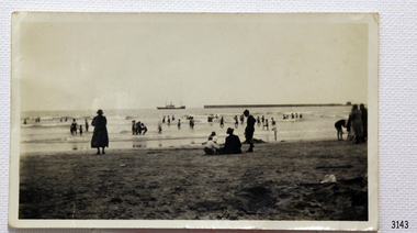
Photograph - Coastal Scene, 1930-1932
The black and white photograph is a typical beach scene taken at Lady Bay, Warrnambool, between 1930 and 1932. In the background is the coastal trader, the steamship SS Casino. Adults and children are in the foreground, playing on the beach and in the water. The Warrnambool Breakwater is on the horizon. The S.S. Casino was a passenger and freight steamer built in Dundee, Scotland, in 1882 for the Newcastle and Hunter River Steam Navigation Company of N.S.W. The vessel weighed 425 tons gross with a length of 160.4 feet, a beam of 24.1 feet and a depth of 10.2 feet. Accommodation for 35 people was provided in the saloon, and 25 passengers in the fore-cabin, plus room for 300 tons of cargo. On May 30th 1882 the S.S. Casino called in at the Port of Warrnambool for coal, narrowly escaping being swept ashore in gale-force winds due to the pilot's quick action. At that time, still at anchor, the directors of the Belfast and Koroit Steam Navigation Company were so impressed that they bought the S S Casino immediately; being ideally suited for trade along the West Coast of Victoria; Belfast is the original name for Port Fairy, South West Victoria. The Belfast and Koroit Steam Navigation Company was first managed by Messers Saltau and Osburne, and after the passing of Mr Osburne, by produce merchants Messers H. Sautau and Sons, owners of a hay and corn store and shipping agency was on the corner of Liebig and Koroit Streets in Warrnambool. The S.S. Casino was named “the most famous steamer to operate in Victorian waters along the West Coast” by maritime author Jack Loney. Captain Boyd was her first Master, followed by Captain Chapman, who stayed with her from 1890 until 1924. Captain W. Robertson followed for a short term, and then Captain Middleton took command from 1925 to 1932. The S.S. Casino had several mishaps during her life. One was on 3rd January 1898 when the ship collided with the S.S. Flinders in Apollo Bay with minor damage. Another was on 24th October 1924 when the Casino was grounded on a reef at Point Hawdon near Grey River and most of her cargo of Christmas goods had to be dumped into the sea. Then in February 1929, the Casino was ‘holed’ when it struck a submerged object as it entered Lady Bay, Warrnambool. On the morning of 10th July 1932, after attempting to berth at Apollo Bay jetty in heavy seas, Captain Middleton decided to take S S Casino out into the bay and wait until the seas abated. It was not realised that the anchor that steadied the ship during a manoeuver had pierced its hull, and it sank as it headed for the beach. Captain Middleton and nine others lost their lives, but nine people were rescued including the two female passengers. Captain Middleton had been in charge of the S.S. Casino for seven years. He was the first ship’s Master to lose his life in a shipwreck in the West Coast trade. In the years following the turn of the century, the S.S. Casino remained the only regular trader with normal passenger accommodation along the West Coast. From 1882 it had made at least 2,500 voyages on the one run. Flagstaff Hill’s collection has a portrait photograph of Captain Chapman, a ship model of the S.S. Casino that shows both forms of power under which it sailed, steam and sail. The ship is painted green and flies three flags. The inscription across the case of the ship model, incorrectly dated, tells the sad story of the wreck of the ship and the loss of lives on July 10th 1932 at Apollo Bay. A print in the Collection shows S.S. Casino underway in the heavy sea off Point Lonsdale, another two photographs show it at the Port of Warrnambool, leaving from the Breakwater in Lady Bay, and another identifies the S.S. Casino as a ship from the Belfast and Koroit Steam Navigation Company.The photograph shows an example of the Warrnambool community and family bathing and beach activities of the 1930s. The photograph is significant because of its association with the coastal trader S.S. Casino 1882-1932 and its significance to cargo and passenger trade along Victoria's West Coast in the late 19th and early 20th centuries. The wreck of the S.S. Casino is considered an important part of Victorian and Australian cultural heritage and as such has been declared and protected as a Historic Shipwreck under State and Commonwealth Law in the Commonwealth Historic Shipwrecks Act (1976). Black and white photograph of steamship S.S Casino. Taken from the beach, adults and children on shore and in the water. Circa 1930-1932.newcastle and hunter river steam navigation company, belfast and koroit steam navigation company, h. sautau and sons, s.s. casino, west coast trader s.s. casino, victorian coastal trader, captain boyd, captain w. robertson, captain chapman, captain middleton, apollo bay shipwreck, lady bay warrnambool, saltau and osburne, port of warrnambool, warrnambool breakwater, beach, bathing, 1039, 1931, 1932, beach scene, swim -
 Flagstaff Hill Maritime Museum and Village
Photograph - Coastal Scene, 1930-1932
The black and white photograph is a typical beach scene taken at Lady Bay, Warrnambool, between 1930 and 1932. In the background is the coastal trader, the steamship SS Casino. Adults and children are in the foreground, playing on the beach and in the water. The old jetty is on the left and the Warrnambool Breakwater is on the horizon. The S.S. Casino was a passenger and freight steamer built in Dundee, Scotland, in 1882 for the Newcastle and Hunter River Steam Navigation Company of N.S.W. The vessel weighed 425 tons gross with a length of 160.4 feet, a beam of 24.1 feet and a depth of 10.2 feet. Accommodation for 35 people was provided in the saloon, and 25 passengers in the fore-cabin, plus room for 300 tons of cargo. On May 30th 1882 the S.S. Casino called in at the Port of Warrnambool for coal, narrowly escaping being swept ashore in gale-force winds due to the pilot's quick action. At that time, still at anchor, the directors of the Belfast and Koroit Steam Navigation Company were so impressed that they bought the S S Casino immediately; being ideally suited for trade along the West Coast of Victoria; Belfast is the original name for Port Fairy, South West Victoria. The Belfast and Koroit Steam Navigation Company was first managed by Messers Saltau and Osburne, and after the passing of Mr Osburne, by produce merchants Messers H. Sautau and Sons, owners of a hay and corn store and shipping agency was on the corner of Liebig and Koroit Streets in Warrnambool. The S.S. Casino was named “the most famous steamer to operate in Victorian waters along the West Coast” by maritime author Jack Loney. Captain Boyd was her first Master, followed by Captain Chapman, who stayed with her from 1890 until 1924. Captain W. Robertson followed for a short term, and then Captain Middleton took command from 1925 to 1932. The S.S. Casino had several mishaps during her life. One was on 3rd January 1898 when the ship collided with the S.S. Flinders in Apollo Bay with minor damage. Another was on 24th October 1924 when the Casino was grounded on a reef at Point Hawdon near Grey River and most of her cargo of Christmas goods had to be dumped into the sea. Then in February 1929, the Casino was ‘holed’ when it struck a submerged object as it entered Lady Bay, Warrnambool. On the morning of 10th July 1932, after attempting to berth at Apollo Bay jetty in heavy seas, Captain Middleton decided to take S S Casino out into the bay and wait until the seas abated. It was not realised that the anchor that steadied the ship during a manoeuver had pierced its hull, and it sank as it headed for the beach. Captain Middleton and nine others lost their lives, but nine people were rescued including the two female passengers. Captain Middleton had been in charge of the S.S. Casino for seven years. He was the first ship’s Master to lose his life in a shipwreck in the West Coast trade. In the years following the turn of the century, the S.S. Casino remained the only regular trader with normal passenger accommodation along the West Coast. From 1882 it had made at least 2,500 voyages on the one run. Flagstaff Hill’s collection has a portrait photograph of Captain Chapman, a ship model of the S.S. Casino that shows both forms of power under which it sailed, steam and sail. The ship is painted green and flies three flags. The inscription across the case of the ship model, incorrectly dated, tells the sad story of the wreck of the ship and the loss of lives on July 10th 1932 at Apollo Bay. A print in the Collection shows S.S. Casino underway in the heavy sea off Point Lonsdale, another two photographs show it at the Port of Warrnambool, leaving from the Breakwater in Lady Bay, and another identifies the S.S. Casino as a ship from the Belfast and Koroit Steam Navigation Company.The photograph shows an example of the Warrnambool community and family bathing and beach activities of the 1930s. It also shows a point in time when the jetty and the Breakwater were in the Bay. The photograph is significant because of its association with the coastal trader S.S. Casino 1882-1932 and its significance to cargo and passenger trade along Victoria's West Coast in the late 19th and early 20th centuries. The wreck of the S.S. Casino is considered an important part of Victorian and Australian cultural heritage and as such has been declared and protected as a Historic Shipwreck under State and Commonwealth Law in the Commonwealth Historic Shipwrecks Act (1976).Black and white photograph of steamship S.S Casino leaving Warrnambool. Taken from the beach, adults and children on shore and in the water. There is a jetty on the left and and the Breakwater on the right. Circa 1930-1932.newcastle and hunter river steam navigation company, belfast and koroit steam navigation company, h. sautau and sons, s.s. casino, west coast trader s.s. casino, victorian coastal trader, captain boyd, captain w. robertson, captain chapman, captain middleton, apollo bay shipwreck, lady bay warrnambool, saltau and osburne, port of warrnambool, warrnambool breakwater, beach, bathing, 1039, 1931, 1932, beach scene, swim, warrnambool jetty -
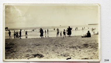
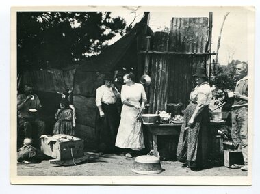 Orbost & District Historical Society
black and white photograph, C1916
This is a photograph of a railway camp, set up to house workers and their families when building the Bairnsdale to Orbost Railway in 1916. The Bairnsdale-Orbost railway was opened in 1916 to serve the agricultural and timber industry. Because of the decline in traffic and heavy operating costs, the line was finally closed in August, 1987. Orbost Railway Station was opened on Monday 10 April 1916 as the terminus of the Orbost railway line, and closed in 1987. The station was located on the west side of the Snowy River despite the town of Orbost being on the east side of the river, in order to save on the costs of a bridge over the river, which at the time had highly variable levels.This item is associated with the history of the Orbost-Bairnsdale railway line and therefore reflects the role that the rail line played in the social and economic history of Orbost.A black / white photograph of a campsite kitchen. The kitchen is outside against a roughly constructed hut. There are three women preparing food. Two men are drinking from tin mugs. a small child is crawling on the ground and another is seated.on back - "Railway Camp"orbost-railway newmerella-railway-camp transport -
 Eltham District Historical Society Inc
Photograph - Aerial Photograph, Landata, Eltham / Research, Vic, Jan. 1951
Centred on Brinkkotter Road opposite Yarramie Reserve, Eltham bounded by Maroondah Aqueduct to north, Nyora Road to south, Eltham College to east and Leane Drive to west. Historic Aerial Imagery Source: Landata.vic.gov.au Aerial Photo Details: Project No :65 Project : MELBOURNE AND METROPOLITAN PROJECT NO. 2 Run : 7 Frame : 8 Date : 01/1951 Film Type : B/W Camera : EAG9 Flying Height : 12200 Scale : 12000 Film Number : 1419 GDA2020 : 37°42'32"S, 145°10'41"E MGA2020 : 339408, 5824924 (55) Melways : 22 F3 (ed. 42)Historical aerial photos and photo maps provide viusal evidence of the chronology of changes to the built landscape of the district and assist in dating other imagesaerial photo, 1951-01, eltham, neil webster collection, brinkkotter road, eltham college, leane drive, maroondah aqueduct, melways 22f3, nyora road, yarramie reserve -
 Eltham District Historical Society Inc
Photograph - Aerial Photograph, Landata, Eltham, Vic, Jan. 1951
Centred on Beard Street between Main Road and Frank Street, Eltham bounded by Maroondah Aqueduct to north, Arthur Street to south, Maroong Drive to east and Catholic Ladies College to west. Historic Aerial Imagery Source: Landata.vic.gov.au Aerial Photo Details: Project No :65 Project : MELBOURNE AND METROPOLITAN PROJECT NO. 2 Run : 7 Frame : 9 Date : 01/1951 Film Type : B/W Camera : EAG9 Flying Height : 12200 Scale : 12000 Film Number : 1419 GDA2020 : 37°42'23"S, 145°09'39"E MGA2020 : 337874, 5825170 (55) Melways : 22 B3 (ed. 42)Historical aerial photos and photo maps provide viusal evidence of the chronology of changes to the built landscape of the district and assist in dating other imagesaerial photo, 1951-01, eltham, neil webster collection, arthur street, beard street, catholic ladies college, frank street, main road, maroondah aqueduct, maroong drive, melway 22b3, research (vic.) -
 Eltham District Historical Society Inc
Photograph - Aerial Photograph, Landata, Eltham North, Feb. 1956
Centred on present day 54 Kelway Crescent, Eltham North bounded by Glen Gully Road to north, Meruka Drive to south, Eltham College to east and Leach Street to west. Historic Aerial Imagery Source: Landata.vic.gov.au Aerial Photo Details: Project No :250 Project : MELBOURNE OUTER SUBURBS PROJECT Run : 17 Frame : 113 Date : 02/1956 Film Type : B/W Camera : EAG9 Flying Height : 10000 Scale : 12000 Film Number : 1176 GDA2020 : 37°42'16"S, 145°08'08"E MGA2020 : 335650, 5825336 (55) Melways : 21 G2 (ed. 42)aerial photo, 1956-02, eltham, eltham north, glen gully road, leach street, main road, melway 21g2, meruka drive, montmorency, neil webster collection -
 Eltham District Historical Society Inc
Photograph - Aerial Photograph, Landata, Montmorency, Feb. 1956
Centred on present day Tahlee Place Reserve and Sherbourne Preschool, Montmorency bounded by Progress Road to north, Withers Way to south, Main Road to east and Leach Street to west. Historic Aerial Imagery Source: Landata.vic.gov.au Aerial Photo Details: Project No :250 Project : MELBOURNE OUTER SUBURBS PROJECT Run : 17 Frame : 114 Date : 02/1956 Film Type : B/W Camera : EAG9 Flying Height : 10000 Scale : 12000 Film Number : 1176 GDA2020 : 37°42'50"S, 145°08'02"E MGA2020 : 335512, 5824286 (55) Melways : 21 F5 (ed. 42)aerial photo, 1956-02, neil webster collection, central park, eltham, leach street, main road, melway 21f5, montmorency, progress road, withers way, sherbourne preschool, tahlee place reserve