Showing 790 items
matching commercial house
-
 Kew Historical Society Inc
Plan, Melbourne and Metropolitan Board of Works, Borough of Kew : Detail Plan No.1580, 1904
The Melbourne and Metropolitan Board of Works (MMBW) plans were produced from the 1890s to the 1950s. They were crucial to the design and development of Melbourne's sewerage and drainage system. The plans, at a scale of 40 feet to 1 inch (1:480), provide a detailed historical record of Melbourne streetscapes and environmental features. Each plan covers one or two street blocks (roughly six streets), showing details of buildings, including garden layouts and ownership boundaries, and features such as laneways, drains, bridges, parks, municipal boundaries and other prominent landmarks as they existed at the time each plan was produced. (Source: State Library of Victoria)This plan forms part of a large group of MMBW plans and maps that was donated to the Society by the Mr Poulter, City Engineer of the City of Kew in 1989. Within this collection, thirty-five hand-coloured plans, backed with linen, are of statewide significance as they include annotations that provide details of construction materials used in buildings in the first decade of the 20th century as well as additional information about land ownership and usage. The copies in the Public Record Office Victoria and the State Library of Victoria are monochrome versions which do not denote building materials so that the maps in this collection are invaluable and unique tools for researchers and heritage consultants. A number of the plans are not held in the collection of the State Library of Victoria so they have the additional attribute of rarity.Original survey plan, issued by the MMBW to a contractor with responsibility for constructing sewers in the area identified on the plan within the Borough of Kew. The plan was at some stage hand-coloured, possibly by the contractor, but more likely by officers working in the Engineering Department of the Borough and later Town, then City of Kew. The hand-coloured sections of buildings on the plan were used to denote masonry or brick constructions (pink), weatherboard constructions (yellow), and public buildings (grey). The area represented in this detail plan has undergone significant change during the 20th century. The widening of High Street in the 1930s and 1950s involved the shops on the south side of High Street being demolished and later rebuilt to fit the widened street. Another significant loss was the mansion ‘Drayton’ fronting Wellington Street, owned at this stage by Susannah Fenton. Her family name would later to be given to Fenton Way, which was to be built over the grounds of the house following its demolition. The plan of the garden is particularly interesting, containing a batten dome fronting Wellington Street, an ornamental pond, a fountain and a brick and glass conservatory. The notes by the plumbing contractor on this plan are particularly detailed. Pink borders delineate the ownership of the varying parcels of land. Some of the better known owners listed include the real estate agent Cr. Henry de Castres Kellett (bt) and John Padbury, the funeral director. This particular plan provides a clear view of the configuration of the Kew Junction in 1903 and the commercial buildings that surrounded it.melbourne and metropolitan board of works, detail plans, maps - borough of kew, mmbw 1580, cartography -
 Kew Historical Society Inc
Photograph - Cosy Five Roomed Rough Cast Bungalow, Kew, J E Barnes, c.1920
Subdivision plans are historically important documents used as evidence of the growth of suburbs in Australia. They frequently provide information about when the land was sold on which a built structure was subsequently constructed as well as evidence relating to surveyors and real estate and financial agents. The numerous subdivision plans in the Kew Historical Society's collection represent working documents, ranging from the initial sketches made in planning a subdivision to printed plans on which auctioneers or agents listed the prices for which individual lots were sold. In a number of cases, the reverse of a subdivision plan in the collection includes a photograph of a house that was also for sale by the agent. These photographs provide significant heritage information relating house design and decoration, fencing and household gardens. The photograph is also aesthetically significant as it was taken by J. E. Barnes, a nationally significant photographer. He was the most important photographer to have worked in Kew. He was active as a photographer in the district from c.1906 until his death in 1921. Best known as 'the Embarkation Photographer' (see the Australian War Memorial collection), Josiah Earl Barnes was also the official photographer employed by the Borough (and later Town, then City) of Kew. He clearly also completed commercial jobs for local businesses, as is the case in this photograph of a house for a local real estate and financial agent. A modest weatherboard house with rough-cast rendered walls. The gabled entrance incorporates elements of the Japanese aesthetic. The strong lines of the dark timber gable are reinforced by the colour and shape of the pickets in the fence. In contrast to an earlier period, the chimneys appear truncated. The use of extensive double-hung sash windows in the front rooms reflects a new interest in light in houses. The use of separate sunshades over windows in an earlier period is here replaced by an extension of the roofline over the window. The photographer Josiah Barnes died in 1921; so, the photograph of the house must predate this date. The location of the house, which was advertised for sale, has to date not been identified. Illegible inscription. Photographer's information on mount.josiah earl barnes, j e barnes, photography - kew, interwar housing - victoria, 1920s housing - kew -
 Kew Historical Society Inc
Photograph - 8 roomed DF Brick Villa, Kew, J E Barnes, c.1920
Subdivision plans are historically important documents used as evidence of the growth of suburbs in Australia. They frequently provide information about when the land was sold on which a built structure was subsequently constructed as well as evidence relating to surveyors and real estate and financial agents. The numerous subdivision plans in the Kew Historical Society's collection represent working documents, ranging from the initial sketches made in planning a subdivision to printed plans on which auctioneers or agents listed the prices for which individual lots were sold. In a number of cases, the reverse of a subdivision plan in the collection includes a photograph of a house that was also for sale by the agent. These photographs provide significant heritage information relating house design and decoration, fencing and household gardens. The photograph is of additional aesthetic significance as it was photographed by J. E. Barnes. Josiah Earl Barnes is a nationally significant photographer. He was also the most important photographer to have worked in Kew. He was active as a photographer in the district from c.1906 until his death in 1921. Best known as 'the Embarkation Photographer' (see the Australian War Memorial collection), J. Earl Barnes was also the official photographer employed by the Borough (and later Town, then City) of Kew. He clearly also completed commercial jobs for local businesses, as is the case in this photograph of a house for a local real estate and financial agent.A photograph, mounted on board of a double fronted Federation-era brick villa in Kew, photographed for a local real estate agent and financier by J. E. Barnes of Kew. On the reverse of the photograph is a subdivision plan for the Normanby Estate, East Kew - 2016.0039.1. As can be seen from the image, there is a large tear on the surface of the photograph.The brown card on which the photograph is mounted includes the following handwritten description, which may aid the identification of the house: "Kew, 3 minutes from tram, 8 roomed DF Brick Villa, tile roof including two attics, sleepout, bathroom, heater, E Light, Entrance Hall, double doors, leadlights, laundry, garden, lawns, land 75 x 170, 1975 pounds". Also photographers inscription on mount, lower left: J. E. Barnes / Photo / Phone 1966 Haw. KEW.j. e. barnes, josiah earl barnes, j. earl banes - photographer, architecture - federation style, houses - kew, real estate photographs -
 Kew Historical Society Inc
Plan - Subdivision : Cotham and Glenferrie Roads, J R Mathers & McMillan
The Kew Historical Society's map collection includes a substantial number of real estate subdivision plans, mainly of Kew but also of surrounding suburbs in Melbourne. Most of the subdivision plans date from the 1920s and 1930s when the districts old homes and local farmland were being split up to accommodate residential growth in the postwar period. These early plans were assembled by a local firm, Jas R Mather & McMillan, which had an office in Cotham Road. Many of the plans, and sometimes photos, were annotated by the agents.Subdivision plans are historically important documents used as evidence for the growth of suburbs in Australia. They frequently provide information about when the land was sold as well as evidence relating to surveyors and real estate and financial agents. The numerous subdivision plans in the Kew Historical Society's collection represent working documents, ranging from the initial sketches made in planning a subdivision to printed plans on which auctioneers or agents listed the prices for which individual lots were sold. In a number of cases, the reverse of a subdivision plan in the collection includes a photograph of a house that was also for sale by the agent. These photographs provide significant heritage information relating house design and decoration, fencing and household gardens.The photograph may also be aesthetically significant depending on the importance of the photographic atelier.An undated and untitled hand-drawn and coloured subdivision plan detailing the boundaries of a number of irregular allotments bordering Cotham Road, Glenferrie Road and Stirling Avenue (now Stirling Street). The plan predates the actual subdivision that led to the creation of the eight commercial properties occupying 118-132 Cotham Road. The plan may represent an old subdivision that was further subdivided at a later date, or it may be a subdivision that never eventuated. On MMBW Detail Plan 1575 (1903), the area represented by the proposed subdivision was residential rather than commercial. The irregularity of lots is also apparent in the MMBW Plan. The largest of the unnumbered blocks on the hand-drawn subdivision plan may relate to the boundaries of the nineteenth century mansion identified as ‘Kelso’ on the MMBW Plan.subdivision plans - kew, cotham road - kew,, glenferrie road - kew , stirling avenue street - kew -
 Kew Historical Society Inc
Journal, Kewriosity : March 1992
... courses at Kew Community House / p13. Kew Junction Commercial ...Kew Festival Special Edition [16pp] / p1. Looking for deregulation in North America / Janet Dore p2&3. Mayor's Comment / Cr Daryl Oldaker p3. New Parking signs / p4. Disabled parking permits / p5. Long term parking p5. Girl Guides & Brownie Guides of Kew / p5. Anyone for tennis? [East Kew Uniting Church] / p5. Football in Kew / p5. New Principal at Hew High School [Alan Taylor] / p6. Trinity Grammar Open Day / p6. Youth Leadership Course / p7. Caritas Christi Hospice Awareness Week / p7. Kew Youth Arts Festival [programme of events] / pp8-9. Diary Dates for March [1992] / p10. Kew Festival Concert at Holy Trinity / p10. Direct Line 2 [Kew Cottages] / p11. Kew Recreation Centre 383-407 High Street, Kew / p11. Healthy fun activities / p11. Free bike identification / p12. Feet feature / p12. New courses at Kew Community House / p13. Kew Junction Commercial Centre / p14. Fundraisers extraordinaire [St. George’s Hospital Kew Ladies’ Auxiliary] / p14. Vale - John Hogan Gervasoni J.P. 1929-1992 / p15. Draft Gaming Machine Policy / p15. Revealing Villa Alba - Open Days / p16.Kewriosity was a local newsletter combining Kew Council and community news. It was published between November 1983 and June 1994, replacing an earlier Kewriosity [broad] Sheet (1979-84). In producing Kewriosity, Council aimed to provide a range of interesting and informative articles covering its deliberations and decision making, together with items of general interest and importance to the Kew community and information not generally available through daily media outlets.non-fictionKew Festival Special Edition [16pp] / p1. Looking for deregulation in North America / Janet Dore p2&3. Mayor's Comment / Cr Daryl Oldaker p3. New Parking signs / p4. Disabled parking permits / p5. Long term parking p5. Girl Guides & Brownie Guides of Kew / p5. Anyone for tennis? [East Kew Uniting Church] / p5. Football in Kew / p5. New Principal at Hew High School [Alan Taylor] / p6. Trinity Grammar Open Day / p6. Youth Leadership Course / p7. Caritas Christi Hospice Awareness Week / p7. Kew Youth Arts Festival [programme of events] / pp8-9. Diary Dates for March [1992] / p10. Kew Festival Concert at Holy Trinity / p10. Direct Line 2 [Kew Cottages] / p11. Kew Recreation Centre 383-407 High Street, Kew / p11. Healthy fun activities / p11. Free bike identification / p12. Feet feature / p12. New courses at Kew Community House / p13. Kew Junction Commercial Centre / p14. Fundraisers extraordinaire [St. George’s Hospital Kew Ladies’ Auxiliary] / p14. Vale - John Hogan Gervasoni J.P. 1929-1992 / p15. Draft Gaming Machine Policy / p15. Revealing Villa Alba - Open Days / p16.publications -- city of kew (vic.), kewriosity, council newsletters, community newsletters -
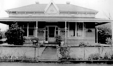
![Victorian era cottage, Derby Street [Kew]](/media/collectors/550653872162f11fb04854aa/items/658f5772101c4283c6ae47ff/item-media/658f57e4101c4283c6ae493a/item-fit-380x285.jpg) Kew Historical Society Inc
Kew Historical Society IncPhotograph - Victorian era cottage, Derby Street [Kew], c. 1965
The current site of the Kew Recreation Centre in High Street Kew previously housed the Kew Depot on the corner of Disraeli Street. In nearby Derby Street, a number of original Victorian era buildings were gradually replaced due to development of the Baths precinct and commercial development.This work forms part of the collection assembled by the historian Dorothy Rogers (1905-1973), donated to the Kew Historical Society by her son in 2015. The manuscripts, photographs, maps, and documents were sourced by her from both family and local collections or produced as references for her print publications. Many were directly used by Rogers in writing ‘Lovely Old Homes of Kew’ (1961) and 'A History of Kew' (1973), or the numerous articles on local history that she produced for suburban newspapers. Most of the photographs in the collection include detailed annotations in her hand. The Rogers Collection provides a comprehensive insight into the working habits of a historian from the 1960s to the 1970s. Small single fronted cottage in Derby Street, Kew. The weatherboard cottage has a block fronted facade, and a Victorian verandah with cast iron lace.Annotation verso: "House in Derby St., next to Kew Baths (Demolished?)"dorothy rogers, derby street (kew), victorian houses -- kew (vic.) -
![Victorian era cottage, Derby Street [Kew]](/media/collectors/550653872162f11fb04854aa/items/658f7ef19239cf6fd436d1fd/item-media/658f7f019239cf6fd436d25f/item-fit-380x285.jpg) Kew Historical Society Inc
Kew Historical Society IncPhotograph - Victorian era cottage, Derby Street [Kew], c. 1965
The current site of the Kew Recreation Centre in High Street Kew previously housed the Kew Depot on the corner of Disraeli Street. In nearby Derby Street, a number of original Victorian era buildings were gradually replaced due to development of the Baths precinct and commercial development.This work forms part of the collection assembled by the historian Dorothy Rogers (1905-1973), donated to the Kew Historical Society by her son in 2015. The manuscripts, photographs, maps, and documents were sourced by her from both family and local collections or produced as references for her print publications. Many were directly used by Rogers in writing ‘Lovely Old Homes of Kew’ (1961) and 'A History of Kew' (1973), or the numerous articles on local history that she produced for suburban newspapers. Most of the photographs in the collection include detailed annotations in her hand. The Rogers Collection provides a comprehensive insight into the working habits of a historian from the 1960s to the 1970s. Small single fronted cottage in Derby Street, Kew. The weatherboard cottage has a block fronted facade, and a Victorian verandah with cast iron lace.dorothy rogers, derby street (kew), victorian houses -- kew (vic.) -
 Kew Historical Society Inc
Plan - Subdivision Plan, Shop Sites, East Kew, c.1927
Subdivision plans are historically important documents used as evidence of the growth of suburbs in Australia. They frequently provide information about when the land was sold on which a built structure was subsequently constructed as well as evidence relating to surveyors and real estate and financial agents. The numerous subdivision plans in the Kew Historical Society's collection represent working documents, ranging from the initial sketches made in planning a subdivision to printed plans on which auctioneers or agents listed the prices for which individual lots were sold. In a number of cases, the reverse of a subdivision plan in the collection includes a photograph of a house that was also for sale by the agent. These photographs provide significant heritage information relating house design and decoration, fencing and household gardens.This is one of a small number of subdivision plans for commercial property in the collection. The subdivision proposed to create six shop sites in High Street between the Harp of Erin and Station Street. The plan shows this stretch of High Street, East Kew already lined with shops that include the hotel on the corner, the new State Savings Bank, a dentist’s surgery and Lambert’s Store. The High Street Tram was to reach Burke Road in 1925, so the proposed subdivision must postdate that event, and the opening of the Bank in 1926.subdivision plans - east kew, high street - east kew -
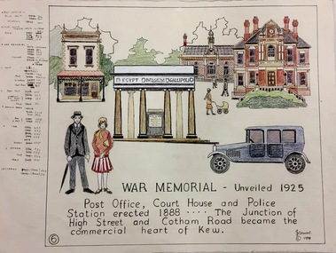 Kew Historical Society Inc
Work on paper, Joy Stewart, 6. War Memorial: Unveiled 1925, 1988
Kew Tapestry The eight panels depict the history of Kew. This was a 1988 Australian Bi-Centennial Project carried out under the auspices of City of Kew Council and the Kew Historical Society Incorporated. Nearly 600 citizens including many children participated in the production by adding a few or more stitches. A book records their names and the panels upon which they worked. Artist: Joy Stewart Co-ordinator: Dorothy BenyeiSydney Joy (Joy) Stewart was born in Melbourne 1925. She studied at Swinburne Technical College Art School from 1941-1945, then the National Gallery Art School 1946-1948. Her career included employment positions as a display artist, designer/painter, gallery assistant, and art teacher. Joy relocated to Cairns in 1981. Solo exhibitions in Melbourne and Cairns, including 'Done By Me' at Cairns Regional Gallery in 1999. Group exhibitions at Cairns Regional Gallery, 'The Fish John West Regrets, 1993' and 'Facets of Life' 1994. Joy Stewart died in Cairns in 2018.6. War Memorial: Unveiled 1925. A Handcoloured cartoon created by the artist Joy Stewart as a template for the sixth of a series of embroidered panels depicting the history of Kew. Wool colour codes at left. Inscription: "WAR MEMORIAL: Unveiled 1925. Post Office, Court House and Police Station erected 1888. ... The Junction of High Street and Cotham Road became the commercial heart of Kew." Signed by the artist "(c) JStewart, 1988"bicentennial project (kew), joy stewart, wwi, kew war memorial -
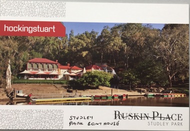 Kew Historical Society Inc
Postcard, Ruskin Place, Studley Park, c.2010
The Kew Historical Society's postcard collection includes views of Kew, Melbourne and Greater Melbourne as well as those including overseas scenes sent or received from Europe or the Middle East. They date from the 1890s to the 2000s.Commercial postcard produced by Hocking Stuart to advertise Ruskin Place, 75 Princess Street, Kew, but instead showing the Studley Park Boat House.The reverse includes advertising copy relating to the company and to Ruskin Place, 75 Princess Street, Kew.ruskin place - kew, 75 princess street - kew, studley park boat house -
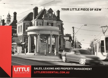 Kew Historical Society Inc
Postcard, Little Residential, Your Little Piece of Kew, c.2013
The Kew Historical Society's postcard collection includes views of Kew, Melbourne and Greater Melbourne as well as those including overseas scenes sent or received from Europe or the Middle East. They date from the 1890s to the 2000s. These postcards may or may not include the name of the publisher or printer. A number of the cards were published as parts of popular series. A way of dating early postcards is to identify whether the reverse was divided by a central line which became the norm after 1902 in the United Kingdom. However, other postcards produced after this date do not always conform to this print layout.Commercial postcard produced by Little Residential showing the Kew War Memorial, the QPO Restaurant and the former Kew Court House.The reverse includes details about the company and its services (see image)postcards, qpo restaurant, kew post office, kew war memorial -
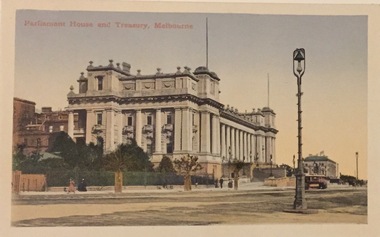 Kew Historical Society Inc
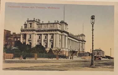
Postcard, Parliament House and Treasury, Melbourne, c.1907
Collection of thirty-nine postcards donated by Jillian Rigby which had been owned by her grandparents, George and Edith Weir, who from c.1917 lived at 84 Princess Street, Kew. The mostly 'mint' postcards were purchased in Victoria and while travelling overseas. The sole dated postcard is dated from 1929. The postcards are numbered sequentially from 2017.0058.01-39. The remainder of the collection donated by Jill Rigby which was once owned by the Weirs of Broken Hill and Kew consist of costumes, costume accessories, photographs, and documents.The postcards in the Weir collection, especially those purchased on a trip or trips to the mother country, i.e. United Kingdom, represent a representative sample of sites that were considered significant to those Australians undertaking a reverse grand tour by member of the erstwhile colonies. Those postcards which are early views of Melbourne must have been produced commercially for some decades from the early part of the 20th century.Parliament House and Treasury, Spring Street, Melbourne. Coloured postcard of early Melbourne. Weir collection."Parliament House and Treasury, Melbourne"postcards, george and edith weir, parliament house - melbourne, treasury building - melbourne, weir collection -
 Kew Historical Society Inc
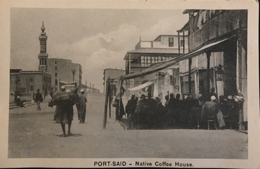
Postcard, The Cairo Postcard Trust, Port Said - Native Coffee House, c.1918
One of a number of 'real photo' and commercial postcards created by or owned by members of the Christian and Washfold families of Kew. The postcards are part of a larger collection of photographs, postcards and publications donated to the collection in May 2021.Sepia postcard of Port Said, located on the north east coast of Egypt on the Mediterranean Sea, showing mosque and minaret at left and coffee house in foreground at right.The Caro Postcard Trust Cairo 959 / Serie 632washfold family, christian family, postcards -- port said, christian-washfold collection -
 Kew Historical Society Inc
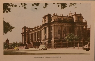
Postcard, Nucolorview Productions, Parliament House, Melbourne, 1920-1935
One of a number of 'real photo' and commercial postcards created by or owned by members of the Christian and Washfold families of Kew. The postcards are part of a larger collection of photographs, postcards and publications donated to the collection in May 2021.Colour postcard of Parliament House, Melbourneparliament house -- melbourne, postcards -- melbourne (vic.), christian-washfold collection -
 Kew Historical Society Inc
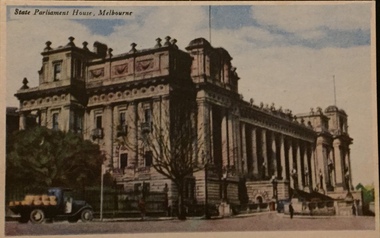
Postcard, Novelty Card Co, State Parliament House, Melbourne
One of a number of 'real photo' and commercial postcards created by or owned by members of the Christian and Washfold families of Kew. The postcards are part of a larger collection of photographs, postcards and publications donated to the collection in May 2021.Coloured matte postcard with oblique view of Parliament House looking south."Melbourne Vistas" Seriesparliament house -- melbourne, postcards -- melbourne, christian-washfold collection -
 Kew Historical Society Inc
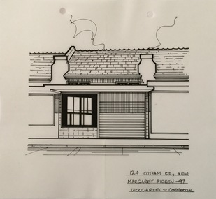
Drawing - Property Illustration, Margaret Picken, 124 Cotham Road, Kew, 1997
After training as a Cartographic Draftsman within the mining industry, I worked as a property illustrator for real estate firms in the eastern suburbs of Melbourne for 23 years from 1983. I initially photographed houses with a Polaroid camera and made a 'thumbnail' sketch while there. The photos were used to scale off a sketch in pencil and then that sketch was overlaid with drafting film and the 'pen and ink' completed. The pens I used were the Rotring ‘Rapidigraph’ drafting pens. The ink was also made by Rotring (German).The film was ‘Rapidraw’, polyester drafting film, double matte. It takes a very fine line and doesn’t bleed. As well as house sketches, there were often floor plans and site plans ordered. Aerial sketches were ordered when the property needed an overall view. (Margaret Picken, 2020)This drawing is one of a series created by Margaret Picken for a range of real estate agents in Melbourne between c.1983 and c.2005. Each work is signed and dated by the artist.Gift of Margaret Picken, 2020Pen and ink architectural drawing on drafting film of 124 Cotham Road, Kew by Margaret Picken.124 COTHAM RD., KEW / MARGARET PICKEN ~97 / WOODARDS ~ COMMERCIALartist -- margaret picken 1950-, architectural drawings -- houses -- kew (vic.), 124 cotham road -- kew (vic.) -
 Sunbury Family History and Heritage Society Inc.
Photograph, Former medical centre, 2001
The house was one of Sunbury's older houses and was on the corner of Horne and Neill Streets. Before it was demolished for larger commercial development, the property was a medical centre and later an employment and training office. A coloured photograph of a weatherboard house with a corrugated iron roof with its street number clearly attached to the front of the house.horne street, neill street -
 Sunbury Family History and Heritage Society Inc.
Photograph, 15th August 1995
The house was the former station master's residence. When the photograph was taken it served as a restaurant. In the late 1990s it was demolished to make way for larger commercial development.The former stationmaster's residence was one of the important buildings in Sunbury.A coloured photograph of a cream weatherboard house with light green trims surrounded by a garden. Four cars are parked outside the house.sunbury railway station, stationmaster's residence, brook street -
 Sunbury Family History and Heritage Society Inc.
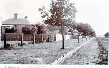
Photograph - Evans Street, Sunbury, c1900s
The photograph shows a picture of Evans Street Sunbury taken from the T intersection at Macedon Street and looking south. When the photograph was taken it was one of Sunbury's main residential areas. Since the 1980s the houses in the image have been demolished and replaced with commercial development. Over the years Evans Street has undergone much change from being a residential strip to being the main commercial hub in Sunbury.A sepia photograph with a white border across the bottom and in post card format of a streetscape with a row of trees growing along the footpath and a number of weatherboard Victorian style double fronted cottages. Both the roadway and footpath are not surfaced and the gutter is lined with stone pavers.EVANS STREETevans street -
 Stawell Historical Society Inc
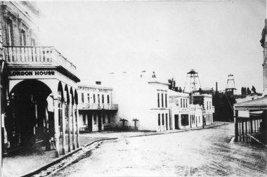
Photograph, Upper Main Stawell Street looking East with London House on the left 1880
... / Liddiard's / London House on left. Commercial Hotel, Oriental Bank... east. London House on left, Commercial Hotel near centre... / Liddiard's / London House on left. Commercial Hotel, Oriental Bank ...Upper Main Street looking East. c 1880. Chadwick's Draper / Liddiard's / London House on left. Commercial Hotel, Oriental Bank / Bank of Australia, Punchard Furniture, Earlier Union Bank. Extended Cross Reef and Sloane and Scotchmans poppet Heads in Background.Street scene of north side of upper Main Street looking east. London House on left, Commercial Hotel near centre of image. Two poppet heads of mines at right distance.stawell streetscape -
 Surrey Hills Historical Society Collection
Photograph, 2-4 Kent Road, Surrey Hills, 1987
'Rangitera' - 4 Kent Road - this house has been demolished. It was the address of Campbell Craven Dobbie c1909. He is variously listed as a commercial traveller / printer in electoral rolls. In 1906 he lived in Barton Street and from 1921-1914 is listed at 'Rangatea', Union Road, Balwyn. He served in WW1 in the 8th battalion as a captain; enlisted 4 September 1914 and returned 9 September 1916. Had a son Pat (REF: Trove Obituary, Argus, 27 March 1945)A black and white photograph of a Edwardian style / Federation style house with a cyclone fence and gate at the front of the property.kent road, surrey hills, campbell dobbie (capt), campbell craven dobbie (capt), world war 1, house names, 'rangitera', 'rangatea' -
 Vision Australia
Administrative record - Text, Royal Victorian Institute for the Blind annual report 1966-1967, 1966-1967
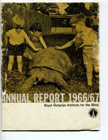
Articles in annual report include: Office bearers of the institute/officers, President's report - 100 years, Residence nursery and school for blind children - in 1866 first nine blind children were accommodated in temporary premises in Commercial Road Prahran, the budget was $822 pounds, now the facility in Burwood can house 70 children and the, budget is $160,000, New found confidence after rehabilitation, Blind welfare work increases, Our factory now serves industry, Employ opportunities are widening, Our loyal auxiliaries and other supporters, What of the future, Income and expenditure, Where there's a will there's a way to help blind people. Events that occurred in 1966 : Millet broom making was discontinued and mat and industrial brush making and packing and assembly began, the Governor of Victoria and Lady Delacombe brought their dog to visit the children at the school, the Institute began two vital new projects - providing a residential geriatric facility and to establish the RVIB foundation for research and education.1 volume of print and illustrationsannual reports, royal victorian institute for the blind -
 Vision Australia
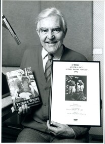
Photograph - Image, 1992 TDK Australian Audio Book Award narrator James Condon, 1992
To encourage the development of audio books, a series of awards were established by the National Library of Australia in 1988, and sponsored by TDK from 1991 until their demise in 2000. Open to both commercial and non-commercial publishers, it aimed to recognise the quality achievements by individuals and publishing houses and to promote the inclusion of audio books into the mainstream market. In 1992 the winner of the Adult Literature Category was "Patrick White: A Life" by Louis Braille Production and its narrator James Condon.2 black and white photographs, 1 proof sheet of transparencies and 8 transparencieslouis braille audio, awards, james condon -
Vision Australia
Text, 2000 Australian Audio Book Award, 2000
To encourage the development of audio books, a series of awards were established by the National Library of Australia in 1988, and sponsored by TDK from 1991 until their demise in 2000. Open to both commercial and non-commercial publishers, it aimed to recognise the quality achievements by individuals and publishing houses and to promote the inclusion of audio books into the mainstream market. In 2000 the winner of the Unabridged Fiction Category was "An Accommodating Spouse" by Louis Braille Audio.1 x A3 sheetImage of a fish illustration with the words 'Spits-beck, on le. Bec pointu du Mont rouge eft bon & commun. 84" between header and recipient louis braille audio -
Vision Australia
Text, 1995 TDK Australian Audio Book Award, 1995
To encourage the development of audio books, a series of awards were established by the National Library of Australia in 1988, and sponsored by TDK from 1991 until their demise in 2000. Open to both commercial and non-commercial publishers, it aimed to recognise the quality achievements by individuals and publishing houses and to promote the inclusion of audio books into the mainstream market. In 1995 the winner of the Unabridged Non-Fiction Category was "Goodbye Girlie" by Louis Braille Books.1 x A3 sheetImage of 3 Painted Parrots by William T Cooper between header and recipient louis braille audio -
Vision Australia
Text, 2000 Australian Audio Book Award, 2000
To encourage the development of audio books, a series of awards were established by the National Library of Australia in 1988, and sponsored by TDK from 1991 until their demise in 2000. Open to both commercial and non-commercial publishers, it aimed to recognise the quality achievements by individuals and publishing houses and to promote the inclusion of audio books into the mainstream market. In 2000 the Overall Winner was "My Girragundji" and "The Binna Binna Man" by Louis Braille Audio.1 x A3 sheetImage of a crab illustration with the words '168 Krabbe d'Arbre deffinee a Amboine. Ily a plus de ces cacres terrestres que de Soures: et elles font de figures fort de figures fort differentes; maiselles ne vallent rien" between header and recipient louis braille audio -
Vision Australia
Text, 1993 TDK Australian Audio Book Award, 1993
To encourage the development of audio books, a series of awards were established by the National Library of Australia in 1988, and sponsored by TDK from 1991 until their demise in 2000. Open to both commercial and non-commercial publishers, it aimed to recognise the quality achievements by individuals and publishing houses and to promote the inclusion of audio books into the mainstream market. In 1993 the winner of the Adult Literature Category was "The English Patient" by Louis Braille Books.1 x A3 sheetImage of 'The White Peacock' by Lionel Lindsay between header and recipient louis braille audio -
Vision Australia
Text, 2000 Australian Audio Book Award, 2000
To encourage the development of audio books, a series of awards were established by the National Library of Australia in 1988, and sponsored by TDK from 1991 until their demise in 2000. Open to both commercial and non-commercial publishers, it aimed to recognise the quality achievements by individuals and publishing houses and to promote the inclusion of audio books into the mainstream market. In 2000 the winner of the Author/Narrator Category was "My Girragundji" and "The Binna Binna Man" by Louis Braille Audio.1 x A3 sheetImage of a fish illustration with the words 'Mouffour Annak" between header and recipient louis braille audio -
Vision Australia
Text, 1996 TDK Australian Audio Book Award, 1996
To encourage the development of audio books, a series of awards were established by the National Library of Australia in 1988, and sponsored by TDK from 1991 until their demise in 2000. Open to both commercial and non-commercial publishers, it aimed to recognise the quality achievements by individuals and publishing houses and to promote the inclusion of audio books into the mainstream market. In 1996 the winner of the Unabridged Non-Fiction Category was "Home Before Dark" by Louis Braille Books.1 x A3 sheetIllustration of wattle by an unknown artist between header and recipient louis braille audio