Showing 10950 items matching " plan"
-
 Ringwood and District Historical Society
Pamphlet, Land Sale Brochure Titled Eureka Plan Book - Seven Delightful & Valuable Ringwood Estates - circa 1925
Twenty page land sale brochure including photographs, subdivision features and local facilities. Additional flyer with conditions of sale and prices for estate blocks.Seven delightful and valuable Ringwood Estates called Bestpart, Paradise, Hill Top, Greenwood, Creek, Station, and School Estates. These nestle amidst the hills and valleys of beautiful Ringwood district. Also Goodluck Estate at Clarinda. Pamphlet marked as being From Mr. Farmer, No. 5 Flinders Court, Melbourne. Phone 988, 989 Central, or 55 Ringwood after 7 p.m. Plan of Ringwood School Estate includes William Street (later Kendall Street), Greenwood Avenue, Alton Street and Locke Street. Plan of Bestpart Estate, Ringwood, includes Bedford Road, Wilana Street, Greenwood Avenue, Caroline Street, Henry Street and Haig Street. Plan of Ringwood Station Estate includes Pitt Street, Bedford Road, Greenwood Avenue, Station Street, William Street (later Kendall Street, James Street, Wantirna Road, Caroline Street, Henry Street, Ellison Street and Haig Street. Plan of Geenwood Estate, Ringwood, includes Prussian Road (later Geenwood Avenue). Plan of Paradise Estate, Ringwood, includes Canterbury Road, Dandenong Road (Wantirna Road), Luck Street and Paradise Road. Plan of Creek Estate, Ringwood, includes Dandenong Creek, Wantirna Road and Gordon Crescent. Plan of Hill Top Estate, Ringwood (later Heathmont area), includes Heathmont Railway Station, Heathmont Road, Balfour Avenue, Lilian Street, Edith Street, Edna Street and Great Ryrie Street. Plan of Goodluck Estate, Clarinda, includes Talbot Avenue, Good Street, Luck Street, and Centre Road in locality plan between Oakleigh and Clayton Railway Stations. -
 Bacchus Marsh & District Historical Society
Map, Plan of Land at Bacchus Marsh, the Property of James Young, 1868
James Young was a prominent businessman, land owner and public figure in the early colonial period of Bacchus Marsh. In February 1868 he offered for sale through the agent W. Anderson 38 blocks of land which ran from the Lerderderg RIver westwards beyond Gisborne Road in the vicinity of the present day Masons Land. The land for sale was described as, 'unsurpassed Agricultural Land, in the immediate vicinity of Bacchus Marsh, varying in size from 2 to 12 acres each'. The sale notice in the Bacchus Marsh Express of 1st February 1868 page 2, also noted that, ' Plans can be seen at Mr. Young's Border Mills Store, and at the Border Inn'. One of the largest and most important land sales in the early colonial period of Bacchus Marsh.A single page paper map showing 38 blocks of land for sale in 1868 in the vicinity of Masons Lane Bacchus Marsh. Scale 11 chains to 1 inch. The map is pasted into a bound volume containing 76 maps or plans in total. High resolution digital image stored on BMDHS computer network. land sales bacchus marsh, bacchus marsh victoria maps, james young 1816-1871, masons lane bacchus marsh land sales -
 Bacchus Marsh & District Historical Society
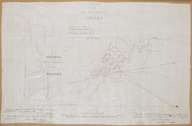
Map, Plan of the Village of Melton
A single page paper map showing a plan for the village of Melton, Parish of Djerriwarrh, County of Bourke. The map is pasted into a bound volume containing 76 maps or plans in total. High resolution digital image stored on BMDHS computer network. melton victoria maps -
 Falls Creek Historical Society
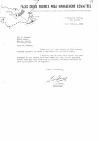
Letter - Approval To Erect New Chair Lift Referred To Master Plan Sub Committee
Bob (Herman) Hymans (a former member of the Royal Netherlands Navy) was born in Bloemendaal, Holland on 30th September 1922. During World War II he fought against the Japanese in the Dutch East Indies (now Indonesia) and was imprisoned in Changi and on the Burma Railway. After gaining qualifications as a Ski Instructor, Bob arrived in Falls Creek in July 1950. Working as an Instructor and Supervisor at Bogong Lodge, Bob decided his future was in accommodation. He was successful in negotiating an indenture for land from the State Electricity Commission (SEC). It took Bob two years to build his Grand Coeur Chalet but, tragically, it was burned down in August 1961. Bob also built the first Chairlift in Australia. This was a single chairlift and the structure was built from wooden electricity poles. He was constantly full of new ideas and proposals for the village. Bob Hymans died on 7th July 2007. This Collection of documents and letters tells the story of Bob's endeavours to develop Falls Creek into the ski village it is today.This letter is significant because it reflects the relationship between Bob Hymans and the Management Committee.A letter from the Management Committee acknowledging receipt of Mr Hymans application to construct a double chairlift. It advises that the letter has been referred to the Master Plan Sub Committee and that as the plan is still being finalised no early decision should be expected.falls creek tourist area management committee, chairlift licence negotiations, double chairlift -
 Ringwood and District Historical Society
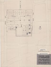
Plan, Myer Emporium Limited, Planning Application by Eastland Shopping Centre Pty Ltd - Ringwood Planning Scheme 1960. 2 Plans, 1960
One of the plans referred to in the application by Eastland Shopping Centre, a wholly owned subsidiary of the Myer Emporium Limited.|Upper floor plan and lower level traffic plan. Application No 3, Ringwood Planning Scheme 1960.|Architects: Tompkins, Shaw & Evans|Traffic Engineers: Len T Frazer and AssociatesTwo copies of plans for the Ringwood Shopping Centre, comprising; 1. Upper floor plan; 2. Lower level traffic level; Buff coloured heavy paper with black printing. Application No 3, Ringwood Planning Scheme. Shopping Centre at Ringwood design for developmetn submitted by EASTLAND SHOPPING CENTRE PTY.LTD a wholly owned subsidiary of THE MYER EMPORIUM LIMITED Architects: Tomkins, Shaw and Evans Taffic Engineers: Len T. Frazer & Assocs -
 Federation University Historical Collection
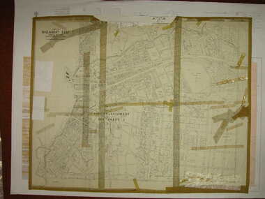
Plan, Ballarat East, 1916, 24/05/1916
Plan of streets and allotments in Ballarat East. Includes: Bakery Hill, Canadian Station, Eureka Cemetery, Orphan Asylum, Eureka Gardens and Reserve, Gun Clubballarat east, bakery hill, eureka stockade site, eureka gardens, ballarat orphanage -
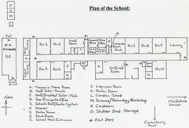 Ringwood and District Historical Society
Plan - Plans - Building, Southwood Primary School, Ringwood, Collection of building plans, site plans, floor plans 1969-1991
folder of papers plansSouthwood PS - Site Plan and floor plans including A.D. Alexander Hall. Permanent File. To be archived at P.R.O when no longer required. -
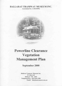 Ballarat Tramway Museum
Document - Report, City of Ballarat, "Powerline Clearance Vegetation Management Plan", Sep. 2000
Management Plan titled "Powerline Clearance Vegetation Management Plan", dated Sept. 2000, 48 pages, each page within an individual sheet, and contained within a clear plastic covers binder with a black spiral binding mechanism. Prepared by the City of Ballarat for the BTM. Indexed. Includes a plan of Wendouree Parade, showing the tram lines. pdf copy made by PPW 11/2010 and added to Management System.trams, tramways, overhead, wendouree parade, btm, city of ballarat -
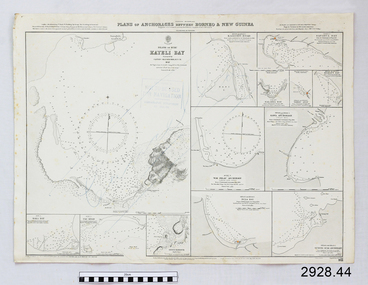 Flagstaff Hill Maritime Museum and Village
Document - Navigation Chart, Plan of Anchorages between Borneo and New Guinea
British Admiralty Navigation Chart - Plan of Anchorages between Borneo and New Guinea with Kayeli Baywarrnambool, shipwrecked-coast, flagstaff-hill, flagstaff-hill-maritime-museum, maritime-museum, shipwreck-coast, flagstaff-hill-maritime-village, shipwrecked-artefact, navigation chart, british admiralty navigation chart, british admiralty -
 Victorian Aboriginal Corporation for Languages
Book, Department of Education and Early Childhood Development, Languages : expanding your world : plan to implement the Victorian Government's vision for languages education 2013-2025, 2013
A long term government plan to increase diversity of language learning and proficiency across Victorian schools.colour photographs, colour illustrations, tableslanguage and education, bilingualism, language revival, government school education, program certification, certificate of language proficiency, education policy -
 Whitehorse Historical Society Inc.
Article, Developer proffers new plan, 2005
Compromise plans for multi-storey apartment towers in Colombo Street Mitcham, rejected by Whitehorse CouncilCompromise plans for multi-storey apartment towers in Colombo Street Mitcham, rejected by Whitehorse CouncilCompromise plans for multi-storey apartment towers in Colombo Street Mitcham, rejected by Whitehorse Councilhigh-rise buildings, colombo street, mitcham, planning development -
Whitehorse Historical Society Inc.
Document, Sale Plan 38, 12/09/1855
Parish of Nunawading Sale Plan 38.Parish of Nunawading Sale Plan 38. Description of land is given with water supply. Surveyor C.Hodgkinson.Parish of Nunawading Sale Plan 38. parish of nunawading, hodgkinson, clement, water supply -
Whitehorse Historical Society Inc.
Document, Stephens Reserve Management Plan, 1/02/1994
City of Nunawading, Parks and Recreation Services : Stephens Reserve Management Plan, February 1994 (Draft)parks and reserves, stephens reserve -
Lakes Entrance Historical Society
Book, Smith, Ian; Byrne, Gerry; Hanson, Frank, North Arm Foreshore and Estuary Action Plan, 1996
Report of the Action Plan for the future management of the North Arm and its environs, Lakes Entrance, Victoriawaterways, conservation -
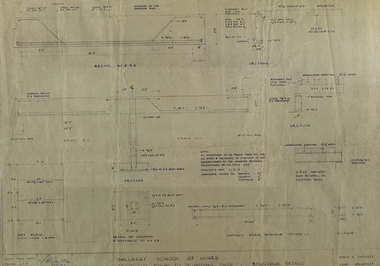 Federation University Historical Collection
Plan, Ballarat School of Mines Additional Rooms to Plumbing Shop, by Chief architect Percy E. Everett, 1945, 14/01/1945
.1) Copy of structural details for additional rooms for the Ballarat School of Mines Plumbing Building, 1945 .2) Copy of structural details for additional rooms for the Ballarat School of Mines Plumbing Building, 1945 .3) Copy of an engineering plan for additional rooms for the Ballarat School of Mines Plumbing Building, 1948 .4) Copy of a plan for additional rooms for the Ballarat School of Mines Plumbing Building, 1945ballarat school of mines, plumbing, architectural plan -
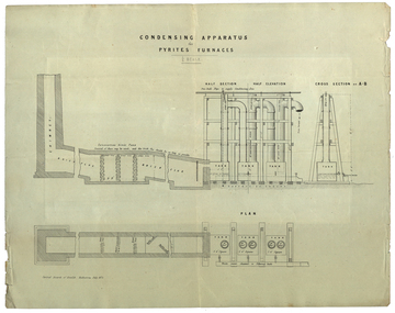 Federation University Historical Collection
Plan, Central Board of Health, Condensing Apparatus for Pyrites Furnaces, 07/1873
Possibly linked in some way to Patent for the Ballarat School of Mines self-acting Pyrites Furnace.Printed plan for a condensing Apparatus for Pyrites Furnacespyrites, pyrities, pyrites furnace, condensing apparatus -
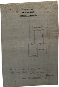 Federation University Historical Collection
Plan, Tracing of M.T. No 213 Hard HIlls, 1870, 01/11/1870
Scale: 8 chains to 1 inch (1:6336)Hand drawn plan on waxed white linen."This is a correct copy from my Registration Book. [Rob N. Horay?] Mining registrar 1/11/70hard hills, survey -
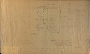 Federation University Historical Collection
Plan, Proposed Workshops for Smithing-Oxy-Welding & Electrical Welding
Plan of building along Albert Street, Ballarat.ballarat school of mines, akbert street, blacksmithing, electric welding, oxy-welding -
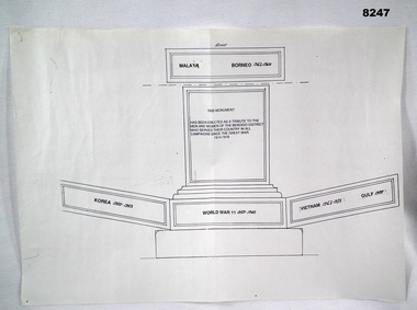 Bendigo Military Museum
Plan - MONUMENT PLAN, C.1992
This plan refers to a proposed erection of a Monument to be erected in the front of the Soldiers Memorial Institute in Pall Mall Bendigo. Refer Cat No 8245.2Plan, white paper, black ink showing a monument with the sides laid out to show prospective inscriptions on.brsl, smirsl, monument, plan -
Federation University Historical Collection
Plan, Ballarat School of Mines Amenity Centre, 1979, 06/1979
A 'birds-eye' (axonometric) of the proposed Ballarat School of Mines Student Centre, later named the Amenities Building.ballarat school of mines, amenities building, buildings, student amenity centre, ewan jones and associates, architects, vic mckay, plan -
NMIT (Northern Melbourne Institute of TAFE)
Schematic plan of Redevelopment of Preston Campus, NMIT, 2012
Four piece Schematic plan of Redevelopment of Preston Campus of NMIT 2012, together with models of buildings and trees. nmit, preston campus redevelopment 2012, schematic plan. -
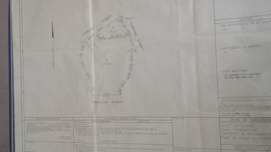 Peterborough History Group
Map - survey of Hamilton St wetland, Plan of Subdivision Hamilton Street
Subdivided to preserve the wetland, locals estimate it occurred between 1976 and 1983A3 plan of subdivision showing the outline of the swamp bounded by Hamilton St, Charles St and Cumming St. peterborough, survey map, golden pond -
Whitehorse Historical Society Inc.
Document, Plan of lot in Grey Street, Mitcham, 1933
Copy of Shire of Blackburn and Mitcham plan re Lot 19 in Grey Street, Mitcham [now Vermont].Copy of Shire of Blackburn and Mitcham plan re Lot 19 in Grey Street, Mitcham [now Vermont].Copy of Shire of Blackburn and Mitcham plan re Lot 19 in Grey Street, Mitcham [now Vermont].shire of blackburn and mitcham, grey street, vermont, lot 19, mitcham road, vermont -
Whitehorse Historical Society Inc.
Document, Bicycle Plan, 1/06/1991
Strategic Bicycle Plan prepared by Environmental Engineering Department Operations Group, City of Nunawading, June 1991city of nunawading environmental engineering department - operations group, abbott, kevin -
 Whitehorse Historical Society Inc.
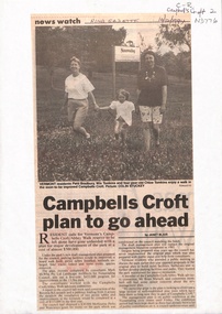
Newspaper - Article, Campbells Croft plan to go ahead, 14/12/1994
'Campbells Croft plan to go ahead' by Janet Blair. Article in Nunawading Gazette, 14 December 1994.parks and reserves, campbells croft, bradbury, patti, tomkins, win, chloe -
 Whitehorse Historical Society Inc.
Photograph, Auction Plan of Eastdawn Estate, Mitcham, 1915
Black and white strip photo of Auction Plan of Eastdawn Estate, Mitcham Road and Orient Avenue, Mitcham.auctions, plans, eastdawn estate -
University of Melbourne, Burnley Campus Archives
Work on paper (item) - Survey Plan, Thomas and George Licensed Surveyors, Partial Feature Survey Plan 125 Dee Road Millgrove 3799, 25th February, 2014
Prepared for building and landscape design purposes. It was created by a company called 'Thomas and George Licensed Surveyors' and the survey was conducted on the 24th February 2014. 125 dee road, millgrove, survey plan -
 Camberwell Historical Society
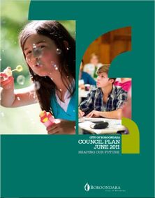
Document (Item), City of Camberwell Council, City of Boroondara Council Plan June 2011, 2011
boroondara, council -
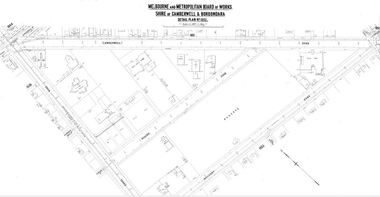 Camberwell Historical Society
Map (Item) - MMBW map, Melbourne and Metropolitan Board of Works, Melbourne and Metropolitan Board of Works - Shire of Boroondara and Camberwell - Detail Plan no. 1852, August 1904
Lithographer L.E, exd W.A.L., August 1904, no. 95. 40P. 15Wmelbourne and metropolitan board of works, map, camberwell, cartography -
University of Melbourne, Burnley Campus Archives
Plan, MIFS Display for University of Melbourne Layout Plan Scale 1:50, 1997 - 2003
1& 2. MIFS Display for University of Melbourne Layout Plan (2003). 3. Design Concept MIFGS University of Melbourne Burnley College (2002). 4.MIFGS Burnley College Display (1997). 5. University of Melbourne Dept. of Environmental Horticulture & Resource Management Proposed MIFGS Display (1997)garden design, melbourne international flower and garden show, burnley college, michael green