Showing 10462 items
matching plans
-
 Kew Historical Society Inc
Plan, J R Mathers & McMillan, Sackville, Thomas & Lytton Streets, Kew, Twentieth Century
The Kew Historical Society's map collection includes a substantial number of real estate subdivision plans, mainly of Kew but also of surrounding suburbs in Melbourne. Most of the subdivision plans date from the 1920s and 1930s when the districts old homes and local farmland were being split up to accommodate residential growth in the postwar period. These early plans were assembled by a local firm, Jas R Mather & McMillan, which had an office in Cotham Road. Many of the plans, and sometimes photos, were annotated by the agents.Subdivision plans are historically important documents used as evidence for the growth of suburbs in Australia. They frequently provide information about when the land was sold as well as evidence relating to surveyors and real estate and financial agents. The numerous subdivision plans in the Kew Historical Society's collection represent working documents, ranging from the initial sketches made in planning a subdivision to printed plans on which auctioneers or agents listed the prices for which individual lots were sold. In a number of cases, the reverse of a subdivision plan in the collection includes a photograph of a house that was also for sale by the agent. These photographs provide significant heritage information relating house design and decoration, fencing and household gardens.The photograph may also be aesthetically significant depending on the importance of the photographic atelier.Lithographed subdivision plan for an un-named estate with 28 allotments facing Lytton, Sackville and Thomas Streets in Kew. The land would have originally formed part of the Dumaresq Estate. subdivision plans - kew, lytton street, sackville street, thomas street - kew -
 Whitehorse Historical Society Inc.
Article, Nunawading historic orchard study, 1992
Story of Nunawading Council's acquisition of the Matheson Orchard and the history of the orchard, to be prepared as a living history of orchard life in 1917 - 1930's.Story of Nunawading Council's acquisition of the Matheson Orchard and the history of the orchard, to be prepared as a living history of orchard life in 1917 - 1930's. Also included a plan of Strathdon Orchard.Story of Nunawading Council's acquisition of the Matheson Orchard and the history of the orchard, to be prepared as a living history of orchard life in 1917 - 1930's.orchards, matheson, charles, city of nunawading, strathdon orchard -
 Warrnambool and District Historical Society Inc.
Document, Drawing of church of Christ Warrnambool, Mid 20th century
These are plans for proposed additions to the Church of Christ in Warrnambool. The date of the drawings and the maker of the plans are unknown. The additions do not appear to have been built. The Church of Christ in Warrnambool was founded in 1875 after a meeting at the Warrnambool Temperance Hall. The building in Spence Street Warrnambool was erected in 1884 at a cost of £1600 and officially opened in 1885. This church was sold and in 2000 the congregation moved to a new building at 186 Raglan Parade (called Gateway Church of Christ).These plans are of some interest as being part of the history of a Warrnambool church – the Church of Christ Warrnambool. These are two rough drawings on cream-coloured paper showing proposed additions to the Church of Christ in Warrnambool. The drawings are in pencil and include the front elevation plan and the first floor plan. The captions are in capital letters. Both pages have tattered edges and are torn across the middle and the pages are stained in places.‘Rough drawing suggested additions for Church of Christ Warrnambool’ ‘Suggested additions for Church of Christ Warrnambool’ church of christ warrnambool, gateway church of christ, history of warrnambool -
 Greensborough Historical Society
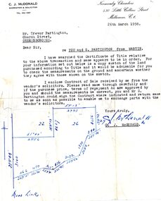
Legal record - Letter, C. J. McDonald, C.J. McDonald to Trevor Partington 1958, 26/03/1958
A solicitor's letter to Trevor [and Gary] Partington in preparation for a land transaction from vendor "Martin". The location of the land is not clear. It is possible that this land was purchased by Alan Partington in his adult children's names.Part of many land deals made by the Partington family in the sale of the original Greensborough farmland. Solicitor's letter, black text on white paperHand drawn plan of property.alan partington, william alan partington, partington family, land deals greensborough -
Moorabbin Air Museum
Document (item) - ASTA - AP (RAN) 201 Vol 1 Book 3 Parts 1 & 2
Jindivik Technical Maintenance Plan -
 Tatura Irrigation & Wartime Camps Museum
Booklet, Streetscape, 1998
Printed in 1998 as a record of the exhibition held at Shepparton Art Gallery, July, 1998. Booklet deals with early architecture in Shepparton Region, includes maps, plans, photographic images and catalogue of 100 years of progress. Soft cardboard, light grey background with Shepparton Post Office fascade and first floor plan on front cover, view of the building from Wyndham Street and ground floor plan on back cover. The word "streetscape" printed across front seven times. early buildings, shepparton art gallery exhibitions, shepparton architecture, shepparton photographic images -
Bendigo Historical Society Inc.
Map - MINING PLAN, Circa 1880's
... plans ...Mining Plan: showing the following companies: New Chum and Victoria Co., South Victoria Co., Lansell's 180, Victoria Quartz Mining Co.topic, mining, plans, mining in bendigo, new chum and victoria co., south victoria co., lansell's 180, victoria quartz ming co. -
 Federation University Historical Collection
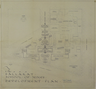
Plan, Ballarat School of Mines Development Plan, 1947, 09/12/1947
The Ballarat School of Mines was future planning before the proposed division of the tertiary division (Mt Helen Campus).Plan of the Ballarat School of Mines Lydiard Street Campus showing existing buildings, proposed demolition of all gaol buildings and court house. ballarat school of mines, development plan, former ballarat gaol, former ballarat court house, lydiard street, master plan, campus plan, ballarat school of mines campus -
 Kew Historical Society Inc
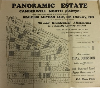
Plan - Subdivision Plan, Panoramic Estate, Camberwell North (Balwyn), 1939, 1939
Subdivision plan advertised as the Panoramic Estate, Balwyn, showing lots for sale in the following streets: Bulleen Road, Macedon Avenue, The Moor, Sunburst Avenue, Doncaster Road, Fortuna Avenue, Longview Road, The Nook, and Touring Avenue.Single page subdivision plan of the Panoramic Estate in Camberwell North (Balwyn); offered for sale in 1939Nilsubdivision plans - balwyn (vic), panoramic estate - camberwell north - balwyn (vic) -
 Melbourne Tram Museum
Document - Personal Papers, H. S McComb, listing various Acts through to Act 2921 and the tramways authorised, 1920's
... Plans ...Set of Quarto and Foolscap hand made papers, listing various Acts through to Act 2921 and the tramways authorised. Set of hand made sketches and notes of cable tram junctions and terminals, with reference to plans and their dates.trams, tramways, tramways, acts of parliament, plans, cable trams -
Glen Eira Historical Society
Plan - Masonic Hall St Georges Rd, 17, Elsternwick
... Plans ...Handrawn floor plans by FJ Maskell undated of the two floors of the Masonic Hall at 17-19 St Georges Rd Elsternwick with cover letter to Mr Scott. Additional handwritten notes added to the floor plans and letter, author unknown.masonic hall, st georges road, scott wv, maskell fj, plans, elsternwick, halls -
 Ringwood and District Historical Society
Letter, Property for sale - Ringwood Shop and Dwelling Estate, Ringwood, Victoria - circa 1925
ID 5225 note: Further information relating to allotments marked on the hand-drawn plan are included in ID 5224 - Ringwood Station Estate.Typewritten letter from A.V. Greenwood with hand drawn plan of Ringwood Shop and Dwelling Estate, detailed description of property for sale, and top and side elevation views of house. (7 pages)(Transcript of first page - to unknown recipient) Phone 988 Central, 331 Canty Greenwood Pty. Ltd. 5 Flinders Street Melbourne. Dear Sir, 1. Attached please find drawings of my house at Ringwood. 2. It is for sale at £4,865 or to let at £5 per week to an approved tenant. 3. I sold it to Mr. De Garis and vacated it, but it is now back on my hands. 4. I leased another place instead of living in my own. I may be able to cancel same; in the meantime, however, I propose to sell or let my own. The painters are now going through the place; re-varnishing, re-oiling and re-polishing so that in about five days it will look "spick and span". 5. The house was specially built under my own supervision. 6. It is very suitable for a high class Guest House, Doctor's residence, Hospital or Convalescent Home. If you know of anyone whom it might suit, please communicate with them. DESCRIPTION 7. It stands on 305 feet of land facing Greenwood Avenue. It is cement, roughcast and hardwood, well oiled, and is now being redone so that the house is as good as new; red tile roof; verandahs three sides; two sleep-outs; five bedrooms; large dining room; very large music room with nooks, upstairs lounge, study; sewing room; built-in wardrobes and cupboards throughout; handsome kitchen with handsome pantry cupboard with drawers and glass front; one bath room; one shower room; wash house with patent copper and laundry. Every modern convenience, hot water system (through copper pipes with large copper cylinder) electric lights everywhere, outside and in, Yan Yean water laid on everwhere throughout house and gardens. Floors throughout are the very best, close set, stained and polished; dainty lead light windows etc. 8. There is a big garage, with tiled roof and two rooms with all conveniences for a married couple. Property is well drained with a system of its own. The house stands upon the top of a hill close to Railway Station, say 500 feet from the Footbridge. 9. The garden has expansive shrubs; sheds; fernery; tennis court. 10. A handsome piece of furniture goes with the house; a combination pantry and storeroom for groceries, milk, bread etc., consisting of drawers, glass and wire doors, as mentioned above. 11. It is within easy distance of Melbourne as it is only two minutes from Ringwood Station, which is a frequent electric train service bringing it within 39 minutes of the City. It is thought better by some to go further out into the country atmosphere and walk a short distance at the end than to go by train 20 minutes then walk 15 to 20 minutes. 12. The price quoted of £4,865 is made up as follows - 305 feet of land @ £5 ... £1,515 Garage and dwelling ... £300 House hot water system, American cupboard ... £2,600 Water, fencing, sheds & drain ... £250 For the lot ... £4,865 Should you require copies of the enclosed drawings I shall be pleased to supply same. 13. Mr. J.B. McAlpin is the local agent, Phone Ring. 7 (after hours Ring. 44) or you may phone me Central 988. 14. The house is south of the line, facing Greenwood Avenue and immediately at the back of Ringwood House, which is also my property. Yours sincerely, A.V. Greenwood (illegible) ..... (Transcript of second page) RINGWOOD SHOP AND DWELLING ESTATE See these letters on plan attached (H.) Ringwood House and Shops on 100 by 150 feet of land fronting Bedford Road 100 feet @ £10 per foot - £1,000 House and shops - £2,400 ... £3,400 Ringwood House consists of Boarding House, (Phone 101) and two shops, mainly brick; 9 inch walls. Will carry another story. Has music room, dining room, entrance halls, 10 bedrooms, large verandahs, all conveniences, hot and cold water, and stands on what will become a most valuable business corner. (F.)(G.) Mr. Greenwood's house, garage and sheds, stands on 307 feet of land fronting Greenwood Avenue. See detailed description attached ... £4,865 (J.) Cottage on Block 81 in William Street ... £750 (K.) Cottage in Pitt Street ... £650 (Total) £9,665 ..... (Description of third page - Subdivision Plan) Drawn by Edyth Greenwood, phone 988 Central. Subdivision includes Station Street, Pitt Street, Bedford Road, Wantirna Road, James Street, William Street (later Kendall Street), Greenwood Avenue, Ellison Street, and Haig Street. Circles denote blocks for sale. Squares denote house properties for sale. Other features marked include location of businesses along Main Street (Maroondah Highway), cool store, railway station, shop and police station on Bedford Road, church on Station Street, site of schoolmaster's residence and State School, and location of proposed public baths -
 Kew Historical Society Inc
Plan - Subdivision Plan, Winton Estate, East Kew : Sale of 10 Building Blocks, 1920
The Kew Historical Society's map collection includes a substantial number of real estate subdivision plans, mainly of Kew but also of surrounding suburbs in Melbourne. Most of the subdivision plans date from the 1920s and 1930s when the districts old homes and local farmland were being split up to accommodate residential growth in the postwar period. These early plans were assembled by a local firm, Jas R Mather & McMillan, which had an office in Cotham Road. Many of the plans, and sometimes photos, were annotated by the agents.Subdivision plans are historically important documents used as evidence for the growth of suburbs in Australia. They frequently provide information about when the land was sold as well as evidence relating to surveyors and real estate and financial agents. The numerous subdivision plans in the Kew Historical Society's collection represent working documents, ranging from the initial sketches made in planning a subdivision to printed plans on which auctioneers or agents listed the prices for which individual lots were sold. In a number of cases, the reverse of a subdivision plan in the collection includes a photograph of a house that was also for sale by the agent. These photographs provide significant heritage information relating house design and decoration, fencing and household gardens.The photograph may also be aesthetically significant depending on the importance of the photographic atelier.Subdivision plan for the so-called Winton Estate in East Kew. The Estate comprised 10 lots facing Simpson Street and Campbell Street. The estate was auctioned by Jas. R. Mathers, Son and McMillan. campbell street, simpson street, hunter street, normanby road - kew, subdivision plans - east kew, subdivision plans - kew -
 Surrey Hills Historical Society Collection
Compact disc, Beyond the Garden Wall Project Powerpoint presentation, Dec 2008
Date Made :Dec 2008 Region/State Made: Surrey Hills Selected photographic record as a powerpoint presentation. Part of the acquitted reporting back to DPCD (Dept of Planning and Community Development)Selected photographic record as a powerpoint presentation. Part of the acquitted reporting back to DPCD (Dept of Planning and Community Development)gardening, gardeners, gardens-boroondara -
Southern Sherbrooke Historical Society Inc.
Map - photocopy
A photocopy taken from the original land sale map provided to the society through Karel Coxell of Stockdale & Leggo. The original maps are stored in large bound account books and were originally the propert of McNally Real Estate. The books are held (in 2A3 photocopy of plan of survey of part of Crown Allotments 20 & 21, section C, parish of Narre Worran, County of Mornington. Clements Ave and environs in Belgrave Heights"Villette Estate" in top LH corner, "Locality Plan" in bottom LH corner, "Not in sale" written on one block and crossed out. All handwritten in pencil on original. "Colby Drive " and "Verona Street" added in pencil to copy.land sales, advertisements, subdivision -
Glenelg Shire Council Cultural Collection
Work on paper - Public Baths for the Borough Council of Portland
Colour plans showing the public baths of Portland. Top right is the title. Depicts the South Side Elevation, West Front Elevation and swimming area as well as several sectionsThis is the plan ***** to the Contrct / entered into this Tenth day of October 1888 / for the erection of the new Baths for the Borough of / Portland Top Right Public Baths / For the / Borough Council / of / Portland / Wm Mackay / archt Scale 16 Feet TO 1 Inchportland baths, borough of portland, william mackay -
Port Melbourne Historical & Preservation Society
Plan - Water cart used in road construction, Borough of Sandridge, 21 Nov 1870
From a group of maps and plans not required by the Port Melbourne Council Engineering Department in May 1994 and offered at that time to the Port Melbourne Historical Society.Plan of water cart used in road construction including 4 diagrams and scales: signed by Borough Surveyor, Nov 21 1870.built environment - civic, engineering, engineering department - borough of sandridge -
 Ringwood and District Historical Society
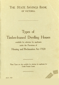
Booklet, Types of Timber Framed Dwelling Houses, Victoria, 1927
Plans show how the modern house has progressed and evolved since 1920.Grey covered booklet of plans for 53 dwelling houses available for selection by applicants under the Housing and Reclamation Act 1920. Published by the State Saving Bank of Victoria -
 Ballarat Tramway Museum
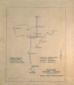
Drawing - Proposed Fares, State Electricity Commission of Victoria (SECV), "Ballaarat Tramway System", 1949
The plan prepared by the SECV shows proposed fares, an increase of 1d on existing fares, and the through routing of tram services. Scale of 40 chains to 1". Alligns with August 1949 Fare By-Law - see item 3111. See also the pdf file "Ballarat Tramway Fares Changes SEC Era", by Warren Doubleday, 03-09-2006.Demonstrates aspects of the way the SEC prepared plans showing tram and ticketing arrangements.Plan titled "Ballaarat Tramway System" - multi-coloured on paper with pencil notations.tramways, ballarat, secv rules, by-laws, tickets, fares -
Tatura Irrigation & Wartime Camps Museum
Map - plan, Engineer for Contruction Railways Dept, Toolamba and Tatura Railway, 18 August 1879
Original plan2 sheets stapled together, white paper. Plan of proposed railway line drawn in ink. Names of property owners transverse shown. Roads show. Existing buildings, dams (tanks), wells and railway culverts.Victorian Railways. signed by Engineer in ink.victorian railways plans -
Whitehorse Historical Society Inc.
Pamphlet, Slater Reserve, c1988
Leaflet with information about Slater Reserve in Blackburn North.Leaflet with information about Slater Reserve in Blackburn North. described as a multi-purpose recreation facility it lists facilities and play equipment. A plan of the reserve is included.Leaflet with information about Slater Reserve in Blackburn North. slater reserve, multi-purpose -
 Whitehorse Historical Society Inc.
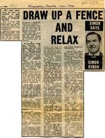
Article, Draw up a fence and relax, 1976
Column by journalist Simon Kinch.Column by journalist Simon Kinch, including musings on council requirements for fence plans, road traffic problems in Vermont South and the meanings of the acronym NADRASCAColumn by journalist Simon Kinch.fences, vermont south, nadrasca -
 Kew Historical Society Inc
Plan, Melbourne & Metropolitan Board of Works : Borough of Kew : Detail Plan No.1582, 1904
The Melbourne and Metropolitan Board of Works (MMBW) plans were produced from the 1890s to the 1950s. They were crucial to the design and development of Melbourne's sewerage and drainage system. The plans, at a scale of 40 feet to 1 inch (1:480), provide a detailed historical record of Melbourne streetscapes and environmental features. Each plan covers one or two street blocks (roughly six streets), showing details of buildings, including garden layouts and ownership boundaries, and features such as laneways, drains, bridges, parks, municipal boundaries and other prominent landmarks as they existed at the time each plan was produced. (Source: State Library of Victoria)This plan forms part of a large group of MMBW plans and maps that was donated to the Society by the Mr Poulter, City Engineer of the City of Kew in 1989. Within this collection, thirty-five hand-coloured plans, backed with linen, are of statewide significance as they include annotations that provide details of construction materials used in buildings in the first decade of the 20th century as well as additional information about land ownership and usage. The copies in the Public Record Office Victoria and the State Library of Victoria are monochrome versions which do not denote building materials so that the maps in this collection are invaluable and unique tools for researchers and heritage consultants. A number of the plans are not held in the collection of the State Library of Victoria so they have the additional attribute of rarity.Original survey plan, issued by the MMBW to a contractor with responsibility for constructing sewers in the area identified on the plan within the Borough of Kew. The plan was at some stage hand-coloured, possibly by the contractor, but more likely by officers working in the Engineering Department of the Borough and later Town, then City of Kew. The hand-coloured sections of buildings on the plan were used to denote masonry or brick constructions (pink), weatherboard constructions (yellow), and public buildings (grey). Public buildings, coloured grey on the Plan 1582 include the police station and post office, churches and schools. The earliest church school, Common School No.356 was located at the rear of the Congregational Church in Peel Street. It was constructed in 1859. The first buildings of Kew Primary School No.1075 on the other side of Peel Street were constructed in 1871. The school in 1903 only occupied a small fraction of its current site. In 1903, where the rear playground is now located, were two weatherboard and one brick villa. Trinity Grammar School was founded in 1902 and opened in the Parish Hall at the rear of Holy Trinity Anglican Church. It was not to move to its current site until 1906. The outline of the building housing the Kew Fire Brigade in the centre of the north side of Walton Street is shown but not named on the plan. Further down Pakington Street stood the two-storey Italianate mansion ‘Overton’. The home of Stanford Chapman, it was to be featured in the Imperial Institute series of bromide photographs of Victoria, Vol. 1: Homes and scenery. It was later to become a boarding house before it was later demolished.melbourne and metropolitan board of works, detail plans, maps - borough of kew, mmbw 1582, cartography -
 Kew Historical Society Inc
Plan, Melbourne & Metropolitan Board of Works : Borough of Kew : Detail Plan No.1588, 1904
The Melbourne and Metropolitan Board of Works (MMBW) plans were produced from the 1890s to the 1950s. They were crucial to the design and development of Melbourne's sewerage and drainage system. The plans, at a scale of 40 feet to 1 inch (1:480), provide a detailed historical record of Melbourne streetscapes and environmental features. Each plan covers one or two street blocks (roughly six streets), showing details of buildings, including garden layouts and ownership boundaries, and features such as laneways, drains, bridges, parks, municipal boundaries and other prominent landmarks as they existed at the time each plan was produced. (Source: State Library of Victoria)This plan forms part of a large group of MMBW plans and maps that was donated to the Society by the Mr Poulter, City Engineer of the City of Kew in 1989. Within this collection, thirty-five hand-coloured plans, backed with linen, are of statewide significance as they include annotations that provide details of construction materials used in buildings in the first decade of the 20th century as well as additional information about land ownership and usage. The copies in the Public Record Office Victoria and the State Library of Victoria are monochrome versions which do not denote building materials so that the maps in this collection are invaluable and unique tools for researchers and heritage consultants. A number of the plans are not held in the collection of the State Library of Victoria so they have the additional attribute of rarity.Original survey plan, issued by the MMBW to a contractor with responsibility for constructing sewers in the area identified on the plan within the Borough of Kew. The plan was at some stage hand-coloured, possibly by the contractor, but more likely by officers working in the Engineering Department of the Borough and later Town, then City of Kew. The hand-coloured sections of buildings on the plan were used to denote masonry or brick constructions (pink), weatherboard constructions (yellow), and public buildings (grey). This plan shows the original configuration of the Kew Post Office, Court House and Police Station, which had opened in 1888. This configuration was to essentially remain until the purchase of the Court House and Police Station by the City of Boroondara in 2007 and its subsequent renovation. Interestingly, the MMBW surveyors incorrectly labelled parts of the complex. In the triangle in front of the Post Office, before the erection of the Kew Cenotaph in 1925, was located a lawn and the Queen Victoria Jubilee Fountain. While many of the shops on the south side of High street had been constructed by 1903 a number of sites were still used as vegetable gardens. Further along High Street, on the corner of Charles Street, the Salvation Army Barracks can be seen on the plan. These Barracks predate the later Citadel and ‘Young People’s Hall’ that were opened in 1919. At 22 Charles Street can be seen the house of James Venn Morgan. Hailed as the ‘father of Kew’, Morgan arrived in Melbourne in 1840. He was first engaged as a bookmaker, but a fortunate venture on the goldfields enabled him to purchase land in Kew. He conducted a market garden and dairy in Kew for many years.melbourne and metropolitan board of works, detail plans, maps - borough of kew, mmbw 1588, cartography -
 Kew Historical Society Inc
Plan, Melbourne & Metropolitan Board of Works : Borough of Kew : Detail Plan No.1591, 1905
The Melbourne and Metropolitan Board of Works (MMBW) plans were produced from the 1890s to the 1950s. They were crucial to the design and development of Melbourne's sewerage and drainage system. The plans, at a scale of 40 feet to 1 inch (1:480), provide a detailed historical record of Melbourne streetscapes and environmental features. Each plan covers one or two street blocks (roughly six streets), showing details of buildings, including garden layouts and ownership boundaries, and features such as laneways, drains, bridges, parks, municipal boundaries and other prominent landmarks as they existed at the time each plan was produced. (Source: State Library of Victoria)This plan forms part of a large group of MMBW plans and maps that was donated to the Society by the Mr Poulter, City Engineer of the City of Kew in 1989. Within this collection, thirty-five hand-coloured plans, backed with linen, are of statewide significance as they include annotations that provide details of construction materials used in buildings in the first decade of the 20th century as well as additional information about land ownership and usage. The copies in the Public Record Office Victoria and the State Library of Victoria are monochrome versions which do not denote building materials so that the maps in this collection are invaluable and unique tools for researchers and heritage consultants. A number of the plans are not held in the collection of the State Library of Victoria so they have the additional attribute of rarity.Original survey plan, issued by the MMBW to a contractor with responsibility for constructing sewers in the area identified on the plan within the Borough of Kew. The plan was at some stage hand-coloured, possibly by the contractor, but more likely by officers working in the Engineering Department of the Borough and later Town, then City of Kew. The hand-coloured sections of buildings on the plan were used to denote masonry or brick constructions (pink), weatherboard constructions (yellow), and public buildings (grey). That area of Kew bordered by Cotham Road, Park Hill Road, Ermington Lane (now Ermington Place), and Belmont Avenue contained some of the significant homes owned by Kew pioneers. Chief among these was ‘Park Hill’ on an enormous lot facing Park Hill Road. The Jubilee History of 1910 noted, six years after this plan was drawn, that: ‘Park Hill Road, forming the southern boundary of the cemetery, takes its name from Park Hill, the residence of Mr. Thomas Judd, who has resided there since December, 1852.’ Other named houses on the plan include ‘Ferndale’ facing Cotham Road; ‘Ermington’ adjacent to Judd’s Park Hill, facing Park Hill Road; and ‘Gilden’ and ‘Mont Belmont’ facing Belmont Avenue. Mont Belmont was designed by the architectural firm of Reed, Henderson and Smart for William George Lilley in 1887 and was completed in 1888. Lilley was Mayor of Kew in 1887-88, a Justice of the Peace and a member of the first Board of Guardians of Kew’s St. Hilary’s Church of England.melbourne and metropolitan board of works, detail plans, survey plans - borough of kew, mmbw 1591, cartography -
 Kew Historical Society Inc
Plan, Melbourne & Metropolitan Board of Works : Borough of Kew : Detail Plan No.1574, 1905
The Melbourne and Metropolitan Board of Works (MMBW) plans were produced from the 1890s to the 1950s. They were crucial to the design and development of Melbourne's sewerage and drainage system. The plans, at a scale of 40 feet to 1 inch (1:480), provide a detailed historical record of Melbourne streetscapes and environmental features. Each plan covers one or two street blocks (roughly six streets), showing details of buildings, including garden layouts and ownership boundaries, and features such as laneways, drains, bridges, parks, municipal boundaries and other prominent landmarks as they existed at the time each plan was produced. (Source: State Library of Victoria)This plan forms part of a large group of MMBW plans and maps that was donated to the Society by the Mr Poulter, City Engineer of the City of Kew in 1989. Within this collection, thirty-five hand-coloured plans, backed with linen, are of statewide significance as they include annotations that provide details of construction materials used in buildings in the first decade of the 20th century as well as additional information about land ownership and usage. The copies in the Public Record Office Victoria and the State Library of Victoria are monochrome versions which do not denote building materials so that the maps in this collection are invaluable and unique tools for researchers and heritage consultants. A number of the plans are not held in the collection of the State Library of Victoria so they have the additional attribute of rarity.Original survey plan, issued by the MMBW to a contractor with responsibility for constructing sewers in the area identified on the plan within the Borough of Kew. The plan was at some stage hand-coloured, possibly by the contractor, but more likely by officers working in the Engineering Department of the Borough and later Town, then City of Kew. The hand-coloured sections of buildings on the plan were used to denote masonry or brick constructions (pink), weatherboard constructions (yellow), and public buildings (grey). This plan shows several very large houses, particularly along Glenferrie Road, and the area now occupied by Ruyton Girls’ School. ‘Tarring’ (incorrectly spelled here as ‘Karring’) was built for Henry Henty in 1872, on part of his original allotment of 20 acres, and ‘Mount View’, which retains its original building and the fountain in the front garden, is part of Ruyton’s Junior School. The most significant change to Tarring and its grounds since 1903, involve the removal of a number of the outbuildings, including a Burmese temple, bought by Henty from the Burmese Exhibit at the Great Exhibition of 1880. It is shown on the plan as a summerhouse. The two-storey mansion, on the corner of Glenferrie Road and Wellington Street, was built in 1891 by leading architect Alfred White as his own home. Having an initial N.A.V. of £160, the house was purchased by a warehouseman Henry Lister, by 1900, when the N.A.V. was recorded at £111. By the turn of the century the house was known as ‘Comaques’. By contrast, much smaller houses are shown in Scott and Byron Streets, including a tiny Mission Hall in Byron Street, which belonged to the Anglican Church from at least 1903 to 1917.melbourne and metropolitan board of works, detail plans, maps - borough of kew, mmbw 1574, cartography -
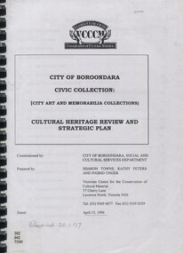 Surrey Hills Historical Society Collection
Book, City of Boroondara Civic Collection: (City Art and Memorabilia Collections) Cultural Heritage Review and Straegic Plan, 1996
This publication explains an approach to manage the collection and develop a strategic plan for its exposure to the public through community participation and access, interpretations and exhibitions.This publication explains an approach to manage the collection and develop a strategic plan for its exposure to the public through community participation and access, interpretations and exhibitions.boroondara council - art collections, art ad state, cultural policy, boroondara history -
University of Melbourne, Burnley Campus Archives
Plan, Plan of Gardens, c. 1940?
Hand drawn plan of Gardens with some colour, on reverse of unused Certificate. Shows paths and beds in Ornamental Garden with grids drawn in pencil for planting lists. 2 photocopies of enlarged portion.Plan is drawn on verso of unused Diploma certificate from Royal Horticultural School Burnley, Department of Agriculture Victoria, with illustration of old Pavilion. On reverse, "Mr Kneen, Principal School of Horticulture Burnley," handwritten in pencil.ornamental gardens -
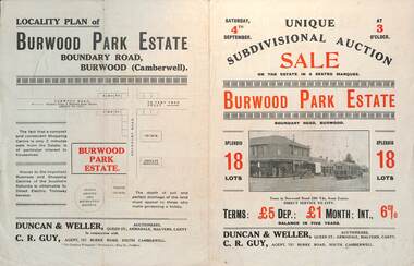 Melbourne Tram Museum
Ephemera - Real estate sale, Duncan & Weller Auctioneers, "Burwood Park Estate" Boundary Road, 1926
Pamphlet advertising the sale of land at the Burwood Park Estate, Boundary Road Burwood, Saturday 4th September. Does not give the year, most likely 1926. Promotes the tram service, nearby shops, the suitability of the soil for gardening and other facilities. Has a photo of possibly W 259 at the terminus. The plan of sub-division shows 18 lots for sale.Demonstrates the style of land sale pamphlet including the availability of tram services to prospective purchasers.Pamphlet - folded - printed in two colours of cream coloured paper with photographs and plans.sale of land, trams, real estate, burwood park, burwood -
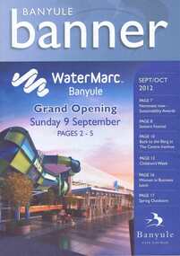 Greensborough Historical Society
Document collection, Banyule City Council, Watermarc, Greensborough, 2004-2012
The development of the Greensborough town centre and in particular the redevelopment of the Greensborough Pool into the Watermarc aquatic centre is documented in this collection of minutes, correspondence, plans, brochures, etc. Contents: Box 1, Correspondence, Project updates, Leaflets, Plans, Newspaper articles. Community Consultative Committee meetings - Agendas and Minutes. Box 2: Greensborough Project Presentation Package 2006; Greensborough principal activity centre plan (executive summary 2005, 2008); Consultation documents 2005; Banyule Banner (2005; 2006); Project update 2005; Newspaper article collection; Advertising leafletsThis collection is significant as it covers the development of the pool precinct from concept plan to completed complex.A collection of various documents relating to the development of the Watermarc pool complex. Includes leaflets, plans, minutes of committee meetings and letters to committee member (in black ring binder).watermarc, greensborough, greensborough pool, swimming pools, rosalie bray, banyule city council