Showing 662 items matching " port development"
-
 Port Fairy Historical Society Museum and Archives
Photograph
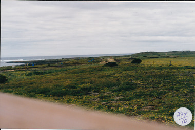
South Beach Development Coloured photograph of South beach estate, blue marks are tree plantings along track397/10 (since removed 2021)south beach, development, road, road making, estate -
 Port Fairy Historical Society Museum and Archives
Photograph
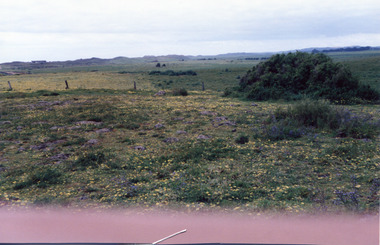
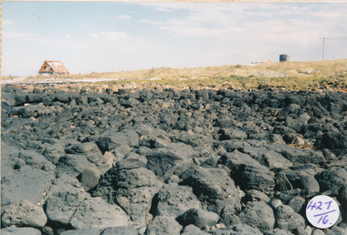
South Beach Developement Coloured photograph of Rocky outcrop looking towards dunessouth beach, development, bluestone, west -
 Port Fairy Historical Society Museum and Archives
Photograph
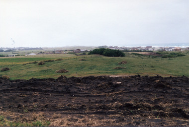
South Beach Developement Coloured photograph of Earthworks in foreground with a tree shelter belt in middle distance and South Beach Estate in distancesouth beach, development, road making, street -
 Port Fairy Historical Society Museum and Archives
Photograph, Jock Varcoe, c.1980
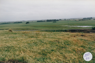
South Beach Development looking toward princes highwayColoured photograph of rolling hills and farmlandsouth beach, development, princes highway, farmland, swamp -
 Port Fairy Historical Society Museum and Archives
Photograph
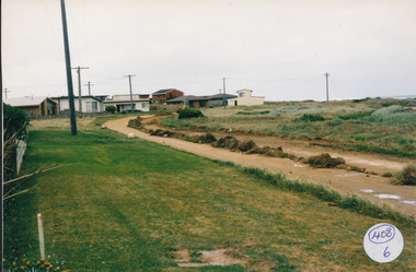
South Beach Development Coloured photograph of Ocean Drive being graded and widened408/6 since been removed (2021)south beach, development, road making, ocean drive -
 Port Fairy Historical Society Museum and Archives
Photograph
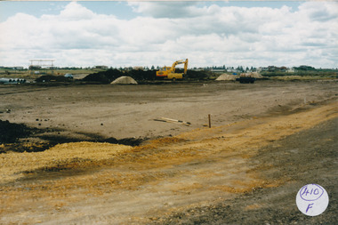
South Beach Development Coloured photograph of Drainage works with pipes at the left and large machine 410/F (sticky label now removed 2021)south beach, development, earth works, equipment, digger -
 Port Fairy Historical Society Museum and Archives
Photograph
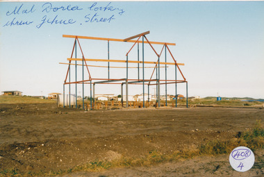
South Beach Development south beach, development, mal dora, house, building, jehu street -
 Port Fairy Historical Society Museum and Archives
Photograph
South Beach Developement south beach, development, house, building, street, road -
 Port Fairy Historical Society Museum and Archives
Photograph
South Beach Development south beach, development, ocean drive, mal dorea, house building, road, street -
 Port Fairy Historical Society Museum and Archives
Photograph
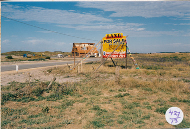
South Beach Development south beach, development, sale, sign, mal dora, house, building -
 Port Fairy Historical Society Museum and Archives
Photograph
South Beach Development looking from rocks to Mal Dorea’s housesouth beach, development, rocks, bluestone, mal dorea, house, building -
 Port Fairy Historical Society Museum and Archives
Photograph
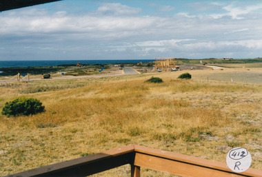
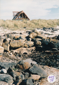
South Beach Development looking toward Mal Dorea’s new house from the beach Coloured photograph of rocks and drain on beach looking at unfinished A framed house in backgrounsouth beach, development, mal dorea, house, building, bluestone, beach -
 Truganina Explosives Reserve Preservation Society Inc (TERPS)
Digitised Oral History – Truganina Explosives Reserve - Tape 7 Cliff Gibson, 2018
The interviews were recorded in 2000 by Bronwen Gray and Alan Young for the production of Unreserved, Stories from Truganina Explosives Reserve, animated stories from past residents, workers and interested people of the Reserve (subject to copyright 2004). Cliff Gibson, a Williamstown resident, discusses the handling and shipping of explosives in the Port of Melbourne between 1863 to 1962 and the establishment, development and history of Truganina Explosives Reserve. In the interview he mentions the names of the Lighters and Ships used to transport the explosives to and from the Truganina Explosives Reserve. A primary source of information on memories of the Truganina Explosives Reserve and Altona,Victoriaexplosives, lighter, sailing lighters, the brig martha, deer park, australian chemical company, nobel explosives company, ici, james scott and company, jacks magazine, william wardell, george thomas chirnside, 1897, 1901, pier, bill grant, james mullins, 2 foot gauge tramway, explosives trucks, explosive magazines, railway explosives vans, queen street, richard rendle holten, ports and harbours, the lighter truganina, the lighter george stone, rose, mary jane, tarniet, derrimut, boonah, deutgam, naval dockyards williamstown, charlie curry, powder barges, cargo net, alma doepel, huia, wongalla, joseph sims, argonaut, maryland, pirie, lady isobel, taranui, point wilson, failee, captain dyson, hector pirie -
 Friends of St Brigids Association
Book - Budget Estimates 1 September 2011. Concept Development of a Cultural Centre St Brigid’s Australian-Irish Cultural & Heritage Centre, Challisdesign. 2011. Budget Estimates 1 September 2011. Concept Development of a Cultural Centre St Brigid’s Australian-Irish Cultural & Heritage Centre. North Geelong: Challis design Pty Ltd
-
 Melbourne Legacy
Document, Letter from Legatee Donovan Joynt, 1980s
A letter about the Shrine that was sent by Legatee Donovan Joynt to the President. The date is unknown. He outlines concern that buildings that are proposed along St Kilda road will block the view of the Shrine from different perspectives. The original plans of the Shrine being at the Domain site emphasised that it would be visible on many axis, including from a ship passing through the heads of Port Phillip Bay. He accuses Legacy of being lax in fighting for the original plans being upheld and fighting inappropriate development. Was in a binder of documents that is passed from an outgoing President to the incoming President. It is primarily from the 1930s to 1990s. Most documents are being catalogued separately.A record of a concern by a Legatee about the sanctity of the Shrine being encroached upon by inappropriate buildings nearby.White A4 paper x 2 pages with black type of an undated letter from Legatee Donovan to the President.Signed in pencil 'Donovan Joynt'.shrine of remembrance, donovan joynt -
 The Celtic Club
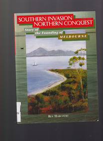
Book, Rex Harcourt, Southern invasion, northern conquest: Story of the founding of Melbourne, 2001
This book is an account of how exploration and settlement of Port Phillip paved the way for colonising present day Victoria.Index, bib, plates, maps, ill. p. 240.non-fictionThis book is an account of how exploration and settlement of Port Phillip paved the way for colonising present day Victoria.exploration and development - melbourne, john batman - melbourne - history -
 Wodonga & District Historical Society Inc
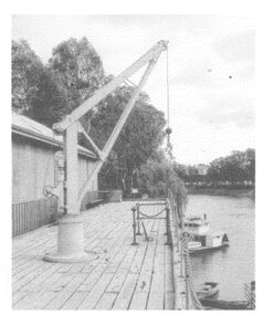
Photograph - The River Port of Red Bank
THE RIVER PORT OF REDBANK During the 1870s, Red Bank would have been one of the busiest ports on the Murray River. When the railway line was being built from Melbourne to Wodonga all the railway material was brought up river from Echuca by paddle steamer and barge and unloaded at Red Bank. The material was loaded onto horse teams or bullock wagons and taken along the route of the spur line. During the 187 MacCulloch & Co. handled 3000 tons of railway material here' The port was operational from approximately 1870 until 1874. THE FIG TREES The fig trees and a small bank of gravel are the only visible reminders of where the spur line from the wharf at Red Bank met the main line. It was at this point that all the material for the mainline was transferred from the small locomotives and wagons from Red Bank. It would have been carried by bullock wagons and horse teams and unloaded at different places as the line progressed. After the line was completed in 1873 the fettlers from Wodonga would patrol this length of the line.These images are significant because they document an important stage in the development of transportation in North East Victoria.Images of the River Port of Red bank near Wodonga on the Murray River. 1. The wharf 2. All that remainsred bank port, historic wharf wodonga, river transport -
 Wodonga & District Historical Society Inc
Map - Boorgunyah - "The Town that never was"
At the height of the river trade, there was a town surveyed and laid out, and streets were named. This town was to house the workers at the river port of Red Bank when the paddle steamers plied the Murray River as far as Albury, carrying produce such as wool and wheat to the various towns along the river in the 1800s. As the river trade died away, this town never went ahead – one might say, “The town that never was.” A lone gum tree stands on the site today.This item is significant because it documents plans which were made for the early development of Wodonga.A black an white map depicting the proposed location of the township. The map is based on a sketch and is not to scale,early wodonga, boorgunyah - "the town that never was", wodonga heritage -
City of Kingston
Photograph - Colour, 29 January 1993
Bonbeach, Carrum and Patterson Lakes are suburbs in the City of Kingston. Bonbeach and Carrum were holiday destinations in early 20th century and over time the housing has converted to permanent residential structures. In Patterson Lakes, the area consists predominantly of newer housing developments and the tidal canal system which is accessible to many dwellings joins Port Phillip Bay.Bonbeach, Carrum and Patterson Lakes were previously part of the extensive Carrum Carrum Swamp. The area was once a source of fish and eels for the Mayone-Bulluk clan of the Bunurong people. Over time the area was drained and this allowed farming at Carrum and Bonbeach, although the area was prone to flooding. In the early 1920s and 30s the land was converted to residential dwellings. In 1973 investigations commenced nearby to Bonbeach and Carrum into the development of a unique residential area comprising canals and waterways. It was originally proposed to be known as "Gladesville". Circa 1974, the area was rezoned from rural to residential and named Patterson Lakes. Development has been continuous since the 1970s with staged construction of the waterways, residential housing, and supporting infrastructure and facilities.Laminated colour aerial photograph of the Bonbeach, Carrum and Patterson Lakes region within City of Kingston. This 1993 image includes Bonbeach High School prior to demolition, Bonbeach Primary School and Patterson River Golf Club. Sections of Patterson Lakes are not yet developed, including Rhode and Staten Islands. Long Island Point appears to be a recent development with many spare blocks and new houses under construction. The Patterson River marina is prominent and the river mouth as it meets Port Phillip Bay. The Carrum railway station is visible.Black type on white adhesive sticker: No. 6661 Black type on white adhesive sticker: 26E/6661, 29/1/93, 4.25 pm Black type on white adhesive sticker 29-1-93 Yellow circular adhesive stickerbonbeach, carrum, patterson lakes, patterson river, carrum carrum swamp, canals and waterways -
 City of Kingston
Photograph - Black and white, c. 1920
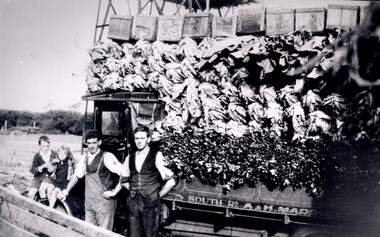
Market gardening was an integral part of the development of the area now known as Kingston. In this image there are two men standing beside a truck loaded with vegetables. Painted on the truck are the words South Rd, A & H Marriott, indicating these men are from the Marriott family. The truck appears to be a Republic Commercial Car by Republic Motor Truck Co, Michigan, c. 1916.The Marriott family arrived in Port Phillip in 1857. It wasn't until 1876 that the family purchased 30 acres with a four-roomed house in East Boundary Road, in the area then called East Brighton.Black and white image of two men standing in front of a truck fully loaded with vegetables intended for market. There are also two children standing in front of the truck.Handwritten in black ink on a round red sticker on the reverse: X18 Handwritten in red ink on reverse: 35% -
 Flagstaff Hill Maritime Museum and Village
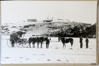
Photograph - Scene - Warrnambool, C. 1854-1871
This is an image of the Warrnambool Lighthouse Complex on Middle Island in 1854. The Store, Lighthouse Keeper's Quarters, Lighthouse and Flagstaff are in the background. The foreground shows a covered buggy drawn by two horses and a person in attendance, and another wheeled vehicle behind it with a figure nearby. There is a saddled horse to the right with two males in conversation nearby. The ground is soft, perhaps the riverbed or sandy shore. THE LIGHTHOUSE KEEPERS Lighthouse Keepers were responsible for keeping their Lighthouse’s lights shining at night. They kept a lookout for passing vessels and changes in weather. They were expected to clean, polish and maintain the equipment and buildings. They kept regular and detailed records of who was on watch, and the time the light was lit, trimmed and extinguished. They kept a journal about other events that occurred. They keep regular, accurate Meteorological Logs. It was expected that they were competent in Morse code signalling. They would be called to help in times of disasters and shipwrecks and to give official statements about these events. Many Lighthouse Keepers also volunteered as members of the lifeboat crew. The Lady Bay lighthouses were officially classified as small, so the Keepers had the official titles of Senior Assistant Lighthouse Keeper and Assistant Lighthouse Keeper. They were employed by the Public Service and paid rent to live in the Lighthouse Quarters. They were compulsorily retired at the age of 60, with most receiving a superannuation payment. Despite their time-consuming duties, there was time to follow hobbies and crafts such as growing vegetables, playing musical instruments, making models of buildings including lighthouses, and crafting furniture pieces. An example of a keeper’s skills is the carved fire screen made by /assistant Keeper Thomas Hope in the late 19th century and displayed in the Lighthouse Keeper’s cottage at Flagstaff Hill. Both Alexander and Farncombe had served under Senior Keeper Robert Deverell, who was the first and only Senior Lighthouse Keeper at the Middle Island Complex. John Alexander was the Assistant Keeper in the 1850s. Andrew Farncombe was the last Assistant Keeper at Middle Island, serving there with his family from 1864 to 1871. During 1871 and 1872 the Lighthouse Complex was moved to Flagstaff Hill on Merri Street. Farncombe and Deverell then became the first Keepers and occupants of the Lady Bay Lighthouse Complex at Flagstaff Hill. They continued their service together; overall, Deverell served from 1859 to 1885 and Farncombe from 1864 to 1974. WARRNAMBOOL'S LADY BAY LIGHTHOUSE COMPLEX - The original Lighthouse Complex was built on Middle Island in 1858-1859 then transferred stone-by-stone to Flagstaff Hill in 1871. The Complex comprised the Lighthouse, the Lighthouse Keepers’ Quarters and a Privy. The bluestone Keeper’s Quarters was a cottage divided into two compartments, one for the Senior Keeper and his family, the other for the Assistant Keeper and his family. The bluestone Store was divided into three; a store, a workshop, and an oil store (or office). The Privy comprised a small building also divided into two separate, back-to-back toilets, one for each Keeper and his family. In the 1970s the Flagstaff Hill Planning Board was set up under the chairmanship of John Lindsay. The Board was to make recommendations to the Warrnambool City Council regarding the use of the buildings and the rest of the Crown Land on the site. The Flagstaff Hill Maritime Village opened in 1975 and began renovating the Cottage in stages, during which time evidence of a 1920s fire was found in the eastern section of the cottage. Additions of a porch on the west and a washroom on the east were made in the 1980s. The western part of the building is now a Shipwreck Museum and the east has returned to a late 19th-century Lighthouse Keeper’s cottage and includes the screen made by Assistant Lighthouse Keeper Thomas Hope in the late 19th century. Hope served two periods of time at the Lighthouse. This photograph is significant as a visual record of the original Warrnambool Lighthouse Complex on Middle Island, the origin of what is now the Lady Bay Lighthouse Complex. The photograph is significant for its connection to the Complex, which is now listed on the Victorian Heritage Register, H1520, for being of historical, scientific (technological) and architectural significance to the State of Victoria. The Complex is significant as an example of early colonial development. The photograph is significant for its connection with the important navigational function of the Lighthouses, a function still being performed to this day. The photograph is also significant as it shows an example of buildings organised by the Public Works Department in Victoria in the mid-to-late 19th century. The structures tare still stand strong. Photograph of horses, a buggy and three gentlemen in the foreground and the background shows a lighthouse and accompanying buildings. Printed in black and white. (Another two horse-drawn vehicles are partially visible). The subject is the Lighthouse Complex on Middle Island, Warrnambool, dated between 1854 and 1871.An inscription is handwritten in black pen on the back of the mounting board."The lighthouse and accompanying buildings were / established on Middle Island in 1854, as this / picture shows. In 1871 they were moved to their / present site on Flagstaff Hill."flagstaff hill, flagstaff hill maritime museum, flagstaff hill maritime village, warrnambool, maritime museum, shipwreck coast, lighthouse keeper's cottage, lighthouse residence, lighthouse, chart room, quarters, privy, middle island, beach lighthouse, obelisk, lighthouse complex, lady bay complex, warrnambool port, warrnambool harbour, lady bay, keepers, lighthouse keeper, upper lighthouse, lower lighthouse, assistant keeper, ports and harbours, cottage, meteorological record, 1854, 1871 -
Port Melbourne Historical & Preservation Society
Book - Borough of Port Melbourne Valuation 1895, 1895
Valuation book, Borough of Port Melbourne 1895. Bluegreen marbled cover, maroon spine gold-stamped front label. 74 of 89 spreads completed listing name and occupation of tenant and owner of each property, description, number of rooms, size of property, rental etc. Two page insert stitched into 74, being letter from valuer handwritten on lined paper, detailing new development as well as houses demolished. (also Rates; assessments)local government, built environment, joseph turner -
Port Melbourne Historical & Preservation Society
Audio - PMHPS Meeting, Adair Bunnett, Comparing settlement of South and Port Melbourne, David Nicholas, 23 Apr 2018
Adair Bunnett discusses the similarities and differences between the development of settlements in South and Port Melbourne PMHPS monthly meeting 26.02.2018 Duration including meeting preliminaries 1:07:24local government, natural environment, south melbourne, adair bunnett -
Lakes Entrance Historical Society
Book, Heritage Victoria and Central Gippsland Development Board, Gippsland Heritage Project Prospectus, 1996
Prospectus of Gippsland Heritage Project identifying aims of project and groups involved, featuring Port Albert, first Maritime Gateway to Gippsland, and map of Heritage Icons.heritage, township, social history -
Port Melbourne Historical & Preservation Society
Audio - Oral History, Bayside Development Proposal, Ronald 'Bunna' Walsh, 14 Jul 2004
Oral History from Ronald "Bunna" Walsh on Bayside Development Proposal (discussing the proposed Sandridge City development). Recording made by Janet Bolitho at Port Town Hall on 14.07.2004 Recording duration 25:26built environment, town planning - proposals shelved, ronald 'bunna' walsh -
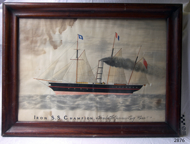 Flagstaff Hill Maritime Museum and Village
Painting - Lithograph, Iron S.S. Champion Frank Helpmann Esq. Comr, 1853 or later
Captain Benjamin Francis (Frank) Helpmann was once the owner of the S.S. CHAMPOIN, then owned it in partnership with S. G. Henty. S.S. CHAMPION was an early steamship and one of the first coastal traders to operate between Melbourne and Portland in Victoria from December 1853 until August 1857, when she collided with the S.S. LIRDY BIRD in the open sea off Cape Otway. CHAMPION was returning from Melbourne, and sank with thirty-two people still on board. The thirty others were saved by the LIRDY BIRD (ref. The Story of a Port : Portland, Victoria, by Noel F. Learmonth)This picture Lithograph) is associated with the S.S. Champion, which is listed on the Victorian Heritage Database VHR S110. The wreck of the SS Champion is significant historically as one of Victoria's worst shipwrecks. As an early steamship it played an important part in the development of and communications between the Western district and Melbourne . Although the site has not yet been located it is predicted to be highly significant archaeologically with the potential to yield information about early coastal shipping and the western district passenger and cargo trade. It is significant technically as an example of an early iron screw steamship, and is part of the western district steamship resource including the SS Casino, SS Coramba and SS Julia Percy.Painting. Lithograph of the schooner S S Champion, hand coloured watercolour, in a cedar frame behind glass. Unusual cross member bracing on the corners of the frame (one missing). Title "Iron S.S. Champion Frank Helpmann Esq. Comr" (in script) on bottom of picture.On the bottom of the painting "Iron S.S. Champion" (in printing), "Frank Helpmann Esq. Comr" (in script) shipwrecked coast, flagstaff hill, flagstaff hill maritime museum, maritime museum, shipwrecked artefact, flagstaff hill maritime village, shipwreck coast, warrnambool, lithograph, frank helpmann, henty -
 Victorian Railway History Library
Book, A Railway History of the Illawarra, 1978
A history of rail transportation at Australian Iron and Steel Pty Ltd Port Kembla, New South Wales together with an account of the development of railways and shipping ports in the Illawarra region.ill, maps, p.33.non-fictionA history of rail transportation at Australian Iron and Steel Pty Ltd Port Kembla, New South Wales together with an account of the development of railways and shipping ports in the Illawarra region.railroad construction - new south wales - history, illawarra district - railways - history -
 Port Melbourne Historical & Preservation Society
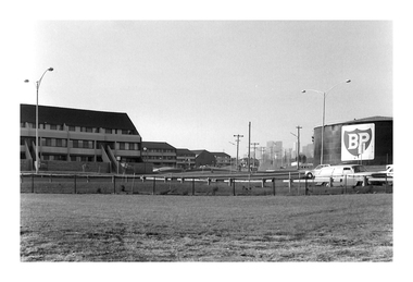
Photograph - Corner The Boulevard and Beacon Road, Andrew U'REN, C. 1970s - 1980s
From a box of photographs in Nancy U'REN's papers used during research for her thesis, The Early Growth and Development of Sandridge (1976) and/or her book with Noel TURNBULL, A History of Port Melbourne (1983). The print was probably made by her son, Andrew U'REN, and he may have also taken the photograph.Black and white photograph of the corner of The Boulevard and Beacon Road from the foreshore looking towards the city. The flats are on the left and the BP refinery site is on the right. There is a large white border at the bottom.A star in blue ink on the front. Type of photographic paper and exposure details on the reverse.built environment - domestic, the boulevard, beacon road, bp australia, nancy u'ren nee morris -
 Surrey Hills Historical Society Collection
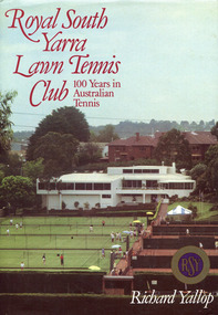
Book, Royal South Yarra Lawn Tennis Club: 100 Years in Australian Tennis, 1984
Royal South Yarra Lawn Tennis Club had its beginnings in the 1880s. The development of the club has been closely associated with the development of the game of tennis, with its changing styles of play. The Club has changed dramatically since its foundation in 1884. Tennis was a garden party pastime then and the clubhouse was a small wooden structure overlooking three asphalt courts. In the 1980s Royal South Yarra has been referred to as one of the best tennis clubs in the world. This history vividly recalls the early days of tennis and the tournaments and social events that enlivened the Club.xi, 148 p., [8] p. of col. plates : ill., facsims., ports. ; 27 cm.non-fictionRoyal South Yarra Lawn Tennis Club had its beginnings in the 1880s. The development of the club has been closely associated with the development of the game of tennis, with its changing styles of play. The Club has changed dramatically since its foundation in 1884. Tennis was a garden party pastime then and the clubhouse was a small wooden structure overlooking three asphalt courts. In the 1980s Royal South Yarra has been referred to as one of the best tennis clubs in the world. This history vividly recalls the early days of tennis and the tournaments and social events that enlivened the Club.royal south yarra lawn tennis club -- history, tennis clubs -- victoria -- south yarra -- history, richard yallop -
Glenelg Shire Council Cultural Collection
Plan - Plans/ line drawings of the layout plan for the Trawler Wharf at Port of Portland, 11/09/1988
... development. Port of Portland Front: '2' - black texta, top right ...Port of Portland layout plans for the Trawler Wharf development.Front: '2' - black texta, top right cornerport of portland