Showing 4068 items matching " surveying"
-
 Bendigo Historical Society Inc.
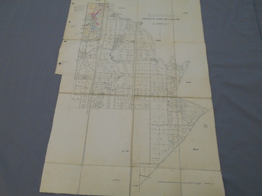
Map - JACK FLYNN COLLECTION: EDDINGTON, 1.12.1925
Map: Parish of Eddington, Counties of Gladstone and Talbot. Parish plan.Dept of Lands and Survey Melbourne by W.J. Butson 1.12.25map, talbot, parish plan, eddington, counties of talbot, gladstone -
 Bendigo Historical Society Inc.
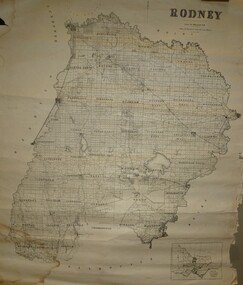
Map - JACK FLYNN COLLECTION: RODNEY, Revised in 1935
Map: County of Rodney, map sheet showing the whole of the County of Rodney and all of the Parishes within.Drawn at the Department of Lands and Survey, Melbourne. Revised to 1935map, rodney, parish plan, rodney -
 National Vietnam Veterans Museum (NVVM)
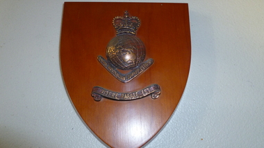
Plaque, Royal Australian Survey Corps
Wooden plaque with bronze decal of a crown atop a globe of the world on a boomerangVidere Parare Est Royal Australian Survey Corpsplaque, royal australian survey corps -
 Stawell Historical Society Inc
Map - Parish Map, Department of Lands and Survey, Ashens County of Borung 1941, 1941
Murtoa Lake MarmaPaper Brown Coloured MapDrawn and Reproduced at the department of Lands and Survey Melbourne 1.5.1941survey -
 Queenscliffe Maritime Museum
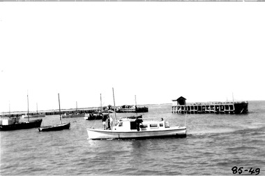
Photograph - Black & white photograph of the Ports & Harbour launch "Flinders" under way, Photographer unknown, Photographs
Photos of the Ports & Harbour launch "Flinders' at anchor.Realism, historicalBlack & white photograph of the Ports & Harbour launch "Flinders" under way at QueenscliffeOn the reverse - "P4A51 - Couta Boats and Flinders survey launch" -
 Bendigo Military Museum
Photograph - 4th Field Survey Squadron Touch Football Team, Keswick Barracks, Adelaide SA, 1987
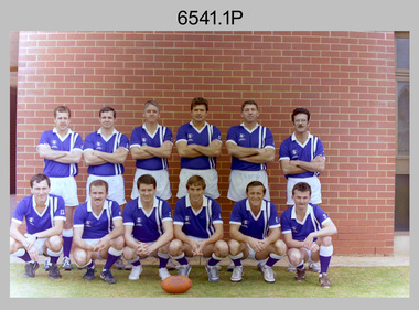
This is a set of four photographs of 4th Field Survey Squadron’s Touch Football Team possibly taken at Keswick Barracks, Adelaide SA in 1987. The competition they participated in is not known. ‘Keswick Touch Club’ text appears as part of the logo on SGT Wally Chilcott’s shirt.This is a set of four photographs of 4th Field Survey Squadron’s Touch Football Team possibly taken at Keswick Barracks, Adelaide SA in 1987. The colour photographs are on 35mm negative film and are part of the Army Survey Regiment’s Collection. The photographs were scanned at 96 dpi. .1) to .3) - Photo, colour, 1987. Back row rank L to R: SGT Peter Imeson, LCPL Peter Tuddenham, SSGT Dennis Learmonth, CAPT Danny Galbraith, CPL Roger Graf, WO2 Peter Symmans. Front row rank L to R: SPR Steve Nokes, OC MAJ Peter Cates, 2IC CAPT Terry Lord, LT Greg Oaten CSC, SGT Wally Chilcott, CPL G. Godfrey. 4) - Photo, colour, 1987. L to R: LT Greg Oaten CSC, SGT Wally Chilcott..1P to .4P – There are no personnel identified.royal australian survey corps, rasvy, 4 fd svy sqn -
 Bendigo Military Museum
Photograph - 4th Field Survey Squadron Adventurous Training, Unknown Location, SA, 1990
This is a set of seven photographs of 4th Field Survey Squadron undergoing adventurous training held at an unknown location in South Australia, in 1990. It is probable the training focussed on teamwork, leadership, field craft and living off the land survival skills. Elements from units of the Army Reserve may have participated in the training. This is a set of seven photographs of 4th Field Survey Squadron personnel undergoing adventurous training held at an unknown location in South Australia in 1990. The colour photographs are on 35mm negative film and are part of the Army Survey Regiment’s Collection. The photographs were scanned at 96 dpi. .1) - Photo, colour, 1990. Unidentified personnel. .2) & .3) - Photo, colour, 1990. L to R: unidentified, SGT John Zuringer, unidentified. .4) - Photo, colour, 1990. L to R: SPR Pat Austine, unidentified. .5) - Photo, colour, 1990. SPR Doug Willis. .6) - Photo, colour, 1990. L to R: SPR Pat Austine, SPR Doug Willis. .7) - Photo, colour, 1990. L to R: unidentified (x2), SPR Pat Austine, SGT John Zuringer, unidentified (x2)..1P to .7P – There are no personnel identified. ‘1990 ADV TRAINING’ annotated on negatives sleeve.royal australian survey corps, rasvy, 4 fd svy sqn -
 Bendigo Military Museum
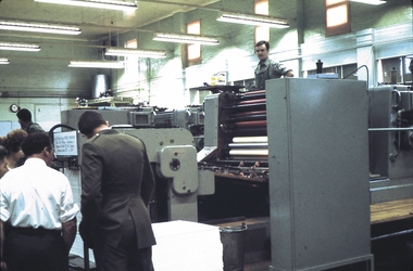
Photograph - Wayzgoose Hall and Speedmaster Printing Press Commissioning, Army Survey Regiment, Fortuna Villa, Bendigo, 1990
The first photograph was probably taken at a media event announcing the introduction of the Heidelberg Speedmaster printing press in late 1990. LTCOL Rene van den Tol was the CO of the Army Survey Regiment from 1989 to 1991. Partly obscured behind the CO was Mr Bruce Reid, who was the newly elected federal member for Bendigo. The media event was held in Wayzgoose Hall, Lithographic Squadron’s new purpose-built building constructed to house the Speedmaster printing press. This occasion is covered in more detail in page 143 of Valerie Lovejoy’s book 'Mapmakers of Fortuna – A history of the Army Survey Regiment’ ISBN: 0-646-42120-4. Refer to Item 6291.6P for more photos of the Open Day.This set of three photographs were taken at the commissioning ceremony of Wayzgoose Hall, the Army Survey Regiment’s new printing building and the Heidelberg Speedmaster Printing Press, at Fortuna Bendigo on Wednesday 27th June 1990. The black & white photographs were printed on photographic paper and are part of the Army Survey Regiment’s Collection. The photographs were scanned at 300 dpi. .1) - Photo, black & white, 1990. Commissioning Ceremony L to R: CO LTCOL Rene van den Tol, Commander 3rd Military District BRIG P. Davies AM ADC, WO2 Jeff Willey in background. .2) - Photo, black & white, 1990. L to R: CO LTCOL Rene van den Tol, Commander 3rd Military District BRIG P. Davies AM ADC with first printed topographic map – 8123 4 Mansfield 1:50 000. .3) - Photo, black & white, 1990. L to R: SGT Gary Kerr in background, Seligson Claire Printing Press Suppliers - Richard Rasmussen and Oliver Holliwell, Bob Martin, Director of Survey COL Don Swiney MBE, RA Svy COL CMDT COL John Hillier, Commander 3rd Military District BRIG P. Davies AM ADC, Bruce Reid Bendigo MHR..1P to .3P – Annotated on back of photos ‘Opening New Print Room BRIG Davies 27 Jun 90’. Personnel and civilians are identified.royal australian survey corps, rasvy, army survey regiment, army svy regt, fortuna, asr, litho -
 Federation University Historical Collection
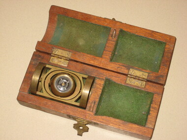
Instrument - Scientific Instrument, Pajari Instruments, Boxed Tropari
This item was most probably used at the Ballarat School of Mines. Pajari Instruments Ltd. grew from a partnership established in 1945 when the first EX-AX surveying instrument that provided accurate azimuth and inclination was made available to the diamond drilling industry. The partnership between Charles Trotter and George Pajari Sr. was known as Trotter-Pajari Instruments and the EX-AX Instrument was dubbed the "TROPARI" by the diamond drilling industry. Charles Trotter, a mechanical engineer, was also a marketing genius who developed substantial demand in Australia, Africa and South America in the 1940's and early 1950's. In fact the sales to each of these continents exceeded those to North America during those early years. Pajari is located in Orillia, Ontario, Canada and offer services and products that assist customers with their individual requirements. After the death of Charles Trotter in 1956, George Pajari Sr. with the assistance of his wife Hilda continued the business under the title of Pajari Instruments. George Sr. set most of the tenets that comprise our present Mission Statement. If it wasn't user friendly or if it had to have experts to operate it, that instrument design was doomed. If the customer wasn't getting good value in his opinion, manufacturing and repair procedures were examined to see where efficiency could be improved to cut costs without sacrificing Quality. George Pajari Jr and his wife Darlene assumed the reins of Pajari Instruments Ltd. in 1981 when George Sr. decided on semi-retirement. George Jr. brought the "client geologist's" perspective to the company. The company moved from Toronto to a 30 hectare (80 acre) site near Orillia shortly afterward. This site provided the high magnetic latitude earth field environment without magnetic pollution that is necessary for accurate compass setting. The park like setting of this location is a positive psychological benefit for our staff. George Sr. passed away in 2002 being preceded by Hilda only by 3 months, George Jr. continues at the helm of the company. With dedication from long term employees/contractors and third generation family members, Pajari Instruments Ltd. continues operations/new product development in Orillia. (http://www.pajari.com/about.html) Brass levelling compass in green velvet lined hinged timber box. Known as a Tropari - a single-shot, micro-mechanical borehole surveying instrument operated by a timing device. Borehole direction is measured from the earth's magnetic field. The Tropari provides both direction and inclination which can be used to define the attitude of the borehole at the survey depth. Regular surveys at intervals as the borehole progresses will allow a plot of the borehole to be drawn from the data. The Tropari is easy to use and maximizes profits by minimizing capital and operational costs. The Basic Survey Train Consists of: PDSI / Tropari Container, 6m (20 ft) Nonmagnetic Rods, Impact Foot, and Connector at Top. (http://www.pajari.com/tropari.html) A sticker on the lid of the hinged box states: "A.E. Parsons 107 Leicester St., Carlton 3053 Telephone 347 5844"scientific instrument, compass -
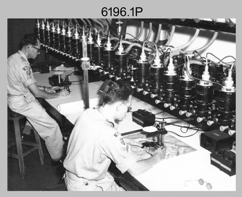 Bendigo Military Museum
Photograph - Multiplex mechanical stereoplotting equipment, Army Survey Regiment, Fortuna Bendigo, c1950s
This is a set of five photographs of Multiplex mechanical stereoplotting equipment at the Army Survey Regiment, Fortuna Bendigo. c1950s. Multiplex equipment was imported from the UK in 1951 and introduced in the following year, to accelerate map production output covering CMF training areas at 1:25,000 map scale. Multiplex plotting was a productive advancement replacing the ‘Arundel’ method of graphical plotting planimetric detail that was expensive and slow, especially in timbered mountainous terrain. Air photos were made into small diapositives and mounted on racks in the exact position relative to when the aerial photos were taken. The technicians operated the Multiplex in a darkened room, with one photo projected with a green filter and the other through a red filter to form a 3D view of the overlapping photos. The 3D model projected onto a platen, which was a small platform that was raised up and down. The technician viewed the 3D image with special glasses fitted with red and green lenses. In the centre of the platen was a small pinhole that served as a floating mark, with a vertical pencil located exactly below the pinhole. This tracing table was moved to follow the topographic feature or contour line and draw it on the paper underneath. The technician raising or lowering the platform’s floating mark to match the height of the 3D terrain. It also replaced the slotted template method of mechanical adjustment of strips of aerial photography, however was restricted to each strip rather than between strips in the block. Although the Multiplex was phased out of production in 1968, it was used in the training of photogrammetry and aero-triangulation at the School of Military Survey located at Bonegilla, Victoria until the early 1990s. The history of the Multiplex is covered in more detail with additional historic photographs, in pages 50 to 51 of Valerie Lovejoy’s book 'Mapmakers of Fortuna – A history of the Army Survey Regiment’ ISBN: 0-646-42120-4.This is a set of five photographs of Multiplex mechanical stereoplotting equipment at the Army Survey Regiment, Fortuna, Bendigo. c1950s. The photographs were printed on photographic paper and are part of the Army Survey Regiment’s Collection. The photographs were scanned at 300 dpi. .1) - Photo, black & white, c1950s, unidentified personnel operating Multiplex equipment. .2) - Photo, black & white, c1950s, Multiplex equipment. .3) - Photo, black & white, c1950s, Multiplex components identified. .4) - Photo, black & white, c1950s, Multiplex optical components. .5) - Photo, black & white, c1950s. Unidentified technician laying down individual Multiplex plots..1P to .2P, .4P – No annotations. .3P annotations identifying Multiplex components on front of photo. .5P annotated on front ‘Lay down of individual Multiplex plots at 1/14000 to framework of master grid to form Composite Compilation Sheet – Material Duralex.’royal australian survey corps, rasvy, army survey regiment, army svy regt, fortuna, asr, photogrammetry -
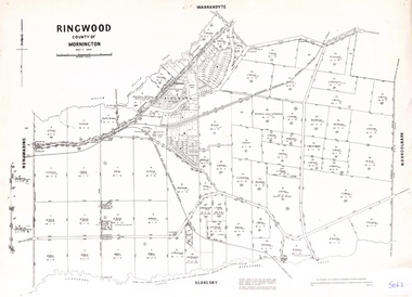 Ringwood and District Historical Society
Map - Parish of Ringwood, County of Mornington, Victoria, Original Land Owners
Laminated Parish map of Ringwood detailing original Land Owners' names, property locations and acreages. Details reproduced in 1957 by the Department of Lands and Survey, Melbourne, from original surveys of varying dates. -
 Otway Districts Historical Society
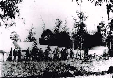
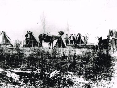
Photograph, Knox Collection, Survey camp for Colac-Beech Forest railway, 1901, 1901
Plans for a rail connection between Colac and Beech Forest had been drawn up in 1884 and 1889 but proofed inconclusive because of the enormous cost involved in building a railway in such difficult terrain. Because of the financial depression in the early 1890s such expenditure went of hold. Towards the end of the decade planners recognised that a narrow gauge could be a viable alternative and it was taken up by the community, Parliamentary representatives and the government, although Victorian Railways administration was against the idea. This was overridden. The 1898 Parliament approved a 2 foot 6 inch gauge from Colac to Beech Forest although strict financial limits were set. The route was to be the most direct and the infrastructure the most basic. Construction began in 1900 entailing very steep grades and myriad curves until it finished in 1902. Surveyors and their assistants came before and during the track laying for the whole distance.B/W. Survey camp for the Colac-Beech Forest railway in 1901, showing nine tents, ten men including a cook, survey instruments, and three bicycles. Note the cooking fire on the right.colac: beech forest; railways; survey; -
 University of Melbourne, Burnley Campus Archives
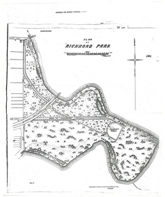
Plan - Photocopy, A.L. Martin et al, Plan of Richmond Park, 1872
Layout of Richmond Park showing railway line, Pic-Nic Station, Swan Street extension and Horticultural Society's Garden. 3 photocopies of plan surveyed and drawn by A.L. Martin, Authorised Surveyor. Photolithographed at Dept of Lands and Survey by J. Noone 6th Sept. 1872. Showing the entire park and the Horticultural Society's Garden.richmond, parks, a.l. martin -
 Bendigo Military Museum
Photograph - Subject 1 Corporal course Awards, Army Survey Regiment, Fortuna Villa Bendigo, 1987
This is a set of 20 photographs of two personnel with their training awards upon return from their Subject 1 Corporal course, taken at the Army Survey Regiment, Bendigo in October 1987. Lithographic Squadron’s SPR Janet Murray and SPR Shona Hastie achievement on a military skills-based promotion course was commendable, given most of their employment was spent in Royal Australian Survey Corps technical tasks.This is a set of 20 photographs of two personnel with their training awards upon return from their Subject 1 Corporal course, taken at the Army Survey Regiment, Bendigo in October 1987. The photographs are on 35mm negative film and were scanned at 96 dpi. They are part of the Army Survey Regiment’s Collection. .1) to .4) - Photo, black & white, 1987, SPR Shona Hastie with her SUBJ 1 CPL course award. .5) to .10) - Photo, black & white, 1987, SPR Janet Murray with her SUBJ 1 CPL course award. .11) - Photo, black & white, 1987, L to R: SPR Shona Hastie and SPR Janet Murray with their SUBJ 1 CPL course awards. .12) to .14) - Photo, black & white, 1987, L to R: SPR Janet Murray and SPR Shona Hastie with their SUBJ 1 CPL course awards. .15) to .17) - Photo, black & white, 1987, SPR Janet Murray with her SUBJ 1 CPL course award in front of an Ultra-MAN-III printing press. .18) to .20) - Photo, black & white, 1987, SPR Shona Hastie with her SUBJ 1 CPL course award in front of the Pakotone film processor..1P to .20P – ‘SPR Murray & Hastie SUBJ 1 for CPL Awards Oct 87’. royal australian survey corps, rasvy, army survey regiment, army svy regt, fortuna, asr, litho -
 Federation University Historical Collection
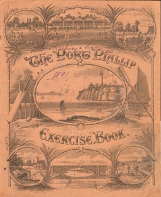
Booklet, The Port Phillip Exercise Book, 1891
An exercise book with illustrated cover containing lecture notes on machinery and surveying. ballarat school of mines, machinery and surveying, lighthouse, cricket, bridge -
Federation University Historical Collection
Book, Ballarat Performing Arts: A Facilities Usage Survey, 1986
A usage survey for Ballarat performing arts published by the Victorian Ministry for the Arts.victorian ministry for the arts, performing arts, courthouse theatre, her majestys, theatres, memorial theatre, founder hall, mt clear technical school, civic hall, victorian theatre sovereign hill -
 Running Rabbits Military Museum operated by the Upwey Belgrave RSL Sub Branch
Photograph
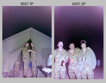
Photo Collage of Nui Dat Vietnam, by Royal Australian Survey Corpsphoto, 1967, army -
 Bendigo Historical Society Inc.
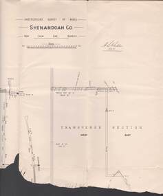
Map - STRUGNELL COLLECTION: UNDERGROUND SURVEY OF MINES, BENDIGO, 20-3-01
Map, Underground Survey of Mines, Bendigo.Shenandoah Co., New Chum Line,H.S.Whitelawmap, bendigo, shenandoah co. -
 Bendigo Historical Society Inc.
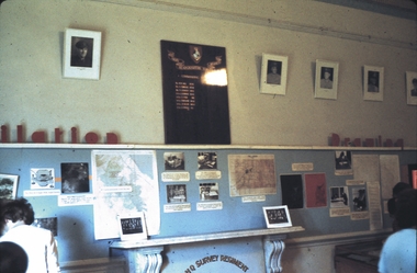
Slide - AHQ,SURVEY REGT, FORTUNA,BENDIGO, April 1970
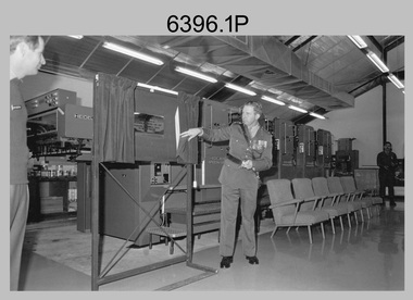
Slide. AHQ, Survey Regt, Fortuna, Bendigo. Information area at Fortuna.slide, bendigo, ahq, survey regt, fortuna, bendigo., ahq, survey regt, fortuna, bendigo. -
 Bendigo Historical Society Inc.
Slide - AHQ,SURVEY REGT, FORTUNA,BENDIGO, April 1970
Slide.AHQ, Survey Regt, Fortuna, Bendigo. Visitors looking as a worker works.slide, bendigo, ahq, survey regt, fortuna, bendigo., ahq, survey regt, fortuna, bendigo. -
Whitehorse Historical Society Inc.
Document, Wandinong Floristic survey, 1993
A survey and management prescriptions for the enhancement of indigenous vegetation and the control of weed species.A survey and management prescriptions for the enhancement of indigenous vegetation and the control of weed species.A survey and management prescriptions for the enhancement of indigenous vegetation and the control of weed species.wandinong sanctuary, native plants, weeds -
 Otway Districts Historical Society
Photograph, Railway survey camp, c.1901, c.1901
Six surveyors and a horse posing outside five tents somewhere on the Beech Forest line in approximately 1901.Photograph, B/W. Railway survey camp, Beech Forest line.survey camp; beech forest; railways; -
Canterbury History Group
Document - School Project: Elgar's Special Survey, Tudehope, Jennifer, 1963
Well researched essay on the background of Elgar's Special Survey. Includes mapcanterbury, elgar> henry t., land surveys, boroondara, campbell> j & r, dacre> r, towns> r., sea> h., dyce> a., mccarthy> w.g., shenley> james, henty's paddock, norris> j.r., maling> j, canterbury road, survey road, boroondara roads board, camberwell historical society, mont albert road, brooks> r., land subdivisions -
 Whitehorse Historical Society Inc.
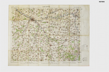
Map - Amiens France Map from collection of C H Honybun, Amiens, 1916
WW1 Topograhical Map of Amiens Region, France (Allied) 1915Printed map, France 1:100,000 Ordnance Survey, Oct 1915non-fictionWW1 Topograhical Map of Amiens Region, France (Allied) 1915world war 1914 - 1918, ameins -
 Bendigo Military Museum
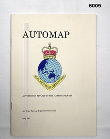
Pamphlet - AUTOMAP - Automation Applied to the Mapping Process, Major Sam Thompson US Army Corps of Engineers, 01.07.1977
This pamphlet produced by Major Sam Thompson US Army Engineer Corps on exchange to Australia was published as a guide to AUTOMAP 1, the Army Survey Regiment’s first computer-based map production system. It examined how automation had changed the compilation and drafting phases of the map production process. It attempted to present in a light-hearty story telling style, short and clear description of each AUTOMAP 1 sub-system with photos of staff and equipment, diagrams and humorous cartoons. The cartoonist is unknown. The pamphlet was printed at the Army Survey Regiment, Bendigo Army Survey Regiment pamphlet comprises a manilla card cover printed in colour with 24 pages with photographs in black and white; and descriptions, diagrams, and cartoons printed in colour. It is bounded by two staples on its spine. The coloured pages have been scanned at 300 dpi and are stored on a USB Digital Storage Device. The page images have been converted into a video (.mp4) format and also stored on the USB. The video is 1.3Mb in size and runs for 1.3 minutes.royal australian survey corps, rasvy, fortuna, army survey regiment, army svy regt, asr -
 Bendigo Historical Society Inc.
Document - LANDS OFFICE, CROWN LANDS SURVEYED AND SOLD, 1860/70
Document: buff hard cover journal, embossed on borders. On spine 'Lands and Survey' 'Index Book' and '03'. Contains list of parishes in front cover, indexed to page numbers which describes land surveyed and sold in parishes. Double page entries. 230 pages in book. LH page ' town lands, suburban lands, country lands, total lands surveyed, date of survey. RH page: date of sale, by auction, by selection, price per acre, total amount name of purchaser.Lands Officeland sales, lands office, land surveyed, land sold, bendigo, sandhurst -
 Melbourne Tram Museum
Document - Notice, The Met, Public Transport Corporation, "Joint Union/Management Staff Survey", "Summary of Surveys undertaken in the PTC", early 1990's
.1 - Notice - A4 sheet - titled "Joint Union/Management Staff Survey", not dated, detailing the scope of a survey to be undertaken by the PTC asking information about the feeling for important issues. Has the term "Service Now" in the bottom right hand corner. .2 - A4 Sheet titled "Summary of Surveys undertaken in the PTC", detailing 5 surveys between 1985 and 1990, giving purpose, purpose and benefits - included staff attitudes, equal employment opportunity, consultation, clerical and smoking.trams, tramways, surveys, smoking, ptc, staff, unions, employment -
 Federation University Historical Collection
Plan - Contour tracings, Ballarat University College residence carparks and detail survey of Mt Helen campus, 1991/1992
3 ink on tracing paper survey maps .1) Detail survey Mt Helen campus 1992 .2) Top residence car park 1991 .3) BUC residences' car park 1991ink on tracing paper, b.u.c surveys, transpotr, ballarat college of advanced education, mount helen campus, carpark, student residences -
 National Vietnam Veterans Museum (NVVM)
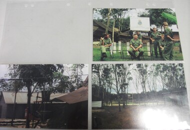
Photograph
Three Colour Photograph taken in Vietnam 1. Seven Khaki clad men in front of sign Royal Australian Survey Corps 1st Topographical Survey Troop 2+3. Scenes of building and treesphotograph, royal australian survey corps -
 Bendigo Historical Society Inc.
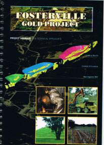
Document - FOSTERVILLE GOLD MINE COLLECTION: PROJECT UPGRADE TECHNICAL APPENDICES
Black cover book, wire binding. Pages in reports numbered individually, overall approx 250 page report. On front: "Fosterville Gold Project' Project upgrade, EES Technical Appendix B. Central North, Central Ellesmere, Harringtons Hill." Page 1 'Perseverance Exploration Pty Limited' Book contains technical appendices. Topics: hydro geological assessment; surface drainage study, noise emission to residential properties, flora survey, tailings dam site; flora survey Wellesford Forest; Daley's Hill Plant List; diurnal Avifauna Survey - Wellesford Forest; survey of vertebrate fauna - Wellesford Forest; brief summary of fauna - Daley's Hill, Axedale, Aboriginal Archaeological survey; archaeological investigation Fosterville; traffic survey - Fosterville Sulphide Project; traffic report.bendigo, mining, fosterville gold mine