Showing 762 items
matching aerial views
-
 Port Melbourne Historical & Preservation Society
Photograph - Aerial view of (finally) in-filled Lagoon, Port Melbourne, 1931
... Aerial view of (finally) in-filled Lagoon, Port Melbourne... Street) Port Melbourne melbourne Aerial view of (finally ...Image seems to be one of several aerial shots around 1931, possibly all shot from one flight. Aerial photo of Port Melbourne c1931 showing clearly the finally filled Lagoon, and central area from Gasworks to past Bay Street, from Town Hall to Town Pier. Cable tram cars can be seen on Bay Streetsandridge lagoon, built environment -
Port Melbourne Historical & Preservation Society
Photograph - Aerial view of Port Melbourne, circa 1928
... Aerial view of Port Melbourne... Street) Port Melbourne melbourne Aerial view of Port Melbourne ...Aerial photo of Port Melbourne c1928 focusing on the Gas Works area spanning Port Melbourne and Albert Park. Shows the finally filled Lagoon, and area from the Harpers Starch factory to Foote St, Albert Park and from the bay to just over Richardson/Liardet Stssandridge lagoon, built environment - industrial, industry, gasworks, joshua brothers distillery, harpers starch factory -
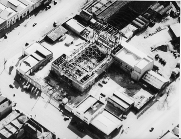 Ballaarat Mechanics' Institute (BMI Ballarat)
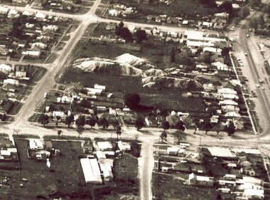
Aerial view buiding of Civic Hall 1960's
... Aerial view buiding of Civic Hall 1960's... Ballarat goldfields Aerial view buiding of Civic Hall 1960's ...This photograph is from the Max Harris Collection held by the Ballaraat Mechanics' Institute. Please contact BMI for all print and usage inquiries.ballarat, aerial, construction, civic hall, 1960s, doveton, armstrong, mair -
 Ballaarat Mechanics' Institute (BMI Ballarat)
Aerial view of Bridge Mall & Bakery Hill, Max Harris
... Aerial view of Bridge Mall & Bakery Hill... Ballarat goldfields Aerial view of Bridge Mall & Bakery Hill ...This photograph is from the Max Harris Collection held by the Ballaraat Mechanics' Institute. Please contact BMI for all print and usage inquiries.ballarat, bridge mall, bakery hill, 1980s, aerial -
 Ballaarat Mechanics' Institute (BMI Ballarat)
Aerial view of Bridge Mall area, Max Harris
... Aerial view of Bridge Mall area... Ballarat goldfields Aerial view of Bridge Mall area This photograph ...This photograph is from the Max Harris Collection held by the Ballaraat Mechanics' Institute. Please contact BMI for all print and usage inquiries.ballarat, bridge mall, bakery hill, 1980s, aerial -
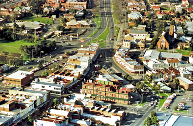
 Ballaarat Mechanics' Institute (BMI Ballarat)
Aerial view looking south over Ballarat
... Aerial view looking south over Ballarat... Ballarat goldfields Aerial view looking south over Ballarat ...ballarat, lydiart st, sturt st, armstrong st, aerial, view, above -
 Ballaarat Mechanics' Institute (BMI Ballarat)
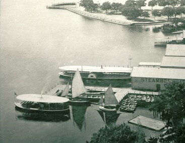
Aerial view lake and steamers
... Aerial view lake and steamers... Ballarat goldfields Aerial view lake and steamers This photograph ...This photograph is from the Max Harris Collection held by the Ballaraat Mechanics' Institute. Please contact BMI for all print and usage inquiries.ballarat, lake wendouree, aerial, steamers -
 Churchill Island Heritage Farm
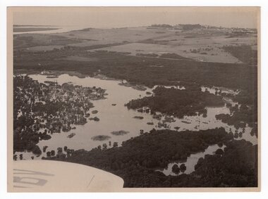
Aerial view of estuary, Unknown
... Aerial view of estuary... Churchill Island Churchill Island gippsland Aerial view of estuary ...Churchill Island Heritage Farm has a large photograph collection dating from the mid-nineteenth century to the last decade. This series of photographs show events and people from the Churchill Island precinct and the enormous amount of collaboration and work that went into the development of the heritage area and making it accessible and interactive for visitors of all ages. Black and white aerial photograph of estuary. Plane wing is visible in bottom left corner. White border.Catalogue number in pencil on reverse. "EJ4/29" on reverse in pencilchurchill island, aerial photography, estuary -
 Eltham District Historical Society Inc
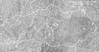
Work on paper (Sub-Item) - Photograph, St Helena East, St Helena West and Eltham West drains, ca 1980
... aerial view... Helena drains aerial view ...black and white aerial photograph with boundary and drains marked over three page fold out eltham, st helena, drains, aerial view -
 Eltham District Historical Society Inc
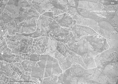
Work on paper (Sub-Item) - Photograph, Research Creek
... aerial view... and Main Road highlighted. eltham research aerial view Research ...Black and White aerial photograph of Research witht the Research Creek and Main Road highlighted.eltham, research, aerial view, research creek -
 Eltham District Historical Society Inc
Photograph - Aerial Photograph, Landata, Eltham and Lower Plenty, Nov. 1931
Centred over present-day Rosehill Road and View Road, Lower Plenty Historic Aerial Imagery Source: Landata.vic.gov.au Aerial Photo Details: Project No :1931 Project : MALDON PRISON Run : 19 Frame : 3129 Date : 11/1931 Film Type : B/W Camera : F8 Flying Height : 11000 Scale : 18860 Film Number : 60 GDA2020 : 37°44'16"S, 145°07'40"E MGA2020 : 335039, 5821622 (55) Melways : 21 E11 (ed. 42)aerial photo, eltham, lower plenty, neil webster collection, rosehill road, view road -
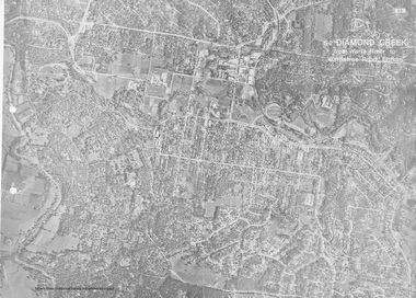 Eltham District Historical Society Inc
Work on paper (Sub-Item) - Aerial Photograph, Diamond Creek from Yarra River to Wattletree Road, Eltham
... aerial view... aerial view Eltham Eltham North ...Black and white aerial photograph witrh key features around the central place of Eltham township marked inluding Yarra River, Main Road, Bridge Street and Ryans Road, Eltham North land development, real estate, aerial view, eltham, eltham north -
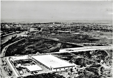
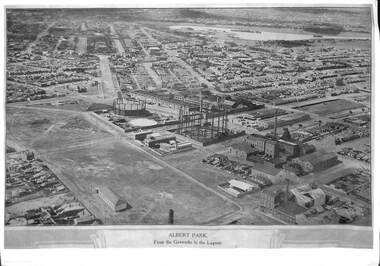 Port Melbourne Historical & Preservation Society
Photograph, E C Joshua, Albert Park from the Gasworks to the Lagoon, 1921
Rare copy of E C JOSHUA and Captain LARKIN work."Albert Park from the Gasworks to the Lagoon" Copy of aerial photography 1921 of former lagoon area taken by E C JOSHUA (photographer) and Captain H J LARKIN (pilot). "Views from an Aeroplane" black and white copy. Plus separate sheet giving brief description of photographtransport - aviation and aerodrome, sandridge lagoon, natural environment, recreation, built environment, parks and gardens, e c joshua, h j larkins, gasworks, schumaker mill furnishing works, pump house, sugar shed, joshua bros distillery -
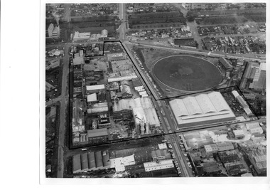 Port Melbourne Historical & Preservation Society
Photograph - Aerial view of J Kitchen & Sons site, Port Melbourne
... Aerial view of J Kitchen & Sons site, Port Melbourne... Street) Port Melbourne melbourne Aerial view of J Kitchen & Sons ...The source of the images is unknown. The date has been estimated in reference to catalogue items 2989 (approx 1945) and 2990 (approx 1970) - both aerial photos of the area.Two black and white aerial photos of J Kitchen & Sons factory prrecinct, approximately 1960s. .01- Looking towards the East with Ingles St in the centre and Port Melbourne cricket/football ground on the right. Rail line is at the top. The Kitchen property is outlined. .02 - Looking towards the North with Port Melbourne cricket/football ground at the bottom, Kitchens (outlined) in the centre and other industrial to the North.built environment - industrial, industry - manufacturing, sport - australian rules football, business and traders - soaps/candles, j kitchen & sons pty ltd, port melbourne football and cricket ground, north port oval -
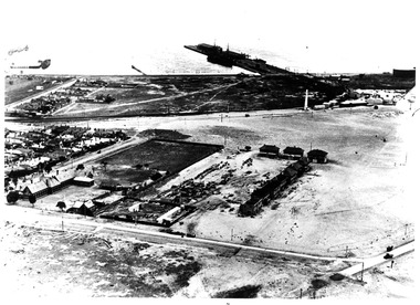
 Port Melbourne Historical & Preservation Society
Photograph - Aerial view of Fisherman's Bend circa 1940, circa1940
... Aerial view of Fisherman's Bend circa 1940.... Street) Port Melbourne melbourne Aerial view of Fisherman's Bend ...From the collection of Terry KEENAN. The 9 hole golf course known as the Sandridge Golf Club was part of Victorian Golf Clubs until it moved to Cheltenham in 1927. Trotting 'Speedway' located at top right of photograph.Black and white photograph of Fishermans Bend, Port Melbourne, c. 1940 showing General Motors Holden in the foreground. The original home of the Victoria Golf Club is shown on the left beside the Yarra River winding towards the city & North & South Wharves. built environment, fishermans bend, built environment - industrial, general motors-holden, victoria golf club, sport - golf, sport - horse racing -
 Port Melbourne Historical & Preservation Society
Photograph - Aerial view of first Bank Houses in Garden City, 1927
... Aerial view of first Bank Houses in Garden City... Street) Port Melbourne melbourne Aerial view of first Bank Houses ...Photographic copies from black and white aerial photograph of the building of the first State Savings Bank Houses in Garden City 1927, showing also Graham Street State School, Princes Pier, Graham Street and Williamstown Road, west wing of Station Pier ("Rotomahana" at pier)built environment - domestic, fishermans bend, garden city, education - primary schools, melbourne harbor trust - port of melbourne authority, state savings bank of victoria, graham street state school, port melbourne primary school, bank houses -
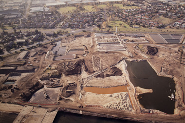 Port Melbourne Historical & Preservation Society
Photograph - Aerial view Beacon Cove area during soil cleaning operation, 1990
... Aerial view Beacon Cove area during soil cleaning operation... Street) Port Melbourne melbourne Aerial view Beacon Cove area ...Framed colour aerial photograph of the Beacon Cove area during the soil cleaning operation prior to building the project. Area covered: from Beacon Road to Bain Street, and from the beach to the rear beacon. Foot of Princes Pier also shown.environmental issues -
 Ballaarat Mechanics' Institute (BMI Ballarat)
Aerial View
... Aerial View... Ballarat goldfields Aerial View This photograph is from the Max ...This photograph is from the Max Harris Collection held by the Ballaraat Mechanics' Institute. Please contact BMI for all print and usage inquiries.ballarat, aerial, 1960s -
 Ballaarat Mechanics' Institute (BMI Ballarat)
Aerial View Guiding Court vicinity
... Aerial View Guiding Court vicinity... Ballarat goldfields Aerial View Guiding Court vicinity ...This photograph is from the Max Harris Collection held by the Ballaraat Mechanics' Institute. Please contact BMI for all print and usage inquiries. ballarat, aerial, 1960s -
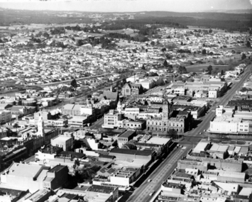
 Ballaarat Mechanics' Institute (BMI Ballarat)
Aerial View Ballarat Southern CBD
... Aerial View Ballarat Southern CBD... Ballarat goldfields Aerial View Ballarat Southern CBD ...This photograph is from the Max Harris Collection held by the Ballaraat Mechanics' Institute. Please contact BMI for all print and usage inquiries.ballarat, aerial, 1960s -
Port Melbourne Historical & Preservation Society
Photograph - aerial view of Port Melbourne, 1942
... aerial view of Port Melbourne... Street) Port Melbourne melbourne aerial view of Port Melbourne ...The Mathews family have been in continuous ownership of 395 Howe Parade (was 8 Howe Parade until 1964 when addresses re-assigned), Port Melbourne from 1938 to the present (Sept 2019)Six folders of assorted documents relating to the life of Alan Mathews and his family. Employment documents. Folder 6 has photographs. Two photocopies of aerial photos of Port Melbourne. Copy 1 has Howe Parade; C.O.R. tanks; Engine Works; First Point and piers markeddomestic life, alan mathews -
Port Melbourne Historical & Preservation Society
Photograph - Aerial view of Port Melbourne, 23 Dec 1945
... Aerial view of Port Melbourne... Street) Port Melbourne melbourne Aerial view of Port Melbourne ...One of three prints of aerial photographs of Port Melbourne 23.12.1945, showing different areas and to different scales: this one vertical, takes in Station and Town Piers, railyards, Missions to Seamen, Engine Works, temporary US wartime structures, edge of COR buildings, Swallow & Ariell, portion of Wiilliamstown Road. (Smaller copies located in A.06.04.B4)piers and wharves - station pier, piers and wharves - town pier, war - world war ii, built environment, transport - railways, missions to seamen, swallow & ariell ltd -
Port Melbourne Historical & Preservation Society
Photograph - Aerial view of Port Melbourne piers and foreshore, Jack GOULD
... Aerial view of Port Melbourne piers and foreshore.... Street) Port Melbourne melbourne Aerial view of Port Melbourne ...From a box of photographs in Nancy U'REN's papers used during research for her thesis, The Early Growth and Development of Sandridge (1976) and/or her book with Noel TURNBULL, A History of Port Melbourne (1983). Jack GOULD probably created this from an earlier photograph.Black and white aerial photograph showing the Port Melbourne foreshore and the piers from Princes Pier to Lagoon Pier and beyond. C. 1922-23.piers and wharves - princes pier, piers and wharves - town pier, piers and wharves - lagoon pier, foreshore, piers and wharves - railway pier, nancy u'ren nee morris -
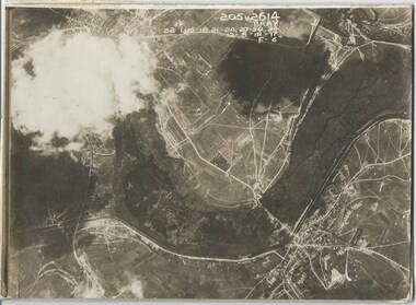
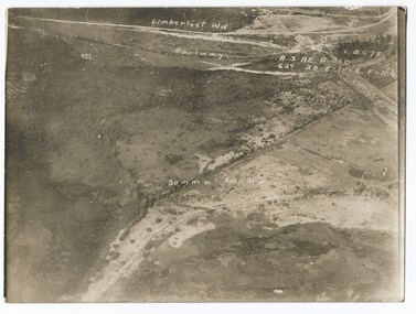 Melbourne Legacy
Photograph - Photo, Aerial view of the Somme
... Aerial view of the Somme... Photo Photograph Aerial view of the Somme Sepia photo ...An aerial photo of the Somme Swamp in France during World War One. There are coordinates or numbers in some areas. Also labelled are the railway line and Canal du Nor and Limberlost Wood. Was with 11 other photos of World War One that had been mounted on board for display at Legacy House at some stage. When they were taken off display they were put in the archive cabinets. The founding legatees all served in World War One so these photos would have been of significant places for them. (see 01888 to 01899)Photos from World War One that would have been significant to the founding legatees.Sepia photo of the Somme battlefield in France during World War One.world war one, france, somme -
 Melbourne Legacy
Photograph - Photo, Aerial view of the Somme
... Aerial view of the Somme... Photo Photograph Aerial view of the Somme Sepia photo ...An aerial photo of the Somme Swamp in France during World War One. There are coordinates or numbers in some areas. Was with 11 other photos of World War One that had been mounted on board for display at Legacy House at some stage. When they were taken off display they were put in the archive cabinets. The founding legatees all served in World War One so these photos would have been of significant places for them. (see 01888 to 01899)Photos from World War One that would have been significant to the founding legatees.Sepia photo of the Somme battlefield in France during World War One.world war one, france, somme -
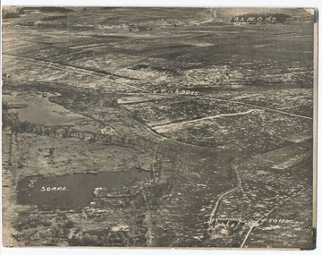
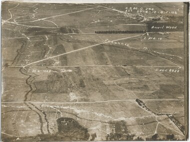 Melbourne Legacy
Photograph - Photo, Aerial view of the Somme
... Aerial view of the Somme... Photo Photograph Aerial view of the Somme Sepia photo ...An aerial photo of the Somme in France during World War One. There are coordinates or numbers in some areas. Also labelled are the Johannes and Anvil Wood. Was with 11 other photos of World War One that had been mounted on board for display at Legacy House at some stage. When they were taken off display they were put in the archive cabinets. The founding legatees all served in World War One so these photos would have been of significant places for them. (see 01888 to 01899). From the AWM: Anvil Wood was a small wood to the north of Peronne that marked the centreline of an attack by the 14th Brigade on the morning of 1 September 1918. The northern approaches to Peronne were covered by numerous field and machine-guns, but the leading battalions of the brigade - the 53rd and 54th - pushed their attack home with determination, and sent the German defenders fleeing back to Peronne. The attack opened the way for the 14th Brigade to advance on to Peronne itself and break into the town's northern defences.Photos from World War One that would have been significant to the founding legatees.Sepia photo of the Somme battlefield in France during World War One.world war one, france, somme -
 Melbourne Legacy
Photograph - Photo, Aerial view of the Somme
... Aerial view of the Somme... Photo Photograph Aerial view of the Somme Sepia photo ...An aerial photo of the Somme in France during World War One. There are coordinates or numbers in some areas. Also labelled is Bray. Was with 11 other photos of World War One that had been mounted on board for display at Legacy House at some stage. When they were taken off display they were put in the archive cabinets. The founding legatees all served in World War One so these photos would have been of significant places for them. (see 01888 to 01899)Photos from World War One that would have been significant to the founding legatees.Sepia photo of the Somme battlefield in France during World War One.world war one, france, somme -
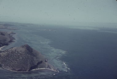 Ballarat Heritage Services
Slide, Dorothy Wickham, Port Moresby, Papua New Guinea, 1958
This photograph was taken around 1958.Scanned from a coloured slideView from this sidepapua new guinea, papuans, port moresby, aerial -
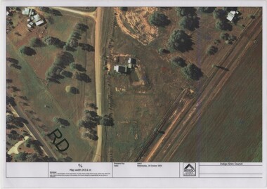 Rutherglen Historical Society
Image, Indigo Shire Council, 28/10/2009
When operational, the Gold Battery used cyanide in its processing processes. The land surrounding it required remediation before it could be handed over to Indigo Shire for public use. The land has since been planted with pasture and native plants. The Gold Battery has been restored to working condition, and can be viewed by collecting a ticket from the Rutherglen Wine Experience and Visitor Information Centre.Laminated aerial photograph of Gold Battery site, believed taken before land remediation.gold battery, gold processing -
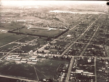
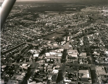
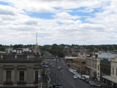 Ballarat Heritage Services
Photograph - Photograph - Colour, Ballarat From the Regent Cinema, Lydiard Street North, Ballarat, 2015, 27/12/2016
Lydiard Street is known as an axcellent example of Victorian architecture.Various views of Ballarat's Lydiard Street Northballarat, lydiard street north, buildings, aerial, birds eye, sebastions, regent cinema