Showing 576 items
matching ballarat east gardens
-
 Ballarat Tramway Museum
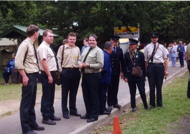
Photograph - Colour Photograph/s, Carolyn Dean, Mar. 1999
Set of 23 photographs taken by Carolyn Dean between 6/3/1999 and 16/4/1999 of the Begonia Festival operations and moving the ex SEC bike shed to Bungaree. On Kodak paper. 1094.1 - Group of tramway staff at Gardens Loop - used in May 1999 Fares Please! .2 - tram 40 at loop .3 - sign boards used in 1999 Begonia festival .4 - Welding joint 2-3 road - Warren Doubleday and Gary Wood .5 - ditto with Alastair Reither .6 - Fixing fence at Bungaree - John Phillips .7 - ditto .8 - ditto .9 - site for the hut to go at Bungaree .10 - ditto .11 - treated pine posts for stumps .12 - checking the layout - John Phillips .13 - cutting fire wood .14 - trimming trees .15 - Dismantling the roof on the shed at Ballarat East - John Phillips and Simon Jenkins .16 - roof off .17 - ditto .18 - the moving team - used in May 1999 Fares Please - see caption for people .19 - Lifting the shed out of position .20 - ditto .21 - ditto .22 - surveying the foundations - Peter Winspur, John Phillips and Alastair Reither .23 - ditto .1 > .3 - 6/3/1999: .4 & .5 - 7/3/1999: .6 > .13 - 20/3/1999: .14 - 21/3/1999: .15> .23 - 16/4/1999 See also Reg. No. 1095 and 1101 for next stage of the move. On rear of each photo in blue ink is date in the upper edge and on lower edge "Photo by Carolyn Dean"btm, sec bike shed, begonia festival, track repairs, tram 40 -
 Melbourne Tram Museum
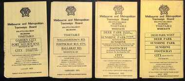
Ephemera - Timetable, Melbourne & Metropolitan Tramways Board (MMTB), Set of 14 MMTB Bus timetables, Jul. 1969
All July 1969 - no route numbers shown. .1 - Box Hill - Heidelberg - Templestowe .2 - East Kew - Box Hill - Doncaster .3 - Deer Park - Sunshine Park - Sunshine - Footscray - City .4 - Fishermen's Bend - City .5 - Williamstown Rd - Footscray Railway Stn - Ballarat Rd .6 - Garden City - City .7 - La Trobe University - Northland - West Heidelberg - City .8 - Box Hill - North Blackburn .9 - Bulleen - North Kew - City .10 - Clifton Hill - Elsternwick .11 - Box Hill - East Doncaster - Mitcham - Ringwood .12 - Deer Park - Sunshine Park - Sunshine - Footscray - City - Saturdays and Sundays - printed on pink paper. 13 - Warrandyte - Donvale Post Office - City 14 - Warrandyte - Park Orchards, Ringwood.Yields information about MMTB Bus services July 1969Set of 14 MMTB Bus timetables, folded sheets, providing timetables for specific routes, day of week giving information on tram times at specific time points, route map, sections and fares and organisation address - 616 Little Collins St. Melbourne.trams, tramways, timetables, tickets, bus services, fares, mmtb -
 Melbourne Tram Museum
Ephemera - Timetables - MMTB Buses - set of 13, Melbourne & Metropolitan Tramways Board (MMTB), 1971 to 1973
Timetables - provide information on ticketing, fares, timing points, with a description of the route and a map. Not all services had been allocated a route number at the time. 1 - Garden City - Port Melbourne - City - routes 201, 202 - August 1972 2 - Williamstown Road - Footscray - Ballarat Rd - Route 223, Feb. 1972 3 - Deer Park, Sunshine Park, Sunshine, Footscray - City - routes 217, 219, 220, 229, 231 and 218 - Feb. 1972 4 - Deer Park West, Sunshine Park, Sunshine, Footscray - City - July 1973 5 - Fishermen's Bend - City - routes 233, 235 and 237 - March 1972 6 - Clifton Hill - Esternwick - Point Ormond - routes 246, 247 and 248 - August 1972 7 - Latrobe Uni - Northland - West Heidelberg - City - routes 256, 251, 253, 254, 252 and 255 August 1972 8 - East Kew, Box Hill, Doncaster, Shoppingtown - routes 284, 285 and 270 - July 1972 9 - Box Hill, Mitcham, East Doncaster, Ringwood - routes 287, 286, 288, 282, 283, and 272 - July 1972 10 - Box Hill - North Blackburn, route 290, printed on white paper - Sep. 1971 11 - Box Hill - Doncaster, Shoppingtown, Heidelberg, Templestowe, Serpells Rd and Lower Templestowe - routes 293, 296, 297, 271 - July 1972 12 Deer Park, Sunshine Park, Sunshine, Footscray - City - routes 217, 219, 220, 229, 231 and 218 - Saturdays and Sundays, printed on green paper - Feb. 1972 13 - Fishermans Bend - City - routes 233, 235 and 237 - June 1973 Yields information about MMTB Bus services during the 1970s. Set of twelve MMTB Bus timetables - multifolded printed on yellow paper, unless noted otherwise. timetable, mmtb, buses, port melbourne, garden city, williamstown rd, footscray, ballarat rd, sunshine, deer park, fisherman's bend, clifton hill, esternwick, point ormond, la trobe university, northland, west heidelberg, east kew, box hill, doncaster, shoppingtown, mitcham, ringwood, blackburn, templestowe, lower templestowe, fishermans bend -
 Melbourne Tram Museum
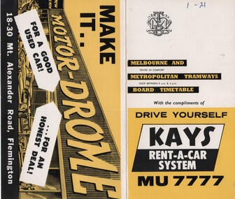
Ephemera - Timetable/s, Melbourne & Metropolitan Tramways Board (MMTB), "MMTB Timetables set of 39", 1960
Set of 39 MMTB Tram timetables, 2 fold sheets, , providing timetables for specific routes, route numbers, day of week giving information on tram times at departure time points, sections and fares, where applicable all night bus services. All signed by B. H. Misson, Traffic Manager. All sponsored by Kays Rent a Car and Motor Drome, 18-30 Mount Alexander Road, Flemington. The only one missing is Point Ormond. Not dated, based on fares - 1960 and possibly after Point Ormond had closed. .1 - Route 1, 21 - East Coburg - City .2 - Route 4, 4A, 4B - Carnegie - City .3 - Route 4D, 14 - East Malvern - City .4 - Route 5, 5A - Malvern Burke Road - City .5 - Route 6, 6A, 6B - Glen Iris - City .6 - Route 7, 7A, 7B, 7D - Camberwell - City .7 - Route 8, 8A - Toorak - City .8 - Route 9, 9A - Northcote via St Georges Road - City .9 - Route 9, 9B, 10, 12 - Sth Melbourne Beach, St Kilda Beach - City .10 - Route 10,11 - West Preston - City .11 - Route 15, 16 - St Kilda Beach - City .12 - Route 15, 22 - Moreland - City .13 - Route 18, 19, 20 - North Coburg - City .14 - Route 27, 28 - Hawthorn - Spencer St .15 - Route 42, 44, 45 - Mont Albert - City .16 - Route 48, 40, 41 - North Balwyn - Spencer St .17 - Route 49 - Essendon (Matthews Ave) - City .18 - Route 50, 54, 57, 58, 60 - West Maribyrnong - City .19 - Route 55, 56 - West Coburg - City .20 - Route 59 - Essendon Aerodrome - City .21 - Route 61, 62, 64, 65 - East Brighton - City .22 - Route 69 - Kew Cotham Road - St Kilda Beach .23 - Route 70, 71, 76 - Wattle Park - City .24 - Route 74, 75, 76 - Burwood - City .25 - Route 77, 80 - Prahran - City .26 - Route 78, 79 - North Richmond - Prahran .27 - Route 82 - Moonee Ponds - Footscray .28 - Williamstown Road - Footscray - Tram and bus .29 - Ballarat Road - Footscray - Tram and bus .30 - Russell St - - Footscray - Tram and bus .31 - East Brunswick - City .32 - Domain Road - City .33 - West Heidelberg - City .34 - Sunshine - City via Ballarat and Footscray Roads .35 - Sunshine - City via South and Dynon Roads .36 - Sunshine Park - City .37 - Garden City - City (Victoria St) .38 - Queens Bridge - Fisherman's Bend via Ingles St .39 - Queens Bridge - Fisherman's Bend via Lorimer St and Princes Bridge - Fisherman's Bend via Williamstown Rd.All have the route number in ink on the front cover - see image 5691i.jpg for standard cover.trams, tramways, mmtb, timetables, melbourne, fares, route 1, route 22, route 4, route 4a, route 4b, route 4d, route 14, route 5, route 5a, route 6, route 6a, route 6b, route 7, route 7a, route 7b, route 7d, route 8, route 8a, route 9, route 9a, route 9b, route 10, route 11, route 12, route 15, route 16, route 22, route 18, route 19, route 20, route 27, route 28, route 42, route 45, route 44, route 48, route 40, route 41, route 49, route 50, route 54, route 57, route 58, route 60, route 52, route 56, route 59, route 61, route 62, route 64, route 65, route 69, route 70, route 71, route 76, route 74, route 75, route 76, route 77, route 80, route 78, route 79, route 82, williamstown rd, ballarat rd, russell st, route 96, domain rd, west heidelberg, sunshine, garden city, queens bridge, fishermen's bend -
 Federation University Historical Collection
Map, Ballaarat Gold Field, 1861, 21/10/1861
A party of surveyors camped by Yuille's Swamp (later Lake Wendouree) and surveyed the countryside for a map to be produced by the Geological Survey of Victoria. In November 2004 the Central Highlands Regional Library presented a special edition of 200 copies of the 1861 map reproduced from a copy in their collection. Original geological map of Ballarat showing property, waterways, mines, churches, schools, water races, and garden reserves. It was compiled and drawn from the surveys of Mining Surveyors Davidson, Fitzpatrick and Cowan.Compiled & Drawn from the Survey of Mining Surveyors Davidson, Fitzpatrick and Cowan & the Plans in the Surveyor General's Office by J. Brahe, 21st October 1861. R. Brough Smyth, Secretary for Mines. The Honourable J.B. Humffray, M.L.A. Commr of Mines.ballarat, map, davidson, robert brough-smyth, fitzpatrick, cowan, yuille's swamp, public garden reserve, manure depot, black hill, ballarat east, old post office hill, pennyweight hill, claytons hill, golden point, mining, railway, cricket ground, swamp creek, cemetery, sludge reserve, bakery hill, gaelic church, juvenile reformatory, orphanage, specimen hill, eureka lead, cattle yard hill, dalton's flat, chinese village, poverty hill, railway reserve, little bendigo diggings, pound reserve, allied armies, flour mill, agricultural reserve, marsh, survey reserve, survey corps, white flat, yarrowee, yarrowee creek, brache, j. brache, survey, ballaarat gold field 1861 -
 Ballarat Heritage Services
Magazine - digital copy, Ballarat East high School Magazine 1959, 1959
Ballarat East High School was established in the early 1950s. This is one of the earliest magazines produced. School History: In February, 1955, Ballarat East High School opened in Hopetoun Street, in the vacated weatherboard buildings of the Girls’ Secondary School. In 1956, however, the School moved to its present site in Fussell Street, but because of the lack of space, Woodwork and Cookery classes were still held at Hopetoun Street. Since then there has been steady progress. The original building was extended, more classrooms and a library being built. A Domestic Science block was completed in 1957. Later, as mentioned elsewhere, sheltersheds, basketball courts, a bidycle shed and a canteen were provided for the pupils from funds raised by the Parents’ Association. Where there were previously bare areas of clayey soil we now have asphalt paths and neat gardens. Shrubs were planted, and seats, painted in the School colours, were places around the asphalted areas. (Page 5, 1959 BEHS School Magazine) 3 pdf files holding multiple pages of 1959 School Magazinebehs, ballarat east high school, ballarat east, magazine, 1959