Showing 605 items
matching central park
-
 Lakes Entrance Historical Society
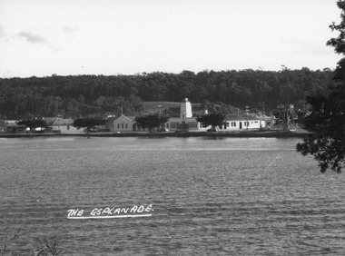
Photograph, 1950c
Black and white photograph of the Esplanade, showing Cunninghame Arm in foreground, forrested slope of Kalimna escarpment in background, Central Hotel with tower positioned on corner of the Esplanade and Mechanics Street. Cars of the era parked in front of hotel. Lakes Entrance Victoriahotels, township, waterfront -
 Ringwood and District Historical Society
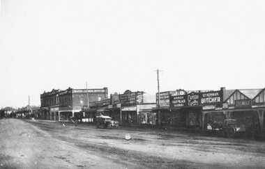
Photograph, Maroondah Highway Central, Ringwood. Shops in Maroondah Hwy, 1923
Black and white photograph (2 copies) Typed below photograph: "Maroondah Highway Ringwood 1923. Shops in foreground later to become Safeway and Eastland car park." -
 Ringwood and District Historical Society
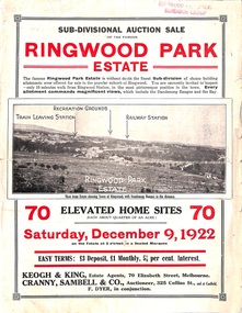
Flyer, Sub-divisional auction sale advertisement - Ringwood Park Estate, Ringwood, Vic. - 1922
Folded double-sided page with black and white photographs of local views with black and red print advertising auction sale on Saturday 9th December, 1922, - 70 residential home sites, including terms of sale, locality map, and description of local facilities and services. Subdivision includes Wonga Road (later Loughnan Road), William Street, Andrew Street, and Harrison Street. Vendors Solicitors - Rigby & Fielding, 60 Market Street, Melbourne. Estate Agents - Keogh & King, 70 Elizabeth Street, Melbourne, Telephone 6938. Auctioneer - Cranny, Sambell & Co., 325 Collins Street, Melbourne, Telephone Central 5067 and 5077. -
 Stawell Historical Society Inc
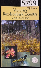
Book, Malcolm & Jane Caulder, Victoria’s Box Iron Bark Country - A Field Guide, 2002
This is the definitive guide to the Box-Ironbark forests of Central and North-East Victoria First published in 1994 as The Forgotten Forests. By the Victorian National Parks Association Ltd.Cardboard cover with yellow band at top containing Title in green print, below which are 3 colour photographs one showing bushland, one showing closeup of a flower, the other showing a bird. Logo for the Victorian National ParksVictoria's Box-Ironbark Country. A Field Guide Autographed by Ian McCann (Photographer)stawell -
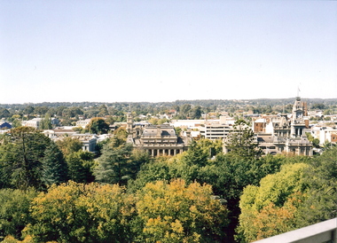 Bendigo Historical Society Inc.
Photograph - LANDSCAPE VIEW OF BENDIGO, c2001
Color photograph. View of Bendigo looking South East from the look out tower in Rosalind Park. Former Bendigo Post Office on the right side, Courthouse in centre, Town Hall far side of Courthouse and the Shamrock Hotel on far side of Post Office. Physical description: Unmounted photo. Inscriptions/Markings: Bendigo from look out tower, Rosalind Park, April 2001.Willa, Wendybendigo, bendigo streetscape, bendigo central, post office, court house, bendigo town hall, shamrock -
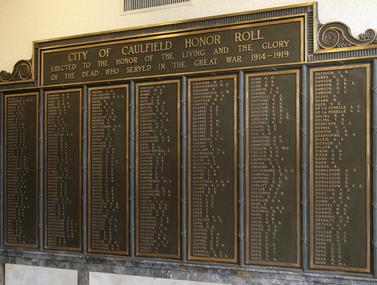 Glen Eira City Council History and Heritage Collection
Monument - Honour Roll, City of Caulfield Great War Honor Roll, 1930-31
Caulfield Town Hall was built in 1891. By the 1920's the population of the area had grown rapidly and the building was no longer fit for purpose. A major redevelopment was undertaken in 1930-31, including the building of the large portico entrance and entrance hall. This roll of honour was installed around the inside walls of the entrance hall. Labour on the rebuilding project was largely undertaken by unemployed workers, one of the key ways that Council supported the community during the depression. This roll of honour has considerable local significance to the community of Glen Eira across all of the significance criteria. Alongside the war memorial in Caulfield Park and Caulfield's avenue of honour this roll is a central site of memorial for the residents of the municipality who served in the First World War. It contains the names of all Caulfield residents, including nurses, and makes no distinction between those who returned and those who were killed, making it a rare example amongst Victoria's memorial rolls. The extensive list of names makes it a valuable research tool, and its capacity to interpret municipal, social and military history makes it one of Glen Eira's most significant sites. Large, rectangular, bronze panels displaying polished bronze relief letters alphabetically detailing names of living and deceased citizens who served in the First World War. The panels have been mounted on stone walls with a marble appearance. There are 31 panels - vertically arranged in groups of 9, 1, 2, 2, 4, 3, 2, 3, 2 (clockwise direction) on the walls of the portico entrance foyer, Glen Eira Road entrance to Glen Eira Town Hall. Each panel has 50 names, for a total of 1,550 names. City of Caulfield Honor Roll / Erected to the honor of the living and the glory / of the dead who served in the Great War 1914-1919 (See attached file for list of names)honour roll, caulfield, glen eira, great war, world war one, ww1, wwi, 1914, 1919, monument, memorial -
 Bendigo Historical Society Inc.
Document - Hustlers, Sheepshead and Deborah lines of reef
Albert Richardson was a mining historian who wrote widely on the mines of the Bendigo Goldfield. The park opposite the Goldmines Hotel in Marong Road, is named in his honour. Five page document, hand written by Albert Richardson on lined foolscap and edited with cross-outs and insertions, . The mines along the Hustlers line of reef and the Sheepshead line of reef are described. Mines listed on Hustlers line of reef: Fortuna Hustlers (1888 - 1913), shaft 2,240 feet at rear of Buckell and Jeffrey's offices; Royal Hustlers Reserve No. 2 - two shafts 'City" 860 feet, now covered by R.S.L. building Pall Mall, steel poppet legs 60 ft high and 'Park Shaft" at rear of Camp Hill School, 1,775 feet, steel poppet legs 60 feet high; Hustlers Hill Group first worked by Jonathan Harris in 1853 and bounded by Valentine, Anderson and Ironbark Creek to the north and Milroy Street to the east, one of first areas worked for quartz reefing. It with Garden Gully line west and Victoria Hill Ironbark, formed by far the richest cross section of the Bendigo Goldfield. Great Extended Hustlers (1865-1921) close to intersection of Anderson Street and Hustlers Road, mullock heap against road and shored up around shaft, steel poppet legs now at Wattle Gully mine, Chewton, large winding machine, air compressor south of shaft and 36 head crushing battery. Hustlers Reef (Old Hustlers) and Hustlers Reef No. 1, two shafts, main 2,210 feet, about 220 yards east of Moran Street and against Fenton Street. , No. 1 shaft 1,140 feet and about 155 yards east of Moran Street. Lansell's Comet, Lightining Hill line, 2.100 feet, on Comet Hill approx 70 yards west of Holmes Road, near Comet Creek, steel poppet legs. United Hustlers and Redan (1876-1918), main Redan, 1,830 feet about 155 yards west of Sandhurst Roead, in line with Comet Hill State School, this hill known as Redan Hill. North, or New Hustlers, once known as Agnew Hustlers, wooden poppet legs, south side, Kneebone Street, Eaglehawk. Derby line, Johnson's No. 3, South Johnson's (east shaft of Collman and Tacchi) 439 feet on west wide of Woods Street, south of Wetherall Street. Paddy's Gully Line, south to north, some shafts - Lansell's 'Sandhurst" ('Needle") Eaglehawk Road shaft 2,425 feet, about 50 yards east of Needle Loops, a brick square sided chimney with Cleopatra Needle top. British American, 789 feet, just south of Holdsworth Road. Collman and Tacchi, main shaft 2,588 feet, 60 yards west of Eaglehawk Road, California Gully. Deborah Line of Reef, The Deborah (1932-1954) shaft 2.017 feet, west of Adams Road and south of Abel Street, Quarry Hill. North Deborah (1937 - 1954) shaft 1,151 feet, Breen Street, Quarry Hill, steel poppet legs. Central Deborah (1939-1954) shaft 1,347 feet Sheepshead line of reef, Lansell's South Red, White and Blue, shaft 2,124 feet, north east of Bellevue Road and 220 yards east of Adams Road. The New Red, White and Blue Consolidated (Big Blue) main shaft 2,416 feet. Lansell's Bendigo Battery 105 head, north of 'Big Blue" on his freehold lease, commenced crushing on 24th February 1895. After closing was erected as the Showground's Industrial Hall, July 1926. North Red, White and Blue, burnt down February 1926, new company 1934, closed 1938. Document is part of the Albert Richardson Collection of Bendigo mining history. bendigo, gold mining, deborah line of reef, sheepshead line of reef, hustlers line of reef, royal hustlers reserve mine, hustlers hill group of mines, great extended hustlers, hustlers reef no. 1, lightning hill line, old comet, collman and tacchi, lansell's comet, north deborah, central deborah, dhrrpdhrsf linr og trrg, new red, white and blue consolidated mine, big blue, lansell's bendigo battery, north red, white and blue mine, albert richardson collection -
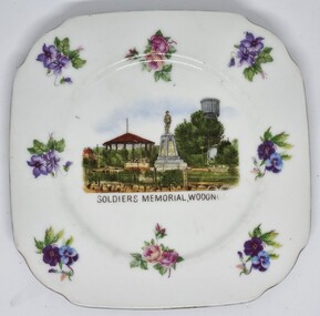 Wodonga & District Historical Society Inc
Souvenir - China Souvenir Plate Soldiers' Memorial. Wodonga, Victoria China, c1924 - 1939
This item is from a collection donated by descendants of John Francis Turner of Wodonga. A wide range of small china pieces carrying scenic views of holiday destinations or key locations were a popular kind of souvenir during much of the 20th century. Several different items have been produced to commemorate Wodonga and its landmarks over time. These items document key changes in Wodonga and its heritage. This plate depicts three key landmarks in Wodonga. THE SOLDIERS' MEMORIAL in Wodonga was unveiled on Tuesday 18th November 1924. It was designed by Messrs. Hosken & Co., of Hawthorn, Victoria. The monument is all of Australian workmanship. The pedestal is made of Harcourt granite, 9ft x 9ft at the base, and rising in seven courses to a height of 10ft 2in. The emblems (rising sun and wreath) are of bronze, and the lettering of the inscription and names of fallen soldiers are in raised lead letters. Originally the Memorial was completed with a full life size, 6ft in height, sculpture of an Australian soldier in Sicilian marble. The memorial bore the inscriptions: ERECTED BY THE RESIDENTS OF WODONGA AND DISTRICT IN MEMORY of the Men of this Town and District who fell in the Great War, 1914-1919, Also in grateful recognition of the men who served and returned. “Lest We Forget.” In 1982, due to frequent vandalism and high cost of materials to repair, the soldier statue was removed and later installed at the RSL Rooms. THE WATER TOWER is a major landmark of High Street, Wodonga. It began operation from January 1924 until it ceased operation in 1959. It stood unused for a decade until the lower section was modified and put to use as “ The Tower’s Cobbler’s Inn” in 1962. In 1972 Wodonga City Council proposed to demolish the Tower. Their suggestion received an unfavorable response from the city’s citizens, so the Tower still stands today. THE BAND ROTUNDA was officially opened on Sunday 5th September 1920 at the naming of the triangular reserve at the corner of High and Hovell Streets as Woodland Grove. The Wodonga Band gave a public performance on this occasion. The tri-coloured ribbon, which stretched across the entrance to the Rotunda was cut by Mrs R.H Murphy, daughter of Mr. John Woodland, secretary of the Wodonga Shire Council for 35 years, after whom the area was named. The rotunda has since been moved to Martin Park, Wodonga.This item comes from a collection used by a prominent citizen of Wodonga. It is also an excellent example of souvenir items created featuring landmarks to represent the city of Wodonga.A china plate depicting the Soldiers' Memorial Wodonga. The central coloured image is surrounded by a 8 representations of a variety of flowers and a silver edge trim. The makers mark underneath the dish was used between 1918 - 1939 so assists in establishing provenance of the irem.Beneath image: "SOLDIERS' MEMORIAL WODONGA On back of dish, Beneath a crown " VICTORIA CHINA CZECHOSLAVAKIA"victoria china, souvenir wodonga, wodonga soldiers memorial, woodland grove wodonga -
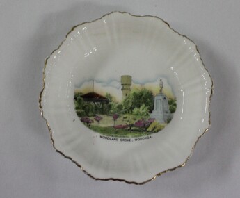 Wodonga & District Historical Society Inc
Memorabilia - China Souvenir Bowl Woodland Grove Wodonga, c. 1920 - 1940
A wide range of small china pieces carrying scenic views of holiday destinations or key locations were a popular kind of souvenir during much of the 20th century. Several different items have been produced to commemorate Wodonga and its landmarks over time. These items document key changes in Wodonga and its heritage. This plate depicts three key landmarks in Wodonga. THE SOLDIERS' MEMORIAL in Wodonga was unveiled on Tuesday 18th November 1924. It was designed by Messrs. Hosken & Co., of Hawthorn, Victoria. The monument is all of Australian workmanship. The pedestal is made of Harcourt granite, 9ft x 9ft at the base, and rising in seven courses to a height of 10ft 2in. The emblems (rising sun and wreath) are of bronze, and the lettering of the inscription and names of fallen soldiers are in raised lead letters. Originally the Memorial was completed with a full life size, 6ft in height, sculpture of an Australian soldier in Sicilian marble. The memorial bore the inscriptions: ERECTED BY THE RESIDENTS OF WODONGA AND DISTRICT IN MEMORY of the Men of this Town and District who fell in the Great War, 1914-1919, Also in grateful recognition of the men who served and returned. “Lest We Forget.” In 1982, due to frequent vandalism and high cost of materials to repair, the soldier statue was removed and later installed at the RSL Rooms. THE WATER TOWER is a major landmark of High Street, Wodonga. It began operation from 1924 until it ceased operation in 1959. It stood unused for a decade until the lower section was modified and put to use as “ The Tower’s Cobbler’s Inn” in 1962. In 1972 Wodonga City Council proposed to demolish the Tower. Their suggestion received an unfavorable response from the city’s citizens, so the Tower still stands today. THE BAND ROTUNDA was officially opened on Sunday 5th September 1920 at the naming of the triangular reserve at the corner of High and Hovell Streets as Woodland Grove. The Wodonga Band gave a public performance on this occasion. The tri-coloured ribbon, which stretched across the entrance to the Rotunda was cut by Mrs R.H Murphy, daughter of Mr. John Woodland, secretary of the Wodonga Shire Council for 35 years, after whom the area was named. The rotunda has since been moved to Martin Park, Wodonga. This item has local historic and social significance as it depicts which features of the city the community valued in the past. It has artistic significance as an example of the kinds of souvenirs used widely across Australia to represent communities and the landscape.A white glazed china souvenir bowl. Frilled edge. Includes a painted representation of Woodland Grove, Wodonga, VictoriaBeneath the painted central image "WOODLAND GROVE, WODONGAwodonga, souvenirs, woodland grove, ceramics -
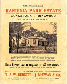 Ringwood and District Historical Society
Flyer, Land Sale Brochure, Kardinia Park Estate, North Ringwood, Vic. - circa 1948
Folded buff-coloured land sale advertisement for Kardinia Park Estate in Warranwood area of North Ringwood, including terms of sale, area map, layout plan of the estate, and summary of local facilities and services. Front page features photograph of a man and dog in front of a house captioned as Lot 1 on four acres shown on the estate layout as cnr of Brysons Road and Range View Parade (later Omeo Parade). Second page includes bushland swimming pool photograph and promotional information for prospective buyers.Subdivision includes Kardinia Crescent, Wonga Road, Brysons Road, Range View Parade (later Omeo Parade), Motor Coach Road (later Wonga Park Road, then Warranwood Road). (Agent/s) T.A.W. Burkitt, Main Street, Ringwood, Phone (9 to 6) Ringwood 242, Evenings, Ringwood 157, and J. McEwan & Co, 317 Collins Street, Melbourne, Phone 6750 Central. -
 The Beechworth Burke Museum
Photograph - Stereoscopic Photograph, c1900
The gardens of Ovens District Hospital were laid out and planted by R H Jenkyns in 1874. Over 200 species of trees and shrubs were planted, including several large Himalayan Cedars (Cedrus deodora), a Coast Redwood (Sequoia sempervirens), rare Scots Pine (Pinus sylvestris), Pencil Cedar (Juniperus virginiana), Bunya Bunya Pines (Araucaria bidwillii), a Purple-leaved Dutch Elm (Ulmus x hollandica 'Purpurascens'), American Ash (Fraxinus americana), Pinus radiata, and numerous Populus alba trees and suckers. The gardens were considered integral to the healing process, also including orchards and kitchen gardens. In the 1880s, tourists flocked to Beechworth as the area became recognised as a health resort and picturesque beauty spot. Although the hospital closed in 1940, and parts were subsequently demolished, the gardens remain and form part of the site's listing on the Victorian Heritage Register. This photograph is part of a collection of items held by the Burke Museum relating to Ovens District Hospital. At the time of being built, the Ovens District Hospital was the only hospital between Melbourne, Victoria, and Goulburn, New South Wales, treating patients from all of north-east Victoria, including Indigo Shire.Black and white stereoscopic photograph mounted on card.Reverse: 97-2292 / View up centre path of Hospital / A03177 / BMM3177 / Note: A03178 / View of the central path of the Ovens Hospital / (Church St) Beechworthovens hospital, hospital garden, gardens and parks, ovens district hospital -
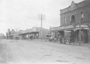 Ringwood and District Historical Society
Photograph, Maroondah Highway Central, Ringwood. Coffee Palace and shops along Main Street between Adelaide Street and Melbourne Street. c1920's
Black and white photographWritten on back of photograph: "Land values - Main Street, Ringwood - land worth £50 pounds a foot." Image is taken from a land sale brochure and shows cars and horse drawn vehicles parked in front of buildings. -
 Melbourne Tram Museum
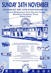
Poster, Public Transport Corporation (PTC), "Celebrate the 75th Anniversary of Central Melbourne's First electric trams - Hawthorn Tramways Trust - Wattle Park", Nov. 1991
Poster - A2 size, printed on gloss paper in blue ink, for the "Celebrate the 75th Anniversary of Central Melbourne's First electric trams - Hawthorn Tramways Trust - Wattle Park", Sunday 24/11/1991. Gives event details, cavalcade of trams, times. Has the various logos of councils who made up the trust on the bottom edge along with other supporting organisations. Has images of trams and tickets. Includes the event to hand over Wattle Park from Public Transport Corporation PTC to Melbourne Water. See Reg Item 5402 for a program of the events.trams, tramways, htt, wattle park, ptc, 75th anniversary, cavalcade -
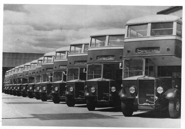 Melbourne Tram Museum
Photograph - Set of 2 Black & White Photograph/s, Public Transport Corporation (PTC), 1940
Set of two black and white prints of double deck buses: Photographs made from illustrations by the MMTB. .1 - M&MTB Leyland Titan TD5c line-up at the Central Bus Garage, North Fitzroy, 1940 - 13 buses - H55 .2 - Bus No. 244 photographed at a park - has MMTB name on the side - H52. All have PTC Copyright Stamp on rear. Two copies of each held.trams, tramways, buses, double deck buses, central bus garage, leyland, td5c class, bus 244, mmtb buses -
 Melbourne Tram Museum
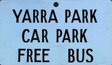
Sign, The Met, "Yarra Park Car Park Free Bus", c1980?
Sign - metal sheet black letters with a light blue background with the words "Yarra Park Car Park Free Bus" Has a hole centrally along the top edge. Donor advised used on buses that ran from the city to Yarra Park possibly during an event.trams, tramways, yarra park, buses, melbourne -
 Ringwood and District Historical Society
Photograph, Maroondah Highway Central, Ringwood. Car parking on Ringwood oval, c1960's
Black and white photographs (3 images)Photographs show vehicles parked on Ringwood oval and were used during litigation processes in the Supreme Court relating to the development of Eastland Shopping Centre. Stamped on back of photograph- "Edward G Adamson. A.R.P.S. No 3443 dated May 63. -
 Ringwood and District Historical Society
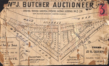
Poster - Land Sale, Wm J. Butcher, Auctioneer - Albert Park Estate, Ringwood - c.1890
Central section of land sale subdivision advertisement glued to heavy cardboard backing. Photocopied SLV image of original advertisement shows map of 117 allotments for sale in Main Lilydale Road (later Old Lilydale Road), Wandin Road (later Mount Dandenong Road), Joseph Street, Dynes Street, Albert Street (later Wyrunga Street) and Government Road (later Carcoola Road), Ringwood East.Solicitors - Jenningw & Wright, Queen Street. Surveyors - J.&H. Tarrant, Elizabeth Street. Terms £2 10s cash deposit, balance three years at six per cent. -
 Bendigo Historical Society Inc.
Photograph - LA TROBE UNIVERSITY BENDIGO COLLECTION: CAMP HILL STATE SCHOOL
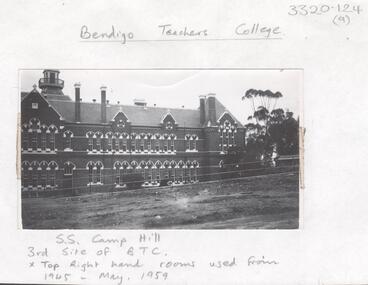
(a) A black and white photograph of Camp Hill State School the third site of Bendigo Teachers' College. The top right hand rooms were used from 1945 to house the college until May, 1959. (b) A Bendigo 'Advertiser' photo of the Central State School situated in Rosalind Park, Bendigo. See 3320.100bendigo, education, camp hill state school, la trobe university bendigo collection, collection, bendigo, education, tertiary education, teacher training, photo, photos, photograph, photographs, photography, state school, primary school, bendigo teachers' college, central state school, camp hill state school, rosalind park, ms. j.c. burnett, mr. geoff pryor, newspaper, advertiser, place, building -
 Bendigo Military Museum
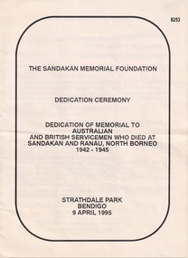
Pamphlet - SANDAKAN MEMORIAL 1995, C. 1995
This service was to dedicate a Memorial to Australian & British Servicemen who died at Sandakan and Ranau, North Borneo 1942 - 1945. It was unveiled at Strathdale Park Bendigo on 9.4.1995. The Official Party were; Mr Peter Ross Edwards AM, Chief Commissioner The City of Greater Bendigo, Mr J.S. Millner AM, Chairman The Sandakan Memorial Foundation. The Requiem was read by Father John Brendan Rogers OFM. Unveiling the Memorial by, Mr Peter Ross Edwards AM. Dedication of the Memorial by; Father John Brendan Rogers OFM, Chaplain 8th Division Sandakan and Kuching, Chaplain Gary Kenney, Australian Army. Laying of the wreaths, Wreath Marshalls supplied by Bendigo RSL Sub Branch, Australian Army Band Melbourne. The ODE was read by; President Bendigo RSL Mr Cliff Clohesy. The Catalflaque Party was supplied by; Army School of Survey Regiment Bendigo.Pamphlet off white colour, A4 folded making 8 pages total, all print in black, one staple central holding together.On the front, "The Sandakan Memorial Foundation, Strathdale Park Bendigo 9 April 1995"brsl, smirsl, sandakan, strathdale -
 Bendigo Historical Society Inc.
Document - VICTORIA HILL - THE BENDIGO DIGGINGS, PRELIMINARY DRAFT FOR BROCHURE
BHS CollectionNine typed pages of notes on a preliminary draft for a brochure on the Bendigo Diggings. First part is the objective which is to preserve the mining history and to have exhibits in the places they were used, e.g. quartz mining machinery exhibited in a quartz mining area, not on an alluvial field. Part B is historical notes on the area. Part C is the Site - Victoria Hill area. Part D is Stage One which consists of carpark area, technological museum, restaurant, mineral haulage line, picnic ground, earthworks and planting over the area. Part E is Stage Two which will consist of the open-air exhibits, in the area surrounded by the mineral haulage line, and the Central Nell Gwynne mine on the west side of the site. Part F is Stage Three which will consist of the winery, the steam tram track, the lake, the wildlife sanctuary and various buildings associated with gold mining. Part G is Costing with the prices to be filled in. Parts H and I are the Appeal and the Committee. Details to be filled in. Notes prepared by Albert Richardson.mining, marketing, victoria hill, victoria hill, the bendigo diggings - preliminary draft for brochure, aust national travel association, tullamarine jetport, emu bottom homestead, kyneton historical museum, chinese joss house, eaglehawk museum, whipstick scrub, cairn curran reservoir, castelmaine historical museum and market hall, national trust, ballarat hiatorical park, echuca's hopwood gardens, swan hill folk museum, gibson's mount alexander no 2 squatting run, captain brown, chief commissioner wright, hustler's reef, thomas hustler, mining board, drainage of reefs act 1862, first world war, bendigo amalgamated goldfields, second world war, sandhurst, w c vahland, battery trams, horse trams, steam trams, electric trams, central nell gwynne mine, theodore ballerstadt, george lansell, new chum hill, ballerstadt's open cut, 180 mine, new chum syncline battery, william rae, victoria quartz, wittscheibe's 'jeweller's shop', luffsman and sterry, gold mines hotel, adventure, bendigo and district tourist association, bendigo city council, bendigo branch of the royal historical society of victoria, professor brian lewis, school of architecture and building at the university of melbourne, taylor horsfield, lord robert cecil, south australian gold commissioner -
 Bacchus Marsh & District Historical Society
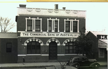
Photograph, Commercial Bank of Australia Main Street Bacchus Marsh
The Commercial Bank of Australia building was constructed by J. F. Taylor in 1907 and shortly after commenced operations as a bank. The building was in use as a CBA bank until 1976 when it was demolished and a new building erected. The CBA continued its operations at this location; subsequently, various banks, such as the Bank of Melbourne and Westpac operated there. Part of the new building is now in use as a newsagency. The original architectural plans for this building designed by Walter Butler are held by the State Library of Victoria and can be viewed online through the Library's website: Citation: Butler, W. R., & Taylor, J. F. (1906). Design for banking premises at Bacchus Marsh for the Commercial Bank of Australia Ltd. URL: http://handle.slv.vic.gov.au/10381/473561 Black and white photographic print. Photograph of the Commercial Bank 138 Main Street Bacchus Marsh. On the left is a smaller brick building adjoining the bank. On the right there is a partial shot of a shop called The House of Hodgson. The bank building itself is shown as a substantial two-story brick building, the top storey appearing to be a dwelling with three ornamented windows furnished with curtains and blinds. The storeys are divided by a white panel bearing the words "The Commercial Bank of Australia Ltd". The lower storey has a central entrance with a panelled door. The door is flanked by two windows with reinforced lattices. The windows and door are surmounted by decorative arches reminiscent of Spanish Moorish architecture. A car (possibly a 1937 Dodge) is parked on the street. A lone girl stands on the footpath waving at the photographer.On the back: In pencil: 1937 Dodge?shops bacchus marsh vic., main street bacchus marsh vic., banks bacchus marsh vic., commercial bank of australia bacchus marsh -
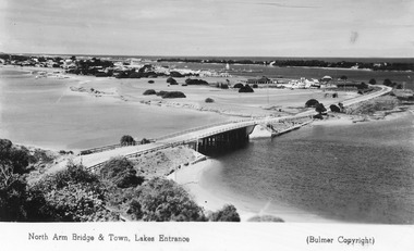 Lakes Entrance Historical Society
Postcard - Lakes Entrance from Jemmys Point, Bulmer H D, 1950c
Township of Lakes Entrance from Jemmys PointColour tinted postcard of township showing bridge across North Arm; town buildings including Club Hotel, Methodist Church, Maranui Guest House; tower of Central Hotel; jetties in Cunninghame Arm, and sand dunes. Caravan parked beside concrete brick constructed toilet block opposite road to Bullock Island. Footbridge across Cunninghame Arm in distance, also lookout tower on Esplanade, and Life Saving tower over hummocks. Lakes Entrance VictoriaNorth Arm Bridge and Town, Lakes Entrancetownship, jetties, guesthouses, islands, hotels -
 Bendigo Historical Society Inc.
Document - LONG GULLY HISTORY GROUP COLLECTION: HISTORICAL GUIDE TO BENDIGO
Brochure with an invitation to visit Historical and Mining Museum in Mechanic's Institute, Eaglehawk. Drawing of poppet legs on the front with The Royal Historical Society of Victoria Bendigo Branch. Historical Guide to Bendigo including Self Tours of Bendigo's Famous Goldfields. Forward by John Hattam. Contributors are: H Biggs, Miss L J Parry, A Richardson, L C Bennetts and Edith Checcucci. Credits - The Bendigo Advertiser, Cambridge Press, Mines Department (Bendigo) and J R W Purves. Items include Bendigo Tramways Compiled by H Biggs, Early Bendigo Hotels Compiled by L C Bennetts, Eaglehawk Compiled by H Biggs, Noted Events Compiled by June Parry, The Bendigo Post Office Compiled by LC Bennetts, The Bendigo Goldfield. Introduction to Field and Guide to Some Famous Mines Compiled by A Richardson. Photos include: Pall Mall Bendigo, Ravenswood Homestead, An Early Battery at Kangaroo Flat, Historic High Street Golden Square, The Lonely Grave, Battery Tram c1888, Steam Tram c1892, Electric Tram c1903, The New Chum Railway Golden Square, United Hustlers and Redan Mine Sandhurst Road, Central Deborah Violet Street, Deborah Mine Quarry Hill, Deborah Mine 1000 ft level, First Motion Winding Engine at Central Deborah, Victoria Hill Area, and Looking south from New Chum Hill in 1890's. Also 11010.254, 255, 268, 288a, 288b, and 289.bendigo, history, long gully history group, the long gully history group - historical guide to bendigo, the royal historical society of victoria bendigo branch, historical and mining museum, mechanic's institute eaglehawk, librarian mechanic's institute, miss j parry, john hattam, h biggs, a richardson, l c bennetts, edith checcucci, bendigo advertiser, cambridge press, mines department (bendigo), j r w purves, mr a o'keefe, shire of marong, the sandhurst and eaglehawk tramway company, mr j taylor, mr j hanson, the bendigo tramway company, electric supply company, coliban water suply, juvenile industrial exhibition, geo lansell, cr a harkness, salvation army, vine and fruitgrowers association, decentralisation league, constable thomas ryan, miners association, art gallery, post office, miss broadfoot, bendigo hospital, opera company, bendigo development league, victorian women's franchise league, ana hall, the bendigonian, law courts, temperance hall, trades hall (old wardens court), roman catholic cathedral, shamrock hotel, bendigo philosophical society, old bendigonian society, bendigo fire brigade, bendigo volunteers to south african war, hawkins, porcupine inn, criterion hotel, royal hotel, bendigo hotel, black swan hotel, gillies bakery, hibernian hotel, sandhurst hotel, freemasons hotel, courthouse hotel, shamrock hotel, governor hotham, heffernan & crowley, new chum railway, victoria quartz, shenandoah, shamrock mine, hercules no 1 (originally pearl east), hercules new chum (late pearl), carlisle mine, mr arblaster, meurer, sandhurst bee, benevolent asylum, bendigo gas company, a lloyd, coliban water supply scheme, cr w v simons, eaglehawk council, j mouat, sir henry barkly, agricultural and horticultural exhibition, sandhurst and eaglehawk boroughs, cr john mcintyre, latham and watson's mine, galatea (model ship), st paul's church of england, rev g p despard, fine arts exhibition and exposition, bendigo rifle association, strathfieldsaye shire hall, corporate high school, bendigonian society, richard andrews, easter fair, g aspinall, j burnsides, sir h manners sutton, beehive stores, mining exchanges, bendigo water works, city family hotel, bendigo united friendly society medical institute and dispensary, benevolent asylum, jewish synagogue, masonic hall, school of mines, mr j h abbott, australian natives association, royal princess theatre, albion hall, central state school, high school, gravel hill state school, electricity commission, james mouat, warring natives, the rocks, joseph crook, gold discovery, marong district roads board, camp hotel, mr charles sherratt, city of bendigo, mt alexander north run, grice and heape, ravenswood, gibson and fenton, mrs john kennedy, mrs patrick farrel, mr j a paton, mr lachlan mclachlan, theatre royal, sir charles and lady hotham, harney's bridge, e j ennor, sandhurst fire brigade, the health of towns act, mr townsend, cornish & co, bendigo pottery, bendigo agricultural society, pike or pyke, baby health centre, sandhurst post office, government survey office, sandhurst trustees company, mr h b briston, savings bank, telegraph office, sir henry brougham lock, hon sir john nimmo, sandhurst public offices, the new prince of wales mine, new prince of wales no 2, the whip and jersey, lansell's big 180, new chum and victoria mine and battery, new chum railway, koch's pioneer, south new moon, catherine reef united, new moon, virginia mine, south belle vue, new chum railway, central nell gwynne, north nell gwynne, ironbark mine, new chum syncline, hercules, herculesl energetic, roberts & sons, harkness & co, horwoods, great southern, ulster, carlisle, cornish, new st mungo, duchess tribute, south devonshire, hopewell mine, saxby mine, mcnair & co, mr king, bourke and wills, sandhurst hotel, the dascombe nugget, victoria nugget, r r haverfield, ballerstedt, rae, wittscheibe, lazarus, cave and amos, bendigo amalgamated goldfields, bendigo mines limited, the deborah, north deborah, central deborah, the new red white and blue consolidated (big blue), union, lansell's new red white and blue 9later no 3 shaft), h harkness & co, thompson & co, central deborah, lansell's bendigo battery, north red white and blue, central red white and blue, roberts and sons, little 180 (originally lansell's 180 no 2 shaft), john brown knitwear factory, south ironbark originally victoria consols east shaft, ironbark (originally ironbark east shaft), manchester arms hotel, wattle gully mine chewton, hercules, old wheal-owl, central nell gwynne, gold mines hotel, bendigo city council, jack barker, the new chum syncline, the courier of the mines, telegraph office, bendigo cemetery, white hills cemetery, eaglehawk cemetery, kangaroo flat cemetery, new moon, suffolk united, north new moon, fortuna hustlers, buckell & jeffrey's, royal hustlers reserve no 2 (city and park shafts), jonathan harris, latham and watson, great hustlers, great extended hustlers, j hustler, latham, watson, tribute or pups shaft, bendigo's worst mining disaster, hustlers reef (old hustlers), hustlers reef no 1, lansell's comet, the old comet (cooper's claim), united hustlers and redan, comet hill state school, k k shaft, north or new hustlers (agnew hustler), johnson's no 3, south johnson's, lansell's sandhurst needle, cleopatra needle top, british american, collman and tacchi, south virginia, saddle reefs and spurs, pall mall bendigo, ravenswood homestead, an early battery at kangaroo flat, historic high street golden square, the lonely grave, battery tram c1888, steam tram c1892, electric tram c1903, teh new chum railway golden square, united hustlers and redan mine sandhurst road, central deborah violet street, deborah mine quarry hill, deborah mine 1000 ft level, first motion winding engine at central deborah, victoria hill area, looking south from new chum hill in 1890's -
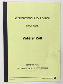 Warrnambool and District Historical Society Inc.
Booklet, Warrnambool City Council voters roll 2001, 2002
This is a booklet giving the names and addresses of voters for the local Council in Levy’s Ward in the City of Warrnambool in 2002. At that time the Warrnambool City Council was divided into seven Wards with one Councillor representing each Ward. The seven Wards at that time were Levy’s, Botanic, Cassady, Pertobe, Proudfoot, Sherwood, and Wollaston. In 2004 the Wards were abolished and seven Councillors then represented the whole City of Warrnambool. In October 2024, the Warrnambool municipality covered 120sqkms and returned to a seven ward council. In 2024, the wards were Botanic, Central, Hopkins River, Pertobe, Platypus Park, Russells Creek and Wollaston. In 2002 Glenys Phillpot was the Councillor representing Levy’s Ward. This booklet is of interest as it contains the names and addresses of those enrolled in Levy’s Ward in Warrnambool in 2002. It will be a useful booklet for researchers. This is a booklet of 22 pages containing the names and addresses of voters in the Levy’s Ward of Warrnambool in 2002. The cover is yellow and the booklet is bound with black taping. The printed list of names is in black type. Front Cover: ‘Warrnambool City Council’ ‘Levy’s Ward’ ‘Voters’ Roll’ ‘Certified Roll Entitlement Date: 17 December 2001.’ ‘February 2002 Victorian Electoral Commission’. warrnambool city council, city of warrnambool wards, history of warrnambool, levy’s ward, warrnambool city council, glenys phillpot -
 Lakes Entrance Historical Society
Photograph - Football, Lakes Post Newspaper, 1/01/1996 12:00:00 AM
... Colour photograph of the car owned by Bruce Cowell parked... photograph of the car owned by Bruce Cowell parked on top of Central ...Other number 03621.2Colour photograph of the car owned by Bruce Cowell parked on top of Central Hotel Bottle Shop storage as a fortieth birthday surprise for the senior coach of the Football Club Lakes Entrance Victoriaclubs, football, people -
 Ringwood and District Historical Society
Document - Research Notes, Richard Carter, Land Subdivisions in Ringwood 1890-1950
Handwritten table listing main local pre-1950s subdivisions in the Ringwood area, with estate names, streets, number of allotments for sale, and where known, vendor agent, LP (Lodged Plan) title registration number, and auction/sale date, some with sale price.Pg1 RINGWOOD STATION ESTATE LP3070 (Year?) Station Street, William Street (now Kendall Street), Wantirna Road, Station Street Pg1 RINGWOOD TOWNSHIP ESTATE LP5577 (1913) Station Road (now Warrandyte Road), Pratt Street (part now Aird Street), Whitehorse Road Pg2 RINGWOOD ORCHARD ESTATE LP4315 (1914) Brysons Road, Hillcrest Road, Anzac Avenue, Sulva Road Pg3 RINGWOOD RAILWAY ESTATE LP7522 (1918) Whitehorse Road (now Mount Dandenong Road), Dublin Road, Freeman Street, Patterson Street, Bona Street Pg4 THE RINGWOOD ESTATE LP7578 (1919) Warrandyte Road, Hobart Street, Paxton Street, Arnold Street Pg5 GARDEN FARMS ESTATE (LP?) (1919) Canterbury Road, Armstrong Road, Bungalook Road, Orchard Road, Bayswater Road (now Mountain Highway) Pg6 THE RINGWOOD ESTATE (SECOND SUB-DIVISION) LP7604 (1919) Warrandyte Road, Tamar Street, Derwent Street, Mersey Street Pg7 RINGWOOD STATION ESTATE LP7703 (1919) Bedford Road, Williams Grove (now Lena Grove) Pg8 RINGWOOD TOWNSHIP ESTATE LP8198 (1919) Wantirna Road, Ellison Street, Haig Street, Greenwood Avenue Pg9 EASTFIELD ESTATE (LP?) (1920) Eastfield Road, Longview Road, Pleasant Rise, The Mount Pg10 ELECTRIC RAILWAY ESTATE RINGWOOD LP9473 (1922) Campbell Street, Myrtle Avenue, George Street (now Tudor Court), Henry Street (now Myrtle Avenue), Williams Grove (now Lena Grove) Pg11 RINGWOOD PARK ESTATE LP7884 (1922 - two stages) Wonga Road (now Loughnan Road), William Street, Andrew Street, Harrison Street Pg12 HEATHMONT STATION ESTATE LP11009 (Date? - after 1922) Lisgoold Street, Viviani Crescent, Balrour Avenue, Station Street (now part Heathmont Road and part Wainui Street) Pg13 RINGWOOD RAILWAY ESTATE LP10507 (1923) Whitehorse Road, Sherbrooke Avenue, Burwood Avenue, Bonview Avenue, Heatherbrae Avenue, Grant Crescent Pg14 GARDEN HOMES ESTATE (LP?) (1923) Mullum Road, The Centreway, Wattle Crescent (now Wattle Avenue) Reserve Crescent (now Reserve Road) Pg15 DUBLIN ROAD ESTATE LP11993 (1923) Alexandra Road, Vonadawn Avenue, Green Street, Wood Street, Howard Avenue, Bedford Road, Dublin Road Pg16 CARLINGA ESTATE RINGWOOD LP9620 (1923) Bourke Street, Bond Street, Ringwood Street Pg17 PRATT'S JUNCTION ESTATE (LP?) (1923) Junction Street, Georges Road, Oliver Street, Whitehorse Road Pg18 EAST RINGWOOD ESTATE LP10492 (1923) Bona Street, Patterson Street, Miller Grove, Fairview Avenue, Eastfield Road, Whitehorse Road (now Mount Dandenong Road) Pg19 COLEMAN'S HEATHMONT ESTATE LP9974 (1923) Canterbury Road, Bedford Road, Alvena Crescent, Coleman Street, Leonard Street (now Royal Avenue) Pg20 RINGWOOD HEIGHTS ESTATE LP10506 (1924) Whitehorse Road, Bonview Avenue, Grant Crescent, Hillcrest Avenue, Heatherbrae Avenue, Margaret Street, Mary Street Pg21 EAST RINGWOOD STATION ESTATE LP10551 (1924) Knaith Road, Wenwood Street, Lois Street, Victoria Street, Station Street (now Railway Avenue) Pg22 GRAND VIEW ESTATE LP11019 (1924) Whitehorse Road, Rupert Street, Herbert Street, Leonard Street Pg23 RINGWOOD RAILWAY ESTATE & RINGWOOD HEIGHTS ESTATE - FINAL SECTIONS LP10506 & LP10507 (1924) Whitehorse Road, Sherbrooke Avenue, Burwood Avenue, Bonview Avenue, Heatherbrae Avenue, Margaret Street, Mary Street, Grant Crescent Pg24 RINGWOOD EAST ELECTRIC STATION ESTATE (LP?) (1924) Railway Parade (now Patterrson Street), Federal Road, Howship Avenue (part now French Street), Dublin Road, Rosedale Crescent Pg25 BEDFORD PARK (now Ringwood Secondary College) (LP?) (1924) Bedford Road, Adams Street, Anderson Street, Joyce Street, Graham Road Pg26 CROWN JEWEL ESTATE LP11645 (Private sales after 1924) Mount Dandenong Road, Mirabel Avenue, Valda Avenue, Evon Avenue, Velma Grove Pg27 GRAND CENTRAL ESTATE LP10917 (1925) Heathmont Road, Great Ryrie Street, Douglas Street, Garden Street, Bellevue Avenue Pg28 RINGWOOD (unnamed estate - 1926) Nelson Street, Seymour Street, Whitehorse Road Pg29 EAST RINGWOOD RAILWAY STATION ESTATE (YEAR? - 25 shops 60 villas) Railway Avenue, Dublin Road, Lawrence Grove, Stanley Avenue, Knaith Road Pg30 CHARM VIEW ESTATE (LP?) (year? - after 1926) Canterbury Road, Heathmont Road, Dickasons Road, Bennjett Avenue, Orchid Street Pg31 SUNBEAM ESTATE LP12150 (Circa 1925) Govt Road (now Old Lilydale Road), Sunbeam Avenue, Holland Road, Everard Street (now Everard Road) Pg32 FAIRVIEW ESTATE EAST RINGWOOD LP10853 (Circa 1924) Eastfield Road, Patterson Street, Margaret Street (now Short Street) Pg33 EAST RINGWOOD TOWNSHIP ESTATE LP3025 (Circa 1924 - 35 allotments) Mount Dandenong Road, Grey Street, Eastfield Road Pg34 EAST RINGWOOD TOWNSHIP ESTATE LP3025 (Circa 1924 - 49 allotments) and STATE SCHOOL ESTATE (26 allotments) and EAST RINGWOOD STATION ESTATE (14 shop sites) Mount Dandenong Road, Grety Street, Dunn Street, Eastfield Road, King Street, Holland Road, Dublin Road, Patterson Street, Bona Street Pg35 EAST RINGWOOD CENTRAL ESTATE LP17004 (1948) Knaith Road, Shasta Avenue, Talofa Avenue, Russet Road, Dublin Road Pg36 WARE ESTATE LP43360 (1958) Ware Crescent, Davey Drive, Grey Road (now Grey Street), Mount Dandenong Road Pg37 Lot 57 Kendall Street LP3070 (1939) £75.0.0 Pg37 Lot 14 LP7346 (year?) £225 Pg37 Lot 8 WHITE HORSE ESTATE LP14010 (year?) Maroondah Hwy, Seymour Street £98.9.0 Pg37 Lots 4-14 incl. LP10902 (year?) £300 Pg37 Lots 69&70 LP2216 (1939) Bedford Road, Pitt Street £500 Pg37 Lots 60&70 LP2216 (year?) £460 Pg37 MOUNTAIN VIEW ESTATE LP10902 (1936) Lots 1&2, 19-22 Wantirna Road, Daisy Street £50 Pg38 RAILWAY STATION ESTATE RINGWOOD EAST LP7522 (1925) Lots 16 to 19 £250 Pg38 RINGWOOD PARK ESTATE (LP?) (1924) Lot 112 Munro Street £230 Pg38 RINGWOOD TOWNSHIP ESTATE (LP?) (1925) Lot 57 Wantirna Road £850 Pg38 ELECTRIC RAILWAY ESTATE LP9473 (1925) Lot 98 & 99 £180 (30/- foot) Pg38 ELECTRIC RAILWAY ESTATE LP9473 (year?) Lot 100 £233.12.6 incl improvements (£2.12.6 foot) Pg38 Lot 22&23 Bedford Road Heathmont (LP & year?) £675 incl improvements Pg39 Lot 9 Mullum Mullum Road LP8221 (1923) £150 Pg39 Lot 27 Haig Street LP8198 (1925) £825 Pg39 Lot 56 Haig Street cnr Wantirna Road LP8198 (1923) £171 Pg39 Lots 3 & 4 Loughnan Road LP9626 (192?) £147 Pg39 Lots 98 & 99 Myrtle Avenue LP9473 (1925) £180 Pg39 Lots 80 & 81 Myrtle Avenue LP9473 (1929) £150 Pg39 Lot 30 Sherbrooke Avenue LP10507 (1926) £700 incl improvements Pg40 Lot 10 (year?) LP7703 £750 Pg40 Lot 36 (year?) LP7522 £25 Pg40 Lot 38 Pitt Street LP2216 (year?) £350 Pg40 Lot 7 Dublin Road cnr Green Street LP11993 (year?) £300 -
 Eltham District Historical Society Inc
Audio - Audio Compact Cassette Tape, Harry Gilham, Audio Recording; Eltham Library History presented by Harry Gilham, 1994
The new Eltham Library was opened 22 May 1994 and celebrates its 30th anniversay in 2024. This audio recording, presented by Harry Gilham, President of Eltham District Historical Society at the time of the opening is a summarised history of the Eltham Library service to 1994. Eltham Library Service 1930s - 1994 Originally collated by Harry Gilham, President, Eltham District Historical Society Inc (1993-2009) (edited 2022) In the Eltham township area, in the early 1930s, library books for adults were available from E J Andrew's newsagency in Main Road. In the newsagency come haberdashery, some shelves were set aside for a lending library of adults' books. In 1935, Mr & Mrs JC Rains purchased the newsagency and continued the lending service until the late 1940s. At this time the business was extended from haberdashery to sell ladies' and men's clothing. The library section was discontinued. In the 1930s a mobile book library was also run by a Mr Foster of Bible Street, Eltham. In the 1950s adult books were available from racks in the foyer of the Eltham Shire Offices which was then located beside the Eltham Hall on the comer of Arthur Street and Main Road. In the early 1950s a referendum of ratepayers was called to seek public opinion on the issue of raising money for a public library for which the rates would have to be increased - the motion was defeated. On 11 November 1965 Eltham Shire Council, in conjunction with the City of Heidelberg and the Shire of Diamond Valley, met to form the Heidelberg Regional Library Service. Eltham was represented by Councillors Charis Pelling and John Lewis. The first library service for the Shire of Eltham from this group came in the shape of a bookmobile van which had, amongst others, a central stopover near the Shillinglaw trees outside the newly opened Shire offices at 895 Main Road, the original site of Shillinglaw Cottage and the former Shillinglaw farm. Present-day Wingrove Park was another stopover and the many recorded requests for this service can be read as denoting the areas of population or gathering points at that period throughout the Shire. 1968 saw the Shire convert the ‘Brinkkotter’ house in Dudley Street to house both adult and children's books. This library was originally staffed from the City of Heidelberg Library and records of committee meetings range from borrowing Heidelberg's old library shelving to trying to increase the Government's subsidy to a dollar for dollar basis. Book loans in the period 1966-67 totalled 30,400 and the following year ran to 52,113. With 2 books plus 1 paperback the limit per person, it was overcrowded and unable to house the range of other services which had become common library stock. Planning to extend the Shire Offices by the addition of the south wing was an opportunity to re-house the Shire's Library. The opening of the library in the extension was carried out on 17th August 1971 by the Hon R J Hamer ED, MP, Chief Secretary of Victoria. Cr Geoffrey Dreverman officiated as the Shire President. The Heidelberg Regional Library Service continued until September 1985 when it disbanded. On 21 November 1985 the Yarra Plenty Regional Library Service was established. At that time Eltham was represented by Councillors Mary Grant and Robert Manuell. By 1987, over-crowding of the Eltham Library and an inability to house the range of other services yet again rose to prominence. At a Council meeting held on 1 June 1987, the Councillors supported a resolution which threatened to close the library on 30 September 1987. Council's frustration arose from yet another re-run of the annual State Government versus Council Library funding and records show first arose in Eltham Council in 1967 with the Government of 1he day. After prolonged public anger and petitions the motion to close the library was rescinded in August 1987. Council, considering the community's concern, set up a ‘Library Review Working Party’ which a year later became the Library Occasional Committee with direct access to Council. This Committee investigated the workings of the 386 square metre library and found inadequate space for storage and display, lack of equipment, out-of-date furniture together with an increasing patronage which resulted in queues of borrowers becoming longer no matter when the library was open. Community consultation took the form of 1,000 questionnaires sent to users and non-users along with noticeboard reminders of what was planned. Council developed a strategy to set aside capital funds from 1988 on an annual basis so that preliminary planning and consultative expenses could be met, and construction could be completed early 1997. The Committee visited metropolitan libraries which were catering for a similar population as was projected for Eltham. Australia-wide Federal Government funding grants under the Local Capital Works Program became available from October 1992 for community projects endorsed by local Councils. The Eltham Council submitted a proposal, based on library findings and requirements accumulated by the Library Occasional Committee, to the Federal Grants Committee to build a new Eltham Library. The Federal Grants Committee supported the funding request allowing commencement of the library project three years earlier than planned. With finance finalised, the Council set up its Eltham Library Re-development Special Committee which was given the task of overseeing what could be the last major expansion of the Shire's Library Service as Eltham's population nears its projected maximum. The new library was designed by Gregory Burgess and Peter Ryan of Gregory Burgess Pty Ltd. Construction of the library commenced in 1993 and was officially opened May 22nd, 1994. The library building was designed to reflect its parkland setting. External features include: the roof which includes interesting aspects when viewed from Main Road; verandahs which provide ramp access and give a sheltered entrance to the building; walls which feature locally made mudbricks, conventional bricks and copper panels; and space for an outdoor courtyard/reading area which will be developed later. Internally there are several features. The building includes a foyer with a fireplace suitable for displays including artwork, a community multi-purpose room suitable for meetings or functions and an outdoor cafeteria. The ceilings are lined with Victorian Ash. The shapes for the ceiling give a free-flowing form to the building. Brush Box has been used for the circulation and information desks. The tree trunk columns are Grey lronbark from New South Wales. Arches and various-shaped windows add interest to the internal structure. The carpet design reflects the Eltham environment and compliments the natural colours and timbers used in the building. Tiles by artist Felix Bosari feature in the building and additional art by local artists added externally and internally to the building. Since 1994 the library has undergone a major extension to cater for children’s services and others. See also EDHS_02111Digital file only recorded from Audio Cassette tape on loan Converted to MP3 file; 11.1MB, 0:08:49eltham library, opening, harry gilham, harry gilham collection, 1994, audio cassette, audio recording -
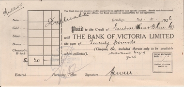 Bendigo Historical Society Inc.
Administrative record - Bank of Victoria credit for Central Red, White and Blue Gold Mine, 1917 - 1920
Bank of Victoria Limited (1852 - 1927) From 1852 Melbourne, Victoria To 1927 Registered in Victoria in 1852 by an Act of the Legislative Council, the company commenced operations in January 1853 as the Bank of Victoria. In 1889 the business was registered under the Victorian Companies Act and became known as the Bank of Victoria Limited. 1927 saw the company merge with the Commercial Banking Company of Sydney Ltd. https://www.gabr.net.au/biogs/ABE0224b.htm (Guide to Australian Business Records) The Bank of Victoria, Sandhurst, was in View Street on the corner adjoining Rosalind Park. Pay-in slip for gold bullion lodged with the Bank of Victoria Limited to the value of 'twenty pounds', dated 24th May 1926. Written across pay-in slip if 'bullion' on the top left hand corner, and 'duplicate' written broadly across the document. bendigo, margaret roberts, , goldmining, central red white and blue gold mine, bullion, gold, bank of victoria limited -
 Lakes Entrance Historical Society
Photograph - View from Central Hotel Tower, Redman, George, 1950c
Black and white photograph, taken from spotting tower showing Central Hotel, with advertising sign for Buchan Caves, parked cars of the era. Lakes Entrance Victoriahotels, township, vehicles -
 Stawell Historical Society Inc
Photograph, Stawell Central Cafe photos. Main Street Stawell
-1 Boy James Cavans (Kavarnos) in front of Stawell Central Cafe c1951 -2 Delivery truck P Cavans in front of cafe. Driver unknown, boy James Cavans (Kavarnos), owner Peter Cavans (Kavarnos) -3 Family group left to Right c1951-1954, Irene Cavans (Kavarnos), James Cavans (Kavarnos), Peter Cavans (Kavarnos), Mary Tsimnadis (Daughter of Anna Trimnadis, Ann TTsimnadis (sister of Irene Cavanas. Three photographs. Truck parked in front of Cafe. Boy in doorway. Family Group.retail shops