Showing 18613 items matching "coloured"
-
 Halls Gap & Grampians Historical Society
Photograph - Coloured, C 1900
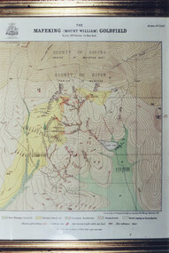
Colour photo of framed map of Mafeking Goldfield.mining, mafeking, maps -
 Halls Gap & Grampians Historical Society
Map - Coloured
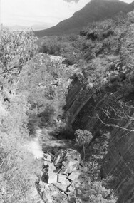
Background on Bridle Path up Stony Creek Gorge Pre 1840 C. B. Hall, squatter on Mokepilly Run 1841-1842, first European to discover the Fyans Creek valley, the entrance of which became known as Hall's Gap. He later recorded that he followed a number of tracks which he assumed had been made by the Aboriginies and described one as "leading up a wild romantic glen and over on to the source of the Glenelg River". This could well have been the route taken up Stony Creek gorge by the first timber-cutters in this part of the Grampians to the saddle between the Wonderland and Mt. Difficult ranges known as Valley Gap 1850s/60s Timber cutters and shingle splitters were reported to be moving into the eastern side of the Grampians and by the mid 1860s there were a number of families connected to the supplying of timber to Pleasant Creek living in the "Hall's Gap ranges". John Wakeham, the first store owner in Pleasant Creek in 1854, established a timer-mill in upper Stony Creek Gorge in the late 1850s. Wakeham is credited for the clearing and levelling of the first bridle-path up the gorge. 1870s By the mid 1870s the track had been extended over Valley Gap to the Victoria Forest (the upper region of the Victoria Valley). McKeon's bullock team was known to have hauled red gum from the Valley to Stawell in the late 1870s and the 1880s. 1880s In 1887 an article in the Pleasant Creek news describes the Stony Creek Gorge track as "being a ledge alongside the mountain range, formed in the early days with the aid of earth and timber, along which the bullock teams used to travel to Horsham and plains of the Wimmera beyond." 1890s Gold was discovered in the catchment area of Stony Creek and by the end of the 1890s a new track was built from "near the junction of Fyan's and Stony Creeks, up the gorge to the diggings settlement. The mining Department had paid L300 for its construction and, when completed, the track was "three miles and 30 chains in length, the side cuttings at the narrowest part being 10 feet between" and "the watercourses which cross the track at various points" having been "filled up with rocks rolled down the sides of the hills, and consequently there can be no damage caused by bushfires which destroyed the former wooden bridges erected on the old track to Wakeham's saw-mill, the remains of which are still to be seen at the side of the diggings" The article goes on to further describe the track as one which "can with ease travel with a two horse conveyance either up or down" and that the workmen engaged in the construction of the track would be attending "a ball that night at McKeon's farm near the mouth of the gap to celebrate the successful completion of the undertaking". 1900s At what time the bridle path was extended beyond Valley Gap to the Wartook basin on the Mt. Difficult Range has not yet been determined. However, it is known that, by the turn of the century, people were travelling between Halls Gap and the caretakers' residence at Wartook Reservoir along what was now known as the "Bluff Road. Wartook's embankment had been constructed in 1887 and at that time there was already a track from Rosebrook Station homestead (near the present day Wartook Pottery) to the reservoir. Philip Rose owned both Rosebrook and Wartook Stations from the mid 1840s to the late 1850s and had regularly leased the Wartook basin to Cobb & Co. to rest horses there. 1920s Following the war of 1914-1918, tourism really took off in the Grampians, and Halls Gap rapidly grew. People would travel as far as they could on the many tracks then hike to the many lookouts being discovered by local tour guides. This led to the need for access across the range so that horse riders and the increasing number of vehicles could travel between Horsham and Halls Gap. To this end, the Bluff Road was improved and extended on 1929 and at its opening in March, 1930, by Lady Somers it was renamed the Mt. Victory Road.Map of Mt Victory Road and othersaccess routes, mt victory rd, bridle path, roads -
 Halls Gap & Grampians Historical Society
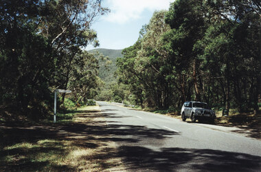
Photograph - Coloured, 1998
Photo shows car parked at side of the road at Wannon Campground, looking north on the Halls Gap - Dunkeld Road.access routes, chalets -
 Halls Gap & Grampians Historical Society
Photograph - Coloured
Photo of Robert (Bob) Anderson.Colour photo of a man, close-up of head and shoulders.people, anderson -
 Halls Gap & Grampians Historical Society
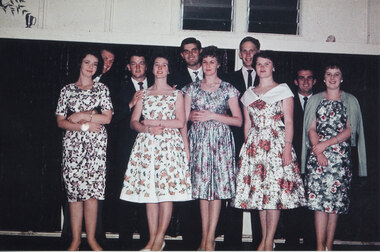
Photograph - Coloured, 05/03/1960
Photo taken at Graeme Chappell's 21st birthday. From left to right: Doreen Eaton & Jack Deller, Doug Bottoms & Bev ?, Graeme Chappell & Kathy Penrose, Doug Leibert & Kaye Penrose, Darryl Williams & ?.Photo shows a group of people, five men and five women, taken at a twenty-first birthday party at Pomonal Hall.peoplerecreation, entertainment -
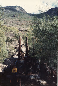
 Halls Gap & Grampians Historical Society
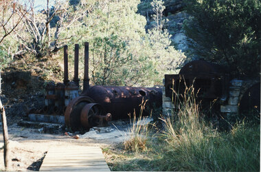
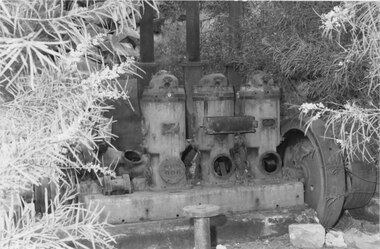
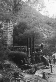
Photograph - Coloured, C 1960s (?)
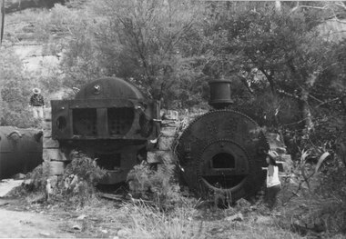
Photo shows steam-boiler equipment left to middle of photo. Three iron chimneys stand above and to the left of the boiler. Another boiler is supported by stone blocks on the right of the photo. A section of board-walk appears in the bottom left.quarrying, heatherlie -
 Halls Gap & Grampians Historical Society
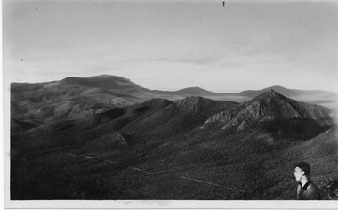
Postcard - Coloured, C 1950s
This photo is of an unknown location in the Grampians.Photo shows a range of hills. The head and shoulders of young man can be seen in the bottom right hand cornerPost Card Correspondence, Address only Kodak Autraliascenery, grampians ranges -
 Halls Gap & Grampians Historical Society
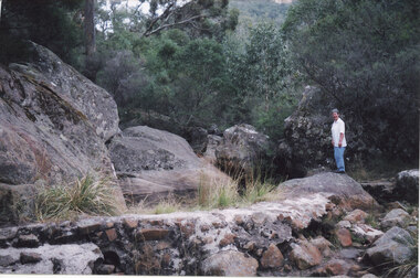
Photograph - Coloured, 24/04/2005
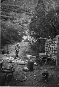
The photo shows a small weir on the Stoney Creek which used to supply water to a number of early businesses in Halls Gap, such as the general store and Grampians House. Each business ran a pipe from the weir to their premises and three outlets can still be seen embedded in the wall. Record 248 was taken at the same time.Photograph of a woman approaching a small weir with three large boulders behind it. The original level of the weir can be seen on the boulders. The additional image is a description of how to get to the weir.scenery, stoney creek -
 Halls Gap & Grampians Historical Society
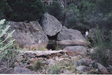
Photograph - Coloured, 24/04/2005
The photo shows a small weir on the Stoney Creek which used to supply water to a number of early businesses in Halls Gap. The weir's former level can be seen on the large rocks behind but once a town water supply was installed, the wall of the weir was breached. Record 247 was taken at the same time and includes an image of a description of how to get to the weir.Photograph of a woman approaching standingh on a rock near a small weir. There are large boulders behind it which show the former level of the weir.scenery, stoney creek -
 Halls Gap & Grampians Historical Society
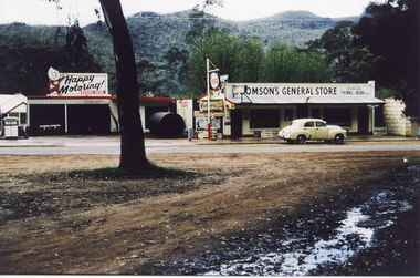
Photograph - Coloured, C 1960
The second general store in Halls Gap, built by Jack and Clarrie Thomson. Halls Gap newsagency now (2009) stands on this site. Probably taken at the same time as record 253 (as the yellow car appears to be in the same spot).The photo shows a garage and a general store. There is an Esso sign in front of the buildings and the store sign reads Thomson's general Store. There is a bitumen road, with a yellow early model Holden parked on it, in front of the store. The Mount Willliam range in the background. There appears to be snow or hail lying on the ground in the foreground.buildings, shops -
 Halls Gap & Grampians Historical Society
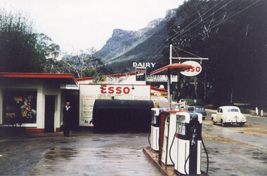
Photograph - Coloured, C 1960
The proprietor standing in front of the Esso garage. Probably taken at the same time as record 252 (as the yellow car appears to be in the same spot).Photo shows a man standing in front of an Esso garage building. There are petrol pumps in the foreground. A yellow early model Holden and a blue station wagon are parked on the road in the right of the Picture. General Store and Dairy signs can be seen behind the garage and the Wonderland Range can be seen in the background.buildings, shops -
 Halls Gap & Grampians Historical Society
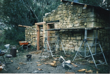
Photograph - Coloured, C 2000s
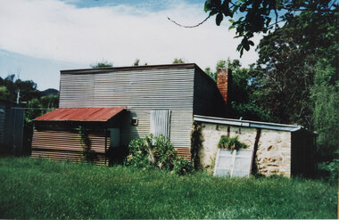
This is the building that was used as a bakery in the 1940s.A galvanised iron structure with a lower stone outbuilding at the side and a rusting galvanised iron lean-to at the front. The building has a brick chimney and an old, white window is leaning against the front of the stone portion of the building.buildings, bakery -
 Halls Gap & Grampians Historical Society
Photograph - Coloured, C 1980s (?)
quarrying, mt difficult quarry -
 Halls Gap & Grampians Historical Society
Photograph - Coloured, C 1980s (?)
quarrying, heatherlie -
 Halls Gap & Grampians Historical Society
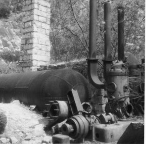
Photograph - Coloured, C 1980s (?)
Photo shows close up view of steam equipment. Three iron chimneys attached to equipment are cut off from view at top of photo. Wattle in bloom can be seen on both sides of photo.quarrying, heatherlie -
 Halls Gap & Grampians Historical Society
Photograph - Coloured, 1956
Old buildings. The Quarry. Roses Gap Rd.quarrying, mt difficult quarry, buildings, heatherlie -
 Halls Gap & Grampians Historical Society
Photograph - Coloured, C 1960s (?)
Stone was transported out of quarry by rail. Some sections of track are still visible at the Quarry.structures, train tracks, quarrying, mt difficult quarry -
 Halls Gap & Grampians Historical Society
Photograph - Coloured, C 1960s (?)
quarrying, heatherlie -
 Halls Gap & Grampians Historical Society
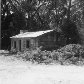
Photograph - Coloured, C 1960s (?)
buildings, houses -
 Halls Gap & Grampians Historical Society
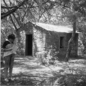
Photograph - Coloured, C 1960s (?)
buildings, houses -
 Halls Gap & Grampians Historical Society
Photograph - Coloured, C 1960s (?)
buildings, houses -
 Halls Gap & Grampians Historical Society
Photograph - Coloured, C 1960s (?)
This paper manufactured by Kodakbuildings, houses -
 Halls Gap & Grampians Historical Society
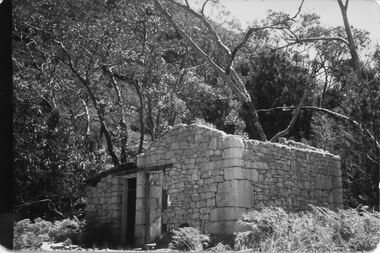
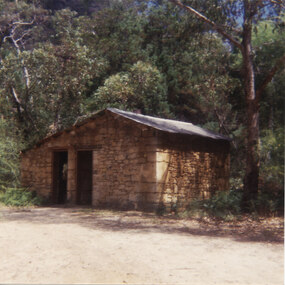
Photograph - Coloured, C 1960s (?)
Stone-mason's hut. Heatherlie Quarry.buildings, houses -
 Halls Gap & Grampians Historical Society
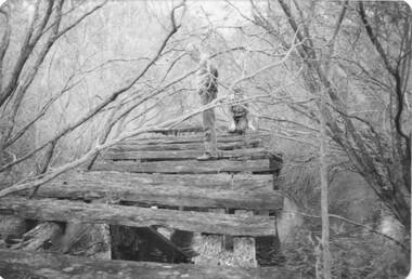
Photograph - Coloured, C 1980s (?)
Photo shows old wooden rail bridge curved up and over a creek. A man is standing on bridge looking down, a woman is kneeling behind man and is also looking down. Tree branches are leaning over bridge.'Old rail bridge"structures, bridges, trains -
 Halls Gap & Grampians Historical Society
Photograph - Coloured, C 1980s (?)
quarrying, mt difficult quarry -
 Halls Gap & Grampians Historical Society
Photograph - Coloured, C 1960s (?)
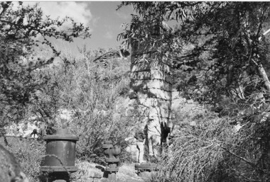
Photo shows steam boiler equipment. Stone chimneys feature in middle of photo. Quarry rockface ^& bushes in background. 'Blurred' leaves appear in bottom right corner.H/GAP0612 NANNAquarrying, mt difficult quarry -
 Halls Gap & Grampians Historical Society
Photograph - Coloured, C 1960s (?)
Photo shows close-up view of steam boiler equipment. Stone chimney is also visible, however because of close-up view top of chimney cannot be seen. Wattle tree in bloom is visible in top right corner.quarrying, heatherlie -
 Halls Gap & Grampians Historical Society
Photograph - Coloured, C 1960s (?)
Photo shows steam equipment with three iron chimneys attached. A boy and girl are sitting on equipment. View of large rocks, rock face and top of range in the background. Both children are in shadow.quarrying, heatherlie -
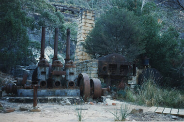 Halls Gap & Grampians Historical Society
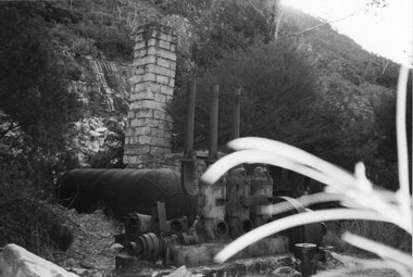
Photograph - Coloured, C 1960s
Photo shows steam boiler equipment. Three iron chimneys appear to the left of the photo. A stone chimney stands in middle of photo nand to back of equipment. A second boiler is encased by stone blocks. A section of boardwalk appears in right front of photo.quarrying, heatherlie -
 Halls Gap & Grampians Historical Society
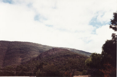
Photograph - Coloured
This is a photo of Maggie's Peak, where Chautauqua picnics were held. This peak overlooked the are in Halls Gap where the concerts were held.A photo of a small peak with a rocky cliff near the summit and a larger hill rising behind. There is a edge of a large tree visible in the right foreground.scenery, grampians ranges