Showing 1084 items matching "coloured view"
-
 Hume City Civic Collection
Photograph, early 1980s
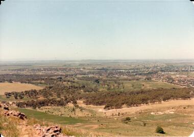
The Headland Estate housing development began in the early 1980s. It was situated west of Sunbury and was bounded by Elizabeth Drive, Reservoir Road, Phillip Drive and Stewart's Lane.A coloured landscape photograph with rounded corners of a view of Sunbury overlooking the Headland Estate before its development. There is a rocky outcrop on the LHS of the photograph and a lightly timbered area in the middle distance. Sunbury can be seen in the distance.headland estate, mt. holden, sunbury township, george evans collection -
 Hume City Civic Collection
Photograph, early 1980s
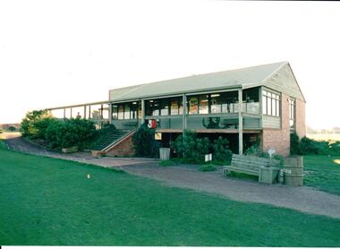
The series of photographs were taken shortly after the opening of the newly established Goona Warra Golf Club in the early 1980s. The golf club was part of the Goonawarra Housing Estate which was developed on the area previously known as Goonawarra Farm. The new golf club replaced 'The Pines' which was part of the Caloola complex.A coloured photograph of the front view of Goonawarra Golf Club's clubrooms. The building is on 2 levels with a large balcony across the front. Native plants have been planted around the building and a gravel path leads to the building.goona warra golf club, george evans collection -
 Stawell Historical Society Inc
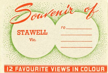
Postcard, Front Cover of 12 Stawell and District Views as Souvenir Booklet -- Postcard -- Coloured
Twelve Stawell and District Souvenir Bookletsstawell -
 Stawell Historical Society Inc
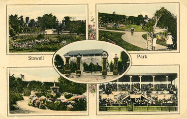
Photograph, Stawell District Views --3 Photos -- Postcards -- Colourised
Stawell District (3 Coloured Postcards)stawell -
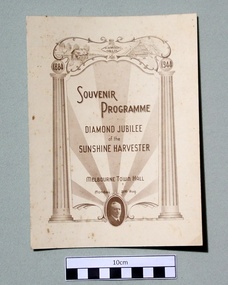 Sunshine and District Historical Society Incorporated
Souvenir Programme (1944), DIAMOND JUBILEE celebration of the SUNSHINE HARVESTER, 1944
As a youth while working on his father's farm, Hugh Victor McKay became tired of the labour involved in winnowing wheat by hand. In 1884 he built the first machine in the world which did the winnowing in conjunction with the reaping. On Monday 21st August 1944, which coincided with the birthday of the late H. V. McKay, more than 2000 employees and friends of H. V. McKay Massey Harris Pty Ltd were entertained at the Melbourne Town Hall, in celebration of the Diamond Jubilee of the Sunshine Harvester Works.The event was planned to "turn it on for the boys' in a manner befitting the occasion." The compere was Eric Pearce (of later TV newsreader fame) and the entertainment was provided by leading performers of song (W.M.Laird and Mary Miller), of music (John Robertson, W.M.King, and the Sunshine Brass Band), and of humour (Charles Sherman). The accompanists for some of the performances were Betty Miller and Eric Fox. Two films depicting the activities of the Sunshine Works were shown, and the managing director Mr C. N. McKay, was presented with a book by Mr Fred Bult who had 50 years service with the company. The book contained more than 1000 signatures from invited employees who had completed more than 10 years of service, Supper was provided in the Lower Hall, and the MC for dancing to the Synco-Harvesters Dance Band in the Main Hall was James Patrick. The committee which organised the function were Messrs. L.W. King (Chairman), G. Baker, J. Downing, R. Stewart, F. J. Lee, V. Armstrong, F. Fields, J. Aird, G. Wilson, J. G. McKay, T. N. McArthur, and R. Webb, with secretaries Messrs. G. Shaw and D. J. McKay. The above information was compiled from the Souvenir Programme, and from The Argus of Tuesday 22 August 1944 which can be viewed at http://nla.gov.au/nla.news-article11357700, and from the Sunshine Advocate of Friday 30 June 1944.The Souvenir Programme provides a historical record of how the Diamond Jubilee was celebrated, as well as the type of entertainment and the names of the entertainers and other people involved. It also lists the types of dances such as the 'Fox Trot' and the 'Pride of Erin' that were normal entertainment in 1944. The Souvenir Programme is also significant in what it does not tell us. There is absolutely no indication of what would be considered to be a supper for an event like this in 1944, especially in the Melbourne Town Hall. From a historical point of view it would be interesting to know.Beige coloured cardboard document which is folded in two, and has brown coloured printing on three of the four sides. The document provides a detailed list of the entertainment and the presentations held in the Melbourne Town Hall, to celebrate the Diamond Jubilee of the Sunshine Harvester Works.1884 1944 / SOUVENIR PROGRAMME / DIAMOND JUBILEE of the SUNSHINE HARVESTER / MELBOURNE TOWN HALL / Monday 21st Aug.sunshine harvester, diamond jubilee, h. v. mckay, massey harris pty ltd, 21 august 1944, 1884, 1944, melbourne town hall, sunshine harvester works, sunshine harvester, diamond jubilee, h. v. mckay, massey harris pty ltd, 21 august 1944, 1884, 1944, melbourne town hall, sunshine harvester works -
 Stawell Historical Society Inc
Photograph, Pioneers’ Memorial and Plaques on Big Hill --3 Photos -- Coloured
Three colour photographs, one view of Pioneers Memorial and two of the stone plaques. The memorial photo looks freshly painted. The plaques illustrate that the foundation stone was laid by Lord Huntingfield in c 1935 while the other plaque is dedicated to the Pioneers of Stawell and Districts in c 1938. Three colour photographs, one view of Pioneers Memorial and two of the stone plaques. The view of the memorial looks crisp and clear with a dark cloudy background. A Ute is parked in the background beside the light post. "Stawell Gold mines" on the back of the 3 photographs. Wording on plaques "This Foundation Stone was laid by HIS EXCELLENCY LORD HUNTINGFIELD, K.C.M.G. Governor of Victoria October 7th, 1935. The second plaque "Dedicated to the Pioneers of Stawell and District by HIS EXCELLENCY SIR FREDERICK WOLLASTON MANN K.C.M.G. Lieut Governor of Victoria. August 6th, 1938.stawell -
 Stawell Historical Society Inc
Photograph, Wooden Home at no.1 Seaby Street -- Coloured photo
Home in Seaby Street no.1 next to railway line. Built by Luke Kinsella about c 1870. Photo taken March 1992 about time of sale. A series of nine coloured photos in Album 8. p 37-42 of the Seaby house and interior. Photos in album 8 show 3 different views of the side of the building. One of the wood paneling in the entrance hall. Also 3 photos of the mantlepieces and cast iron grates in the fireplace. Luke Kinsella, brother to Thomas Kinsella's (part owner of Magdala cum Moonlight mine). Thomas was the eldest of the boys then Luke and John Kinsella the youngest. Home in Seaby Street no.1 next to railway line. Built by Luke Kinsella about c 1870. Colour photograph. Series of 9 photos in Album 8. p37-42.stawell dwellings -
 Stawell Historical Society Inc
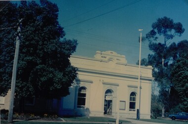
Photograph, Stawell Shire Hall 1866 c1980s -- Coloured
Colour Photo Stawell Shire Hall built 1866, c1980. The Shire Hall is in Longfield Street Stawell and has had many changes since 1866. Ronald Campbell, the Shire's second president laid the foundation of the hall on 28th April 1866. The contractors were Hutchings and Delbridge. The first Hall and office were the front part of the existing building. These rooms consisted of two 18 ft square rooms with an entrance hall separating them. The facade was almost the same as it is today. The building cost 502 pounds.Colour photograph of Stawell Shire Hall 1866. Very similar view to 0084 the photo clearly showing the two windows and arched entrance door. Landscaping outside the building is exactly the same as in 0084. stawell -
 Stawell Historical Society Inc
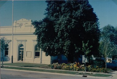
Photograph, Stawell Shire Hall 1866 -- Coloured
View of the Stawell Shire Hall from the road way. The photo does not show the decorative fence around the front of the building as show in the previous photograph. Coloured photograph of the Stawell Shire Hall. A telegraph pole in front of a large tree can be seen on the left hand side with a flag post out the front of the building. There is no fence around the Shire Hall. stawell -
 Stawell Historical Society Inc
Photograph, Stawell Shire Hall -- Coloured
Stawell Shire Hall photograph taken around the same time as 84.13. Image shows the building painted white with no decorative fence out the front.View from the street of Stawell Shire Hall. The image is taken from the right hand side of the building showing a colourful flower bed in front of a large tree. The flag post is also out the front of the Shire Hall. stawell -
 Stawell Historical Society Inc
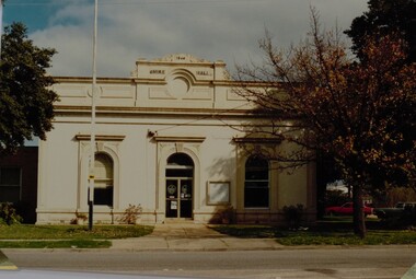
Photograph, Stawell Shire Hall 1866 c1988 -- Coloured
Photograph of Stawell Shire Hall taken 1988. 1988 view of the Stawell Shire Hall. Photo taken from the other side of the road. The decoration on top of the building is missing. The tree on the right hand side is losing its leaves and 2 cars are parked on the right, behind the tree. Stawell Shire Hall 1988 Geoff Oates P.O. Box 402 Stawell.stawell -
 Stawell Historical Society Inc
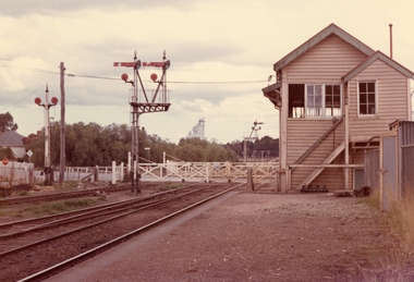
Photograph, Railway Signal Box No.1 and Signal No 2 Railway Gates -- 2 Coloured photos
Colour photo of No1 Signal Box and Railway Gates Seaby Street also called Signal box a. 153.5b is No 2 Signal Box. c 1974Two coloured photographs, 153.3 no.1 Signal box and railway gates. Second photo 153.5b is a front view of no. 2 Signal box. Second photo has Napier & Victoria St in background. Note rail line is closer to signal box in 153.5 b, second photo and stairs are different. Vac 74 no1 Signal box and signal gates (153.5) Vac No 2 Signal box (153.5 b)stawell -
 Stawell Historical Society Inc
Photograph, Railway Station Stawell viewed from Napier Street 1988 -- 2 Photos -- Coloured, Sept 8 1988 & Dec 1974
Two colour photos of Stawell Railway Station. View from Napier Street 1988.2 Coloured Photgraphs of Stawell Railway station looking WestLarger Photo: On the back in blue Ink. Stawell Station Sept 8 1988 Small Photo: In a Yellow Diamond "Pedestrians" on the back Dec 24 Stawell Station St.stawell railways transport -
 Stawell Historical Society Inc
Photograph - Large Print, Aerial View of Pleasant Creek Training Centre and North Western Woolen Mills, c1975
Taken when buildings were at their peak. Referred to as Pleasant Creek Training Centre or Pleasant Creek Special SchoolMainly yellow coloured with Pleasant Creek Training Centre in middle and with Stawell North Western Woolen Mills at top right.VIC 25996 A1x10.3 QASCO VIC IMAGE 03 9682 3330education, manufacturing -
 Stawell Historical Society Inc
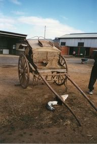
Photograph, Newton’s Butchers Cart -- 3 Photos -- Coloured
Newton’s Butchers Cart. Three photographs showing different views of the butchers cart. The photographs were taken at Dadswells Bridge, Stawell. The photo 61 shows the front view of cart. Photo 61.1 is the back view of the cart. The third photo 61.2 is of Hartley Newton standing by the butchers cart. The faded writing on the side of the cart (61.1) is "Butchers" and "Patrick St Stawell" (on the back).Three coloured photos of Newton's butchers cart. The photo 61 taken of the front view of cart. Photo 61.1 is the back view of the cart. The third photo 61.2 is of Hartley Newton standing by the butchers cart.The faded writing on the side of the cart (61.1) is "Butchers" and "Patrick St Stawell" (on the back).stawell -
 Stawell Historical Society Inc
Photograph, Armstrong’s Area Houses c 1990's -- 2 Photos -- Coloured
Residence Fountainhead Brewery Armstrong's Est. c 1872. The rear view photograph shows a more recent renovated building. Some evidence of demolition to rear of building (servants stairs etc.) Following notes taken from information in album 9 - "Compare earlier photos and note balcony etc. Later views, This photo early 2003. Owing to timber decay balcony was removed for safety. Finances permitting complete balcony will be replaced. Twin columns and iron lace are not original. Early description mentions statues in "niches" beside door. Female statue left is original. White pedestal at left was male stature damaged by a falling tree. Both statues were fountains." Photographs taken by Mr. Don Richard and held in Album 9b Armstrong’s Area.Two coloured photographs, of a brick double story building. The front view of the building has 4 windows and 2 doors. Two white columns at the entrance with decorative iron work support the roof of the porch with 2 white chairs and a table on top. Either side of the entrance door are 2 white wall indents "niches" with pot plants. The second photo show the back view of the two story building with a single story building attached that has a tin roof. A timber fence with a gate shows the side entrance to the single story building. 648M NHNN 8H01HPRO3 WIMMERA 1MHGINGstawell -
 Stawell Historical Society Inc
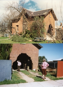
Photograph, Police Superintendent’s Horse Stables -- 2 Photos -- Coloured
Police Superintendent’s Horse Stables. Photos showing the hole in the back wall. People in the second photo from left to right are Gillian Walker, Alan Kingston, Geoff Austin (Heritage Vic.) and Dorothy King. The top photo was taken in 1988. The bottom photo a side view from Griffiths St taken in 1999.Colour photos of red brick building, once Police Superintendent's Horse stables. First photo shows the building with holes in the roof and a large hole in the back wall. The other photo shows the back wall where bricks were removed in the 1950-60s. This second photo shows four people looking at the hole in the wall. (Also, 3 photos in Album 13 p 64 taken 04.03.2004)Stawell 1988 Geoff Oates P.O. Box 402 Stawell.stawell -
 Stawell Historical Society Inc
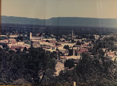
Photograph, Panorama of Stawell from Big Hill -- Coloured
Colour Laminated photograph and timber framed view of Stawell from Big Hill. c 1998 The Town Hall is at the center of photograph and the National Hotel on the left. The back of buildings can be seen at top of Main Street. Laminated and Framed photograph taken by Irene Read in c 1998 showing view of Stawell from Big Hill -- The Coloured photograph can be identified by trees in the foreground, Stawell township and mountains in background.stawell, panorama, streetscape -
 Stawell Historical Society Inc
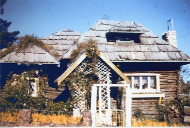
Photograph, Log Cabin c 1930's -- Coloured
Colour photo Log Cabin built by J Wharrie during 1930s. The photo was taken from a colour slide from Allan Howells Collection. Photo taken c 1960 -70.Log Cabin built by Mr. J. Wharrie during the 1930's. This photo is a front view of the house with vine growing over the porch and bark roof. A weather vane can be just made out on the roof. stawell dwelling -
 Stawell Historical Society Inc
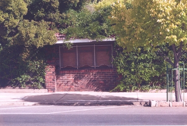
Photograph, Brick Ticket Box at Central Park on left side of the Main gate -- Coloured
Brick Ticket Box on left side of main gate at Central Park. Both photos are of the same view of the ticket box. The other photo does not includes the street tree.Brick Ticket Box on the left side of the main gates at Central Park. This is one of two photos in album 3, both of the same view.stawell central park -
 Stawell Historical Society Inc
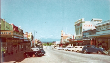
Photograph, Main Street Stawell looking West with Geo. Mitchell shop on the right c 1955 -- Coloured
Coloured photo c 1955 Main Street Scene looking West. Geo Mitchell Draper on right with Coles and Macrows. On the left E. Dale & Co. shop sign is visible. Either side of the street has cars parked at an angle with a soft canopy car parked on the left side.Colour photograph looking down Main St Stawell with the Grampians in the distance c 1955. This coloured photo has shops either side in view and cars parked at an angle along the street. Coles, Macrows and Geo. Mitchell shops are on the right and E. Dale & Co shop sigh is visible on the left.stawell business streetscape -
 Stawell Historical Society Inc
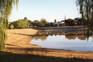
Photograph, Cato Lake looking from Sloane Street -- Coloured
Cato Lake view from Sloane Street. This photo is one of three showing Stawell Council Works deepening Cato Lake in February c 2002. Tracks from a tractor can be seen all round the lake. Willows branches hang either side of the view with trees along the horizon. The Presbyterian Church tower, Senior Citizen room and Anglican Church can be seen amongst the trees in the background.Coloured photograph of Cato Lake. The view is from Sloane Street and the lake was in the process of being lowered for the deepening of the lake by Shire Council Works. Tractor tracks can be seen all round the lake. Willows hang either side of the view with trees along the horizon. The Presbyterian Church tower in the background near the Senior Citizen room and Anglican Church to the right.Date on back of photo in biro 12.2.2002.stawell -
 Stawell Historical Society Inc
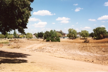
Photograph, Cato Lake looking from Viictoria Street -- Coloured
Cato Lake view from Victoria Street looking towards Sloane Street. This view shows the emptying of the lake carried out in c 2002 for deepening the lake by Shire Council Works. This view shows a tractor working around the empty lake. Coloured photograph of emptied Cato Lake from Victoria Street side looking towards Sloane Street. The lake was emptied in c 2002 for deepening by Shire Council Works. This view shows a tractor working around the emptied lake. In the background are trees with houses amounts them.Written in biro 5.2.2002stawell -
 Stawell Historical Society Inc
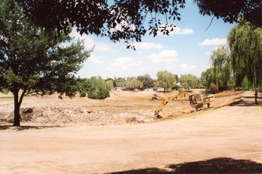
Photograph, Cato Lake looking from Victoria Street -- Coloured
View of Cato Lake showing the excavation of the lake. Photo taken from Victoria Street, rear of Napier Street residences. The excavation of the lake was to increase its depth and a excavator and bulldozer can be seen working the ground. Willow trees are to the right in the photo.Coloured photograph of the deepening of Cato Lake in c 2002. This view is from Victoria Street, rear of Napier residences. In this photo an excavator is removing dirt with a bulldozer in the background. 5.2.2002 (written in biro).stawell -
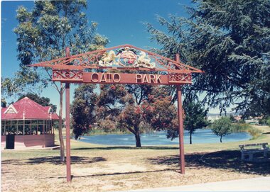
 Stawell Historical Society Inc
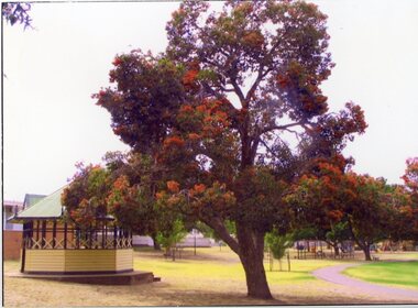
Photograph, Cato Park Flame Tree playground c 1995 -- 2 Photos -- Coloured
2 Colour Photos Gateway, Flame Tree and Playground in Cato lake c 1985. This area was once the gateway to Cato lake but later moved. Both photos are near the lake as can be seen in 67.18a which has a view of the playground in the distance.Two colour photographs, one of the Gateway flame tree. the other a view of the edge of the lake with the playground in the distance. The flame tree in 67.18 shows the flame tree in flower beside the rotunda. The other photo 67.8a is a view of the edge of Cato lake with the playground in the background behind a group of trees. stawell -
 Stawell Historical Society Inc
Photograph, Cato Park -- Ornately Decorated Entrance -- 2 Photos -- Coloured
Two colour photo of Cato Park ornamental entrance gate that replaced the old entrance gates in c 1930's. The new entrance gates were donated by Mr. Frederick Cato and the park renamed from Victoria Park to Cato Park. The coat of Arms over the entrance gate was donated to Stawell Borough Council in 1926 by Mr. P. Whelan a native of Stawell. Mr. Whelan or better known as "Whelan the wrecker" demolished more than a quarter of central Melbourne buildings so new buildings could be erected on the old sites. The coat of arms came from "Burke & Wills Building" that once stood on the corner of Russell & Collins Street Melbourne. Two colour photographs of Cato Park ornamental entrance gate. Both photos are of similar views with the lake in the background and rotunda behind the gate. The main difference between the two photos is the colour of the rotunda roof, one red the other green. Judging by the increase in tree growth and pathway under the entrance gate the photo with the green rotunda roof must be the more recent photograph. stawell -
 Stawell Historical Society Inc
Photograph, Panorama of Stawell from Big Hill -- Sunset -- Coloured
Sunset from Big Hill. The photo shows the Stawell township with the Grampians in the background and the sun setting behind the Grampians. The majority of the image is a view of the cloud formation. Photo taken by Carol Anne JonesColour photograph of sunset from Big Hill. The photo shows the Stawell township with the sun setting behind the Grampians. The majority of the image is a view of the cloud formation.Carol Anne Jonesstawell -
 Stawell Historical Society Inc
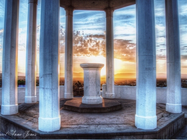
Photograph, Pioneers Memorial on Big Hill -- Sunset through its Columns -- Coloured
Looking through Pioneers Memorial Columns. The photo shows the ground floor of the Pioneers memorial with the Corinthian pillars supporting the dome. The directional pedestal is in the center installed in c 1947. The Stawell township is in the background with the sun setting behind the Grampians.Looking through Pioneers Memorial Columns with the directional pedestal in the center. The view shows the Stawell township in the background and the sun setting behind the Grampians.Carol Anne Jonesstawell -
 Stawell Historical Society Inc
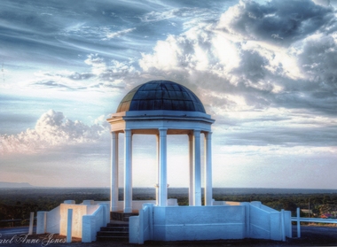
Photograph, Pioneer Memorial on Big Hill looking North West -- Coloured
Pioneer Memorial looking Northwest with a spectacular sky background. The foundation stone of the memorial was laid in c 1935.Colour photograph of the magnificent Pioneers Memorial on Big Hill. View is looking toward the Northwest just showing the edge of the Grampians. Photo shows the memorial with a spectacular sky background.Carol Anne Jonesstawell -
 Latrobe Regional Gallery
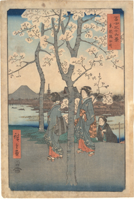
Print, HIROSHIGE, Utagawa, No. 7 From Sumida River from series "36 Views of Mt.Fuji", c. 1858 (Year of the Horse 4)
Edo PeriodColoured woodblock printmt.fuji, sumida river