Showing 7567 items matching "d"
-
 Bendigo Military Museum
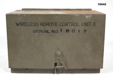
Equipment - WIRELESS REMOTE CONTROL UNIT, Stromberg-Carlson, 1941
Heavy cast Aluminium box with hinged lid. Colour is drab olive. Each end has a belt loop. There is a semi rotating clip on the front of the lid section to hold it shut. Inside are Morse Key, 3 switches, Buzzer Assembly, 3 terminals and a built in battery box. Inside the lid are the circuits for the device and operating instructions. On lid is stamped 'D^D'. On front is "Wireless Remote Control Unit A, Serial No. 18017. Inside is marked serial 18017. Inside on Battery cover is: - “Wireless Remote Control Units 'A'./ Stromberg Carlson Serial No....... 1941” Inside on front panel is :- “Serial No. 18017/ D^D Vac No. ZA 7533".wireless remote control unit, signals, army, morse code -
 Mont De Lancey
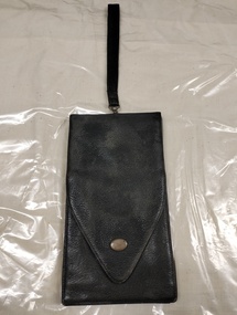
Accessory - Leather Wallet, 1913
Design very similar to the sabretache, popularly hung from the belt by military personal from 18th to late 19th century. Very probably used, like sabretaches, to hold documents and notebooks in addition to money. Handwritten notes on the wallet indicate that it was owned by a D. Clarke in South Melbourne, given to him in 1913 by a friend.Long black leather bag closed with envelope flap and push closure. Has a wrist strap handle attached to the centre with a circular d-ring. Lined with purple silk taffeta. Contains a small rectangular notes and coin purse attached to the top. Purse also closes with an envelope flap and push closure. Purse has two sections, one for note and one for coins, separated by a divider. Bottom has an open accordion pouch with two sections for a pocket book.Written on inside in pen: "From Link Fo-[?] // 1913" On the inside of the purse's flap: "D. Clarke // 94 Market St // South Melb"wallet, leather, 1910s, 1913, south melbourne, sabretache, mens bags, pocketbook, menswear -
 Bendigo Historical Society Inc.
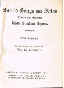
Book - ALEC H CHISHOLM COLLECTION: BOOK ''SACRED SONGS & SOLOS''
Book. ALEC H CHISHOLM COLLECTION. Small soft cover book of 1200 Sacred Songs and Solos, revised and enlarged with standard hymns. Compiled under the direction of Ira D. Sankey. Date unknown, perhaps early 1900s. Published by Morgan, Marshall & Scott Ltd., London and Edinburgh. Printed by R W. Simpson Co. Ltd., London. Catalogue sticker ''2207 SAN''.Ira D Sankeybooks, collections, songs, alec h chisholm collection, ira d sankey, sacred songs, hymns -
 Wangaratta RSL Sub Branch
Equipment - WW2 Telephone Set, Standard Telephone and Cables Pty Ltd, 1942
An example of a Telephone Set D Mk V which was used by Australian forces during the Second World War for verbal and Morse code communications over short distances via a telephone line.An example of a Telephone Set D Mk V which was used by Australian forces during the Second World War for verbal and Morse code communications over short distances via a telephone line. Rectangular aluminum green painted box with broad canvas webbing strap secured to the side of the body through metal loops. Two vertical webbing loops are attached to the rear of the body. Stencilled in black on top TELE. SET. D. MK. V.'. The housing opens by a hinged fold back lid that is secured by a hook and eye closure. Attached to the inside of the lid are two metal plates. The first is a circuitry diagram, the second is the instructions for use of the set. The interior contains the phone assembly and is divided by a metal shelf. On the left is a bell with two screw terminal in front. At the center is the telegraph key and behind that is the battery box with a small metal plate with, 'TELEPHONE SET. D.MK.V To the right is metal box with two terminals in frontAttached to the bottom of the shelf is a slide out metal key Below the shelf is a compartment in which is stowed a black metal headset with provision for a bakelite handset with attached cord and four-prong plug.Tele Set stamped on outside of unit. Inside lid plaque - Telephone Set D MK V -
 Lakes Entrance Historical Society
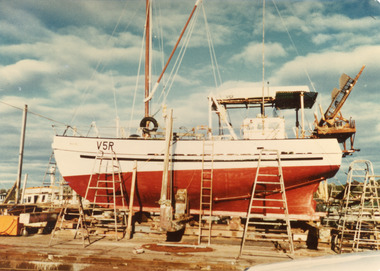
Photograph - Marlene D, 1975c
'Marlene D' owner Brian BoldingColour photograph of a scallop fishing boat on the slips at Eastern Wharf. Name of boat not indicated, registration number V5R but identified as Marlene D. Lakes Entrance Victoriaboats and boating, fishing industry, slipway -
 Rutherglen Historical Society
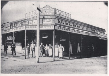
Photograph - Copy of Image
Photocopy of photograph of D. Hamilton, Licensed Grocer Wine and Spirit Merchant, Clydesdale Store, Draper, Outfitter, IronmongerWritten on building above the corner of the store: "D. Hamilton Licensed Grocer Wine & Spirit Merchant, Clydeside Store, Draper, Outfitter, Ironmonger"hamilton family, david hamilton, d g hamilton, hamilton store, clydeside store -
 Stawell Historical Society Inc
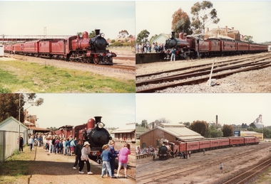
Photograph, Steam Trains at Stawell Station -- 6 photos -- Coloured
Series of 6 photos, Steam train "D", 3 class and passenger carriages at Stawell Station. c 1990Series of 6 colour photographs of Steam Trains & passenger carriages at Stawell Station "D" 3, ?39 unsure of first number.railways -
 Melbourne Tram Museum
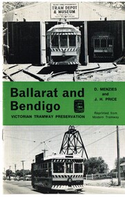
Book, Light Railway Transport League (LRTA), "Ballarat and Bendigo, Victorian Tramway Preservation", 1975
Twelve page booklet, titled "Ballarat and Bendigo, Victorian Tramway Preservation" written by D. Menzies and J.H. Price, reprinted from Modern Tramway. Front cover has BTPS tram 38 on original depot fan, green banner centrally with title, and Bendigo Birney No. 28. A circular white sticker with "1.00" written on is stuck on the right hand side, centrally. Saddle stapled print in black ink on 120gsm art paper. Written material covers background history of both Ballarat and Bendigo tramways, tramcars, closure, the formation of the BTPS and the Bendigo Trust tramways and their operational history up to about mid 1975 as it mentions the first COTMA meeting. Also has 12 photos inside. On rear cover is an advertisement for the TMSV and the Light Railway Transport League (UK) (LRTL). PDF copy of full book added 16-3-2017."D. W. Lees 2/2/76" on top of page 2 and "D. W. Lees" on side of page 10 in a fine felt pen ink.trams, tramways, ballarat, bendigo, lrtl, tram preservation -
 Bendigo Historical Society Inc.
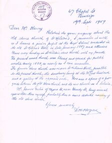
Document - LETTER: DESCRIBING THE OLD STONE CHURCH OF ST. KILIAN, 19/09/1959
Letter describing the old stone church of St. Kilian. From D H Hogan, 67 Chapel St to a Mr Harry (dated 19/9/1959). Writer of the letter was a junior pupil at the boy's School in 1887 and attended mass at the old stone church. Writer describes the position of the church in relation to present church and orientation of the sanctuary (and gallery at the opposite end). Letter is stamped with the RHSV Bendigo Branch stamp, 1959.D H Hoganchurch, history, st. kilian's catholic church, bendigo -
 Hume City Civic Collection
Photograph
A b/w photograph of a group of men. Identified on back as: J. Benson, P. Leydon, Terry O'Brien, Fred Watts, Bill Douglas, D. BranniganHandwritten on back: J.BENSON, P. LEYDON, TERRY O'BRIEN, FRED WATTS, BILL DOUGLASS, D. BRANNIGANbenson, j., leyden, p., o'brien, terry, watts, fred, douglas, bill, brannigan, d., george evans collection -
 National Wool Museum
Certificate, Certificate of Appreciation
Certificate of Appreciation from the Salvation Army, presented to Mr & Mrs R D Pettitt.Appreciation/ presented to / Mr & Mrs R D Pettitt/..salvation army, pettitt, mr r. w. -
Bendigo Historical Society Inc.
Book - FOREST STREET UNITING CHURCH 1853 - 2003
44 page booklet 'Forest Street Uniting Church, Bendigo - 150 years of Worship, Witness and Service'. 1853-2003 Published by The Church Council Forest Street Uniting Church in Australia 2003. Edited by Rod Hamilton and Lawrence D. McIntosh Includes B& W photos and names of council, elders, organists etc.Rod Hamilton & Lawrence D McIntosh -
 Bendigo Military Museum
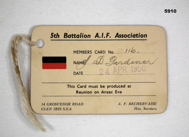
Card - MEMBERSHIP CARD, C. 1950
Item relates to John D Gardiner No 2832, refer Cat No 5892.2 for his service details.Membership card light fawn colour rectangular shape rounded corners, on left is the 5th BN AIF Colour patch followed by the details of the member, card signed in black by the member and stamped in purple re the date, small hole in LH corner with string attached, rear is blank."116 J. D. Gardiner 24 Apr 1950"cards, membership, 5th bn -
 Kew Historical Society Inc
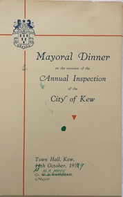
Document (item) - Programme, City of Kew, Mayoral Dinner, 1937
The Municipality of Kew (1860-1863), the Borough of Kew (1863-1910), the Town of Kew (1910-1921) and the City of Kew (1921-1994) were local government instrumentalities in the State of Victoria. In 1994, the City of Kew was amalgamated, together with the former Cities of Camberwell and Hawthorn, into the new City of Boroondara (1994- ). Like other local government entities of the period, Kew was administered by town clerks. The two notable town clerks in Kew's history were H. H. (Henry Hirst) Harrison (1868-1955) and W. D. (William Dickie) Birrell (1899-1974). Harrison was appointed to the position in 1901 and retired in 1938 after 37 years. Birrell, appointed Acting Town Clerk in 1921, became Town Clerk in 1938, following Harrison's retirement. He continued in this role until his retirement in 1966.This card is part of an historically significant civic collection, containing hundreds of separate invitations, documents, greeting cards, programmes and tickets issued and/or collected by successive town clerks. Items in the collection illuminate the political, social and cultural history of the district. As a continuous record, ranging across most decades of the Twentieth Century, they reveal changing tastes in design, values and relationships in the history of local government in Victoria.MAYORAL DINNER/ ON THE OCCASION OF THE / ANNUAL INSPECTION / OF THE / CITY OF KEW / TOWN HALL, KEW / 14TH OCTOBER, 1937 / CR W D VAUGHAN / MAYOR Dates and names later changed in 1939 to 13TH OCTOBER, 1939 / CR H F MOGGcivic invitations -- kew (vic), mayoral dinners -- kew (vic.), w d vaughan -
 Bendigo Historical Society Inc.
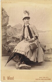
Photograph - HARRIS COLLECTION: FEMALE PHOTO, Nineteenth Century
Black & White photograph D Wood , near Town Hall South Melbourne printed on front of studio portrait. Seaside back drop behind seated young woman. Umbrella, Button up boots, handbag, numerous bangles, peaked hat with tassels, kid gloves, apparel. Lace collar combined with outdoors style period dress.D Wood, near South Melbourne .photograph, person, female -
National Wool Museum
Book, Sheep-shearing experting
"Sheep-shearing experting, Rev Ed, 1965" by L D RyanTo the Australian Wool Corporatioon with the Compliments of the Author/ L d Ryanshearing -
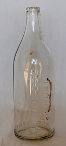
 Bendigo Historical Society Inc.
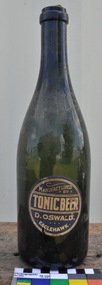
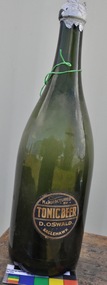
Functional object - BOTTLES COLLECTION: OSWALD EAGLEHAWK
Green Champagne Style Bottle. A broken cork is in the mouth. The bottle is unbroken and has a circular paper label that contains the words ''Tonic Beer manufactured by D. Oswald Eaglehawk.'' The background of he label is dark blue with white lettering. The bottle at the base is 9 cm in diameter and 30 cm high.''Tonic Beer manufactured by D. Oswald Eaglehawk.''food technology, bottling, soft drink bottle -
 Uniting Church Archives - Synod of Victoria
Banner
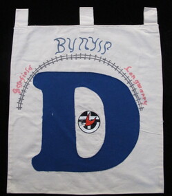
The letters of the completed banner were made by different churches within in the presbytery and spelled a sentence, presumably "BUILD YOUR CHURCH LORD!" Orbost was one of the churches that had the finished banner on display. One of 24 small banners with tabs at the top of each for hanging on a rod. 19 have large blue letters appliqued on them. Twenty two of the banners are roughly square and two are smaller and oblong. Three have no letters and are used as spacers in the four word sentence that the letters make. The banners are decorated with rural and coastal images. BN068.5 "D" with the UCA emblem and "BUNYIP Garfield Longwarry" "D BUNYIP Garfield Longwarry"uniting church adult fellowship -
Hand Tool Preservation Association of Australia Inc
Awl
This item is part of the Thomas Caine Tool Collection, owned by The National Trust of Australia (Victoria) and curated by the Hand Tools Preservation Association of Australia.awl, D ^ D -
 Melbourne Tram Museum
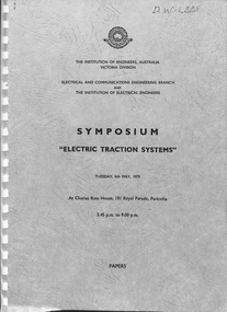
Document - Report, Engineers Australia, "Symposium 'Electric Traction Systems", May. 1975
Report - approx. 55 A4 photocopied sheets - bound with white comb binding, with embossed leather imitation grey card covers, titled "Symposium 'Electric Traction Systems' ", presented by the Institution of Engineers Australia, Vic Div, Tues 6/5/1975. Contains three papers: 1 - "Electricity of Transportation" - R. G. Chapman, SEC 2 - "Electric vehicles for Street Transport:" - F. D. Snell - MMTB 3 - "Electric Railways" - A. Firth - VR Paper 2 looks at the history of the MMTB system, the W class tram, control systems, lack of new trams in the 1960's, ordering of the Z class tram, its specification and manufacture, 980, 1041 and other forms of public transport on roads - trolley buses, gadgetbahns, and lots of possibilities of new systems including battery vehicles.On rear in ink in top right hand corner "D. W. Lees"trams, tramways, reports, mmtb, tramcars, pcc class, z class, melbourne, history, trolley buses, electrical engineering, controllers -
 Melbourne Tram Museum
Photograph - Black & White Photograph/s, Melbourne & Metropolitan Tramways Board (MMTB), Aug. 1973
Black and white photograph of the Transport Minister inspecting prototype tram at Preston Workshops prior to its completion. The trolley pole, numbers and other equipment is yet to be fitted. Outside the tram are Ken Hall and D. H. Eakins. Photo by the Herald and Weekly Times Ltd - has their copyright stamp on the rear. Printed on stippled paper. Not dated, prior to its launch in August 1973.On the rear of the photograph has in pencil. "K. T. Hall - D. H. Eakins - 1041 - Preston - HWT Copyright / Minister of Transport V. Wilcox inside"trams, tramways, 1041, preston workshops, prototype tramcar, minister for transport, tram 1041 -
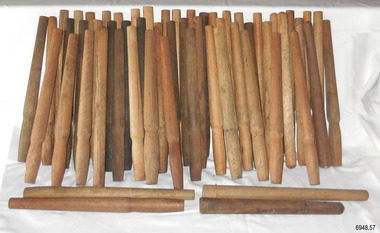 Flagstaff Hill Maritime Museum and Village
Equipment - Belaying Pins, Late 19th Century
The pins in this collection vary in the timber used and the design. They were found in a warehouse beside Crown Casino in Melbourne, located along the Yarra River, close to the sailing ship "Polly Woodside" and not far from the docks of Port Melbourne. Some of the pins have the mark of a 'Broad Arrow' with 'D ↑ D, which signifies that they were the property of the Australian Government's Department of Defence. Belaying pins are essential equipment on a traditional sailing ship of the 19th and early 20th centuries. They are usually made of wood but some are metal. A belaying pin is used to secure the running ropes of the rigging to the ship's rails using holes drilled onto the rails for that purpose. The belaying pins are inserted into holes in the ship’s rail, drilled for that purpose. When the sail has been raised, the ropes are wrapped around the upper and lower sections of the pins in a figure-eight pattern. The shapes of these belaying pins taper from the rounded end of the handle inwards towards the bottom, which allows them to have a firm fit into the holes in the rails. The rigging rope is wound around the pins in such a way that a tug on the pin's handle pulls it out of the hole and quickly frees the rope and the sail.These belaying pins are significant for their association with sailing vessels, particularly vessels of the late 19th and early 20th centuries. They are also significant for their association with the Port of Melbourne where sailing ships docked to and from the Port of Melbourne. Some of the pins have additional significance for being connected with the Australian Government's Department of Defence.Belaying pin, wooden, simple design, wooden shaft with a wider rounded end on top third, tapering to the centre third, which is wider than a lower third. The bottom has a blunt base. Some of the pins have the three sections divided by a line around their circumferences. This collection of fifty-seven pins of varying shapes, colours and timber. Some of the pins are stained with colour, and some have been left natural Stored in a wooden crate. Some have inscriptions.Marks: (Government Defence Department Broad Arrow) "D ↑ D"sailiing equipment, nautical equipment, rigging, yards, flagstaff hill, maritime museum, maritime village, belaying pin, broad arrow, australian government, australian department of defence, sailing ship, sail -
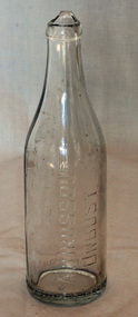
 Bendigo Historical Society Inc.
Functional object - BOTTLES COLLECTION: OSWALD EAGLEHAWK
Large Green Champagne Style Bottle. A Cork With Silver Foil Attached Is In The Mouth. The Bottle Is Unbroken and has A Circular Paper Label That Contains The Words ''Tonic Beer Manufactured By D. Oswald Eaglehawk.'' The Background Of The Label Is Dark Blue With White Lettering. The Bottle At The Base Is 12 cm in Diameter and 38 cm High.''Tonic Beer Manuafactured By D. Oswald Eaglehawk.''food technology, bottling, soft drink bottle -
 The Beechworth Burke Museum
Photograph, W. D. Gibbon, 1905
Taken 1905 by photograph W.D Gibbons the photograph depicts a pathway leading to the administration building of the Beechworth Mental Asylum. There are three well-dressed young men lounging on the grass as another is jumping behind them. This is significant as it demonstrates that the asylum was not a prison and that the mentally ill patients were allowed their freedom. The Beechworth 'Lunatic' Asylum was constructed between 1864 and 1867 to the designs by the Public Works Department (PWD) and was later renamed the Mayday Hills Mental Asylum. The decommissioned asylum was one of the largest psychiatric hospitals in Victoria and consisted of sixty-seven buildings, one thousand two hundred patients and five hundred staff members. At the asylum, active work was considered imperative and workshops were located near the male accommodations and laundries and drying yards near the female accommodation. The administration building itself highlights the architectural and aesthetic significance of the asylum to the State of Victoria. This photograph is historically significant as it demonstrates the architectural and aesthetic significance of the asylum but also the changing approaches to treating mental health. Black and white rectangular photograph printed on matte photographic paper mounted on grey cork Obverse: W.D Gibbon/ Beechworth Reverse: 79.1701beechworth, beechworth lunatic asylum, beechworth mental hospital, mayday hills, mayday hills mental hospital, asylum, administration building, wd gibbon, photograph -
 The Beechworth Burke Museum
Photograph - Photograph - Reproduction, W. D. Gibbon, Early 1900s
This photograph was taken in 1911 at Three Mile Creek, about five kilometers south of Beechworth town. Significant digging took place at this location from late 1855, which led to a flood of workers and stores to follow, though daily earnings were slim compared to the nearby Woolshed site. This remained the case even after workers at Three Mile Creek attempted to protest around Beechworth during an election in November 1855. Three Mile Creek was one of seven significant divisions of the Beechworth Mining District formalised by the Governor-in-Council in 1858, though by the time this photograph was taken, the boundaries of the original seven districts had shifted to create seventeen divisions. The Three Mile Goldfields was a site of rich alluvial gold deposits located about 5km south of Beechworth in Victoria. Today, the location of this gold deposit is called Baarmutha. It was a popular area for gold mining in the 1850s but became largely abandoned by the following decade. In 1865, a man named John Pund (a man second from the left in the back row of this photograph shares this surname) recognized that the area could be potentially rich if a better water supply could be obtained. He secured a 15 year license with three other miners. Within the next five years, these men had constructed 19 km of water race going from Upper Nine Mile Creek to Three Mile Creek. By 1881, these four men had delivered 950,000 gallons to the Three Mile Sluicing area which is depicted in this photograph. Pund would later go into partnership with John Alston Wallace who would become owner of the Star Hotel in Beechworth. The Three Mile sluicing location continued to be operational until 1950. The eleven miners in this photograph are: Back row: Led Guthrie, P. Pund, F. Beel, [Unknown] Miller Front row: Paddy McNamara, J. King, W. Beel, [Unknown] Garland, J. Clarke, J. Ryan, H. Bartsh In the background of the photograph is a huge dirt wall that appears to suffer damage caused by hydraulic sluicing. Hydraulic sluicing is a specialised mining technique that involves directing high pressure water flows at dirt to uncover gold. The technique played a significant role in shaping Beechworth's landscape during the gold rush to create the topography seen today.The search for gold is ingrained into the history of Victoria and therefore, images like this one which portray an open cut sluicing site can reveal important information for society and technology for the date when the photograph was taken. This image is of important historical significance for its ability to convey information about sluicing and the methods used to find gold in the late 1800s and early 1900s. It also shows a location where sluicing was undertook which provides insight into the impact of sluicing on the environment at a time when it was done. Images, like this one, of Australian gold rush history can reveal important information about the social and environmental impact of this period. This image depicts diggers standing in a mining location and therefore, this image has the capacity to reveal or support significant information for researchers studying the fashion and social status of diggers in Australia in approximately 1911. It can also provide information on the landscape of Australia in this period and the impact of mining for gold on both society and the Australian landscape. The Burke Museum is home to a substantial collection of Australian mining photographs which can be used to gain a deeper understanding into life on the gold fields, technology used in mining, the miners themselves and the impact of the gold digging on the environment.Black and white / sepia rectangular reproduced photograph printed on glossy photographic paper mounted on board.beechworth, beechworth museum, mining, mining team, three mile creek, sluicing, hydraulic sluicing, photography, gold sluicing, gold mining, pund mining -
 Orbost & District Historical Society
bottle, after 1929
Dross Drossou established a cordial factory in Orbost in the 1930s. He sold his cordial manufacturing business to Phillips and Stone, a Bairnsdale company, in 1948. Glass bottles were refillable until the 1960s, creating a demand for their collection and onsale back to beverage manufacturers via ‘bottle merchants’. A deposit on the bottles was added to all sales as they left the factory. The returned bottles were washed and the old label removed. The inside was cleaned by pushing the bottle onto a revolving brush. The reusing of the bottles went on until the bottle was broken or the top became chipped.This bottle is an example of a product manufactured by a local industry which no longer exists.A clear glass bottle which has a broken top. The bottle is seamed.Base - AGM F516 Front (written sideways) - A DROSSOU ORBOST Bottom (written around whole bottle) This bottle is the property of A Drossou Orbost M bottle drossou container soft-drink -
 Orbost & District Historical Society
bottle, 1930's
Dross Drossou established a cordial factory in Orbost in the 1930s. He sold his cordial manufacturing business to Phillips and Stone, a Bairnsdale company, in 1948. Glass bottles were refillable until the 1960s, creating a demand for their collection and onsale back to beverage manufacturers via ‘bottle merchants’. A deposit on the bottles was added to all sales as they left the factory. The returned bottles were washed and the old label removed. The inside was cleaned by pushing the bottle onto a revolving brush. The reusing of the bottles went on until the bottle was broken or the top became chipped.This bottle is an example of a product manufactured by a local industry which no longer exists.A clear glass soft drink bottle with a crown seal top. The bottle is seamed.A DROSSOU ORBOST This bottle is the property of A DROSSOU ORBOST Base - AGM F 860 Mbottle container drossou -
 Orbost & District Historical Society
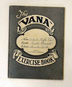
minute books, Social Committee Minute Book, 22.10.1956 - 7.9.1977
The Orbost Rifle Club existed in the early 20th century. (There are records from 1900). It folded in the late 1970's.The Orbost Rifle Club existed in Orbost for over seventy years.A blue Vana exercise book used by the Social Committee of the orbost Rifle Club to record its minutes.On front cover - handwritten - Orbost Rifle Club Social Committee Minute Bookorbost-rifle-club shooting -
 Orbost & District Historical Society
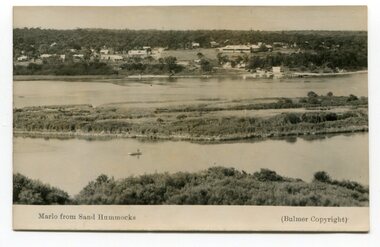
black and white photograph, Howard D. Bulmer, 1936?
Marlo was once a very busy port. Goods needed by the early settlers were carted by sea-going vessels to Marlo. At the Marlo wharf goods were unloaded from the large vessels onto barges and towed by paddle steamers to Orbost. (information - In Times Gone By - Deborah Hall)The Marlo Hotel, perched on the hill overlooking the estuaries and the entrance is a significant building in Marlo. Established in 1886, it has been operating for over 120 yearsA black / white photograph of the Marlo landscape. In the background is the Marlo Hotel. Appears to have been taken from Corringle looking out over ocean and Snowy River. The Marlo Hotel can be seen on the right.Thon front - "Marlo from Sand Hummock"; "Bulmer copyright"marlo-landscape marlo-hotel-township -
 Orbost & District Historical Society
black and white photographs, Howard D. Bulmer, first half 20th century
This bridge was built in the 1920s as a road and rail bridge, and was partly washed away by flood waters in 1934. After the end of the first World War the Victorian Railways considered an extension of the railhead across the river at Orbost, and in 1922 a new timber and steel girder structure, a joint Country Roads Board — Victorian Railways venture, was built and completed at a cost of £41,000 (the steel girders came from the Flinders Street viaduct reconstruction). Subsequently it was decided not to take the railway across the river, and the bridge has only been used by road traffic. This is a pictorial record of an early bridge across the Snowy River at Orbost.A large black / white photograph of the Orbost Snowy River bridge. There is a large copy as well as a postcard copy in sepia.on front - Snowy River Bridge Orbost H.D. Bulmer - photo - Lake Tyers.snowy-river-bridge-orbost