Showing 668 items
matching enlarger
-
 Warrnambool and District Historical Society Inc.
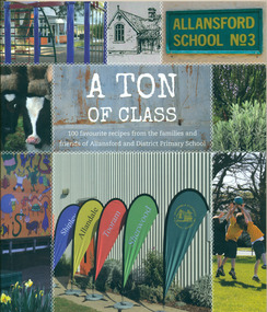
Book, A Ton of Class: 100 favourite recipes from the families and friends of Allansford and District Primary School, 2014
This cookery book was produced in 2014 as a school fundraiser. It was purchased at Allansford Cheese World in January 2015 for $15. Allansford school was established as a National School in 1856 on land reserved for the purpose by John McMahon Allan. It comprised two sandstone classrooms -one for boys and one for girls -with an attached pise teacher's residence. In 1872 when the Victorian Education Department was set up existing schools were listed in alphabetical order and given a number. Allansford State School was No.3. The school was enlarged in the late 1800s and again in the early 1920s. In 1994 following the amalgamation of the Allansford, Allans Forest and Naringal schools a new school was built which adjoined the existing buildings. The old buildings were refurbished as administration and staff facilities. John McMahon Allan settled in the area in 1839 with his brother William Osborne Allan. They were the sons of David Allan, Deputy Commissary General during Macquarie's term of government. The brothers divided the station with William retaining the Allandale portion and John naming his portion Tooram. John McMahon Allan was president of the early district Roads Board. In an attempt to recoup some of the heavy losses due to the disastrous Bateman fire of 1854 John subdivided a portion of Tooram at the Hopkins River crossing known as Allans ford. A school reserve was included in this subdivision. Source: McLeod, Graeme & Barbara. Allansford 1855-2006This book has social and historical interest and significance as it is connected to a local school. It provides a snapshot of food and cooking methods in the early 21st cebturyCookery book with full colour cover featuring 8 photographs and drawings of the Allansford Primary School surrounds and pupil activities on. The images are 'stitched' together with a white zig-zag diamond pattern as if a quilt. The foldout cover has an image of the school's centenary memorial gates and a brief history of the school. Inside the foldout are images of the pupils in each of the school's four team houses. The foldout back cover has full colour images of pupils performing at the school concert. A white strip noting 'our values' is included on the inside back cover foldout. Soft cover, 112 pages.allansford school, a ton of class, allansford primary school, a ton of class recipe book -
 City of Moorabbin Historical Society (Operating the Box Cottage Museum)
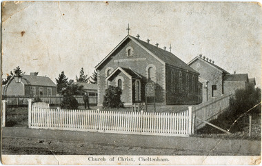
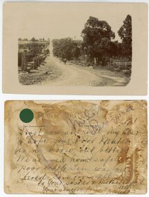
Photograph - Black & White Postcard, Cheltenham Church of Christ 40th Anniversary Invitation, c1900
On his arrival from Scotland c 1857, James Keir commenced a communion service in his home on the Nepean Road. By 1859 the group-which included such other names as Allen, Brough, Cameron, Fairlam, Holdsworth, Le Page, Meeres, Monk, Organ, Penny, Perry, Potts, Sears and King-had built a small chapel near the corner of Wickham and Chesterville Roads. During 1858, a group had also begun meeting in the Charman family home on the corner of Charman and Balcombe Roads. Names associated with this group included Bodley, Charman, Fisher, Hayes, Hilliar, Judd, Moysey and Ruse. In 1860 they built a chapel on the corner of Charman Road and Patty Street. It was enlarged in 1866 and it became the meeting place of the two groups when they came together around 1870. They were able to buy land near the corner of Chesterville and Nepean Roads, and erected a new brick chapel on the site in 1878. This chapel, of course, continues to be an integral part of the life of the Southern Community Church and was one of the three worship venues for the 150th Anniversary celebration in 2007. The Southern Community Church was formed by the amalgamation of the Cheltenham, East Bentleigh and Hampton Street Churches of Christ in 1993, and a comprehensive new facility was designed and built to accommodate the ever-increasing activity of the amalgamated church. It was opened on 30th November 1997. ( Southern Community Church website 2019)c1878 - continuing The Church or Christ Cheltenham was one of the first places of worship established in Cheltenham by the early settlers. The settlers came together, in private homes at first, to support each other spiritually and physically and later built brick Churches for Sunday services and established social and sporting clubsBlack & White photograph as a postcard invitation to the 40th Anniversary of the Church of Christ corner Chesterville Rd and Nepean Highway Cheltenham ( ? 1900)Front Printed ; Church of Christ Cheltenham Back Printed ; POST CARD / One Penny Postage within Commonwealth / The address only to be written here/ One penny Stamp/ Sunday School Anniversary, / OCTOBER 27TH & OCTOBER 30TH / TO WHICH YOU ARE / CORDIALLY INVITED Handwritten in ink ; H.W. got the cramps in the pants. He took some pills then ran over the hills undatedearly settlers, bentleigh, mckinnon, parish of moorabbin, city of moorabbin, county of bourke, moorabbin roads board, shire of moorabbin, were j.b., o'shannassy john, king richard, charman stephen, highett william, ormond francis, maynard dennis, market gardeners, vineyards, orchards, keir james, lepage frank, lepage everest, holloway josiah, bruton henry, keys robert, judd clarence, fairlam percy, meeres william, southern community church, cheltenham, cheltenham church of christ -
 Ballarat Heritage Services
Digital Photograph, St Giles Cathedral, Edinburgh, Scotland, 10/2016
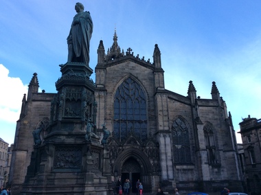
St Giles, also known as the High Kirk of Edinburgh is the principal place of worship for the Church of Scotland. It is very interesting for the mason's marks found on its many stone columns inside the church, and for its connections to the graveyard outside. According to wikipedia, "There is record evidence of a church here, very likely on the present site, in the year 854. In 1120 King Alexander I, rebuilt the church in the Norman style. Of this building characteristic features survived until 1798. During the fourteenth century, Edinburgh was captured and plundered by the English under Edward II. and Edward III., and twice St Giles was laid waste. After restoration, the church was more thoroughly ruined at the Burnt Candlemas in 1387, when Richard II. sacked the city. The western part of the fabric was soon in use again ; but the restoration of the choir and transepts, which were much enlarged, lasted on into the sixteenth century. In 1467 the city endowed St Giles as a collegiate church. It now became usual to speak of the nave, where the stonework was ancient, as the Old Kirk, while the eastern part of the building was called the New Kirk. When the movement for reform drew large crowds to St Giles, separate services began to be regularly held in the Old and New Kirks. Soon this was not enough, and the great church was partitioned off into smaller sections. In 1571 St Giles was seized by Kirkcaldie of Grange, and held by him as a stronghold for Queen Mary. This resulted in serious damage to the structure.Colour photograph of St Giles Cathedral, Edinburgh, Scotlandst giles cathedral, edinburgh, scotland, architecture -
 Ballarat Heritage Services
Digital Photograph, Dorothy Wickham, Interior, St Giles Cathedral, Edinburgh, Scotland, 10/2016
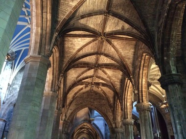
St Giles, also known as the High Kirk of Edinburgh is the principal place of worship for the Church of Scotland. It is very interesting for the mason's marks found on its many stone columns inside the church, and for its connections to the graveyard outside. According to wikipedia, "There is record evidence of a church here, very likely on the present site, in the year 854. In 1120 King Alexander I, rebuilt the church in the Norman style. Of this building characteristic features survived until 1798. During the fourteenth century, Edinburgh was captured and plundered by the English under Edward II. and Edward III., and twice St Giles was laid waste. After restoration, the church was more thoroughly ruined at the Burnt Candlemas in 1387, when Richard II. sacked the city. The western part of the fabric was soon in use again ; but the restoration of the choir and transepts, which were much enlarged, lasted on into the sixteenth century. In 1467 the city endowed St Giles as a collegiate church. It now became usual to speak of the nave, where the stonework was ancient, as the Old Kirk, while the eastern part of the building was called the New Kirk. When the movement for reform drew large crowds to St Giles, separate services began to be regularly held in the Old and New Kirks. Soon this was not enough, and the great church was partitioned off into smaller sections. In 1571 St Giles was seized by Kirkcaldie of Grange, and held by him as a stronghold for Queen Mary. This resulted in serious damage to the structure.Two colour photographs of the interior if St Giles Cathedral, Edinburgh, Scotlandst giles cathedral, architecture, mason's marks, stonemasons, church of scotland -
 Ballarat Heritage Services
Digital Photograph, Stonemason's marks, St Giles Cathedral, Edinburgh, Scotland, 10/2016
St Giles, also known as the High Kirk of Edinburgh is the principal place of worship for the Church of Scotland. It is very interesting for the mason's marks found on its many stone columns inside the church, and for its connections to the graveyard outside. According to wikipedia, "There is record evidence of a church here, very likely on the present site, in the year 854. In 1120 King Alexander I, rebuilt the church in the Norman style. Of this building characteristic features survived until 1798. During the fourteenth century, Edinburgh was captured and plundered by the English under Edward II. and Edward III., and twice St Giles was laid waste. After restoration, the church was more thoroughly ruined at the Burnt Candlemas in 1387, when Richard II. sacked the city. The western part of the fabric was soon in use again ; but the restoration of the choir and transepts, which were much enlarged, lasted on into the sixteenth century. In 1467 the city endowed St Giles as a collegiate church. It now became usual to speak of the nave, where the stonework was ancient, as the Old Kirk, while the eastern part of the building was called the New Kirk. When the movement for reform drew large crowds to St Giles, separate services began to be regularly held in the Old and New Kirks. Soon this was not enough, and the great church was partitioned off into smaller sections. In 1571 St Giles was seized by Kirkcaldie of Grange, and held by him as a stronghold for Queen Mary. This resulted in serious damage to the structure.Colour photographs of tonemason's marks, St Giles Cathedral, Edinburgh, Scotlandmason's marks, st giles cathedral -
 Ballarat Heritage Services
Photograph - Digital Photograph, Stonemason's marks, St Giles Cathedral, Edinburgh, Scotland, 10/2016
St Giles, also known as the High Kirk of Edinburgh is the principal place of worship for the Church of Scotland. It is very interesting for the mason's marks found on its many stone columns inside the church, and for its connections to the graveyard outside. According to wikipedia, "There is record evidence of a church here, very likely on the present site, in the year 854. In 1120 King Alexander I, rebuilt the church in the Norman style. Of this building characteristic features survived until 1798. During the fourteenth century, Edinburgh was captured and plundered by the English under Edward II. and Edward III., and twice St Giles was laid waste. After restoration, the church was more thoroughly ruined at the Burnt Candlemas in 1387, when Richard II. sacked the city. The western part of the fabric was soon in use again ; but the restoration of the choir and transepts, which were much enlarged, lasted on into the sixteenth century. In 1467 the city endowed St Giles as a collegiate church. It now became usual to speak of the nave, where the stonework was ancient, as the Old Kirk, while the eastern part of the building was called the New Kirk. When the movement for reform drew large crowds to St Giles, separate services began to be regularly held in the Old and New Kirks. Soon this was not enough, and the great church was partitioned off into smaller sections. In 1571 St Giles was seized by Kirkcaldie of Grange, and held by him as a stronghold for Queen Mary. This resulted in serious damage to the structure.Three photographs of stonemason's marks, St Giles Cathedral, Edinburgh, Scotlandmason's marks, st giles cathedral -
 Eltham District Historical Society Inc
Photograph, Periwinkle House (1948); Bob and Ada Zull House (1970)
Images 9A and 9B 9A 'Periwinkle House' 1948 For Mr and Mrs J Holmes Built by Sonia Skipper, Horrie Judd, Tony Jackson and others Designed by Alistair Knox 9B Bob and Ada Zull house built 1970 Designed and built by Alistair Knox Floor laid by Ada Zull The Alistair Knox Collection The Alistair Knox Collection is a series of mounted enlarged photos of mud brick houses and related subjects. The collection is understood to have been put together by Alistair Knox although it is the work of several unacknowledged photographers. For some years it was held by the Building Department of the former Eltham Shire Council and was then passed to our Society for safekeeping. Some of the photos have been used in Knox's books and from time to time some of them have been part of various historical displays. As far as we know there has not been a public display of the whole collection which numbers about forty photographs. The collection has been copied on to slides for the purpose of this meeting and to be retained as part of the Society's pictorial collection. Alistair Knox 1912 - 1986 is acknowledged as the founder of Eltham's mud brick building movement. Many of the buildings shown in the collection are of his design and he was also involved with the construction of several of them. Others are the work of his contemporaries and associates such as Peter Glass, Gordon Ford, and John Harcourt. (EDHS Newsletter No. 145 July 2002)Handwritten notes in pencil re details of building, year of construction, owner, designer, builder, etcada zull, alistair knox, alistair knox design, bob and ada zull house, bob zull, horrie judd, houses, j holmes, mud brick construction, periwinkle house, sonia skipper, tony jackson, alistair knox collection -
 Eltham District Historical Society Inc
Photograph, Professor Downing - Dorian Le Gallienne House (1948-1964)
Image 8 Professor Downing - Dorian Le Gallienne House Commenced 1948. Fourth and final wing added 1964 Built by Horrie Judd, Les Puch, Wynn Roberts, Sonia Skipper and others Designed by Alistair Knox The Alistair Knox Collection The Alistair Knox Collection is a series of mounted enlarged photos of mud brick houses and related subjects. The collection is understood to have been put together by Alistair Knox although it is the work of several unacknowledged photographers. For some years it was held by the Building Department of the former Eltham Shire Council and was then passed to our Society for safekeeping. Some of the photos have been used in Knox's books and from time to time some of them have been part of various historical displays. As far as we know there has not been a public display of the whole collection which numbers about forty photographs. The collection has been copied on to slides for the purpose of this meeting and to be retained as part of the Society's pictorial collection. Alistair Knox 1912 - 1986 is acknowledged as the founder of Eltham's mud brick building movement. Many of the buildings shown in the collection are of his design and he was also involved with the construction of several of them. Others are the work of his contemporaries and associates such as Peter Glass, Gordon Ford, and John Harcourt. (EDHS Newsletter No. 145 July 2002)Handwritten notes in pencil re details of building, year of construction, owner, designer, builder, etcalistair knox design, horrie judd, houses, les puch, mud brick construction, professor downing - dorian le gallienne house, sonia skipper, wynn roberts, alistair knox collection -
 Eltham District Historical Society Inc
Photograph, Frank and Morag Jackson House (1960)
Image 25B Frank and Morag Jackson House 1960 Original building designed by Hal Peck Built by Horrie Judd and Hal Peck Extension designed by Macgregor Knox Built by Shane Aumont, commenced 1977 Completed 1978 - Interior view The Alistair Knox Collection The Alistair Knox Collection is a series of mounted enlarged photos of mud brick houses and related subjects. The collection is understood to have been put together by Alistair Knox although it is the work of several unacknowledged photographers. For some years it was held by the Building Department of the former Eltham Shire Council and was then passed to our Society for safekeeping. Some of the photos have been used in Knox's books and from time to time some of them have been part of various historical displays. As far as we know there has not been a public display of the whole collection which numbers about forty photographs. The collection has been copied on to slides for the purpose of this meeting and to be retained as part of the Society's pictorial collection. Alistair Knox 1912 - 1986 is acknowledged as the founder of Eltham's mud brick building movement. Many of the buildings shown in the collection are of his design and he was also involved with the construction of several of them. Others are the work of his contemporaries and associates such as Peter Glass, Gordon Ford, and John Harcourt. (EDHS Newsletter No. 145 July 2002)Handwritten notes in pencil re details of building, year of construction, owner, designer, builder, etcfrank and morag jackson house, frank jackson, hal peck, horrie judd, houses, macgregor knox, morag jackson, mud brick construction, alistair knox collection -
 Eltham District Historical Society Inc
Photograph, Professor Downing - Dorian Le Gallienne House (1948-1964)
Image 8 Professor Downing - Dorian Le Gallienne House Commenced 1948. Fourth and final wing added 1964 Built by Horrie Judd, Les Puch, Wynn Roberts, Sonia Skipper and others Designed by Alistair Knox The Alistair Knox Collection The Alistair Knox Collection is a series of mounted enlarged photos of mud brick houses and related subjects. The collection is understood to have been put together by Alistair Knox although it is the work of several unacknowledged photographers. For some years it was held by the Building Department of the former Eltham Shire Council and was then passed to our Society for safekeeping. Some of the photos have been used in Knox's books and from time to time some of them have been part of various historical displays. As far as we know there has not been a public display of the whole collection which numbers about forty photographs. The collection has been copied on to slides for the purpose of this meeting and to be retained as part of the Society's pictorial collection. Alistair Knox 1912 - 1986 is acknowledged as the founder of Eltham's mud brick building movement. Many of the buildings shown in the collection are of his design and he was also involved with the construction of several of them. Others are the work of his contemporaries and associates such as Peter Glass, Gordon Ford, and John Harcourt. (EDHS Newsletter No. 145 July 2002)Handwritten notes in pencil re details of building, year of construction, owner, designer, builder, etcalistair knox design, horrie judd, houses, les puch, mud brick construction, professor downing - dorian le gallienne house, sonia skipper, wynn roberts, alistair knox collection -
 Eltham District Historical Society Inc
Photograph, Frank and Morag Jackson House (1960)
Image 25A Frank and Morag Jackson House 1960 Original building designed by Hal Peck Built by Horrie Judd and Hal Peck Extension designed by Macgregor Knox Built by Shane Aumont, commenced 1977 Completed 1978 - Exterior view The Alistair Knox Collection The Alistair Knox Collection is a series of mounted enlarged photos of mud brick houses and related subjects. The collection is understood to have been put together by Alistair Knox although it is the work of several unacknowledged photographers. For some years it was held by the Building Department of the former Eltham Shire Council and was then passed to our Society for safekeeping. Some of the photos have been used in Knox's books and from time to time some of them have been part of various historical displays. As far as we know there has not been a public display of the whole collection which numbers about forty photographs. The collection has been copied on to slides for the purpose of this meeting and to be retained as part of the Society's pictorial collection. Alistair Knox 1912 - 1986 is acknowledged as the founder of Eltham's mud brick building movement. Many of the buildings shown in the collection are of his design and he was also involved with the construction of several of them. Others are the work of his contemporaries and associates such as Peter Glass, Gordon Ford, and John Harcourt. (EDHS Newsletter No. 145 July 2002)Handwritten notes in pencil re details of building, year of construction, owner, designer, builder, etcfrank and morag jackson house, frank jackson, hal peck, horrie judd, houses, macgregor knox, morag jackson, mud brick construction, alistair knox collection -
 Bendigo Historical Society Inc.
Mixed media - DONEY COLLECTION: DARKROOM EQUIPMENT
Alan Doney darkroom collection: 40a dartk room equipment collection 40b four film devreloping cannisters, adapts to adjustable film sizes (35mm, 120mm etc) 40c spool winder in two parts, stored in scotch tape tin 40d developer lens holder and fil/negative constraint for enlarging photos 40e darkroom light shade with electricity chord 40f red darkroom safety light for developing film with the darkroom 40g three developing items - two lens caps, thremometer caps/containers, & photo developing tongs 40h leather pouch for protection of flat ground glass panes 40i steel slide cover & bracket 40j two sets of steel film weights to hold/hang developed photograph films 40k rubber tubes and syphons 40l two plastic measuring beakers & two (yellow & blue) plastic spoons for developing process 40m KODAK film flow solution (Keogh's Camera Store $1.02) & KODAK plus-X pan film tin container 40n three darkroom miscellaneous items (includes Uniprint eqipment knob) -
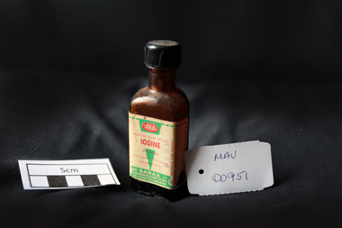 City of Moorabbin Historical Society (Operating the Box Cottage Museum)
Manufactured Glass, brown bottle 'Iodine', 20thC
Iodine is an essential trace element for life, the heaviest element commonly needed by living organisms. In medicine, potassium iodide is usually used to treat acute thyrotoxicosis. Hyperthyroidism, an overactive thyroid, is a condition in which the thyroid gland produces and secretes excessive amounts of the free (not protein bound, and circulating in the blood) thyroid hormones, This is the opposite of hypothyroidism ('sluggish thyroid'), which is their reduced production and secretion. Graves' disease is the most common cause of hyperthyroidism. Iodine's main role in animal biology is as a constituent of the thyroid hormones thyroxine If there is a deficiency of dietary iodine, the thyroid will not be able to make thyroid hormone. The lack of thyroid hormone will lead to decreased negative feedback on the pituitary, leading to increased production of thyroid-stimulating hormone, which causes the thyroid to enlarge (the resulting medical condition is called endemic colloid goitre This has the effect of increasing the thyroid's ability to trap more iodide, compensating for the iodine deficiency and allowing it to produce adequate amounts of thyroid hormone. The thyroid hormones are essential to proper development and differentiation of all cells of the human body. These hormones also regulate protein, fat, and carbohydrate metabolism, affecting how human cells use energetic compounds. They also stimulate vitamin metabolism. Natural sources of iodine include sea life, such as kelp and certain seafood, as well as plants grown on iodine-rich soil. Iodized salt is fortified with iodine. Elemental iodine is used as a disinfectant in various forms. It is a wound cleaner and Iodine also acts as an expectorant of mucous from the common cold and other respiratory ailments. Iodine is a common aid for skin conditions, such as acne, ..A brown glass triangular shaped bottle with a plastic screw top lid that contained IodineFront Label : SANA / TINCTURE WEAK (2 1/2 % ) / IODINE / POISON / ANTISEPTIC COUNTER / IRRITANT ETC. / THE SANAX CO. / 5 BRUNSWICK STREET FITZROY / TEL. J 3208 MELBOURNE. on side : ANTIDOTE FOR IODINE / DIRECTIONS.........pharmacy, medicines, iodine, athritis, glassware, bottles, moorabbin, bentleigh, cheltenham, thyroxin, goitre, iodised salt, gravves' disease -
 Flagstaff Hill Maritime Museum and Village
Functional object - Kerosene Lamp, Perko Inc, 1922 -1930
The company was originally founded by Frederick Perkins a Russian immigrant schooled in Germany as a machinist and tool and die, maker. Frederick came to the United States in the early 1890s and soon became employed as a machinist for E.W. Bliss & Company in Brooklyn, New York. In the early 1900s, he and a partner began operating a business, F. Persky & Company, Lantern Manufacturer, out of the basement of his house. In 1907, Frederick's son Louis joined him in the business, and together they enlarged both the product line and the manufacturing facilities. By 1912, they had seventeen employees and made a wide range of marine lanterns and products. The business continued operating until 1913 when Frederick became president of National Marine Lamp Company, based out of Forestville, Connecticut. Frederick and Louis left that company in 1916 and moved back to Brooklyn, New York, where they started Perkins Marine Lamp Corporation. Five generations later, PERKO is still a privately owned, family-operated corporation. Perkins Marine Corporation was initially known as Perkins Marine Lamp, Inc. The original focus was on the manufacture of hand-formed sheet metal products for the marine market. The first “Perko” catalogue was published in 1916. It included a full range of kerosene and electric lanterns for small and large boats, ventilators, chart cases, signalling devices, mooring buoys, pumps and a variety of spare parts. These products, fabricated from brass, copper and galvanized sheet metal, began a reputation for producing high-quality products. In 1922, the "PERKO" trademark was instituted with each new product utilising the latest, sophisticated metal manufacturing technology.A significant item from an American manufacturer that specialises in making marine products and is still in business today under the same trade name. The subject item is significant as it was made not long after the trade name of PERKO was registered in 1922 and began to be used on the company's various products.Kerosene lamp with circular fuel tank and chrome plated reflector shield. "PERKO" stamped on base.warrnambool, flagstaff-hill, flagstaff-hill-maritime-museum, maritime-museum, shipwreck-coast, flagstaff-hill-maritime-village, kerosene lamp, marine lamp, perko inc, lighting, marine accessories manufacturer -
 St Kilda Historical Society
Photograph, Christ Church St Kilda exterior - images collection #2
Christ Church was constructed in 1854-57 and designed in Decorated Gothic style by Albert Purchase & Charles Swyer. It was enlarged in 1874 and 1881 to the designs of Sydney W Smith. It is one of four main buildings constructed on land granted to the Church of England in 1855 and named Church Square. The other buildings are the bishop's residence, vicarage and parish hall. Heritage Victoria describes it as a 'rare and significant square in the history of town planning in Victoria which demonstrates the importance of the church to the community'. It is built from rarely used undressed random coursed sandstone from Point King Sorrento. It is located at 14 Acland Street, St Kilda. The triangular rose window is said to have been modelled on Lichfield Cathedral and shows outstanding craftsmanship. According to Heritage Victoria, the only other known example in Victoria is at St Georges Presbyterian Church in East St Kilda, designed by the same architect, Albert Purchas. The Church has a varied collection of stained glass, including work by leading stained glass firms and artists in Victoria in the nineteenth and early twentieth century: Ferguson & Urie, William Montgomery and Brooks Robinson. The 'shipwreck window,' north west transept, is an historically significant memorial window dedicated to Miles and William Dalzell Nicholson, the second and third sons of the Hon. William Nicholson, M.L.A, a Lord Mayor of Melbourne and Premier of Victoria in the 1850s. Miles, died in England on 27 April 1874. His younger brother William died in the wreck of the ‘British Admiral’ off King Island on 23 May 1874. The images show the condition of the church at the time they were taken (c 2012). Signs of deterioration can be seen. The bell is not rung any more because of damage to the stonework.There has been some remedial work since and the National Trust of Australia conducted a heritage restoration appeal.churches, acland street, purchase, swyer, st kilda, christ church -
 Eltham District Historical Society Inc
Negative - Photograph, Main Road, Eltham, looking south from Bridge Street, 1906-1907
Looking south along Main Road from the south side of the intersection of Bridge Street with Main Road. Anne Hunniford's Post Office and Burgoyne's store on left. Miss Harriet (Minnie) Williams's Cash Drapery Mart (est. 1902 and enlarged in 1906), also known as Eltham House on the right. Harriet (Minnie) Williams was born London, 1857, the daughter of George John Williams (1812-1895) and Jane Mansfield (1812-1895). In September 1885 she was operating Williams’s Drapery Establishment in premises on Main Road owned by R. Wallis who advertised them to let in September 1885. In 1902 she opened Williams’s Cash Drapery Mart at the southwest corner of Bridge Street and Main Road (opposite the Post Office), owned by W.J. Taylor. In 1906 she bought the premises and one quarter acre of land and expanded the business with a re-opening in April 1906. Harriet was also well-known and esteemed as an active worker in Methodist circles and also Superintendent of the Sunday School. Harriet fell ill in August 1907 and died 15 August. She is buried in Eltham Cemetery with her good friend Ada Ford. Note also the gas street lamp on right. Watson's Hotel on corner of Pitt Street visible in distance. The CBA bank building is hidden behind trees, the chimney and part roof visible. The photo was possibly taken by John Henry Clark of Clark Bros Photographers who operated from 25 Thompson Street, Windsor near Prahan 1894-1914. Evelyn Observer and Bourke East Record (Vic. : 1902 - 1917), Friday 30 March 1906, page 5 ________________________________________ ELTHAM. (FROM OUR OWN CORRESPONDENT.) For over three years Miss Williams has carried on a drapery business in very small and inconvenient premises opposite the Eltham post-office. Recently she bought the building and a quarter-acre of land from Mr. W. J. Taylor. Thus having a free hand, she at once matured plans to enlarge and improve the premises to make them suitable for her growing business. The result being that she consulted Mr Roach, contractor, of Heidelberg, put the matter in his hands, and now he has completed in a very satisfactory manner and up-to-date style extensive improvements. A large addition, of very neat and attractive design, with three large windows, has been built right along the front of the old building, and the counters and inside fittings are very neat and convenient, harmonizing well with the attractive outside appearance. Miss Williams has now got in a large now stock of goods, and is making extensive arrangements for a “reopening week," commencing 2nd April, during which time she will make 10 per cent reduction on all cash purchases in the form of gifts of that value. Miss Williams has gone to considerable expense and liability both, in the enlargement and improvement of the premises and in purchasing additional stock. We therefore trust that the public will stand by her by heartily and en masse patronizing her re-opening effort to show their appreciation of pluck in this advance movement. Google Street View Feb 2017: https://www.google.com.au/maps/@-37.7191341,145.1462046,3a,50.5y,191.91h,88.27t/data=!3m6!1e1!3m4!1sARwwqEQfMSfH9oTWWapPgQ!2e0!7i13312!8i6656 This photo forms part of a collection of photographs gathered by the Shire of Eltham for their centenary project book,"Pioneers and Painters: 100 years of the Shire of Eltham" by Alan Marshall (1971). The collection of over 500 images is held in partnership between Eltham District Historical Society and Yarra Plenty Regional Library (Eltham Library) and is now formally known as the 'The Shire of Eltham Pioneers Photograph Collection.' It is significant in being the first community sourced collection representing the places and people of the Shire's first one hundred years.Digital image (x2) 4 x 5 inch B&W Neg B&W Print 16 x 25 cmsepp, shire of eltham pioneers photograph collection, eltham, main road, anne jane hunniford, burgoyne store, christopher watson, commercial bank of australia, drapery store, eltham house, gas lamp, harriet (minnie) williams, post office, street lamp, watson's hotel, williams's cash drapery mart, clark bros. photo -
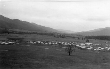 Kiewa Valley Historical Society
Photographs x 2 - 1. Mt Beauty Camp 2. Bogong Camp, Photo 1 - September 1950
Mt Beauty Camp- The new State Electricity Commission construction camp at the head of the Kiewa Valley was for workmen on the second power station in the project expected to be the most modern and best equipped in Australia… In contrast to the early Kiewa days of horses and canvas tents, the new camp, with its modern amenities, compared favourably with any country town. Administration of the Kiewa Scheme was moved from Tawonga to Mount Beauty in 1946. The first house in Mount Beauty, in Hollonds Street, was occupied by the co-op store manager from November 1946. The new Mess Hall at Mt Beauty was opened with much ceremony in early November 1946. The houses up to Nelse street were erected from 1946 onward and then the township was extended beyond Nelse Street in 1950. The workmen's camp was enlarged in 1950 to the extent of providing accommodation for a total of 1,200. Bogong Camp - In 1940 Field Headquarters for the Kiewa Scheme were established at Bogong with office, workshop facilities and accommodation for workmen, staff and some families constructed. (There had been a 'tent camp' on this site in 1939 but was destroyed by bushfires) Construction of accommodation continued until 1947. A total of 40 houses plus a hostel for single staff, post office, police station, medical centre and primary school all with water and sewerage and electricity supply. The staff hostel was known as Kiewa House and is now occupied by the Education Department. Lake Guy was named after Mr. L.T. Guy who was the Resident Engineer in charge of construction work and associated activities on the Kiewa area. He held this position from 1939 to November 1946 when he was transferred to Head Office. Both Bogong Village and Mt Beauty were developed to accommodate workmen on the Kiewa Hydro Electric Scheme but have since become centres for tourism and a range of outdoor activities.1. Black and white photograph of Mount Beauty Camp taken in September 1950 2. Black and white photograph of Bogong Village Camp1. Written on the back in grey lead - Sept 1950. Mt Beauty Camp. HT Cooper own taking 2. Stamped on back of photograph - Copyright. Not for reproduction. Herald Sun feature Service. Melbourne Australiamt beauty camp, bogong camp, secv -
 Cheese World Museum
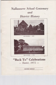
Book, Nullawarre School Centenary and District History, 1975
LeThe Uebergang family came from Silesia to Australia in 1848 and were early settlers in the Allansford area. The sons and other descendants also purchased farms in the area. The Percy Uebergang family lived at Tooram Park, Allansford from 1912 until 1992. Percy and Myrtle Uebergang's children were twins, Ray and Joyce born in 1926 who lived at Tooram Park until their deaths, Ray in 1986 and Joyce in 1992 after which the property was sold. Neither Ray nor Joyce married and following the death of her brother Joyce set up the Ray and Joyce Uebergang Foundation which supports the local community. The collection of items from their property was put into store for a number of years before being given into the care of the Cheese World Museum. The family often re-used, recycled and repaired items and examples can be seen in the museum. This item is part of the collection of items given into the care of the Cheese World Museum. Nullawarre State School No.1652 opened in 1875 on a site donated by George Henry. The weatherboard school was 27ft by 18ft. Margaret Mathieson was the first of the 17 pupils registered. The first head teacher was Charles A Bruford. The first building was replaced with a new building by 1975 when the celebrations took place. A brief history of Nullawarre township and some of its early residents is also included. Early families include Mathieson, Burleigh, LeCouteur, Wallace and Hesketh. A photograph of the Nirranda and District WWI Honor Roll details those from the Nullawarre area who served. Today the school has been enlarged and is now Nullawarre and District Primary School.This booklet is significant as it provides a history of Nullawarre school and an overview of the Nullawarre district and some of its early residents. A cream coloured booklet with sepia coloured text and photographs of the school.Nullawarre School Centenary/and/District History/OLD SCHOOL-1975/NEW SCHOOL-1975/"BackTo" Celebrations/-Easter 1975-/SOUVENIR BOOKLETallansford, nullawarre, uebergang, schools, henry, bruford, mathieson, burleigh, lecouteur, wallace, hesketh, nullawarre state school -
 Eltham District Historical Society Inc
Document, Certificate as to Trustees of Wesleyan Church land, Lot 20 Henry Street, Little Eltham North, 7 Oct 1901
The Trustees for Lot 20 Henry Street were declared by the Wesleyan Methodist Church on 7 October 1901 to be Revd. Barnabas Shaw Walker, Minister of the Pentridge Circuit, Joseph Cooper, Gardener of Keelbundora, Samuel Jeffrey, Farmer of Jika Jika, Francis Thomas, Farmer of Doncaster and sometime of Keelbundora, John Brown, State School Teacher, William John Taylor, Gardener, Robert David Taylor, Gardener and Isaac Hill, Dealer, all of Eltham. Originally purchased in 1856 from Thomas Roberts, Yeoman of Little Eltham, for £10 for use by the Wesleyan Chapel, represented by indentured Trustees, Rev. Barnabas Shaw Walker, Minister of the Pentridge Circuit, Francis Thomas, Farmer of Keelbundora, William Harriman, Blacksmith of Nillumbik, Nicholas Rodda, Farmer of Nillumbik, Aaron Grimshaw, Farmer of Greensborough, Joseph Cooper, Gardener of Keelbundora, Peter Dredge, Scholmaster of Jika Jika and Samuel Jeffrey, Farmer of Jika Jika. Lot 20 of Subdivision of Portion 13, Section 4 of the Parish of Nillumbik in the County of Evelyn was located on the southern side of Henry street in Little Eltham North, where the current Our Lady Help of Christians Catholic Church is situated. It became the location of the Eltham Rechabite Hall. In 1893 a new hall was built and further enlarged in 1919. At the commencement of 1922, the property was purchased from the Independent Order of Rechabites with publicly subscribed funds and a new hall built at a cost of £750 and improved road access constructed to reduce the grade, running from Dudley Street to Henry Street. This hall was eventually replaced with the new Shire Offices and Hall built on the corner of Arthur Street and Main Road, which was opened in 1941. Traces the earliest history of the Eltham Public Hall in Henry Street and the various names, occupations and abodes of the Trustees associated with the propertyeltham public hall, eltham rechabite hall, eltham wesleyan chapel, francis thomas, henry street, james abel marsland, james massland, john brown, joseph cooper, little eltham north, rev barnabas shaw walker, robert david taylor, samuel jeffrey, trustee, william john taylor, little eltham, isaac hill -
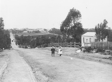 Ringwood and District Historical Society
Photograph, Addison home 1902 Ringwood in background
Black and white photograph of scene showing unmade road with two children, a boy and a girl standing outside a small wooden building. Lady is sitting by the side of road. Road dips down to a bridge then rises again towards distant settlement in background. (3 copies)Typed below enlarged photo, "Addison home, 1902 - Opposite present St. Paul's, Warrandyte Road". Written on backing sheet, "Andersons Creek Rd. 1903. Mrs. Addison (Annie Kennedy) and family - Annie, born 1897 and William. Their house at right was on a 5 acre block. Ringwood in background". Backing sheet of another copy reads, "Andersons Creek Road 1902 (Warrandyte Rd. looking south). Mrs. Addison (Annie Kennedy) and family. Annie (Jnr), born 1897 and Samuel John James William, born 1894. Their home, at right, was on a 5 acre block. Ringwood in background - burned down by pet magpie. T. Grant's land ploughed - now Eastland. Adelaide St. seen on right of it. Mullum Creek Bridge at foot of hill". Typed below this photograph, "Warrandyte Rd. Ringwood looking south from near Mullum Rd. Ringwood in background. Maroondah Highway at top of hill with Mullum Creek bridge seen in dip - 1902". -
 Ringwood and District Historical Society
Photograph, Maroondah Highway Central, Ringwood. Warrandyte Rd looking North from Main Street, Ringwood. 1908
Black and white photograph reproduced from post card. Scene of road looking towards Loughnan Hill, Andrew Kennedy's orchard. Horse and cart in centre of photo, orchard to left of picture. (3 enlarged copies, 2 postcards, a clipping and 1 9x18.5 reproduction) Postcards with correspondence from N Blood, 2 original of the postcards with messages. First reads: "Trust you are well my dear and hope your poor Mater is no worse but better. We arrived home safely..poor little Tim was very tired. Love from all to your sister and mother..self. Your sincere friend, N. Blood" Second Reads: "Miss Hill. Cowes P.O.. 4/3/09 Dear Olive, come at once; I am on my last legs! Very pleased to hear that you have been enjoying yourself as well. Your mother had been very ill and Elvie has lost a stone weight; and ??? looks down in the dumps. Topsy killed canary this morning so I took Topsy for a walk! Had a bush fire up at home on 22 and 23rd Feb. No time to scribble more. Yours to a cinder. Bert." This postcard writing is overstamped J.B.McAlpin, Estate and Financial Agent. District Government Valuer Ringwood. It has a 1d Victorian Stamp affixed. Typed below photograph, "Warrandyte Rd. from Maroondah Hwy. looking north. Mullum Creek bridge in dip - 1908". -
 Eltham District Historical Society Inc
Document, Conveyance, Lot 20 Henry Street, Eltham, Hope of Eltham Tent No. 195 I.O.R. to W.J. Capewell and others, 31 Dec 1926
Indenture between Jack Alfred Harrison, Accountant, Edward Samuel McColl, Council Employee, both of Eltham and William Wilson, Coachbuilder of Research, the Trustees of a certain Friendly Society known as The Hope of Eltham Tent No. 195 Victorian District I.O.R of the one part and William James Capewell, Butcher, Ernest James Andrew, News Agent and George Birchall, Hatter all of Eltham of the other part, Trustees for The Eltham Hall, for the purchase of Lot 20 Henry Street for £750. Witnessed by Hubert James Carter J.P for Jack Alfred Harrison, A.H.C. Price J.P. for Edward Samuel McColl and J. Webster J.P. for William Wilson. Originally purchased in 1856 from Thomas Roberts, Yeoman of Little Eltham, for £10 for use by the Wesleyan Chapel, represented by indentured Trustees, Rev. Barnabas Shaw Walker, Minister of the Pentridge Circuit, Francis Thomas, Farmer of Keelbundora, William Harriman, Blacksmith of Nillumbik, Nicholas Rodda, Farmer of Nillumbik, Aaron Grimshaw, Farmer of Greensborough, Joseph Cooper, Gardener of Keelbundora, Peter Dredge, Scholmaster of Jika Jika and Samuel Jeffrey, Farmer of Jika Jika. Lot 20 of Subdivision of Portion 13, Section 4 of the Parish of Nillumbik in the County of Evelyn was located on the southern side of Henry street in Little Eltham North, where the current Our Lady Help of Christians Catholic Church is situated. It became the location of the Eltham Rechabite Hall. In 1893 a new hall was built and further enlarged in 1919. At the commencement of 1922, the property was purchased from the Independent Order of Rechabites with publicly subscribed funds and a new hall built at a cost of £750 and improved road access constructed to reduce the grade, running from Dudley Street to Henry Street. This hall was eventually replaced with the new Shire Offices and Hall built on the corner of Arthur Street and Main Road, which was opened in 1941. Traces the earliest history of the Eltham Public Hall in Henry Street and the various names, occupations and abodes of the Trustees associated with the property -
 Surrey Hills Historical Society Collection
Photograph, Davis, Johns and Street families in Surrey Hills, c1919
Identification provided by the donor, Mrs Ruth Edgar (nee Johns), as follows: Back row - L to R: Miss Hilda Davis (later Mrs F A McLaughlin), of 16 Valonia Avenue, aged 103 in 1995 and the only one in the photo then alive; E Murray Johns, eldest son of Rev and Mrs Wesley Johns of Mont Albert; he married and built a home in Scheele Street and lived there until he was promoted to Head Office of the Bank of NSW; brother of the donor; Miss Ethel Street from Wodonga, daughter of Mrs Theresa Street in the front row; an unidentified friend; Mr Walter E Davis, Manager of the Telegraph Branch of the G.P.O. and a keen member of the Surrey Hills Bowling Club, owner of 40 Windsor Crescent and an active member of the Surrey Hills Methodist Church. Front row - L to R: Mrs W E Davis, sister of E J Nuttall of Surrey Hills, one of the co-designers of the Australian flag; W Lyndon Davis, son of Mr & Mrs W E Davis, who built and lived in Lightfoot Street; Mrs Theresa Street from Wodonga, sister of Mr W E Davis & Mrs Wesley Johns; Mr Walter Street, son of Mrs T Street, newly returned from WW1 with his young English bride, Helen. Walter Edwin Davis - born 1858, married Bertha Amy Nuttall / Davis (1864-1941) in 1889. Walter Lyndon Davis (1895-1970) Ruth Lilian Johns (1911-2004) daughter of Wesley Johns & Elizabeth Davis. The photo was enlarged & reprinted from a 75 year-old photo 2 inches by 3 inches by a local firm "Think Negative" in Mont Albert. A black and white photograph of 5 women and 5 men assembled in a group in the garden of a building. One man is in uniform, the other men are wearing suits. The ladies are wearing long skirts.valonia avenue, windsor crescent, lightfoot street, world war, 1914-1918, helen (mrs), mr e murray johns, rev wesley johns, scheele street, miss ethel street, mrs w e davis, miss bertha amy nuttall, walter lyndon davis, walter edwin davis, miss hilda davis, mrs frederick arthur mclaughlin, mrs theresa street, miss theresa emily davis, miss elizabeth davis, mrs elizabeth johns, walter frederick street, mrs helen swtreet, miss helen hewlett, ernest murray johns -
 Mt Dandenong & District Historical Society Inc.
Photograph, Jeeves Coach on CRB Road at Foot of Farringdon Road Kalorama, 1920, 1920
Scene looking down Farringdon Road showing Jeeves horse drawn coach going along the CRB road (Mt Dandenong Tourist Road) in 1920. Detailed inscription on the back handwritten by John Lundy-Clarke in 1974.Jeeves Coach on CRB road at foot of Farringdon Road Kalorama (Mt Dandenong North) 1920. Road was formed most of the length from Montrose by contractors Bladin and Dick employing Robert Logan the younger, in 1919 and lay unmetalled till metalled by the contractors in 1922. Mountain ash trees in foreground were on Thomas Hand’s original 23 acre holding. Those beyond coach were on Isaac Jeeves original 160 acre holding Selection Crown Allotment 925(B). This was the area forming part of the inheritance lost by John William Richardson because of the expense of his wife’s illness. Hand enlarged his 23 acres to 305 in 1874. William and his family grew large crops of raspberries on his area, part of which is in the foreground. It had been cleared by his father’s employees before 1877. The section below the Main Road was cultivated by Fred hand, son of William and grandson of Thomas in the twenties before he moved to Redcliffes where he is today (1974). Comment by John Lundy-Clarke 10.5.1974 coach service, jeeves, crb road, farringdon road, kalorama, mt dandenong north, mt dandenong tourist road, john lundy-clarke, coach -
 Eltham District Historical Society Inc
Slide, Maroondah Aqueduct, Research, Victoria, 22 Mar. 1981
An inspection tour of the Maroondah Aqueduct was undertaken by the Shire of Eltham Historical Society on Sunday, March 22nd, 1981, commening where the aqueduct crosses Main Rd., Research, just below Eltham College. The Maroondah Aqueduct was part of Melbourne’s water supply system. It carried water over the 66 km from the Maroondah Reservoir on the Watts River at Healesville to the Preston Reservoir. Of this length, 41 km were open channel, 10 km, tunnel through hills and 15 km in 14 inverted siphons across stream valleys. The route of the aqueduct is north of Tarrawarra and Yarra Glen, along the Yarra escarpment south of Christmas Hills and crossing Watsons Creek into the present Shire of Eltham near Henley Rd. The eastern part of the route lies entirely within the former boundaries of the shire. The aqueduct passes south of Kangaroo Ground to Research and crosses the Diamond Creek by siphon at Allendale Rd., Eltham North. It then extends to Reservoir via St. Helena, Greensborough North and Bundoora. Water first flowed through the aqueduct in February 1891 when it was fed by a diversion weir on the Watts River. Records of the building of the aqueduct indicate that it was a significant construction achievement. The present Maroondah Reservoir was completed in 1927 and the aqueduct was enlarged at that time to take increased flows. About 1971 the section of the aqueduct through and north of Research was replaced by a large pipe and that section of the channel is now unused. The channel has remained largely intact (unlike sections at Greensborough and Bundoora where long lengths of the disused aqueduct have been demolished or filled in). The M.M.B.W. relinquished control of the disused aqueduct reserve which is crown land and the Shire of Eltham took control of this section of the reserve as a linear park. The Maroondah Aqueduct is considered to be an important historic structure, not just to the local area but to the metropolitan area generally. It is considered important to preserve substantially intact long lengths of the disused aqueduct, together with its bridges and other associated structures. 35 mm colour positive transparency (1 of 5) Mount - Agfachrome Agfa CS System black 8 dotsactivities, heritage excursion, maroondah aqueduct, research (vic.), shire of eltham historical society -
 Eltham District Historical Society Inc
Photograph, 35 Ingrams Road, Research, Eltham Heritage Tour, 24 May 1992, 24/05/1992
ELTHAM HERITAGE TOUR The Society excursion on 24th May 1992 was arranged by David Bick, leader of the team carrying out the Shire's heritage study. David selected a number of sites or buildings identified in the study, some of them lesser known components of the Shire's heritage. The tour commenced at the Eltham Shire Office at 10.00 am. Travel was by private car and mini-bus with stops at about twelve locations for commentary by David.It included a short walk in Hurstbridge and lunch at Kinglake. Highlights of the tour included: - 10 am Leave from Shire Offices - 3 Important Trees - A Physical Link to Eltham's First Settlers - Toorak Mansion Gates - A Surviving Farm House - An Intact Circa 1900 Main Street - First Settlers - Gold Miners, and Timber-getters - An Early Hotel - A Pioneering Homestead - Changing Eltham Shire - 20th Century - 4 pm Afternoon Tea and Finish Tour Extract from ELTHAM CULTURAL HERITAGE TOUR (Newsletter No. 85, July 1992, by Bettina Woodburn) "On a right-angle turning of the Eltham Road is Wellers Pub, a Cobb & Co. coaching stop on the way to distant gold-fields and places north of the Yarra River. The Hotel dates from the 1870's. Daily distances for a bullock team was eight miles, horses could do double that distance. We turned into Cassells Road and on the corner of Ingrams Road we admired an elaborate Edwardian villa, 1900 style. The Aqueduct conveying Melbourne's water supply was a communication line and a technological advance in 1891. It has been enlarged and re-faced and no longer used here but piped underground. Proclaimed a linear park it has reverted to crown land, controlled by local Council. Maroondah Dam was constructed in. 1920 to replace the original weir and at that time: the Aqueduct - as established into the landscape - with bridges and tunnels and pine trees were used to stop rubbish polluting the water."Record of the Society's history and activities and highlighting various aspects of the Heritage Study undertaken by David Bick used to create the future heritage overlay for the Shire of Eltham and later Nillumbik Shire.Roll of 35mm colour negative film, 4 stripsKodak Gold 100 5095shire of eltham historical society, activities, heritage tour, ingrams road, research (vic.)