Showing 1947 items matching "floods"
-
 Kew Historical Society Inc
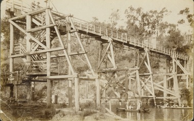
Postcard - Zig-Zag Bridge
Sepia postcard of the Zig-Zag Bridge at Kew. The bridge was constructed in the 1870s to link the Yarra Bend Asylum and Kew Asylum. Initially it transported bluestone from the west side of the Yarra to the east during the construction of the Kew Asylum.Reverse: "Old Tramway Bridge / erected early 1850s / Zig Zag Bridge below mental grounds / washed away in flood / linked the mental asylums / donated by G.L. Beard"bridges - yarra river -- kew (vic.), zig-zag bridge -
 Linton and District Historical Society Inc
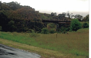
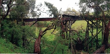
Photograph, Dilapidated bridge over Springdallah Creek, Happy Valley/Piggoreet, 2010
This bridge was built in the 1880s. By the 1980s it was in a dilapidated condition and was replaced. The old bridge was further damaged by storms and flooding in November 2010 and January 2011. (The newer bridge was completely washed away when the Springdallah Creek flooded in January 2011.) In 2025, little remains of the old bridge.Colour photograph of a trestle bridge spanning Springdallah Creek, Linton-Piggoreet Road.trestle bridges, old springdallah bridge -
 Linton and District Historical Society Inc
Photograph, Dilapidated bridge over Springdallah Creek, Happy Valley/Piggoreet, 2010
This bridge was built in the 1880s. By the 1980s it was in a dilapidated condition and was replaced. The old bridge was further damaged by storms and flooding in November 2010 and January 2011. (The newer bridge was completely washed away when the Springdallah Creek flooded in January 2011.) In 2025, little remains of the old bridge.Two colour photographs of a trestle bridge spanning Springdallah Creek, Linton-Piggoreet Road. The two photographs have been sticky-taped together to form one panoramic image.trestle bridges, old springdallah bridge -
 Eltham District Historical Society Inc
Negative - Photograph, Carl Walter 1831-1907, Coffer dam in the Yarra River at Anderson's Creek, 1864
... floods ...1864 photograph of the Coffer Dam in the River Yarra situated (approximately) opposite Whipstick Gully. Remains of bridge built in 1860(?) wrecked by 1863 flood in background. Reproduced page 29 of ‘Pioneers & Painters’ Gold was first discovered in this area at Andersons Creek (Warrandyte) in June 1851 by Louis Michel. Discoveries north of the Yarra did not occur until about 1854. Although it took some months for a true rush to develop it was not long before alluvial workings were being carried on in most of the Shire of Eltham. The last area in which gold was discovered was Kinglake. As the gold became harder to find, deep mining took over from alluvial diggings in the gullies. Perhaps the most extensive of the deep workings was the Diamond Creek Mine just outside the boundary of the Shire. This form of mining was continued into the 1930s. There are believed to be some mines in the area still capable of producing gold but present prices make working these uneconomical. Some gold is still found by weekend prospectors. Photo: Carl Walter 1831-1907 – inscribed on tent “C. Walter Photo” The State Library of Victoria holds over 150 photos by Carl Walter, most of which are portraits of Aboriginal natives including William Barak.This photo forms part of a collection of photographs gathered by the Shire of Eltham for their centenary project book,"Pioneers and Painters: 100 years of the Shire of Eltham" by Alan Marshall (1971). The collection of over 500 images is held in partnership between Eltham District Historical Society and Yarra Plenty Regional Library (Eltham Library) and is now formally known as 'The Shire of Eltham Pioneers Photograph Collection.' It is significant in being the first community sourced collection representing the places and people of the Shire's first one hundred years.Digital image 4 x 5 inch B&W Neg (2) Print 20 x 25 cmshire of eltham pioneers photograph collection, anderson's creek, coffer dam, floods, gold mining, other areas, pioneers and painters, warrandyte, warrandyte bridge, yarra river -
 Malmsbury Historical Society
Photograph (Item), "Peter Bruni In Boat, Malmsbury Flood October 2000", Malmsbury oct 2000
People - "Bruni, Peter" Buildings - Cricket Ground Associated with - Herald Sun Flood -
 Port Fairy Historical Society Museum and Archives
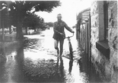
Photograph
evidence of the 1946 floods in Bank Street outside the Keats house in Port Fairy Black and white photograph of Male walking a bicycle on footpathflood, river, bank street, 1946, keats -
 Charlton Golden Grains Museum Inc
Photograph, Cameron, Ian, c.1973
1973 Flood in High Street Charlton. Bill Landos outside his cafe. Black and white photograph with white boarder.1975 in blue biro written on bottomflood, cba bank, kenny's drapery, bill's cafe, charlton, business -
 Eltham District Historical Society Inc
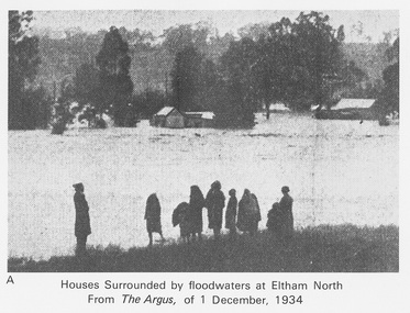
Work on paper (Sub-Item) - Photograph, Houses surrounded by floodwaters at Eltham North
"The house (centre) at North Eltham in which Mr. and Mrs. William Frizell, an elderly couple, were marooned by flood waters. When this photograph was taken late yesterday afternoon the couple were still inside the house, and through a ventilator they had stuck a red flag which they waved from time to time. The house on the left belongs to Mr. Leads, who also was marooned." - The Argus 1 December 1934. John William Frizell, painter and his wife Sarah Jane are registered at Glen Park, Eltham in the 1924 Electorial Roll This was most probably the Diamond Creek in flood. In 1934 extensive flooding of the Yarra River and Diamond Creek sets new records for flood plain level (via Chronology of Eltham, EDHS) flood, frizell, leads, argus, glen park, eltham north, flooding, marooned, diamond creek -
 Orbost & District Historical Society
black and white photograph, February 1971
This photograph is an aerial view of the township of Orbost taken by the Bairnsdale Advertiser newspaper. It was taken from the northern end of the town. The 1971 flood was the the worst flood on record. At Jarrahmond it was at least 11 metres and up to one and a half kilometres wide on the flats causing enormous damage to the flood plain. Records say that "The brown floodwater stain in Bass Strait could be seen from passing airliners." Considerable damage was done to railway infrastructure, roads and farms. More information from the APRIL, 2008 newsletter by John Phillips. (see orbosthistory.com.au)This is a pictorial record of a significant event in the history of Orbost,A black / white aerial photograph of a township with floodwaters in the background.on back - "Note main current through the lagoon 1971."orbost-floods-1971 bairnsdale-advertiser orbost-township -
 Orbost & District Historical Society
black and white photograph, January 1934
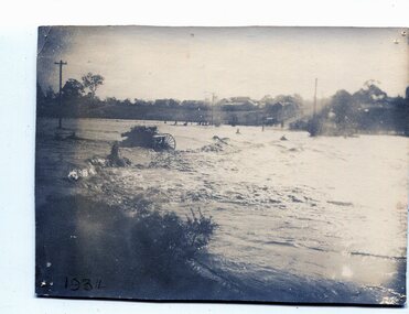
From The Argus (Melbourne) on January 10 1934 "Damage estimated at £500,000 has been caused by the floods in the Orbost district. No loss of life occurred, largely owing to the heroic efforts of rescue parties. Many families spent Monday night on the roofs of houses or in trees, surrounded by deep, rushing flood waters." This 1934 flood was devastating, destroying a section of the 1922 Orbost bridge - the centre span was washed away -. wrecking fences, bridges and roads, dumping silt and debris on the rich river flats and drowning cattle. This is a pictorial record of the 1934 flood, a significant event in the history of Orbost.A black / white photograph of floodwaters. In the middle of the water can be see debris including a large spoked wheel. In the background are houses and fences.on back - "near Hilyer's garage at foot of hill Main Street Caravan Park on right" on front at bottom left - "1934"orbost-flood-1934 flood-orbost -
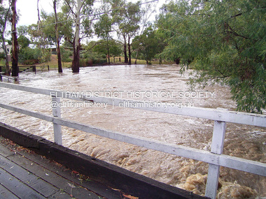
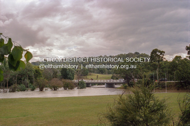
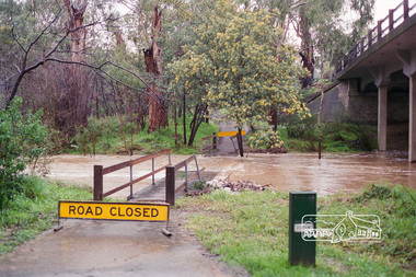
 Eltham District Historical Society Inc
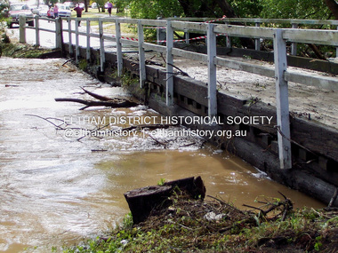
Photograph - Digital Photograph, Jim Connor, Brougham Street Bridge, Eltham in flood, 13 Nov 2004
... floods ...brougham street bridge, diamond creek (creek), floods, floodwater -
 Eltham District Historical Society Inc
Photograph - Digital Photograph, Jim Connor, Brougham Street Bridge, Eltham in flood, 3 Feb 2005
... floods ...brougham street bridge, diamond creek (creek), floods, floodwater -
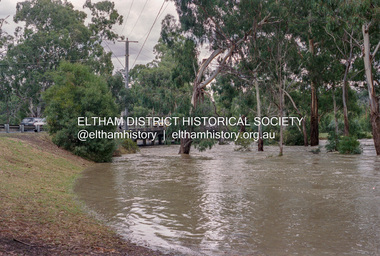
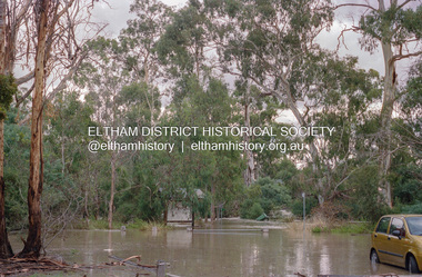
 Eltham District Historical Society Inc
Photograph, Diamond Creek floodwaters near the Main Road Bridge, Eltham, Jan-Feb 2005, 2005
... floods ...Roll of 35mm colour negative film, 7 stripsKodak GC400-8diamond creek, eltham, floods, main road bridge -
 Eltham District Historical Society Inc
Photograph, Diamond Creek floodwaters near the Main Road Bridge, Eltham, Jan-Feb 2005, 2005
... floods ...Roll of 35mm colour negative film, 7 stripsKodak GC400-8diamond creek, eltham, floods, main road bridge -
 Eltham District Historical Society Inc
Photograph, Diamond Creek floodwaters near the Main Road Bridge, Eltham, Jan-Feb 2005, 2005
... floods ...Roll of 35mm colour negative film, 7 stripsKodak GC400-8diamond creek, eltham, floods, main road bridge -
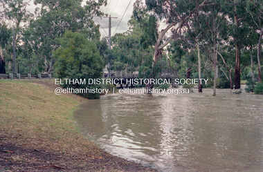
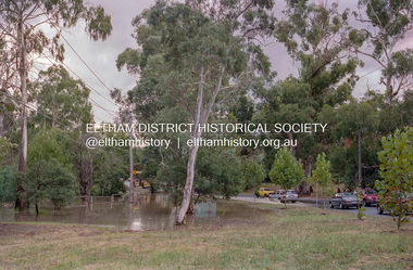
 Eltham District Historical Society Inc
Photograph, Diamond Creek floodwaters in Wingrove Park, Eltham, Jan-Feb 2005, 2005
... floods ...Roll of 35mm colour negative film, 7 stripsKodak GC400-8diamond creek, eltham, floods, wingrove park -
 Eltham District Historical Society Inc
Photograph, Diamond Creek floodwaters in Wingrove Park, Eltham, Jan-Feb 2005, 2005
... floods ...Roll of 35mm colour negative film, 7 stripsKodak GC400-8diamond creek, eltham, floods, wingrove park -
 Eltham District Historical Society Inc
Negative - Photograph, Diamond Creek floodwaters near the Bridge Street Bridge, Eltham, Jan-Feb 2005, February 2005
... floods ...Roll of 35mm colour negative film, 7 stripsKodak GC400-8diamond creek, eltham, floods, bridge street -
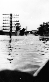
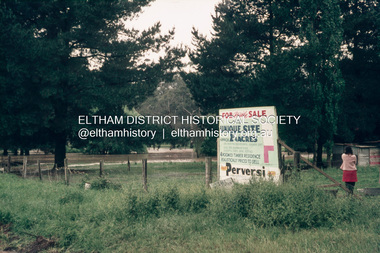 Eltham District Historical Society Inc
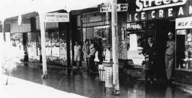
Slide, Floodwater, Ely Street, east of Falkiner Street, Eltham, November 1971, 1971
... floods ...35 mm colour positive transparency Mount - Agfacolor Service (Blue)eltham, ely street, floods, real estate advertisement -
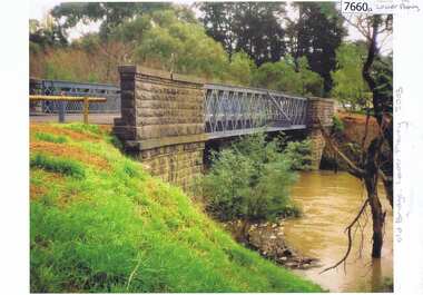 Greensborough Historical Society
Photograph - Photograph (Copy), Anne Paul, Old bridge, Lower Plenty 2003, 2003_12
... floods ...Two views of the old bridge over the Plenty River in Lower Plenty.2 colour photographs printed on paper, handwritten captionslower plenty, plenty river, floods, edward willis drive lower plenty -
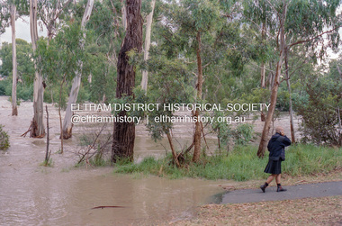
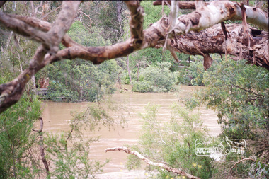 Eltham District Historical Society Inc
Photograph, Peter Pidgeon, Yarra River flooded, confluence with Diamond Creek viewed from lookout at Lenister Farm, Eltham, 2004
... floods ...Digital file onlyfloods, diamond creek, yarra river, lenister farm -
 Eltham District Historical Society Inc
Photograph, Peter Pidgeon, Yarra River flooded, confluence with Diamond Creek viewed from lookout at Lenister Farm, Eltham, 2004
... floods ...Digital file onlyfloods, diamond creek, yarra river, lenister farm -
 Eltham District Historical Society Inc
Photograph, Warrandyte. Main Road looking north toward Hotel, c.1928
... floods ...Source: Mrs. E.M. Jackson, Pigeon Bank, Kangaroo GroundThis photo forms part of a collection of photographs gathered by the Shire of Eltham for their centenary project book,"Pioneers and Painters: 100 years of the Shire of Eltham" by Alan Marshall (1971). The collection of over 500 images is held in partnership between Eltham District Historical Society and Yarra Plenty Regional Library (Eltham Library) and is now formally known as the 'The Shire of Eltham Pioneers Photograph Collection.' It is significant in being the first community sourced collection representing the places and people of the Shire's first one hundred years.Digital imagesepp, shire of eltham pioneers photograph collection, warrandyte, floods -
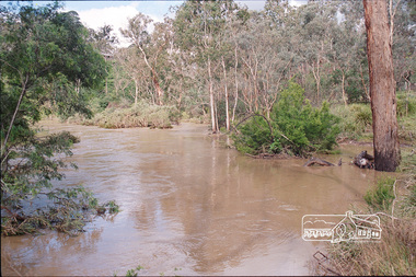
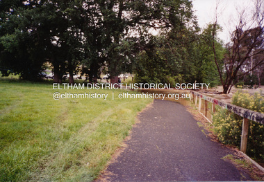
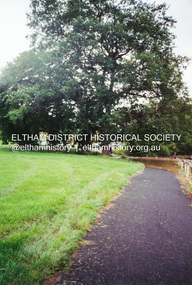
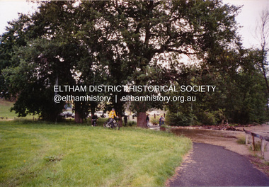 Eltham District Historical Society Inc
Photograph, Diamond Creek in flood, Eltham, 13 Nov 2004, 13/11/04
... floods ...Three colour photographs of the floodwater from Diamond Creek crossing the path below the Eltham Community Centre.eltham, diamond creek, floods, eltham community centre -
 Eltham District Historical Society Inc
Photograph, Diamond Creek in flood, Eltham, 13 Nov 2004, 13/11/04
... floods ...Three colour photographs of the floodwater from Diamond Creek crossing the path below the Eltham Community Centre.eltham, diamond creek, floods, eltham community centre -
 Eltham District Historical Society Inc
Photograph, Diamond Creek in flood, Eltham, 13 Nov 2004, 13/11/04
... floods ...Three colour photographs of the floodwater from Diamond Creek crossing the path below the Eltham Community Centre.eltham, diamond creek, floods, eltham community centre -
 Eltham District Historical Society Inc
Negative - Photograph, Harry Gilham, Diamond Creek flooding over the Main Road footbridge, Eltham, c.Aug. 1996
... floods ...Roll of 35mm colour negative film, 5 of 6 stripsKodak Gold 100-5diamond creek, footbridge, main road, floods -
 Eltham District Historical Society Inc
Negative - Photograph, Harry Gilham, Diamond Creek flooding over the Main Road footbridge, Eltham, c.Aug. 1996
... floods ...Roll of 35mm colour negative film, 5 of 6 stripsKodak Gold 100-5diamond creek, footbridge, main road, floods -
 Stawell Historical Society Inc
Photograph, Paxton Street Bridge on Concongella Creek in Great Western in flood 1988-- 2 Photos
Paxton Street Bridge Concongella Creek - Great Western. Flooding 2/9/1988stawell -
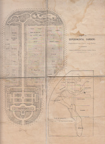 University of Melbourne, Burnley Campus Archives
Plan, Alfred Lynch, Plan of the Experimental Gardens of the Horticultural Society of Victoria. Survey Paddock. Richmond, 1861
Subsequently the area was not fully developed in this manner following flooding in 1863. Some remnants remain.Plan on paper with cloth backing. Inscription, "Designed by Alfred Lynch. Landscape Gardener, Prahran. Printed by De Guchy & Leigh." An inset plan shows position of Experimental Gardens related to the City of Melbourne and Bay. Plan shows layout and plantings of the designated area - fruit, vegetables: the conservatory, nursery, exhibition buildings. This plan was owned by E.E. Pescott. Inscription on cover, "Burnley. E.E.P.." "Ed. E. Pescott." Subsequently the area was not developed in this manner. See inscription on copy made for Centenary Exhibition B92.633. Other copies given to College by N. Lothian (graduated 1934). Jim Sanders, a friend of his, gave them to Dr. G. Moore in 1991. A larger copy, inscribed on reverse, '1861', 'Early proposals for Horticultural Gardens for Horticultural Society of Victoria (now Royal). The lithograph was included as an insert in the Farmers Journal and Gardeners Chronicle 21 June, 1862. It is only in one of the copies held by the State Library of Victoria. 1 large and 1 small photographs of plan. Several photocopies of the plan.Inscription, "Designed by Alfred Lynch. Landscape Gardener, Prahran. Printed by De Gruchy & Leigh." / Inscription on cover, "Burnley. E.E.P.." "Ed. E. Pescott."alfred lynch, experimental gardens, conservatory, nursery, e.e. pescott, n. lothian, jim sanders, dr. g. moore, horticultural socoety of victoria