Showing 800 items matching "garden design"
-
 Kew Historical Society Inc
Photograph - 2 Young Street, Kew, Paramount Photos, 1920s
Subdivision plans are historically important documents used as evidence of the growth of suburbs in Australia. They frequently provide information about when the land was sold on which a built structure was subsequently constructed as well as evidence relating to surveyors and real estate and financial agents. The numerous subdivision plans in the Kew Historical Society's collection represent working documents, ranging from the initial sketches made in planning a subdivision to printed plans on which auctioneers or agents listed the prices for which individual lots were sold. In a number of cases, the reverse of a subdivision plan in the collection includes a photograph of a house that was also for sale by the agent. These photographs provide significant heritage information relating house design and decoration, fencing and household gardens.A prepossessing, large home constructed in the Arts and Crafts style. Located on the banks of the Yarra at 2 Young Street, Kew overlooking the factories of Richmond, the design of the house takes account of the gradient with the addition of a level below the front entrance. The elegant roof includes a number of projecting gables and dormers. The gables are typically half-timbered and rendered. In addition to the asymmetrically placed portico, there are at least two open verandas, supported by timber pillars and with roofs that reflect the overall pitch of the roof of the housereal estate photographs, 2 young street - kew -
 Kew Historical Society Inc
Photograph - 29 Uvadale Grove, Kew, 1920
The numerous subdivision plans in the Kew Historical Society's collection represent working documents, ranging from the initial sketches made in planning a subdivision to printed plans on which auctioneers or agents listed the prices for which individual lots were sold. In a number of cases, the reverse of a subdivision plan in the collection includes a photograph of a house that was also for sale by the agent. Subdivision plans are historically important documents used as evidence of the growth of suburbs in Australia. They frequently provide information about when the land was sold on which a built structure was subsequently constructed as well as evidence relating to surveyors and real estate and financial agents. These photographs provide significant heritage information relating house design and decoration, fencing and household gardens.When 29 Uvadale Grove, Kew was offered for sale it was described as: ‘Kew. Fine locality, 3 minutes Cotham Road. Splendidly built 6 roomed Brick Villa. Rooms 17 x 14, 16 x 13, &c. Beautifully fitted throughout. Land 70 x 134 to ROW.’ The price was advertised as being £1,400. The house exhibits key features of Federation architecture such as the gabled roof with a facing of half-timber and stucco. The veranda has a curved corrugated iron roof supported by timber pillars and fretwork. The slate roof with terra cotta ridging and finials marks a transition to the more common use of Marseilles tiles in Federation architecture.subdivisions - kew (vic.), 29 uvadale grove - kew (vic.) -
 Kew Historical Society Inc
Photograph - 'Mount Eri', 9 Highbury Grove, 1919
Subdivision plans are historically important documents used as evidence of the growth of suburbs in Australia. They frequently provide information about when the land was sold on which a built structure was subsequently constructed as well as evidence relating to surveyors and real estate and financial agents. The numerous subdivision plans in the Kew Historical Society's collection represent working documents, ranging from the initial sketches made in planning a subdivision to printed plans on which auctioneers or agents listed the prices for which individual lots were sold. In a number of cases, the reverse of a subdivision plan in the collection includes a photograph of a house that was also for sale by the agent. These photographs provide significant heritage information relating house design and decoration, fencing and household gardens.A photograph of Mount Eri, 9 Highbury Grove, an 11-room house for sale near the junction of Cotham and Glenferrie Roads. The substantial red brick, slate-roofed house and its location are not identified in the photograph, although the extent of the house is noted. It was described then as ‘well situated’ and close to 3 trams. Mathers, a financial agent in Cotham Road, placed advertisements about the sale of the property in The Argus in May and June 1919. The advertisement additionally refers to a billiard room and asserts that the house has every modern convenience. An annotation on the plan indicates that the house, with tennis court, was sold for £1960. Following extensive research, the house has now been conclusively identified, albeit extended and rendered. The house was originally built in the 19th century as a school and for much of the 20th century was used as a venue for receptions. -
 Kew Historical Society Inc
Photograph - Victorian Villa, High Street, c.1922
Subdivision plans are historically important documents used as evidence of the growth of suburbs in Australia. They frequently provide information about when the land was sold on which a built structure was subsequently constructed as well as evidence relating to surveyors and real estate and financial agents. The numerous subdivision plans in the Kew Historical Society's collection represent working documents, ranging from the initial sketches made in planning a subdivision to printed plans on which auctioneers or agents listed the prices for which individual lots were sold. In a number of cases, the reverse of a subdivision plan in the collection includes a photograph of a house that was also for sale by the agent. These photographs provide significant heritage information relating house design and decoration, fencing and household gardens.An old inscription on this photograph identifies it as ‘an elegant timber villa in High Street. It occupied part of Lot 91, bought by Edward Glyn in the land sale of 16th October 1851, and run as a flower farm’. The subdivision called the ‘Flower Farm Estate’ in East Kew occurred in 1922. [The subdivision plan is on the reverse of this photo.] The Estate included 61 lots on either side of Boorool Road between High Street and Harp Road. In the MMBW Detail Plan 2017 of 1926, a number of these new villas had already been built. Matching houses with MMBW maps can always be a challenge, however if this house was near the corner of Boorool Road and High Street, it seems to fit the profile of a house called ‘Maxton’ (demolished).Photographer's name on photograph, lower right, and stamp on mount lower right: "A. Aberline, Glenferrie".houses - maxton - high street - kew (vic.), violet farm estate, subdivisions - kew (vic.) -
 Kew Historical Society Inc
Photograph - 8 roomed DF Brick Villa, Kew, J E Barnes, c.1920
Subdivision plans are historically important documents used as evidence of the growth of suburbs in Australia. They frequently provide information about when the land was sold on which a built structure was subsequently constructed as well as evidence relating to surveyors and real estate and financial agents. The numerous subdivision plans in the Kew Historical Society's collection represent working documents, ranging from the initial sketches made in planning a subdivision to printed plans on which auctioneers or agents listed the prices for which individual lots were sold. In a number of cases, the reverse of a subdivision plan in the collection includes a photograph of a house that was also for sale by the agent. These photographs provide significant heritage information relating house design and decoration, fencing and household gardens. The photograph is of additional aesthetic significance as it was photographed by J. E. Barnes. Josiah Earl Barnes is a nationally significant photographer. He was also the most important photographer to have worked in Kew. He was active as a photographer in the district from c.1906 until his death in 1921. Best known as 'the Embarkation Photographer' (see the Australian War Memorial collection), J. Earl Barnes was also the official photographer employed by the Borough (and later Town, then City) of Kew. He clearly also completed commercial jobs for local businesses, as is the case in this photograph of a house for a local real estate and financial agent.A photograph, mounted on board of a double fronted Federation-era brick villa in Kew, photographed for a local real estate agent and financier by J. E. Barnes of Kew. On the reverse of the photograph is a subdivision plan for the Normanby Estate, East Kew - 2016.0039.1. As can be seen from the image, there is a large tear on the surface of the photograph.The brown card on which the photograph is mounted includes the following handwritten description, which may aid the identification of the house: "Kew, 3 minutes from tram, 8 roomed DF Brick Villa, tile roof including two attics, sleepout, bathroom, heater, E Light, Entrance Hall, double doors, leadlights, laundry, garden, lawns, land 75 x 170, 1975 pounds". Also photographers inscription on mount, lower left: J. E. Barnes / Photo / Phone 1966 Haw. KEW.j. e. barnes, josiah earl barnes, j. earl banes - photographer, architecture - federation style, houses - kew, real estate photographs -
 Kew Historical Society Inc
Photograph - W.B. Villa, Kew, c.1919
The photograph offers significant information relating to late Victorian / Federation colour schemes and fencing.The block fronted villa has a corrugated iron roof and a flat projecting verandah, ornamented with a trellis design of timber. The front window features a timber shade, mounted on brackets. The treatment of the block-fronted panels shows that there is an attempt to highlight imitation quoining through use of a darker colour. The windows and door are also in this darker shade. The front fence and gate are made of wooden pickets. It is unlikely that the photograph was taken at the time of the villa's construction given the size of the shrub/tree in the front garden.Subdivision plans are historically important documents used as evidence of the growth of suburbs in Australia. They frequently provide information about when the land was sold on which a built structure was subsequently constructed as well as evidence relating to surveyors and real estate and financial agents. The numerous subdivision plans in the Kew Historical Society's collection represent working documents, ranging from the initial sketches made in planning a subdivision to printed plans on which auctioneers or agents listed the prices for which individual lots were sold. In a number of cases, the reverse of a subdivision plan in the collection includes a photograph of a house that was also for sale by the agent. These photographs provide significant heritage information relating house design and decoration, fencing and household gardens.A real estate photograph, mounted on brown card, showing a double fronted weatherboard villa, located in Kew, Victoria. On the reverse of the photograph is a subdivision plan for the Altyre Estate.Stamped on mount: Top - "KEW. Close tram. Fine View. / W.B. Villa Containing 8 Rooms. / Up-to-date Conveniences. EL Etc." Below - "Land 40 x 165. 615 pounds. Sold"houses - kew, real estate photographs -
 Kew Historical Society Inc
Photograph - Double-fronted Edwardian Villa, c.1918
The Kew Historical Society's map collection includes a substantial number of real estate subdivision plans, mainly of Kew but also of surrounding suburbs in Melbourne. Most of the subdivision plans date from the 1920s and 1930s when the districts old homes and local farmland were being split up to accommodate residential growth in the postwar period. These early plans were assembled by a local firm, Jas R Mather & McMillan, which had an office in Cotham Road. Many of the plans, and sometimes photos, were annotated by the agents.Subdivision plans are historically important documents used as evidence for the growth of suburbs in Australia. They frequently provide information about when the land was sold as well as evidence relating to surveyors and real estate and financial agents. The numerous subdivision plans in the Kew Historical Society's collection represent working documents, ranging from the initial sketches made in planning a subdivision to printed plans on which auctioneers or agents listed the prices for which individual lots were sold. In a number of cases, the reverse of a subdivision plan in the collection includes a photograph of a house that was also for sale by the agent. These photographs provide significant heritage information relating house design and decoration, fencing and household gardens.The photograph may also be aesthetically significant depending on the importance of the photographic atelier.On the reverse of a subdivision plan of the Palmyra Estate (Kew) is a photograph of a double-fronted Edwardian villa. The weatherboard and stucco house with high brick chimneys provides a clear indication of the style of curtains and gardens in houses of the period. Holland blinds with lace inserts are used in the left front window. They are combined with long lace curtains. The garden, with its curved pathway is bordered with garden beds that include marguerite daisies and roses. Reflecting a new interest in the Australian landscape, tree ferns and ground ferns are planted closer to the house.houses - kew, architecture - edwardian, real estate photographs -
 Kew Historical Society Inc
Plan - Subdivision Plan, J R Mathers & McMillan, Normanby Estate, c.1913
The Kew Historical Society's map collection includes a substantial number of real estate subdivision plans, mainly of Kew but also of surrounding suburbs in Melbourne. Most of the subdivision plans date from the 1920s and 1930s when the districts old homes and local farmland were being split up to accommodate residential growth in the postwar period. These early plans were assembled by a local firm, Jas R Mather & McMillan, which had an office in Cotham Road. Many of the plans, and sometimes photos, were annotated by the agents.Subdivision plans are historically important documents used as evidence for the growth of suburbs in Australia. They frequently provide information about when the land was sold as well as evidence relating to surveyors and real estate and financial agents. The numerous subdivision plans in the Kew Historical Society's collection represent working documents, ranging from the initial sketches made in planning a subdivision to printed plans on which auctioneers or agents listed the prices for which individual lots were sold. In a number of cases, the reverse of a subdivision plan in the collection includes a photograph of a house that was also for sale by the agent. These photographs provide significant heritage information relating house design and decoration, fencing and household gardens.The photograph may also be aesthetically significant depending on the importance of the photographic atelier.The Normanby Estate, which was adjacent to Normanby Road, Kew East, included thirty-one lots for sale. Streets on the subdivision plan include Adeney Avenue, Park Hill Road, Normanby Road, Weir Street and Wharton Street. Cotham Road and its tramway are shown nearby. The plan is interesting as it shows Wharton Street, named after the architect and town planner George Wharton, who was the first chairman of the Municipality of Kew. The street was to later be renamed Cecil Street. Also shown are proposed ‘Municipal Gardens’ where Parkhill Drive is now located."D" in top left corner. Stamped auctioneers contact details: "Jas. R. Mathers & Son & McMillan / Auctioneer & Land Salesmen, / 271 Collins Street / Melbourne" and Jas. R. Mathers / Estate & Financial Agent / Cotham Road / Kew".weir street - kew, wharton street - kew, normanby road - kew, cotham road - kew, municipal gardens - kew, park hill parkhill road - kew, braemar - kew, subdivision plans - kew -
 Kew Historical Society Inc
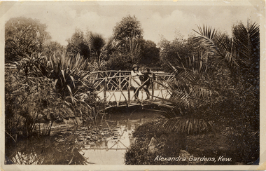
Postcard, Alexandra Gardens, Kew, 1910-1920
Named after Queen Alexandra, these beautiful gardens opened in 1908 and are designed in the formal style typical of the early 1900s.Early postcard showing architectural features and original plantings.The Alexandra Gardens, Cotham Road Kew. The postcard depicts a pedestrian bridge within the Gardens. The bridge, on which are standing two children, has rustic sides. On the evidence of this postcard, planting within the Gardens included a range of exotic specimens including a variegated aloe and water lilies. Native vegetation can be seen in the distance.alexandra gardens - kew (vic), postcards -- kew (vic.) -
 Kew Historical Society Inc
Postcard, Alexandra Gardens, Kew, 1908-1918
Named after Queen Alexandra, these beautiful gardens opened in 1908 and are designed in the formal style typical of the early 1900s.Early postcard showing original architectural features and plantings.The Alexandra Gardens, Cotham Road Kew. The postcard depicts a pedestrian bridge within the Gardens. The bridge, on which are standing two children, has rustic sides. On the evidence of this postcard, planting within the Gardens included a range of exotic specimens including a variegated aloe and water lilies. Native vegetation can be seen in the distance.alexandra gardens - kew (vic), postcards -- kew (vic.) -
 Kew Historical Society Inc
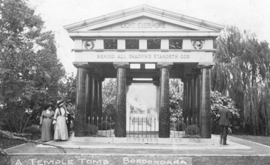
Postcard, A Temple Tomb in Kew Cemetery, 1914-1932
... Harold Desbrowe-Annear designed the Springthorpe Memorial... Harold Desbrowe-Annear designed the Springthorpe Memorial, while ...Harold Desbrowe-Annear designed the Springthorpe Memorial, while Bertram Mackennal sculpted the statuary on the sarcophagus. William Guilfoyle is belived to have advised on the design of the garden.A temple tomb in the form of a Greek temple with a triangular pediment. Dark pillars on a flat, paved base support the plinth of the memorial. The memorial is situated on lawn, surrounded by trees and shrubs. Between the pillars, a glass enclosure can be clearly seen. The enclosure was removed at a later date.springthorpe memorial, boroondara general cemetery, kew cemetery, postcards -- kew (vic.), funerary monumnets -
 Kew Historical Society Inc
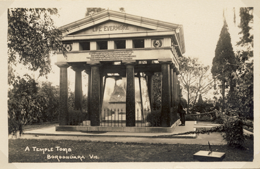
Postcard, A Temple Tomb Boroondara Vic, 1914-1920
... date. Harold Desbrowe-Annear designed the Springthorpe Memorial... Guilfoyle is belived to have advised on the design of the garden ...A temple tomb in the form of a Greek temple with a triangular pediment. Dark pillars on a flat, paved base support the plinth of the memorial. The memorial is situated on lawn, surrounded by trees and shrubs. Between the pillars, a glass enclosure can be clearly seen. The enclosure was removed at a later date. Harold Desbrowe-Annear designed the Springthorpe Memorial, while Bertram Mackennal sculpted the statuary on the sarcophagus. William Guilfoyle is belived to have advised on the design of the garden.Photographic postcard of the east facing side of the Springthorpe Memorial in the Boroondara General (Kew) Cemetery. The photograph of the tomb record the original glass case surrounding the central group of statuary as well as a man at right contemplating the tomb. An interesting feature is the vine in the foreground covering the chain. There is also a small sundial at lower right.springthope memorial, boroondara (kew) general cemetery - victoria - australia, funerary monuments, postcards -- cemeteries -
 Kew Historical Society Inc
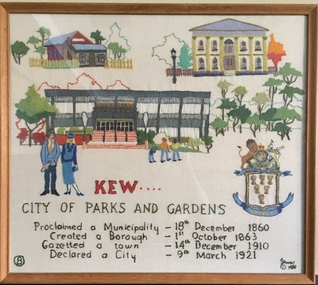
Textile - Bicentennial tapestry, 8. Kew. City of Parks and Gardens, 1988
This is one of eight embroidered panels, completed during the 1988 Australian Bi-Centennial, and carried out under the auspices of City of Kew Council and the Kew Historical Society. Nearly 600 residents, including many children, participated in their production by adding a few or more stitches. A book records their names and the panels upon which they worked. Artist: Joy Stewart / Co-ordinator: Dorothy Benyei.8. Kew. City of Parks and Gardens. A framed embroidery created by adults and children of the City of Kew as a Bicentennial project, based on a design by the artist Joy Stewart. Five of the six completed embroideries created in the project are/were displayed in the Kew Library. [The five embroidered panels have now been temporarily removed for conservation reasons].Inscription: "KEW: City of Parks and Gardens / Proclaimed a Municipality December 1860 / Created a Borough 1st October 1863 / Gazetted a Town 14th December 1910 / Declared a City 9th March 1921." Embroidered signature of the artist: "(c) JStewart, 1988"bicentennial project (kew), joy stewart, charles grimes expedition, australian bicentennial -
 Kew Historical Society Inc
Textile - Bicentennial tapestry, 3. East Kew State School, 1988
This is one of eight embroidered panels, completed during the 1988 Australian Bi-Centennial, and carried out under the auspices of City of Kew Council and the Kew Historical Society. Nearly 600 residents, including many children, participated in their production by adding a few or more stitches. A book records their names and the panels upon which they worked. Artist: Joy Stewart / Co-ordinator: Dorothy Benyei.3. East Kew State School. A framed embroidery created by adults and children of the City of Kew as a Bicentennial project, based on a design by the artist Joy Stewart. Five of the six completed embroideries created in the project are/were displayed in the Kew Library. [The five embroidered panels have now been temporarily removed for conservation reasons].Inscription: "EAST KEW STATE SCHOOL / Typical country school attended by children from surrounding farms and market gardens." Embroidered signature of the artist: "(c) JStewart, 1988"bicentennial project (kew), joy stewart, charles grimes expedition, australian bicentennial -
 Kew Historical Society Inc
Photograph, J F C Farquhar, The Post Office, 1891
At the beginning of the 1890s, the Kew businessman and Town Councillor, Henry Kellett, commissioned J.F.C. Farquhar to photograph scenes of Kew. These scenes included panoramas as well as pastoral scenes. The resulting set of twelve photographs was assembled in an album, Kew Where We Live, from which customers could select images for purchase.The preamble to the album describes that the photographs used the ‘argentic bromide’ process, now more commonly known as the gelatine silver process. This form of dry plate photography allowed for the negatives to be kept for weeks before processing, hence its value in landscape photography. The resulting images were considered to be finely grained and everlasting. Evidence of the success of Henry Kellett’s venture can be seen today, in that some of the photographs are held in national collections.It is believed that the Kew Historical Society’s copy of the Kellett album is unique and that the photographs in the book were the first copies taken from the original plates. It is the first and most important series of images produced about Kew. The individual images have proved essential in identifying buildings and places of heritage value in the district.A panoramic photograph of the junction of High Street and Cotham Road. The photographer centres the point-of-view on the Kew Post Office and adjacent Court House. These were designed in the Queen Anne style by the Public Works Department's architect J Harvey and completed in 1888. The complex is important because it demonstrates a departure from the contemporaneously favoured High Victorian Classical to the Queen Anne style in the design of civic buildings. The earlier Jubilee Fountain in front of the Post Office was erected by the Kew Borough Council to commemorate the Golden Jubilee of Queen Victoria in 1887. It was created to a design of the architects Reed, Henderson and Smart. The fountain was later relocated to the Alexandra Gardens to make way for the Kew War Memorial. The tram tracks in High Street were used by the horse tram, which ran from the Victoria Street Bridge to the Boroondara General Cemetery. The tram was replaced by an electrified service in 1915.The Post Officekew post office, kew illustrated, kew where we live, photographic books, henry kellett -
 Kew Historical Society Inc
Photograph, J F C Farquhar, A View in Studley Park Road, 1891
At the beginning of the 1890s, the Kew businessman and Town Councillor, Henry Kellett, commissioned J.F.C. Farquhar to photograph scenes of Kew. These scenes included panoramas as well as pastoral scenes. The resulting set of twelve photographs was assembled in an album, Kew Where We Live, from which customers could select images for purchase.The preamble to the album describes that the photographs used the ‘argentic bromide’ process, now more commonly known as the gelatine silver process. This form of dry plate photography allowed for the negatives to be kept for weeks before processing, hence its value in landscape photography. The resulting images were considered to be finely grained and everlasting. Evidence of the success of Henry Kellett’s venture can be seen today, in that some of the photographs are held in national collections.It is believed that the Kew Historical Society’s copy of the Kellett album is unique and that the photographs in the book were the first copies taken from the original plates. It is the first and most important series of images produced about Kew. The individual images have proved essential in identifying buildings and places of heritage value in the district.This is the earliest known photograph of the exterior of Byram (later Tara Hall). It shows the original red brick fence, its asymmetrical gate and gateposts, with a large terra cotta gargoyle surmounting the higher of the two. The architect, Edward Kilburn designed Byram in the Arts & Crafts style for the industrialist George Ramsden. Construction began in 1888 and was reputed to have lasted three years. The mansion had frontages to Studley Park Road and Stevenson Street, including gardens laid out with great taste, including pleasure grounds, tennis lawn, fruit and flower garden, and paddock. The size of many of the trees in the garden indicate that many survived from the garden of Clifton Villa, the previous single-storeyed house built on the site by the Stevenson brothers. Byram had views to Melbourne and Port Phillip Bay. The house was demolished in 1960, despite opposition from the National Trust (Victoria), and its gardens subdivided into residential allotments.A View in Studley Park Roadkew illustrated, kew where we live, photographic books, henry kellett, byram, tara hall, goathlands -
 Kew Historical Society Inc
Postcard, A Temple Tomb , Boroondara, 1900-1910
... date. Harold Desbrowe-Annear designed the Springthorpe Memorial... Guilfoyle is belived to have advised on the design of the garden ...A temple tomb in the form of a Greek temple with a triangular pediment. Dark pillars on a flat, paved base support the plinth of the memorial. The memorial is situated on lawn, surrounded by trees and shrubs. Between the pillars, a glass enclosure can be clearly seen. The enclosure was removed at a later date. Harold Desbrowe-Annear designed the Springthorpe Memorial, while Bertram Mackennal sculpted the statuary on the sarcophagus. William Guilfoyle is belived to have advised on the design of the garden.An early black and white postcard of the Springthorpe Memorial in the Boroondara General Cemetery. There are numerous often undated postcards showing the memorial. This example features two women standing at left and a man at right. Based on the women's costumes, the postcard can be dated to 1900-1910.A Temple Tomb / Boroondara springthorpe memorial, boroondara general (kew) cemetery, postcards -- cemeteries, postcards -- kew (vic.) -
 Kew Historical Society Inc
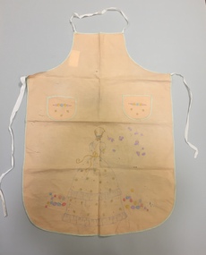
Clothing - Hand-Embroidered Cotton Pinafore, 1950s
The Fashion & Design collection of Kew Historical Society includes examples of women’s, men’s, children’s and infants' clothing from the 18th, 19th and 20th centuries. While the collection includes some examples of international fashion, most items were handmade or purchased in Melbourne. Apricot-coloured cotton apron, hand embroidered with a design of a woman in a garden. The apron has two symmetrically placed embroidered pockets. The apron may be a Semco pattern.clothing - women's, aprons, fashion design, fashion -- 1950s -
 Kew Historical Society Inc
Journal, Kewriosity : June 1992
Mountain bikes for Kew Police / p1. Kew Junction Commercial Area Urban Design Options Precincts 1&2 / p1. Responsible dog ownership / p1. Waste Management Strategy / Cr Daryl Oldaker, Malcolm Hutchinson p2&3. Home care for Kew residents / p3. Diary Dates for June/July / p4. Community tree planting day / p5. Friends of Kew Library / p5. Sharps disposal containers/ p5. In Brief [Recycling garden pots; Recycling kerbside collection; Outdated phone books recycled; Kew Pre-school Association; Australian Orthodoxy; Adult literacy classes; Football news; Women at midlife] / p6.Passive smoking - How much does it affect you? / p7. Don't Litter [and fines] / p7. Pictures of Kew [winner of decorated hat exhibition]; Flying start holiday camp [at Carey]; Kew High school teacher and student; James W Waters Award] / p8.Kewriosity was a local newsletter combining Kew Council and community news. It was published between November 1983 and June 1994, replacing an earlier Kewriosity [broad] Sheet (1979-84). In producing Kewriosity, Council aimed to provide a range of interesting and informative articles covering its deliberations and decision making, together with items of general interest and importance to the Kew community and information not generally available through daily media outlets.non-fictionMountain bikes for Kew Police / p1. Kew Junction Commercial Area Urban Design Options Precincts 1&2 / p1. Responsible dog ownership / p1. Waste Management Strategy / Cr Daryl Oldaker, Malcolm Hutchinson p2&3. Home care for Kew residents / p3. Diary Dates for June/July / p4. Community tree planting day / p5. Friends of Kew Library / p5. Sharps disposal containers/ p5. In Brief [Recycling garden pots; Recycling kerbside collection; Outdated phone books recycled; Kew Pre-school Association; Australian Orthodoxy; Adult literacy classes; Football news; Women at midlife] / p6.Passive smoking - How much does it affect you? / p7. Don't Litter [and fines] / p7. Pictures of Kew [winner of decorated hat exhibition]; Flying start holiday camp [at Carey]; Kew High school teacher and student; James W Waters Award] / p8. publications -- city of kew (vic.), kewriosity, council newsletters, community newsletters -
Kew Historical Society Inc
Journal, Kewriosity : February 1992
Kew Youth Arts Festival: 1992 [Two weeks of culture & entertainment; Photo competition; writing competition] / p1. Chief Executive's Comment [Proposal for old library area below Municipal Offices to be leased to Australia Post as a distribution centre] / Malcolm Hutchinson p2. Mayor's Comment [Kew's Old Post Office] / Cr Daryl Oldaker p3. Kew Citizen of the Year Award Australia Day 1992 [Graeme Lindsay] / p3. Diary Dates for February/March [1992] / p4. Community Directory / p4. Free sausage sizzle breakfast at the Kew Recreation Centre / p5. Spare Time? [volunteering at Kew Cottages] / p5. Kew Garden Club [photo Yvonne Knight, Alex McKay] / p5. Urban design guidelines for Lower Yarra River / p6. Nursing Mothers' Association / p6. Kew Community House - 6 Derby Street / p6. New parking signs / p7. Adult literacy [Swinburne College of TAFE Access Education Department] / p7. National Trust's Guide to Renovating Inter-War houses /p8. Row boat for disabled [Rotary Club of Kew] / p8.Kewriosity was a local newsletter combining Kew Council and community news. It was published between November 1983 and June 1994, replacing an earlier Kewriosity [broad] Sheet (1979-84). In producing Kewriosity, Council aimed to provide a range of interesting and informative articles covering its deliberations and decision making, together with items of general interest and importance to the Kew community and information not generally available through daily media outlets.non-fictionKew Youth Arts Festival: 1992 [Two weeks of culture & entertainment; Photo competition; writing competition] / p1. Chief Executive's Comment [Proposal for old library area below Municipal Offices to be leased to Australia Post as a distribution centre] / Malcolm Hutchinson p2. Mayor's Comment [Kew's Old Post Office] / Cr Daryl Oldaker p3. Kew Citizen of the Year Award Australia Day 1992 [Graeme Lindsay] / p3. Diary Dates for February/March [1992] / p4. Community Directory / p4. Free sausage sizzle breakfast at the Kew Recreation Centre / p5. Spare Time? [volunteering at Kew Cottages] / p5. Kew Garden Club [photo Yvonne Knight, Alex McKay] / p5. Urban design guidelines for Lower Yarra River / p6. Nursing Mothers' Association / p6. Kew Community House - 6 Derby Street / p6. New parking signs / p7. Adult literacy [Swinburne College of TAFE Access Education Department] / p7. National Trust's Guide to Renovating Inter-War houses /p8. Row boat for disabled [Rotary Club of Kew] / p8.publications -- city of kew (vic.), kewriosity, council newsletters, community newsletters -
 Kew Historical Society Inc
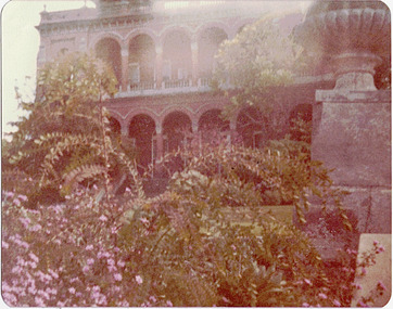
Photograph - 'Raheen', 96 Studley Park Road, 1979
The first section of Raheen was commenced in 1870 with an extension added in 1884. It was designed by William Salway and built for Edward Latham of the Carlton Brewery. Original colour positive photograph (Kodak print) of the garden on the west side of 'Raheen' in Studley Park Road, KewInk on reverse: "Raheen 1979 / Donated by M Rolley"raheen, 96 studley park road -- kew (vic.), historic gardens -- kew (vic.) -
 Kew Historical Society Inc
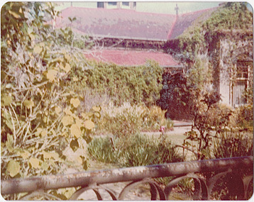
Photograph - 'Mynda', 5 Molesworth Street, 1979
'A suburban villa of 1885 designed by Lloyd Tayler for his daughter and son-in-law on a plan centred upon an octagonal top-lit hall. A square bay window to the drawing room projects from the front corner of the house at 45 degress, showing for the first time the diagonal emphasis which was to be developed in other works of the architect and to become in due course a characteristic of the Federation Style.' (National Trust Victoria Citation)Original colour positive photograph (Kodak print) of the front garden of 'Mynda', 5 Molesworth Street, KewInk on reverse: "Miss Anderson's / No.5 Molesworth St. / Cottage garden / Taken and ***"historic gardens -- kew (vic.), mynda, 5 molesworth street -- kew (vic.) -
![Wallpaper from 'Reno', St John's Parade [Kew]](/media/collectors/550653872162f11fb04854aa/items/57975996d0cdd1098c81d980/item-media/579759ded0cdd1098c81f6fa/item-fit-380x285.jpg) Kew Historical Society Inc
Kew Historical Society IncDecorative object - Wallpaper sample from 'Reno', St John's Parade, 1890s
Comparatively few weatherboard houses in Kew survived from the early years of settlement into the second half of the 20th century. One such property was ‘Reno’, which once stood on the east side of St John’s Parade. Its earliest recorded owner was the architect Samuel Cocking who lived there from c.1865 until his death in 1888. The original landholding was bordered by Cotham Road, Glenferrie Road, Wellington Street, and Charles Street. The southern portion of this land included a fine orchard, with many imported trees. The old summer house, at first in the orchard, was later removed to the house garden. The MMBW Detail Plan No.1576 (1904) shows the remaining portion of the original land holding, including a semi-circular pathway at the front, and garden features such as an aviary, a fountain and grotto, and a fernery. None of these are apparent in photographs dating from the 1960s, where the garden, which once included rare plants provided by Baron Von Mueller, surrounds the cottage in a tangled frenzy. Despite a ‘local significance’ classification by the National Trust, the house was demolished in 1977. Wallpaper fragment from ‘Reno’. This small fragment of floral wall paper is a bolder design than the delicately drawn flowers in 1977.0005.1. The flowers in this example were impressionistically created using printing blocks that allowed for different thicknesses of paint to be applied in the hand-blocking process. wallpaper, reno, st john's parade, kew -
![Wallpaper fragment - Reno, St John's Parade [Kew]](/media/collectors/550653872162f11fb04854aa/items/57975cd6d0cdd1098c838ddb/item-media/57975d42d0cdd1098c83c222/item-fit-380x285.jpg) Kew Historical Society Inc
Kew Historical Society IncDecorative object - Wallpaper sample from 'Reno', St John's Parade, 1870s
Comparatively few weatherboard houses in Kew survived from the early years of settlement into the second half of the 20th century. One such property was ‘Reno’, which once stood on the east side of St John’s Parade. Its earliest recorded owner was the architect Samuel Cocking who lived there from c.1865 until his death in 1888. The original landholding was bordered by Cotham Road, Glenferrie Road, Wellington Street, and Charles Street. The southern portion of this land included a fine orchard, with many imported trees. The old summer house, at first in the orchard, was later removed to the house garden. The MMBW Detail Plan No.1576 (1904) shows the remaining portion of the original land holding, including a semi-circular pathway at the front, and garden features such as an aviary, a fountain and grotto, and a fernery. None of these are apparent in photographs dating from the 1960s, where the garden, which once included rare plants provided by Baron Von Mueller, surrounds the cottage in a tangled frenzy. Despite a ‘local significance’ classification by the National Trust, the house was demolished in 1977. Wallpaper fragment from ‘Reno’. These three boldly designed samples from a single room are in shades of green and brown, highlighted by yellow and red floral sprays. While more accurately printed and coloured, the fragment lacks the freedom of design of the earlier samples.wallpaper, reno, st john's parade, kew, samuel cocking -
![Reno, St John's Parade [Kew] - Reno, St John's Parade [Kew]](/media/collectors/550653872162f11fb04854aa/items/57975dcbd0cdd1098c840aaf/item-media/57975e31d0cdd1098c84343d/item-fit-380x285.jpg) Kew Historical Society Inc
Kew Historical Society IncDecorative object - Wallpaper samples from 'Reno', St John's Parade, 1880-1910
Comparatively few weatherboard houses in Kew survived from the early years of settlement into the second half of the 20th century. One such property was ‘Reno’, which once stood on the east side of St John’s Parade. Its earliest recorded owner was the architect Samuel Cocking who lived there from c.1865 until his death in 1888. The original landholding was bordered by Cotham Road, Glenferrie Road, Wellington Street, and Charles Street. The southern portion of this land included a fine orchard, with many imported trees. The old summer house, at first in the orchard, was later removed to the house garden. The MMBW Detail Plan No.1576 (1904) shows the remaining portion of the original land holding, including a semi-circular pathway at the front, and garden features such as an aviary, a fountain and grotto, and a fernery. None of these are apparent in photographs dating from the 1960s, where the garden, which once included rare plants provided by Baron Von Mueller, surrounds the cottage in a tangled frenzy. Despite a ‘local significance’ classification by the National Trust, the house was demolished in 1977.Wallpaper fragment from ‘Reno’. These two large fragments of wallpaper have a formality of design that is accentuated by the wide borders and narrow vertical lines that separate the repeated designs of rose garlands in vases on a vertical trellis design. The design is in tones of pink and green with gilding.reno, st john's parade, kew, samuel cocking, wallpaper -
![Wallpaper from 'Reno', St John's Parade [Kew]](/media/collectors/550653872162f11fb04854aa/items/57975eabd0cdd1098c846619/item-media/57975ee7d0cdd1098c8484f7/item-fit-380x285.jpg) Kew Historical Society Inc
Kew Historical Society IncDecorative object - Wallpaper samples from 'Reno', St John's Parade, 1880-1914
Comparatively few weatherboard houses in Kew survived from the early years of settlement into the second half of the 20th century. One such property was ‘Reno’, which once stood on the east side of St John’s Parade. Its earliest recorded owner was the architect Samuel Cocking who lived there from c.1865 until his death in 1888. The original landholding was bordered by Cotham Road, Glenferrie Road, Wellington Street, and Charles Street. The southern portion of this land included a fine orchard, with many imported trees. The old summer house, at first in the orchard, was later removed to the house garden. The MMBW Detail Plan No.1576 (1904) shows the remaining portion of the original land holding, including a semi-circular pathway at the front, and garden features such as an aviary, a fountain and grotto, and a fernery. None of these are apparent in photographs dating from the 1960s, where the garden, which once included rare plants provided by Baron Von Mueller, surrounds the cottage in a tangled frenzy. Despite a ‘local significance’ classification by the National Trust, the house was demolished in 1977. Wallpaper fragment from ‘Reno’. This small fragment is part of the larger design shown in the previous sample (1971.0002.5). It includes a detail of the trellis element from the larger scheme.wallpaper, samuel cocking, reno, st john's parade, kew -
 Kew Historical Society Inc
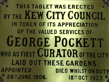
Plaque, City of Kew, George Pockett, First Curator of the City of Kew, 1922
George Pockett was first curator of the Alexandra Gardens in Kew. He and his brother were responsible for the design of a number of important municipal gardens.Brass memorial plaque to George Pockett. Originally located on Jubilee Rotunda in Alexandra Gardens.This Tablet was Erected / by the Kew City Council / in Token of its Appreciation of the Valued Services of George Pockett who as First Curator of the City Laid out these Gardens. Appointed 26th June 1906. Died Whilst on Duty, 18th October 1922.george pockett, alexandra gardens -
 Kew Historical Society Inc
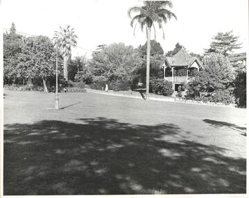
Photograph, Alexandra Gardens, c.1960
Rotunda, Alexandra Gardens (1910-c.1960). The Alexandra Gardens’ rotunda was located within three acres of ‘gem like’ gardens ‘bright with verdant lawns and choice blooms’ in the centre of Kew. Designed by architects Grainger and Little, the ornate two-storey wooden kiosk functioned as a children’s shelter on the ground level and a bandstand and oratory dais on the upper. Funded by council and community subscription, it was a ‘symbol of the public spirit of Victoria’ and a Kew Jubilee commemoration memorial. Opened in 1910, the Kew Brass Band christened it the ‘finest band rotunda in Melbourne’. Deterioration saw its demise 50 years later. This work forms part of the collection assembled by the historian Dorothy Rogers, that was donated to the Kew Historical Society by her son John Rogers in 2015. The manuscripts, photographs, maps, and documents were sourced by her from both family and local collections or produced as references for her print publications. Many were directly used by Rogers in writing ‘Lovely Old Homes of Kew’ (1961) and 'A History of Kew' (1973), or the numerous articles on local history that she produced for suburban newspapers. Most of the photographs in the collection include detailed annotations in her hand. The Rogers Collection provides a comprehensive insight into the working habits of a historian in the 1960s and 1970s. Together it forms the largest privately-donated collection within the archives of the Kew Historical Society.Lawn and original rotunda in the Alexandra Gardens, Cotham Road, Kew. The Alexandra Gardens were opened in 1908. The land on which the gardens were formed originally formed part of the Madford Estate. A feature of the gardens was a large brick, wood and tiled rotunda. "Alexandra Gardens. Formerly part of S. King. (Rest of Estate mainly belongs to St Anthonys home). Opened 1908. Alexandra Gardens. (Rotunda now demolished)"alexandra gardens, kew, dorothy rogers -
 Kew Historical Society Inc
Plan, Studley Heights Estate, 1936
Pru Sanderson, in her groundbreaking ‘City of Kew Urban Conservation Study : Volume 2 - Development History’ (1988), summarised the periods of urban development and subdivisions of land in Kew. The periods that she identified included 1845-1880, 1880-1893, 1893-1921, 1921-1933, 1933-1943, and Post-War Development. These periods were selected as they represented periods of rapid growth or decline in urban development. An obvious starting point for Sanderson’s groupings involved population growth and the associated economic cycles. These cycles also highlighted urban expansion onto land that was predominantly rural, although in other cases it represented the decline and breakup of large estates. A number of the plans in the Kew Historical Society’s collection can also be found in other collections, such as those of the State Library of Victoria and the Boroondara Library Service. A number are however unique to the collection.Subdivision plans are historically important documents used as evidence of the growth of suburbs in Australia. They frequently provide information about when the land was sold on which a built structure was subsequently constructed as well as evidence relating to surveyors and real estate and financial agents. The numerous subdivision plans in the Kew Historical Society's collection represent working documents, ranging from the initial sketches made in planning a subdivision to printed plans on which auctioneers or agents listed the prices for which individual lots were sold. In a number of cases, the reverse of a subdivision plan in the collection includes a photograph of a house that was also for sale by the agent. These photographs provide significant heritage information relating house design and decoration, fencing and household gardens.The ‘Studley Heights Estate’ on the South Side of Studley Park Road was launched in 1936. The seventeen allotments in the subdivision fronted Hyton Crescent and Studley Park Road.subdivision plans - kew, studley heights estate -
![Monnington [Estate], 1935](/media/collectors/550653872162f11fb04854aa/items/5907eb86d0ce0c14e82385c8/item-media/5907ecafd0ce0c14e823e87f/item-fit-380x285.jpg) Kew Historical Society Inc
Kew Historical Society IncPlan - Subdivision Plan, Monnington [Estate], 1935, 1935
Pru Sanderson, in her groundbreaking ‘City of Kew Urban Conservation Study : Volume 2 - Development History’ (1988), summarised the periods of urban development and subdivisions of land in Kew. The periods that she identified included 1845-1880, 1880-1893, 1893-1921, 1921-1933, 1933-1943, and Post-War Development. These periods were selected as they represented periods of rapid growth or decline in urban development. An obvious starting point for Sanderson’s groupings involved population growth and the associated economic cycles. These cycles also highlighted urban expansion onto land that was predominantly rural, although in other cases it represented the decline and breakup of large estates. A number of the plans in the Kew Historical Society’s collection can also be found in other collections, such as those of the State Library of Victoria and the Boroondara Library Service. A number are however unique to the collection.Subdivision plans are historically important documents used as evidence of the growth of suburbs in Australia. They frequently provide information about when the land was sold on which a built structure was subsequently constructed as well as evidence relating to surveyors and real estate and financial agents. The numerous subdivision plans in the Kew Historical Society's collection represent working documents, ranging from the initial sketches made in planning a subdivision to printed plans on which auctioneers or agents listed the prices for which individual lots were sold. In a number of cases, the reverse of a subdivision plan in the collection includes a photograph of a house that was also for sale by the agent. These photographs provide significant heritage information relating house design and decoration, fencing and household gardens.The first subdivision of Monnington took place in 1935. At that time, Monnington and 10 new allotments were offered for sale bordering Adeney and Marshall Avenues. In this subdivision plan, Monnington is one of 13 lots for sale. The subdivision created the irregular land holding of Monnington today. The excision of southwest corner of Monninton was caused by the need to have regular allotments facing the curve in Marshall Avenue.monnington - adeney avenue -- kew (vic.), subdivision plans -- kew (vic.)