Showing 586 items
matching geology collection
-
 Bendigo Historical Society Inc.
Document - MCCOLL, RANKIN AND STANISTREET COLLECTION: THE SEDGWICK GOLD MINE, 1930's
Manilla Folder containing documents relating to the Sedgwick Gold Mine, formerly the Great Eastern. Including plan of area applied for lease No. 10414 by E. Peel. Comprehensive hand written description of mine from R. M. Williams. And record taken from the Bendigo office by J. Caldwell, Field GeologistMcColl Rankin & Stanistreetgold mining, miners' safety cage, sedgwick, gold mine, sedgwick, great eastern, geology -
 Bendigo Historical Society Inc.
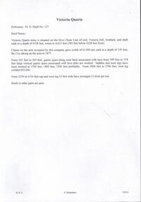
Document - VICTORIA QUARTZ - BRIEF NOTES ON THE VICTORIA QUARTZ MINE
Handwritten notes on the Victoria Quartz Mine. Notes mention locality, depth, geological information, Dividends, Calls and the Victoria Reef Tribute. Document from Albert Richardson Collection of mining history.document, gold, victoria quartz, victoria quartz, brief notes on the victoria quartz mine, victoria reef quartz shaft no 127, vict reef q m coy, mines dept, bendigo advertiser, victoria reef tribute -
 Bendigo Historical Society Inc.
Document - MCCOLL, RANKIN AND STANISTREET COLLECTION: REPORT ON CASTLEMAINE, MALDON & OTHER AREAS
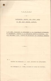
Copy of a typewritten report on Castlemaine, Maldon, and other areas of the main Bendigo District by H.W. Gepp Consultant on Development to the Commonwealth Government. W. Baragwanath Director of the Geological Survey of Victoria and F.L. Stillwell D.Sc. Council for Scientific and Industrial Research. Mentions Castlemaine, Fryertown, Maldon, South German Mine, Mt. Tarrengower Tunnel, Raywood, Sebastian, Wedderburn, Inglewood, Whipstick, Lightning Hill, Black Forest Mine, Old Tom Mine. Trentham. Dated 17th September 1931. Consists of 19 Foolscap PagesH.W. Gepp, W. Baragwanath, F.L. Stillwell.gold, mining, report, gold mining, bendigo, castlemaine, maldon -
 Bendigo Historical Society Inc.
Map - GOLDEN SQUARE GEOLOGICAL SURVEY, 1992
... BHS Collection BENDIGO Gold mining geological survey Dept ...BHS CollectionGolden Square Geological Survey of Goldfields Coloured map.Dept of manufacturing and Industry Development.bendigo, gold mining, geological survey -
 Bendigo Historical Society Inc.
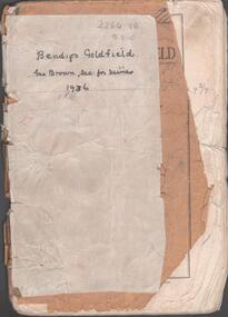
Booklet - Albert Richardson Collection: Bendigo Goldfield, MInes Department, Victoria 1936, 1936
Albert Richardson was an expert on the history of the Bendigo Goldfield. The Albert Richardson Park at Victoria Hill, is named in his honour. He was a prominent member of the Bendigo Historical Society. Fifty one page booklet. On front page: Bendigo Goldfield, issued by Geo Brown, Secretary for Mines, under the authority of The Hon. E.J. Hogan, M.L.A., Minister of Mines. Mines Department, Melbourne, Victoria, Australia, 1936.Content includes: historical information; recent development and future prospects, geology and lines of reef. Reef lines described are: Tysons, Lightning Hill, Hustlers, Derby, Paddy's Gully, Garden Gully, Deborah, Sheepshead, New Chum, Nell Gwynne, British and Foreign, Napoleon, Lancashire, Carshalton, Thistle, Christmas and Birds. On front cover 'Bendigo Goldfield, Geo Brown, Sec. for Mines, 1936' written in black pen. On first page 'A.Richardson, 29 Harrison Street, Bendigo' The booklet is annotated throughout by Albert Richardson, for example, the mines along the New Chum Line are further described with their date of formation, sill heights and area of claim.albert richardson, gold mining, goldfield, reef lines, 1936 -
 Bendigo Historical Society Inc.
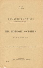
Document - MCCOLL, RANKIN AND STANISTREET COLLECTION: THE REDESDALE GOLDFIELD, 1909
1909 report from the Department of Mines Geological Survey on the Redesdale Goldfield by E. J. Dunn. F.G.S. Reefs mentioned are the Horseshoe Bend Reef, Linda Reef, Bill Smith's workings, the Ben Guy Reef and the Amelia ReefDepartment of Minesgold mining, miners' safety cage, redesdale goldfield, gold mining, redesdale. -
 Bendigo Historical Society Inc.
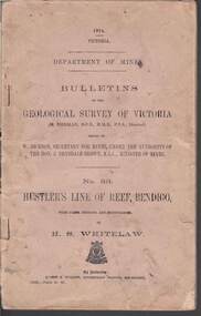
Book - STRUGNELL COLLECTION: DEPARTMENT OF MINES: 1914 GEOLOGICAL SURVEY OF VICTORIA. HUSTLERS LINE OF REEF, 1914
Book, Department of Mines, Bulletins of the Geological Survey of Victoria, No.33, Hustler's Line Of Reef, Bendigo, with plans,sections, and photographs, by H.S.Whitelaw. 13833, Price 2s.6d.`Back cover shows J.A. and J.A Strugnell , 12 Mulbar St Swan Hill 3585 .Albert J. Mullett, Government Printer, Melbourne.book, bendigo, hustler's line of reef -
 The Beechworth Burke Museum
Geological specimen - Olivine Crystals, Unknown
... . This specimen is part of a larger collection of geological and mineral ...Olivine is mostly found on the Earth's surface in igneous rocks that are dark-coloured. It is common at divergent plate boundaries and at warm spots, such as volcanic areas. It crystalises and forms during the cooling of magma. Olivine is used in refractory sand, bricks, and gemstones. Olivine has been found on a number of meteorites, which might have originated from large asteroids or the mantle of a now-destroyed planet. This olivine crystal is thought to originate from Mount Noorat, with speculation that it could have originated from Mount Shadwell. Mount Noorat is a dormant volcano cone located in the Newer Volcanics Province of Victoria. Mount Noorat belongs to the Kirrae Wuurong people, who used the Mount as a place for meetings and gatherings prior to European settlement. Contact was first made between European settlers and the Indigenous people in 1841. The Mount has mostly been used for cattle and sheep grazing. Mount Shadwell is a well-known source of olivine and is the highest of a gathering of volcanic cones. The New Volcanic Province is located in South East Australia and covers 15000 square kilometres. It contains 400 explosive vents and small shield volcanoes. The last eruption is thought to have occurred 5000 years ago at Mount Gambier and Mount Schank. This olivine crystal has been identified as a volcanic bomb, which is a molten rock which was pushed out and ejected into the air when a volcano reupts. A rock needs to be larger than 65 mm in diameter to be classified as a volcanic bomb. This olivine volcanic bomb and its locality is historically and socially significant. The olivine was found in the Newer Volcanic Province, an area which contains over 400 dormant volcanoes. This olivine is one part of a volcanic bomb, which would have ejected when magma erupted out of a volcano. This specimen is part of a larger collection of geological and mineral specimens collected from around Australia (and some parts of the world) and donated to the Burke Museum between 1868-1880. A large percentage of these specimens were collected in Victoria as part of the Geological Survey of Victoria that begun in 1852 (in response to the Gold Rush) to study and map the geology of Victoria. Collecting geological specimens was an important part of mapping and understanding the scientific makeup of the earth. Many of these specimens were sent to research and collecting organisations across Australia, including the Burke Museum, to educate and encourage further study.A solid iron-magnesium silicate mineral with shades of green and brownburke museum, beechworth, geological, geological specimen, olivine, igneous rock, volcanic, gemstones, volcanic bomb, meteorites, asteroids, plantes, mount noorat, mount shadwell, indigenous, kirrae wuurong people, newer volcanics province, victoria, european settlement, eruption -
 The Beechworth Burke Museum
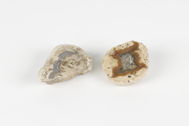
Geological specimen - Thunderegg agates, Unknown
... abundant. This specimen is part of a larger collection ...Thunderegg Agates are formed within rhyolite volcanic ash layers. They are rough spherical shapes, varying in size from less than an inch to over a metre long. Thundereggs usually contain centres of chalcedony which may have been fractured followed by deposition of agate, jasper or opal, either uniquely or in combination. A unique characteristic that these specimens have is the fact that they often look like ordinary rocks on the outside, but slicing them in half and polishing them may reveal intricate patterns and colours. These particular specimens are examples of thunderegg agates. Agate is a variety of chalcedony, a cryptocrystalline form of quartz. The agate component contributes to the intriguing internal patterns of the specimens. The specific locality of these specimens is unknown but they can be found in flows of rhyolite lava. They are formed in gas pockets in the lava, which act as moulds. These specimens can be found globally, with specific locations in Germany being particularly abundant. This specimen is part of a larger collection of geological and mineral specimens collected from around Australia (and some parts of the world) and donated to the Burke Museum between 1868-1880. A large percentage of these specimens were collected in Victoria as part of the Geological Survey of Victoria that begun in 1852 (in response to the Gold Rush) to study and map the geology of Victoria. Collecting geological specimens was an important part of mapping and understanding the scientific makeup of the earth. Many of these specimens were sent to research and collecting organisations across Australia, including the Burke Museum, to educate and encourage further study.Two small solid specimens with pale, sandy-coloured exteriors and fractured internal patterns. burke museum, beechworth, geological, geological specimen, thundereggs, thundereggs agate, agate, rhyolite, rhyolite lava, volcanic ash, chalcedony, cryptocrystalline -
 The Beechworth Burke Museum
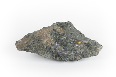
Geological specimen - Mangan Hedenbergite
... is part of a larger collection of geological and mineral specimens ...This specimen was recovered from Broken Hill, NSW. It was given the name Mangan Hedenbergite in 1819 by Jöns Jakob Berzelius in honor of Mr. Anders Ludvig of Hedenberg who was the first to define hedenbergite as a mineral. Hedenbergite, belongs in the pyroxene group having a monoclinic crystal system. The mineral is extremely rarely found as a pure substance. Mangan Hedenbergite is a manganese bearing variety of Hedenbergite. Manganese is the world’s fourth most used mineral after iron, aluminium, and copper primarily because it has no satisfactory substitute in its major applications. Globally, the steel industry is the primary user of manganese metal, utilizing it as an alloy to enhance the strength and workability of steel and in the manufacture of tin cans. Manganese is a key component of certain widely used aluminium alloys and, in oxide form, dry cell batteries used in electric vehicles. These batteries are in high demand. Another potential use for manganese may as an additive to help coat and protect a car’s engine. Manganese is also used for non-metallurgical purposes such as plant fertilizers, animal feed, and colorants for bricks. This specimen is part of a larger collection of geological and mineral specimens collected from around Australia (and some parts of the world) and donated to the Burke Museum between 1868-1880. A large percentage of these specimens were collected in Victoria as part of the Geological Survey of Victoria that begun in 1852 (in response to the Gold Rush) to study and map the geology of Victoria. Collecting geological specimens was an important part of mapping and understanding the scientific makeup of the earth. Many of these specimens were sent to research and collecting organisations across Australia, including the Burke Museum, to educate and encourage further study.A hand-sized mineral specimen in shades of silver and blackmanganese, open cut mine, manganese ore processing, bell bay, tasmania, northern territory, steel industry, zinc-carbon batteries, alkaline batteries, tin cans -
Bendigo Historical Society Inc.
Map - STRUGNALL COLLECTION: BENDIGO GOLD FIELD GEOLOGICAL SURVEY, 1936
... BHS Collection BENDIGO Gold mining geological map Dept ...BHS CollectionBendigo Goldfieds Geological Survey. Prepared in the Bendigo Office Lower Section of original map. Note with map says other items donated - yet to be catalogued. TO BE FOUNDDept of Mines Victoriabendigo, gold mining, geological map -
Bendigo Historical Society Inc.
Map - STRUGNELL COLLECTION: BENDIGO GOLD FIELD GEOLOGICAL SURVEY, 1936
... BHS Collection BENDIGO Gold mining geological map Dept ...BHS CollectionBendigo Goldfieds Geological Survey. Prepared in the Bendigo Office Top Section of original map.Dept of Mines Victoriabendigo, gold mining, geological map -
 Bendigo Historical Society Inc.
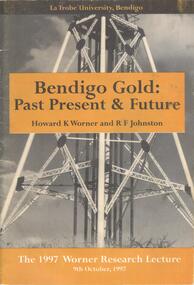
Document - BOOKLET: BENDIGO GOLD: PAST PRESENT & FUTURE - THE 1997 WORNER RESEARCH LECTURE, 1997
BHS CollectionSoftcover booklet produced for the 1997 Worner Research Lecture 9 October 1997. Cover contains black and white photograph of a poppet head, with gold coloured inserts bearing the title, authors and date. 29 pages with the contents of the lecture together with illustrations and photographs. Lecture covered the history and geology and the refractory gold ores.Published by Lat Trobe University Authors Howard K Worner and R F Johnston.bendigo, gold mining -
 Bendigo Historical Society Inc.
Administrative record - South Nell Gwynne G.M. Co. N.L. Share Register, 1939 to 1941
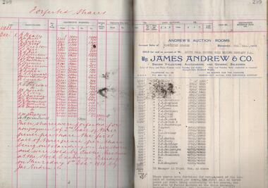
See Geological Survey Victoria: GSV Reference ID: 43711 South Nell Gwynne 'The Central Nell Gwynne which recently took over the reef prospected by Nell Gwynne ( B.M.L.) will continue to work the mine until the new Company, South Nell Gwynne Gold Mining Company is ready to take over. The main development work is at the 1080 feet level where stoping is being carried out on a spur system which has shown several colours of gold. ...The trial crushing in shaft sinking gave 4 dwt per gold per ton..... ' ( 29th July 1938, 'The Herald, Melbourne) 1941 Geological Survey Vic: SOUTH NELL GWYNNE, BENDIGO. MINING AND GEOLOGICAL JOURNAL: ' Journal, dark green hard cover, buff bindings on spine and corners. On spine of book in gold print: ' Share Register South Nell Gwynne G.M. Co. N.L.' South Nell Gwynne Gold Mining Company share register, 1938 to 1941. Alphabetical index in front, four hundred pages. Entries detail date of purchase, name of shareholder, distinctive number range, call account and paid by. Page 299 has a list of forfeited shares in the Company with a list of shares sold by James Andrew & Co., on 8th December 1938. Shares were 'forfeited for non payment of the 2nd call of threepence per share'. Share register is part of the Margaret Roberts Collection. bendigo, goldmining, goldfield, south nell gwynne gold mining co., nell gwynne, margaret roberts collection, mr j.j. stanistreet, mine manager -
Bendigo Historical Society Inc.
Map - STRUGNELL COLLECTION: BENDIGO GOLD FIELD GEOLOGICAL SURVEY, 1936
... BHS Collection BENDIGO Gold mining geological map Dept ...BHS CollectionBendigo Goldfieds Geological Survey. Prepared in the Bendigo Office Bottom Section of original map.Dept of Mines Victoriabendigo, gold mining, geological map -
 Eltham District Historical Society Inc
Book, Jenny Brown et al, Out of the Mist; Osborne Peninsula, 2024
The Osborne Peninsula on the Yarra River at Warrandyte accommodates a limited number of properties and residents (70 households). The area is rich in geology and ecology, and an unusually rich endowment of human, built and creative history. Contents: Welcome: The landform: The River: Aboriginal occupation: The Miners: North Warrandyte :The Subdivision: The Lowes: The Osbornes: The Last Osborne: The Elders: The Relics: Dray Track: Water Wheel"Kauri Plaque: River track: Pines: Windmill Creek Bridge: The Koornong School: The Houses" Man Cave: MidCentury Classic: Enduring Original" Masterwork: The Muddies: The State Park: The Saving of Koornong Reserve: The Landcare Story: Flora and Fauna: The Vulnerable, Endangered and threatened: Birds: Mammals: "Waring" the wombat: Reptiles: Fish: Invertebrates: Flora: Fire. Published by the North Warrandyte (Osborne Peninsula) Landcare Group. Includes photos from EDHS collection.64 p. : ill., map ; 29.7 x 21 cm. (2 copies)yarra river, birrarung, dray track, fauna, geology, houses, indigenous history, koornong reserve, koornong school, lowe family, mining, mudbrick houses, north warrandyte, osborne family, warrandyte state park, water wheel, north warrandyte (osborne peninsula) landcare group, osborne peninsula