Showing 963 items
matching main hall
-
 Ringwood and District Historical Society
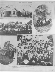
Photograph, Photographs from Grand Fancy Fair in aid of the new Hall at Ringwood, 1909 (Weekly Times)
Weekly Times Page with 5 photographs, dated. October 2, 1909 with main subtitle of "Grand Fancy Fair in aid of the new Hall at Ringwood".The five pictures are described as follows, '1. The New Mechanics' Hall. 2. Some of the "aboriginals". 3. Bush Drama-Black attacking the camp. 4. Spectators watching the display. 5. Group of stall-holders.' -
 Ringwood and District Historical Society
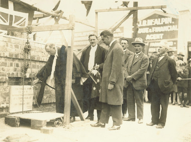
Photograph, Mayor A.T. Miles laying foundation stone of the Ringwood town hall - Corner of Main Street and Melbourne Street 19.2.1927
... town hall - Corner of Main Street and Melbourne Street... stone of the town hall - Corner of Main Street and Melbourne..., 'Mayor A.T. Miles laying stone of town hall, C/r Main St ...Typed below photograph, 'Mayor A.T. Miles laying foundation stone of the town hall - Corner of Main Street and Melbourne Street 19.2.1927'. Written on backing, 'Mayor A.T. Miles laying stone of town hall, C/r Main St. & Melbourne St. 19.2.1927. A.T.M., Long, Town Clerk, A.C. Leith, Architect, J. Roberts, Builder, and J. Hyden from Lilydale.' -
 Orbost & District Historical Society
black and white photographs, first half 20th century
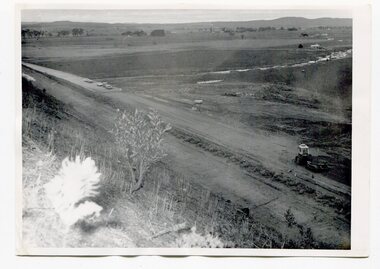
3255.1 is a photograph of the Princes Freeway construction of the roadway embankment at the foot of Newmerella Hill. 3255.2 is of the construction of the roadway, the Princes Freeway looking down from Newmerella toward Orbost. 3255.3 shows the Princes Freeway from Grandview , Newmerella, and shows the southern end of Ashby's Gulch with its bridge. 3255.4 is of the Princes Freeway showing the bridge across Ashby's Gulch and a train on the railway viaduct. Ashby's Gulch is named for the Ashby family. The Ashby family was one of the early settlers in Orbost at Newmerella. Roy Ashby, son of James Rowland Ashby and Edith Annie Hall, was born on 21 Nov 1892 in Orbost. Victoria. Australia and died in 1942 in Orbost. Victoria. Australia at age 50. Roy married Elsie May Stephens, daughter of James Stephens and Sarah Taylor, in 1920 in Victoria.Australia. Elsie was born on 15 Sep 1898 in Beaconsfield Tasmania.Australia and died in 1974 in Orbost Australia at age 76. Their children were: Roy Ashby, William Henry Ashby, Cordelia Valma Ashby and Edith Ashby. This photograph is associated with the construction of the main roads into Orbost. It is also connected to the Orbost to Bairnsdale Railway.Four black / white photographs of road construction and rail bridges.road-construction-newmerella princes-freeway-newmerella ashby's-gulch-newmerella orbost-railway -
 Orbost & District Historical Society
black and white photograph, 1. 12. 1973
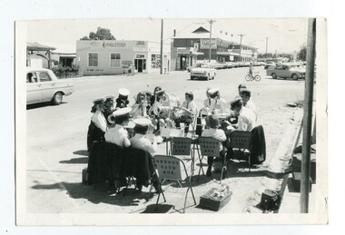
This photograph was published in the Snowy River Mail on November 27 1974. "Shoppers in Nicholson Street, Orbost, have been treated to band music each Saturday morning when members of Orbost Municipal Band have rendered items in the shopping centre. Members, both senior and junior, are pictured here as they prepare instruments for a recital on a sunny Saturday." The photograph was taken by Peter Fagg in Nicholson Street on the corner of Wolseley Street on Saturday morning 1.12.1973. The first Orbost Brass Band was formed in 1889. Around 1908 the town band split and the Orbost Workers' Band was formed. Eventually the two bands merged in 1913 to reform as the Orbost Municipal Band under conductorship of Charles Spink. The band continued for many years but was later disbanded and again reformed. This was to happen a number of times, the last time being in 1961 and continuing through to the late 1970's. Further info and Ref: In Times Gone By - Deborah Hall This is a pictorial record of the Orbost Municipal Band. The various Orbost bands over the years played a major role in community activities providing entertainment and musical experiences for the many members.A black / white photograph of a group,of uniformed band members sitting in a circle at the edge of a main street. Each is holding a musical instrument with music stands in front of them.music-orbost orbost municipal band recreation entertainment -
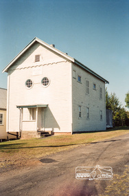
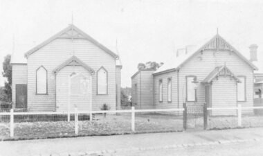 Ringwood and District Historical Society
Photograph, Ringwood Methodist Church on site at Cnr. Melbourne St. and Whitehorse Rd 1904
Written on backing sheet, "Methodist Church on site at Cnr. Melbourne St. and Whitehorse Rd. On its removal to Greenwood Ave. Mr. J.B. McAlpin built shops on this site - land (Dimmey's) including his own estate agency." One photograph claimed church was moved to Greenwood Ave in 1916. Photograph taken in 1904. Another photograph states that the photograph is of the Methodist Church and Sunday School. Inserted in the sleeve of one of the photographs are two small postcard photographs that state they are, "Methodist Church in Main Street, Ringwood opposite railway station. See Mechanics Institute where Town Hall now stands - c1910. Photo by L. F. East". -
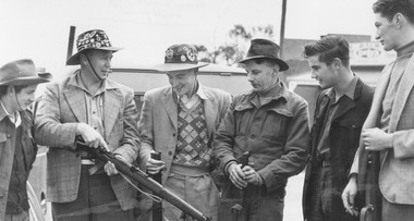 Ringwood and District Historical Society
Photograph, Ringwood Rifle Club. 'Mail' photo, 13/5/1954
Black and white photograph (2 copies)Written on back of one copy- "Ringwood Rifle Club. 'Mail' photo, 13/5/1954. L. to R. Vic Beveridge, Constable Bill Hall team captain, Frank Corr, Frank Phillips, Jim Walker and J. Wood". Written on back of second copy- "Ringwood Rifle Club met at corner Main St. and Warrandyte Rd. to proceed to range Jumping Creek Road, South Warrandyte. Const. W. Hall, Capt. 2nd from left." -
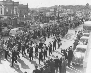 Ringwood and District Historical Society
Photograph, Pump, Brian, Coronation procession at Ringwood led by Ringwood Citizens Band - June, 1953
3 copies of Black and White Photograph of Band marching through main street of Ringwood. Written below photograph, '1953. Coronation Procession led by Citizens Band.' Backing sheet reads, 'Mail 11/6/53. Coronation procession at Ringwood led by Ringwood Citizens Band. The March is shown from the Fire Station to the Town Hall' -
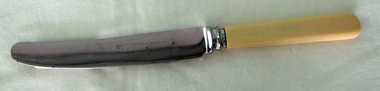 Orbost & District Historical Society
knife, C1920's -1950's
This knife was found in a drawer from the estate of Judy Walcott who died in 2016 in Orbost. The Dicken Bros, shop is in the main street of Orbost . Frank B. Dicken and his son, Selwyn, were General Merchants. Frank and May Dicken moved to Orbost in 1936 where Frank became manager of Pardew Brothers store in Nicholson Street. In 1945, Frank purchased the business and in 1947, formed a partnership with his son, Selwyn. The store was then called F.B. Dicken and Son. The premise are still retained by the Dicken family although the shop business was sold in 1981. (ref. In Times Gone By - Deborah Hall) This item is an example of an item produced for advertising and promotion. The Dicken General Merchandising business is no longer an Orbost feature.A bone handled butter knife with an inscription on one side of the blade. Handle is a cream bone with a rounded end. Stainless Steel Made in Sheffield Expressly fo F.B. Dicken & Son ORBOST -
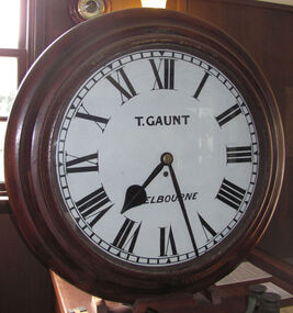 Flagstaff Hill Maritime Museum and Village
Instrument - Clock, c. 1860s
The clock was either made or sold by T. Gaunt & Co. of Melbourne, a manufacturer, importer and retailer of a wide variety of goods including jewellery, clocks and watches, navigational and measuring instruments, dinnerware, glassware and ornaments. Thomas Gaunt photograph was included in an album of security identity portraits of members of the Victorian Court, Centennial International Exhibition, Melbourne, 1888. Thomas Gaunt History: Thomas Gaunt established Melbourne's leading watchmaking, optical and jewellery business during the second half of the 19th century. Gaunt arrived in Melbourne in 1852, and by 1858 had established his own business at 14 Little Bourke Street. Around 1869 he moved to new premises in Bourke Street on the corner of Royal Arcade, Gaunt's shop quickly became a Melbourne institution. Gaunt proudly advertised that he was 'The only watch manufacturer in the Australian colonies'. While many watches and clocks may have had Gaunt's name on the dial, few would have been made locally. Gaunt did make some watches for exhibitions, and perhaps a few expensive watches for wealthy individuals. Gaunt's received a telegraph signal from Melbourne Observatory each day to correct his main clock and used this signal to rate and repair ship's chronometers and good quality watches. His main horological manufacturing was directed at turret clocks for town halls, churches and post offices. These tended to be specific commissions requiring individualised design and construction. He made the clock for the Melbourne Post Office lobby, to a design by Government Astronomer Robert Ellery, and won an award at the 1880-81 Melbourne International Exhibition for his turret clock for the Emerald Hill Town Hall. He became well known for his installation of a chronograph at Flemington Racecourse in 1876, which showed the time for the race, accurate to a quarter of a second. The firm also installed the clockwork and figures for Gog and Magog in the Royal Arcade. Thomas Gaunt also developed a department that focused on scientific instrumentation, making thermometers and barometers (from imported glass tubes), telescopes, surveying instruments and microscopes. Another department specialised in electroplating for trophies, awards and silverware, and the firm manufactured large amounts of ecclesiastical gold ware and silverware, for the church including St Patrick's Cathedral. There are no records that disclose the number of employees in the firm, but it was large enough for Gaunt to hold an annual picnic for the watchmakers and apprentices at Mordialloc from 1876; two years previously they had successfully lobbied Gaunt to win the eight hour day. Gaunt's workforce was reportedly very stable, with many workers remaining in the business for 15 to 30 years. Gaunt's wife Jane died on September 1894, aged 64. They had one son and six daughters, but only three daughters survived to adulthood. Two became nuns at the Abbotsford Convent and one daughter, Cecelia Mary Gaunt (died 28 July 1941), married William Stanislaus Spillane on 22 September 1886 and had a large family. Gaunt died at his home in Coburg, Victoria, leaving an estate valued at ₤41,453. The business continued as T. Gaunt & Co. after his death. Post Office and Clock History: Warrnambool’s Post Office has been in existence since 1857, when it was originally situated on the corner of Timor and Gilles Street. In March 1864 the Warrnambool Borough Council purchased this clock from Henry Walsh Jnr. for the sum of £25, “to be put up in front of the Post Office”. Henry Walsh Jnr was the eldest son of Melbourne’s Henry Walsh, maker and retailer of clocks, watches, thermometers and jewellery. In 1854 Henry Walsh Jnr. began business in Warrnambool as a watchmaker and jeweller later becoming a Councillor with now a local street named after him. The Post Office was extensively remodelled in 1875-76. Early photographs of this building show that the clock was installed on the northern outside wall, Timor Street, under the arches and between the 2 centre windows, where it could be seen by passers-by. Although spring loaded clocks date back to the 15th century, and fob and pocket watches evolving from these date to the 17th century, personal pocket watches were only affordable to the very fortunate. Public clocks such as this Post Office clock provided opportunity for all to know the time, and for those in possession of a personal watch to check and set their own timepieces to the correct time. During post office reservations during the 1970s the clock was removed and was eventually donated to the Flagstaff Collection. The Clock’s maker Thomas Gaunt, is historically significant and was an established and well renowned scientific instrument and clock maker in Melbourne during the 1860s. He was at that time the only watchmaker in the Australian colonies. In the 1870’s and 1880’s he won many awards for his clocks and was responsible for sending time signals to other clocks in the city and rural areas, enabling many businesses and organisations to accurate set their clocks each day. Warrnambool Borough Council purchased this clock from Henry Walsh Jnr. for the sum of £25 and the clock used to stand in front of the Warrnambool post office to allow ordinary citizens to set their time pieces as they walked by. The item is not only important because it was made by a significant early colonial clock maker and retailed by a locally known clock maker and jeweler but also that it was installed in the Warrnambool Post Office a significantly historical building in it's own right. Built in 1857 and regarded as one of the oldest postal facilities in Australia, with a listing on the National Heritage Database, (ID 15656). This 1864 hall clock originates from the Warrnambool Post Office. The clock glass is hinged to the top of the clock face and has a catch at the bottom. The metal rim of the glass is painted black. The clock face is metal, painted white, with black Roman numerals and markings for minutes and five minutes. The tip of the small hour hand is shaped like a leaf. "T. GAUNT / MELBOURNE" is printed in black on the clock face. The winding key hole is just below the centre of the clock face. The key winds a fusee chain mechanism, attached to the brass mainspring barrel that powers the pendulum with an 8-day movement. The speed of the clock can be adjusted by changing the position of the weight on the pendulum, lengthening or shortening the swing; raising the pendulum shortens its swing and speeds up the clock. The metal fusee mechanism has an inscription on it. The rectangular wooden casing is with a convex curve at the bottom that has a hinged door with a swivel latch. The original stained surface has been painted over with a matte black. There are two other doors that also allow access to the clock’s workings. The case fits over the pendulum and workings at the rear and attaches to the clock by inserting four wooden pegs into holes in the sides of the case then into the back of the clock. A flat metal plate has been secured by five screws onto the top of the case and a hole has been cut into it for the purpose of hanging up the clock. There is a nail inside the case, possibly used for a place to the key."T. GAUNT MELBOURNE" is printed on the clock face. “6 1 3” embossed on the back of the fusee mechanism behind the clock. warrnambool, shipwrecked coast, flagstaff hill, flagstaff hill maritime museum, maritime museum, shipwreck coast, flagstaff hill maritime village, shipwrecked artefact, clock, warrnambool post office, fusee, henry walsh jnr, thomas gaunt, t gaunt & co, post office clock -
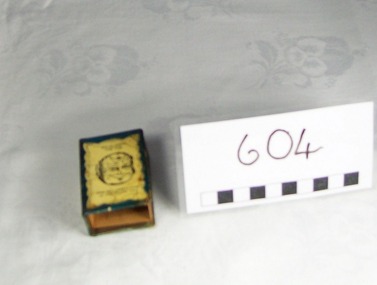 Blacksmith's Cottage and Forge
Matchbox and Matchbox Holder, Box : Bryant and May's, early 20th. century
The Bryant and May Factory is located in the suburb of Cremorne in Melbourne, Australia. It was constructed in 1909 as the Empire Works to a design by prolific Melbourne architect William Pitt. It was purchased soon after by British safety match manufacturer Bryant and May who significantly expanded the building adding an additional level and the landmark clock tower. Bryant and May were unique in that they operated as a model factory providing workers with conditions and amenities which even today seem generous. These included a dining hall and sports facilities such as a tennis court and bowling green which were constructed in the 1920s. Bryant and May ceased Australian match manufacture in the early 1980s as a result of import competition. Their iconic Redheads matches are now imported from Sweden. The complex has since been converted for use as offices and showrooms but is extremely well preserved. It is listed on the Victorian Heritage Register. Source: www.wikipedia.org Local social history of Bacchus MarshMetal matchbox holder for a matchbox-one side has a photo of a local cricket team, the other side has a caricature of a man's face when held one way up is smiling and when turned up the other way the face is looking unhappy. The cover is blue with yellow. The matchbox cover is made of a thin veneer wood. The makers inscription is in blue and red.Cover/spine: Strike The Border Inn Bacchus Marsh for a good spot Phone 16 Cyril Jones, Proprietor. Cover/side: This man always calls in at the Border Inn. This Man wishes he did Matchbox:Bryant & May's "Crown" Safety Matchesbox, souvenir, sport, item, cricket, match, team, cyril, jones, border, inn, cover, novelty -
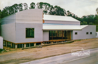
 Eltham District Historical Society Inc
Photograph, Demolishing the Bini Shell at Diamond Creek, 1991, 1991
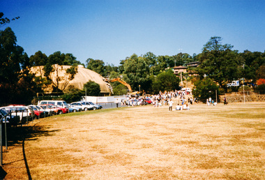
In 1978 Diamond Valley Shire recognised the need for a new public hall in Diamond Creek. Council considered the Bini shell form of construction which was in operation overseas and in use in New South Wales as libraries, gymnasiums, sports centres and multi-purpose centres. The Council gave the go-ahead. A site was chosen opposite the Hotel and close to the railway line. One day in - the following year, in 1979, activity stood still in Diamond Creek as school children and other excited spectators watched the one-hour inflation of the Bini Shell. This unusual method of construction was invented by Italian industrial designer and architect Dante Bini. The construction pneumatically raises a level of reinforced concrete from ground level which has not been set, using an internal balloon. The inner membrane inflates and compresses the mesh and concrete against the outer membrane. A net of flexible steel rods was laid on the building’s circular base, on the top of a fabric bladder. 300 tonnes of reinforced concrete were poured onto the mesh and a sealed cover laid over the concrete making a sandwich of cover, bladder and mesh. Compressed air was pumped into the bladder and the sandwich slowly began to rise and become a massive self-supporting dome. After inflation and removal of the outer membrane workmen filled in any holes. It was some days before pneumatic drills pecked out the first opening. The ceiling of the concrete dome was lined with fluffy insulating material. The dome was 36 metres in diameter at the base and 12 metres high in the centre with a usable floor space of 670 square metres. An opening night dinner was held to celebrate the new facility on March 12, 1980. Shire President Ron Pata made a speech and unveiled a plaque. It was the first public building in Victoria to be erected using the Bini Shell design method of construction The facility could cater for up to 400 people and in 1980 a fee for use was $100 for up to 200 people, $150 for up to 300 people and $200 for up to 400 people. For the next ten years or so, locals attended the hall for marital arts classes, basketball and netball games and school discoes and various other activities. After pieces of concrete fell off a Bini shell interstate due to a construction fault, the Council closed the centre. Demotion took place during the Diamond Creek Town Fair in 1991, as part of the annual Town Fair’s program. Research by L.P. Jan 2022This was the first public building in Victoria to be erected using the Bini Shell design method of construction.Colour photograph1991, diamond creek, bini shell, demolition, oval -
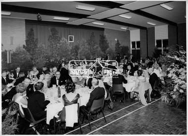 Eltham District Historical Society Inc
Photograph, Shire of Eltham Centenary Dinner, 6 Apr 1971
Guests seated at the Shire of Eltham Centenary Dinner in 1971. The tables dressed in white tablecoths surrounded by a display of greenery. The event was held in the West Riding Hall, Petrie Park Community Centre, Montmorency. This photo forms part of a collection of photographs gathered by the Shire of Eltham for their centenary project book, "Pioneers and Painters: 100 years of the Shire of Eltham" by Alan Marshall (1971). The collection of over 500 images is held in partnership between Eltham District Historical Society and Yarra Plenty Regional Library (Eltham Library) and is now formally known as 'The Shire of Eltham Pioneers Photograph Collection.' It is significant in being the first community sourced collection representing the places and people of the Shire's first one hundred years.Digital imagesepp, shire of eltham pioneers photograph collection, shire of eltham, shire of eltham centenary, official dinner, centenary celebrations, petrie park community centre montmorency -
 Eltham District Historical Society Inc
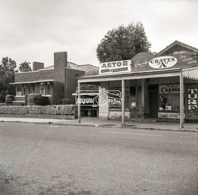
Negative - Photograph, Peter Bassett-Smith (poss), Shire of Eltham Office and Hall and adjacent shops, Main Road, Eltham, c.1961
... Shire of Eltham Office and Hall and adjacent shops, Main... a community hall. eltham main road arthur street council eltham hall ...Eltham Shire Offices 1941-1965, were located at the Corner of Arthur Street and Main Road, Eltham. The Building also incuded a community hall.Negative black and white film 120 6x6 format One of six frames (sectioned: three continuous, two single frames and one frame missing), and Associated black and white photo printeltham, main road, arthur street, council, eltham hall, eltham shire office, shire of eltham, astor radio & tv, eltham shire council, eltham shire hall, municipal offices, shire offices, shops -
 Eltham District Historical Society Inc
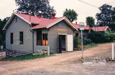
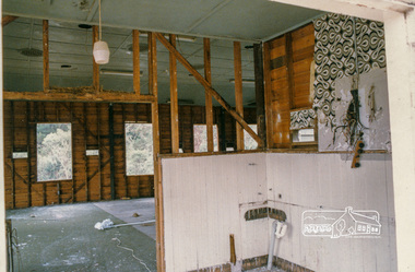
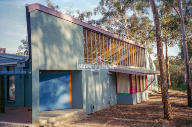
Photograph, Greg Marginson, Original hall of the Eltham Little Theatre under demolition, 1603 Main Road, Research, April 1987, 1987
In 1987 the old hall was demolished and a new building constructed which was opened in 1988.Colour photographdisplay panel, eltham little theatre, infrastructure, main road, research (vic.), demolition -
 Eltham District Historical Society Inc
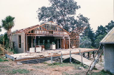
Photograph, The new home of Eltham Little Theatre under construction, 1603 Main Road, Research, c. Oct 1987, 1987
In 1987 the old hall was demolished and a new building constructed which was opened in 1988. Date based on other similar display panels visible in images of the Shire of Eltham display at the Eltham Community Festival, 7 November 1987.Colour photographdisplay panel, eltham little theatre, infrastructure, main road, research (vic.), building construction, eltham festival, shire of eltham -
 Eltham District Historical Society Inc
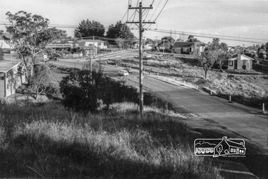
Photograph, Looking south along Para Road at intersection of Alma Street and Lees Road, Lower Plenty, c.July 1967, 1967
Old community hall (long wall with row of windows) and Lower Plenty Kindergarten visible at corner of Glenauburn and Para Roads. Packaged in "Filmpro King Size prints Definitely Better EST. 1918" envelope. Pencil notes: 36 shots $2.87 Eltham Shire J. McD and 19/7/67. Alma Street and Kett Street Lower Plenty c.July 1967.Black and white photographalma street, glenauburn road, carisbrook crescent, lees road, lower plenty, lower plenty kindergarten, para road, houses, streets -
 Eltham District Historical Society Inc
Negative - Photograph, Rear of Eltham North Hall, 1998c
Roll of 35mm colour negative film, 8 strips and associated 10 x 15 cm colour printKodak Gold 100-5eltham north, eltham north hall -
 Eltham District Historical Society Inc
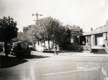
Photograph, Ian McDonald, Main Road, Eltham, corner of Arthur Street showing Shire Hall and Shire Office, 4 January 1968, 04/01/1968
... eltham eltham hall eltham shire office main road pph produce ...Note Cinema sign on hall.Black and white photographarthur street, dudley street, eltham, eltham hall, eltham shire office, main road, pph, produce paint and hardware centre, shire offices, shire of eltham pioneers photograph collection, woolworths, eltham fire brigade, fire station, sepp -
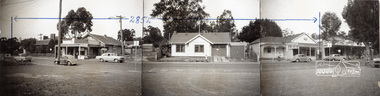 Eltham District Historical Society Inc
Photograph, Ian McDonald, Main Road, Eltham, between Arthur Street and Dudley Street, 4 January 1968, 04/01/1968
... of old Shire Office and Hall, former Fire Station, etc., Main ...Shows the 285 ft. frontage along Main Road consisting of old Shire Office and Hall, former Fire Station, etc., Main Road, Eltham, which was sold to Woolworths.Black and white photograph[Written on backing paper:] Shows area sold to Woolworths. I took these photos from the new fire station - the building in the middle is the old fire station - Moved to Research for Scouts 1970 - IMcDarthur street, dudley street, eltham, eltham hall, eltham shire office, main road, pph, produce paint and hardware centre, shire offices, shire of eltham pioneers photograph collection, woolworths, eltham fire brigade, fire station, sepp -
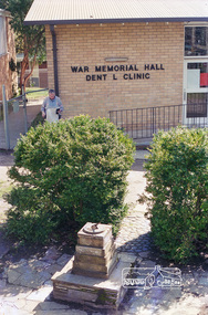 Eltham District Historical Society Inc
Negative - Photograph, Harry Gilham, Eltham War Memorial Hall Dental Clinic, Main Road, Eltham, c.Aug. 1996
... Eltham War Memorial Hall Dental Clinic, Main Road, Eltham... strips Eltham War Memorial Hall Dental Clinic, Main Road, Eltham ...Roll of 35mm colour negative film, 5 of 6 stripsKodak Gold 100-5dental clinic, eltham war memorial building, war memorial hall -
 Eltham District Historical Society Inc
Photograph, Fred Mitchell, Bini Shell at Diamond Creek, 1983, 1983
In 1978 Diamond Valley Shire recognised the need for a new public hall in Diamond Creek. Council considered the Bini shell form of construction which was in operation overseas and in use in New South Wales as libraries, gymnasiums, sports centres and multi-purpose centres. The Council gave the go-ahead. A site was chosen opposite the Hotel and close to the railway line. One day in - the following year, in 1979, activity stood still in Diamond Creek as school children and other excited spectators watched the one-hour inflation of the Bini Shell. This unusual method of construction was invented by Italian industrial designer and architect Dante Bini. The construction pneumatically raises a level of reinforced concrete from ground level which has not been set, using an internal balloon. The inner membrane inflates and compresses the mesh and concrete against the outer membrane. A net of flexible steel rods was laid on the building’s circular base, on the top of a fabric bladder. 300 tonnes of reinforced concrete were poured onto the mesh and a sealed cover laid over the concrete making a sandwich of cover, bladder and mesh. Compressed air was pumped into the bladder and the sandwich slowly began to rise and become a massive self-supporting dome. After inflation and removal of the outer membrane workmen filled in any holes. It was some days before pneumatic drills pecked out the first opening. The ceiling of the concrete dome was lined with fluffy insulating material. The dome was 36 metres in diameter at the base and 12 metres high in the centre with a usable floor space of 670 square metres. An opening night dinner was held to celebrate the new facility on March 12, 1980. Shire President Ron Pata made a speech and unveiled a plaque. It was the first public building in Victoria to be erected using the Bini Shell design method of construction The facility could cater for up to 400 people and in 1980 a fee for use was $100 for up to 200 people, $150 for up to 300 people and $200 for up to 400 people. For the next ten years or so, locals attended the hall for marital arts classes, basketball and netball games and school discoes and various other activities. After pieces of concrete fell off a Bini shell interstate due to a construction fault, the Council closed the centre. Demotion took place during the Diamond Creek Town Fair in 1991, as part of the annual Town Fair’s program. Research by LP January 2022This was the first public building in Victoria to be erected using the Bini Shell design method of construction.Digital copy of colour photographfred mitchell collection, 1983, bini shell, diamond creek -
 Eltham District Historical Society Inc
Photograph, Fred Mitchell, Jarrold Cottage, 5 September 2007
Three historically significant buildings are here at 701 Main Road, opposite Dalton Street, Eltham. Jarrold Cottage or White Cloud was built about 1863 and remains one of the oldest buildings in Eltham. It was once used temporarily as Eltham’s first police station. The Jarrolds were a pioneer family of market gardeners and building tradesmen over six decades and from the early 1940s, with the Skippers and other prominent local figures involved in the construction and development of the Montsalvat Artists' Colony. Len Jarrold, a carpenter, worked at Montsalvat from the beginning and became foreman of works for the splendid 1938 Great Hall. The Skipper family, also involved with Montsalvat, were associated with Jarrold Cottage from 1944 when it was purchased by Lena Skipper. Digital copy of colour photographfred mitchell collection, 2007, eltham, jarrold cottage, main road -
 Eltham District Historical Society Inc
Photograph, Masonic Hall, Eltham, NSW
Roll of 35mm colour negative film, 2 stripsFuji 100eltham (nsw) -
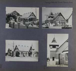 Glen Eira Historical Society
Album - Album page, Carnegie Methodist Church, Neerim Road, Circa 1972
... character of the main church and hall. Its historical value rests ...This photograph is part of the Caulfield Historical Album 1972. This album was created in approximately 1972 as part of a project by the Caulfield Historical Society to assist in identifying buildings worthy of preservation. The album is related to a Survey the Caulfield Historical Society developed in collaboration with the National Trust of Australia (Victoria) and Caulfield City Council to identify historic buildings within the City of Caulfield that warranted the protection of a National Trust Classification. Principal photographer thought to be Trevor Hart, member of Caulfield Historical Society. Most photographs were taken between 1966-1972 with a small number of photographs being older and from unknown sources. All photographs are black and white except where stated, with 386 photographs over 198 pages. From Victorian Heritage Database citation for HO47 Uniting Church, 254 Neerim Road https://vhd.heritagecouncil.vic.gov.au/places/42432 (as at 28/10/2020) The former Methodist church (now Uniting church) complex at 252-54 Neerim Road, Carnegie, consists of the original timber church of 1886, the present brick Arts and Crafts influenced church of 1914, designed by A. Phipps Coles, the timber hall attached to the original church, built during the interwar period and the present brick hall of 1933, designed by J.F. Snell. From Victorian Heritage Database citation for HO47 Uniting Church, 254 Neerim Road https://vhd.heritagecouncil.vic.gov.au/places/42432 (as at 28/10/2020) The complex has aesthetic, historical and social significance. Its aesthetic value is derived from the extreme simplicity of the original church and the highly picturesque, eclectic, Arts and Crafts influenced character of the main church and hall. Its historical value rests in the early date of the original building and the manner in which the remaining buildings are representative of the principal period of settlement of the locality. The social significance derives from the use of the site as a place of worship since the commencement of the closer settlement of Carnegie from as early as 1886. Page 146 of Photograph Album with four photographs (3 landscape, 1 portrait) of Carnegie Methodist Church, Neerim Road.Handwritten: Carnegie Methodist Church Neerim Road [top right] / 146 [bottom right]trevor hart, neerim road, carnegie methodist church, church, toolambool road, wesleyan methodist church, breslin gallery, anthony breslin, 1910's, american romanesque, spire, half gabled tower, art, gallery, cafe, arched doorways, red brick, uniting church, carnegie, arts and craft style, a p coles, a coles, j f snell, j snell, halls -
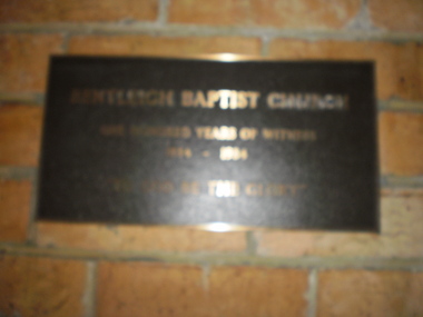 Glen Eira Historical Society
Document - Bentleigh Baptist Church Vickery Street Bentleigh
Reflections reprinted history extracts from Bentleigh Baptist Church Diary from September 1989 to March 1993. Issues includes a CD with digital photos Reflections reprinted history upon the centenary of Bentleigh Baptist Church 1984 by DL Audemard from May 1985 The Way We Were Feb 1990 pamphlet notes reflections on the churches ministery over the last 50 years by unknown author A brief printed history author unknown and undated on Bentleigh Baptist Church, 10 Vickery Street Bentleigh Two computer generated articles of correspondence between Claire Barton and Robert Bell on the gathering of Bentleigh & Korean Baptist Church history April 2010bentleigh, baptist church, brewer mr, tucker road, box henry, lush gp rev, east boundary, north road, bentleigh baptist church, brighton baptist church, tucker road church, box francis, box edith, clay jack, clay joy, lipman vern, lipman bronwyn, watt family, pioneers, watt richard, watt martha, market gardens, centre road, jasper road, watt herbert, horse drawn vehicles, stamp mr, hall annie, vickery street, watt may, clay family, marriott hector, watt don, watt family, box chris, lipman joy, grewar family, alexander chas, shephard f, chapman samuel rev, chambers h, eunson ta rev, boreham e rev, fletcher w rev, marriott hec – market gardens, kennedy jack, kennedy lil, kennedy isa mary, herron john, seawright celia, streckfuss edith, cole alice, grewar annie, grewar hall, faulkner ern, graham tom, cross mabel, cross w rev, trenches, grewar jean, ormond, wadley mr, wellum mr, hinton wh, rees gp rev, hinton mrs, wade ken rev, wadley mrs, bent st, wade mrs, bell powell, warner lawrence, architects, winckel l rev, richards jl, builders, streckfuss bert, marriott may, streckfuss family, sach florrie, sach family, reid mrs, reid lesley, mcmillan mrs, drapers, mckinnon road, streckfuss edith, simpson mrs, wellum mrs, leadlights, main mary, evans william john, cooke j, cooke mrs, cahill samuel george, smith kate, freeman nancy, wanless mrs, redmore ab, redmore mrs, audemard phil rev, hawkins margaret, ord elton, hawkins shiela, pith ron, bell mr, wallace pat, bell margaret, audemard joan, docker sandra, hubbard mark, thomas bernie, thomas mrs, lamprell mrs, herron mr, herron mrs, freeman mrs, beach mrs, paton john mrs, george lloyd, aspinal eric, bell gwen, sutton mrs, winkel mrs, neil mary, costain mrs, main mrs, baker mrs, cross mrs, kershaw mrs, smith millie, smith jack, freeman alf, harwood lindsay, harwood doreen, bell lesley, bell roberta, bentleigh korean baptist church, barton claire, hoare mike, hoare margaret, bott muriel, bridgeman pat, cook don, small hugh, trewin bill, smith eddie, iggulden sid, neve keith, horsford david, spencer wally, mcewan bill, holmes ron, holmes joyce, pullman peter, pullman elly, probbel peter, robinson john, bott laurie, main alice, disney clarrie, taylor kath, woff miss, rutledge peter, cameo playgroup, bentleigh baptist church, bentleigh, tucker road, foundation stones -
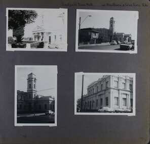 Glen Eira Historical Society
Album - Album page, Caulfield Town Hall cnr Hawthorn & Glen Eira Rds, Circa 1972
... spaces being the entry hall and staircase, main Hall, Foyer ...This photograph is part of the Caulfield Historical Album 1972. This album was created in approximately 1972 as part of a project by the Caulfield Historical Society to assist in identifying buildings worthy of preservation. The album is related to a Survey the Caulfield Historical Society developed in collaboration with the National Trust of Australia (Victoria) and Caulfield City Council to identify historic buildings within the City of Caulfield that warranted the protection of a National Trust Classification. Principal photographer thought to be Trevor Hart, member of Caulfield Historical Society. Most photographs were taken between 1966-1972 with a small number of photographs being older and from unknown sources. All photographs are black and white except where stated, with 386 photographs over 198 pages. Caulfield Town Hall is now known as Glen Eira Town Hall.From Victorian Heritage Database: Citation for Town Hall, Corner Glen Eira and Hawthorn Roads - HO106 https://vhd.heritagecouncil.vic.gov.au/places/43613 as at (19/10/2020) The former City of Caulfield (now City of Glen Eira) Municipal Offices, located at the south-west corner of Hawthorn and Glen Eira Roads, Caulfield South, were commenced for the Borough of Caulfield in 1884 when they also included a Post and Telegraph Office and Court of Petty Sessions. They were designed by the Borough surveyor, Sydney Smith. The hall was completed in 1890 to the design of Alexander Rankin and the present hall, foyer and portico completed to the design of Goldsmith and Jenkin, architects, in 1931. The complex is historically, aesthetically and socially significant. It is historically significant {Criterion A) as the centre of Local Government services in the area since 1885 and as a centre of post and telegraph and legal services for a period. Its association with architect and Borough surveyor, Sydney W. Smith is important in that the east elevation and facade (ground floor level only)as far west as the tower (lower two stages) survive as evidence of his work, the practice which his son continued after his death in 1886, becoming highly successful. The work of Goldsmith and Jenkin is historically important in that it indirectly demonstrates the growth of the City sustained during the Inter-war period, the work proceeding in spite of the Depression. It compares with other similar work of that time including the refurbishment of the Malvern Municipal Offices and Hall in 1927 (Hudson and Wardrop), the Melbourne Corporation Offices and Hall in 1925-28 (Stephenson and Meldrum, A. and K. Henderson) and the Camberwell Offices and Council Chamber in 1924 (Leighton Irwin and Roy Stevenson), other comparable municipal projects being undertaken during the 1930s. Finally, the Goldsmith and Jenkin works are important as a project of the Depression years organised specifically to alleviate unemployment problems in the Municipality. The complex is aesthetically important (Criterion E) as a prominent and imposing Classically derived complex of its type with individually noteworthy interior spaces being the entry hall and staircase, main Hall, Foyer and Council Chamber. The Adamesque plasterwork, timber panelling and furniture, Art Nouveaux enrichment and Classically derived treatment with sparing use of Australian decorative motifs are contributory elements. Exterior .elements of note include the remains of the original design prepared by Sydney Smith and the clock tower and portico which have come to symbolise important Municipal complexes erected prior to the Second World War. The complex is socially important (Criterion G) for the value placed on it by the community which has made use of it for activities including that of Local government for well over a century.Page 74 of Photograph Album with four photographs (three portrait and one landscape) of different views of the Caulfield Town Hall.Hand written: Caulfield Town Hall cnr Hawthorn & Glen Eira Rds [top right] / 74 [bottom right] trevor hart, caulfield, glen eira, caulfield town hall, sydney smith, sydney w smith, municipal, adamesque plasterwork, adamesque, art nouveaux, portico, council chambers, alexander rankin, foyer, local government, timber panelling, tower, unemployment, clock tower, hawthorn road, glen eira road, city of glen eira, municipal offices, post and telegraph office, goldsmith and jenkin, courthouses, surveyors, architects, classical architectural style, streetscapes, gardens, cars, glen eira town hall, depression 1929-1939 -
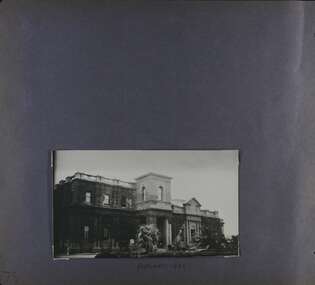 Glen Eira Historical Society
Album - Album page, Caulfield Town Hall cnr Hawthorn & Glen Eira Rds, Circa 1972
... spaces being the entry hall and staircase, main Hall, Foyer ...This photograph is part of the Caulfield Historical Album 1972 but is noted as taken in 1922. This album was created in approximately 1972 as part of a project by the Caulfield Historical Society to assist in identifying buildings worthy of preservation. The album is related to a Survey the Caulfield Historical Society developed in collaboration with the National Trust of Australia (Victoria) and Caulfield City Council to identify historic buildings within the City of Caulfield that warranted the protection of a National Trust Classification. Principal photographer thought to be Trevor Hart, member of Caulfield Historical Society. Most photographs were taken between 1966-1972 with a small number of photographs being older and from unknown sources. All photographs are black and white except where stated, with 386 photographs over 198 pages. Caulfield Town Hall is now known as Glen Eira Town Hall.From Victorian Heritage Database: Citation for Town Hall, Corner Glen Eira and Hawthorn Roads - HO106 https://vhd.heritagecouncil.vic.gov.au/places/43613 as at (19/10/2020) The former City of Caulfield (now City of Glen Eira) Municipal Offices, located at the south-west corner of Hawthorn and Glen Eira Roads, Caulfield South, were commenced for the Borough of Caulfield in 1884 when they also included a Post and Telegraph Office and Court of Petty Sessions. They were designed by the Borough surveyor, Sydney Smith. The hall was completed in 1890 to the design of Alexander Rankin and the present hall, foyer and portico completed to the design of Goldsmith and Jenkin, architects, in 1931. The complex is historically, aesthetically and socially significant. It is historically significant {Criterion A) as the centre of Local Government services in the area since 1885 and as a centre of post and telegraph and legal services for a period. Its association with architect and Borough surveyor, Sydney W. Smith is important in that the east elevation and facade (ground floor level only)as far west as the tower (lower two stages) survive as evidence of his work, the practice which his son continued after his death in 1886, becoming highly successful. The work of Goldsmith and Jenkin is historically important in that it indirectly demonstrates the growth of the City sustained during the Inter-war period, the work proceeding in spite of the Depression. It compares with other similar work of that time including the refurbishment of the Malvern Municipal Offices and Hall in 1927 (Hudson and Wardrop), the Melbourne Corporation Offices and Hall in 1925-28 (Stephenson and Meldrum, A. and K. Henderson) and the Camberwell Offices and Council Chamber in 1924 (Leighton Irwin and Roy Stevenson), other comparable municipal projects being undertaken during the 1930s. Finally, the Goldsmith and Jenkin works are important as a project of the Depression years organised specifically to alleviate unemployment problems in the Municipality. The complex is aesthetically important (Criterion E) as a prominent and imposing Classically derived complex of its type with individually noteworthy interior spaces being the entry hall and staircase, main Hall, Foyer and Council Chamber. The Adamesque plasterwork, timber panelling and furniture, Art Nouveaux enrichment and Classically derived treatment with sparing use of Australian decorative motifs are contributory elements. Exterior .elements of note include the remains of the original design prepared by Sydney Smith and the clock tower and portico which have come to symbolise important Municipal complexes erected prior to the Second World War. The complex is socially important (Criterion G) for the value placed on it by the community which has made use of it for activities including that of Local government for well over a century.Page 75 of Photograph Album with one portrait photograph of the exterior of Caulfield Town Hall taken in 1922.Hand written: FEBRUARY 1922 [under photo] / 75 [bottom left] trevor hart, caulfield, glen eira, caulfield town hall, sydney smith, sydney w smith, adamesque plasterwork, art nouveaux, portico, council chambers, alexander rankin, foyer, local government, timber panelling, tower, unemployment, clock tower, hawthorn road, glen eira road, city of glen eira, municipal offices, palms, gardens, post and telegraph offices, goldsmith and jenkin, architects, city of caulfield, ivy clad walls, surveyors, depression 1929-1939, glen eira town hall