Showing 10966 items
matching maps
-
 Eltham District Historical Society Inc
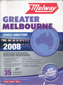
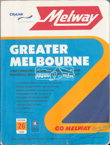
Book, Melway Greater Melbourne street directory 2008 : including Geelong, Phillip Island, Healesville, Kinglake, Gisborne, Lorne, Bacchus March, Wallan, Bellarine & Mornington Peninsulas; Edition 35, 2008, 2007
Edition 35. 2008 Coloured detailed maps accessed by a street or location index. Cover: Totally revised and updated with over 730 additional street listings, new maps extending the Gisbourne and Wallan areas. The most comprehensive public transport routes information - train, tram, bus, walking and bicycle tracks. Eastlink fully detailed, Victoria Racing Club, Flemington enlargement, GPS compatible WGS/MGA Grid displayed, This editon is available in LARGE PRINT format, new eway electronic street directory now available - www.melway.com.au Special feature: New Hierachy of Roads Street directory, coloured maps, indexes, 1201 pagesstreets,roads,melbourne,map,melway -
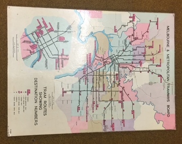 Melbourne Tram Museum
Map, Melbourne & Metropolitan Tramways Board, Del J. Chau, "Tram Routes showing destination numbers", 1972
Titled "Tram Routes showing destination numbers". Map dated 1972, showing routes with route numbers, including short working, names of main destinations, roads, railway stations and rail lines, municipalities, rivers, scales, city section in detail, depots and Sunday only services. In bottom right hand corner has number P.14431, Del J. Chau 1972. The original has been altered to show the Bundoora, La Trobe University and East Burwood lines and the change to Airport West. Type of map that was placed on the rear of the driver's doors of a W Class tramcar.Demonstrates a MMTB produced map used in trramcars.Full colour map or poster printed on heavy cardboard.trams, tramways, mmtb, map, routes -
 Lakes Entrance Regional Historical Society (operating as Lakes Entrance History Centre & Museum)
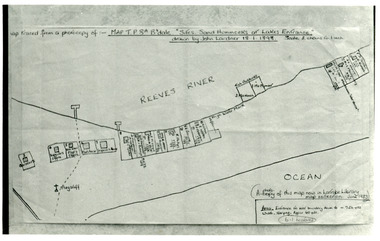
Photograph, 1898
Map traced from a photocopy of :- Map TP8A Bairnsdale. 'Site. Sand Hummocks of Lakes Entrance'. Drawn by John Lardner 18 January 1898. Scale two chains to one inch. ( A photocopy of this map in Latrobe Library map collection, June 1983)Black and white photograph showing sketch map of 1898 by John Lardner Plan of Sites - sand hummocks. Drawing shows sites of buildings at entrance along Cunninghame Arm shoreline at Lakes Entrance, Victoria.islands, waterfront, boats and boating, township -
 City of Kingston
Pamphlet - Colour, Moorabbin News Print, Auction = Sale Heather Grove Estate, c. 1914
Sales plan for land in the suburb of Cheltenham, bounded by Tulip Grove and Heather Grove.The developing urban area of Highett within the City of Kingston. This land sale pamphlet illustrates the subdivision of land within the municipality and the changing demographic of the district as new houses are constructed close to infrastructure.Colour pamphlet advertising auction of Heather Grove Estate, Cheltenham. Incorporates a map of the estate bordered by Wickham Road, Railway Parade, Highett Road and Point Nepean Road.Handwritten in grey pencil on subdivision 1: Sold / 20/- Handwritten in grey pencil on subdivision 2: 25/- Handwritten in grey pencil on subdivision 3: 30/- Handwritten in grey pencil on subdivision 4: 110 / 30/- Handwritten in grey pencil on subdivisions 1, 11, 10, 9 and 8: Sold Handwritten in grey pencil beneath 'Heather Grove': 20/- 20/- 20/- 20/- Handwritten in black ink on subdivison 12 and 7: £85 Handwritten in back ink on subdivision 5: £60 Handwritten in back ink on subdivision 6: £65 Handwritten in grey pencil above subdivision map: 1-8-9-10-11 Handwritten in grey pencil above subdivision map: [enclosed in a circle] 12- / £75 Handwritten in grey pencil above subdivision map: [enclosed in a circle] 2 / £85 Handwritten in grey pencil above subdivision map: [enclosed in a circle] 3 / £100 Handwritten in grey pencil above subdivision map: [enclosed in a circle] 4 / £100 Handwritten in grey pencil above subdivision map: [enclosed in a circle] 5 / £60 Handwritten in grey pencil above subdivision map: [enclosed in a circle] 6 / £65 Handwritten in grey pencil above subdivision map: [enclosed in a circle] 7 / £25- Handwritten in grey pencil above subdivision map: [enclosed in a circle] £125 / [indecipherable] Handwritten in grey pencil above subdivision map: 37.00 / 18.10 / 56.80 / 3 / [horizontal line] / 59 8 Handwritten in grey pencil along railway line marking: 21/6 / 12/6 / 13/- / 19/-land sales, estate, cheltenham -
 Eltham District Historical Society Inc
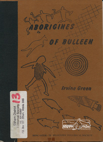
Book, Irvine Green, Aborigines of Bulleen : the history of the Aborigines of the Wurundjeri tribe who inhabited the area which became the city of Doncaster and Templestowe / Irvine Green, 1989
Wurundjeri territorial groupings; subsistence; recreation of daily life; recreation; tribal law; kinship; childhood; religion and mythology; material culture, includes description of bark canoe manufacture; map of significant sites; culture contact and historyPaperback; 40 p. : ill., maps ; 23 cm.ISBN 0947353003aborigines, wurundjeri, social customs, stories, bulleen -
 Peterborough History Group
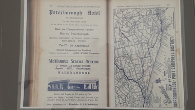
Book - Broadbents Map Warrnambool - Port Campbell district
Advertisement for the significant local building of the time for the Peterborough Hotel. Also contains detailed map of the local roads.The Peterborough Hotel was a significant local building until it burned down in the 1960's.A4 copy of a Broadbent Map which includes an advertisement for the Peterborough Hotel. Approx 1950-1960.peterborough hotel, broadbents guide, peterborough hotel advertisment, john wiber, james irvine -
 Bendigo Military Museum
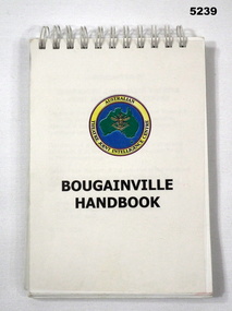
Booklet - NOTEBOOK FOR THE MEMBERS PEACE MONITORING GROUP BOUGANVILLE, Australian Theatre Joint Intelligence Centre, BOUGANVILLE HANDBOOK, 1999
... Maps ...Conflict Period 1990-1999. PNG Bougainville (TMG) 1997-1998 PNG 1998-2003.Spiral bound pages. Clear plastic covering, white cardboard cover with map of Australia in green, blue background with a yellow round border with black printed words. Booklet has 79 pages. 1-50 black printed wording. 51-79 Photographs of equipment, books, people. Back of booklet has 3 folder maps in various colours.Front cover "AUSTRALIAN THEATRE JOINT INTELLIGENCE CENTRE" BOUGAINVILLE HANDBOOK Back cover - Printed November 1999maps, peace monitoring, manual, books -
 Whitehorse Historical Society Inc.
Map, Ringwood, c1922
... Maps ...Victoria Ringwood Survey map 1 inch to 1 mile.Victoria Ringwood Survey map 1 inch to 1 mile. Covers Eastern suburbs of Melbourne from Richmond to Macclesfield, Heidelberg / Lilydale to Dandenong. Prepared by Commonwealth Section, Imperial General Staff.Victoria Ringwood Survey map 1 inch to 1 mile. eastern suburbs, melbourne, maps -
 Greensborough Historical Society
Document, Parliament of Victoria, Ministers & Members search - the Hon. Colin Brooks (Bundoora), 23/04/2021
Biographical details of the Hon. Colin Brooks, MLA for Bundoora, taken from Parliament of Victoria - Ministers and Members website; and, map of the electoral district of Bundoora.2 p. text and colour photograph, with colour map of Bundoora Electoral Districtbrooks family, victoria parliament, colin brooks, bundoora -
 Wangaratta RSL Sub Branch
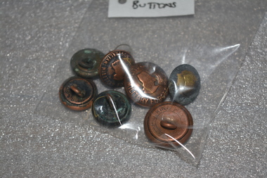
Buttons - Australian Military Forces
Five small and three large buttons. Are a brass colour with Australian Military Forces written around the outside, a map of Australia in the middle with a crown on top.On front: Australian Military Forces. Also has the map of Australia with a crown on top, On back: P.J.King Pty Ltd, Melb. australian army, australia military badges, buttons, australian buttons, australian military forces buttons -
 Greensborough Historical Society
Map, Melbourne and Metropolitan Board of Works. Survey Division, MMBW, Yarra 2500 / 12.23. Janefield and Kangaroo Point, 1977_10
Melbourne and Metropolitan Board of Works. Yarra 2500 [base map] 12-23, Municipalities of Whittlesea 239 and Diamond Valley 257. No streets marked on this map. Includes Plenty River, Kangaroo Point, Janefield Colony and Janefield Reserve.MMBW Map in 1:2500 [scale] series. Cream parchment with green tape reinforcing on edges and punched holes on left edge.mmbw, melbourne and metropolitan board of works, shire of diamond valley, plenty - maps -
 Cheese World Museum
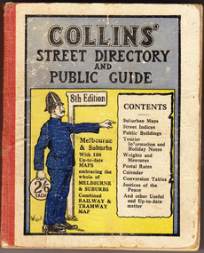
Book, Queen City Printers Pty Ltd, Collins Street Directoryand Publice Guide: 8th Edition
... maps ...The Percy Uebergang family lived at Tooram Park, Allansford from 1912 until 1992. This booklet was part of the collection of items given into the care of the Cheese World Museum. Uebergang catalogue No. -not listed White hard cover pocket-sized street directory book with red cloth spine. The front cover has a blue and yellow background with title, contents, edition listed and a policeman in a blue uniform. The back cover has information in black print. Melbourne and suburbs maps throughout. 439 pages.COLLINS' STREET DIRECTORY/AND/PUBLIC GUIDE/8th Edition/2/6 each/CONTENTS/ Suburban Maps/Street Indices/Public Buildings/Tourist Information and Holiday Notes/Weights and Measures/Postal Rates/Calendar/Conversion Tables/Justices of the Peace/And other useful and up-to-date matterallansford, uebergang, street directory, public guide, collins, melbourne, maps, tourist information, queen city printers pty ltd, almanacs, local history -
 Dutch Australian Heritage Centre Victoria
Road Map, Nederland
Cleverly folded 1:250,000 road map produced in Dutch, French, German and English containing not only the Dutch road network but also much information of interest to tourists. It is enclosed in a brown imitation leather cover that closes with a stud. Optimal ease of use through patented Falk folding mode.Falk Plan. Road Map. Netherlands. Repeated in Dutch, French and German. -
 Anglesea and District Historical Society
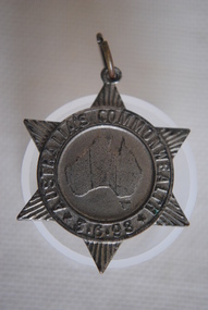
Medal Commemorative Australian Federation, 1898
Ref/ Car. 1898/2. Star shapped medal issued in 1898 tocommemorate the forthcoming Commonweath of Australia - a map of Australia in the centre divided into six states/colonies, each state represented by a ray - inscribed around the circumferance and with provision for a pin to be attached with hole and metal ring on the top ray of star. Back of medal perfectly plain.Map of Australia within ring. Around ring: "AUSTRALIA'S COMMONWEALTH" *3.6.98*medal, commemorative, australian federation -
Whitehorse Historical Society Inc.
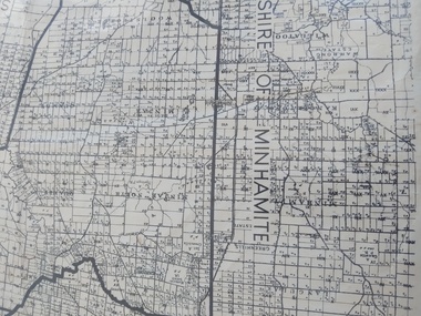
Map, Map 1892. Nunawading Shire, 1892
... Maps ...Duplicated same as ND5060 Map of Shire of Nunawading.Duplicated same as ND5060 Map of Shire of Nunawading. Shows railway line including spur from Box Hill to Box Hill Brick Co.Duplicated same as ND5060 Map of Shire of Nunawading. maps, shire of nunawading, railways, box hill brick company -
![The Scientific Savant in Nineteenth Century Australia / [by] Australian Academy of Science](/media/collectors/550653872162f11fb04854aa/items/5ed043e1dcf9cd08346b7493/item-media/5ed04634dcf9cd08346b840c/item-fit-380x285.jpg) Kew Historical Society Inc
Kew Historical Society IncBook, Historical Records of Australian Science, The Scientific Savant in Nineteenth Century Australia, 1997
Scientific savant in nineteenth century Australia. 1996 commemorative conferences, Royal Botanic Gardens, Melbourne, Sunday 29th September to Saturday 5th October 1996 held at the University of Melbourne, the scientific savant in 19th century Australia, celebration of the life, times and legacy of Ferdinand von Mueller, program & abstracts23 pages : map ; 30 cm.non-fictionScientific savant in nineteenth century Australia. 1996 commemorative conferences, Royal Botanic Gardens, Melbourne, Sunday 29th September to Saturday 5th October 1996 held at the University of Melbourne, the scientific savant in 19th century Australia, celebration of the life, times and legacy of Ferdinand von Mueller, program & abstractsroyal botanic gardens - melbourne (vic.), ferdinand von mueller -
 Stawell Historical Society Inc
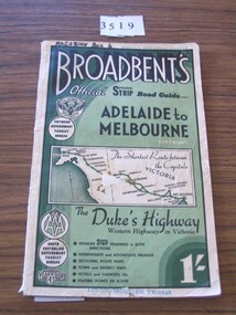
Book, Broadbent directory, Broadbent's Official : Speedo Strip Road Guide, 1943
Maps and descriptions of towns on the Western Highway & Dukes Highway from Melbourne to Adelaide. Sponsored by R.A.C.V and The Victorian Government Tourist BureauCream paper cover back border with green filling with a map from Melbourne to AdelaideBroadbeants Official Speedo Strip guide Melbourne to Adelaidestawell transport -
 Melbourne Tram Museum
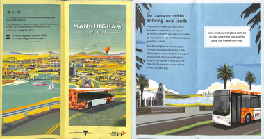
Map, Transport for Victoria, "Manningham Transport Map", c2018
... Maps ...Pamphlet - 12 fold DL - colour titled "Manningham by Bus" or "Manningham Transport Map", giving a detailed bus and tram map for the City of Manningham, cantered around the Doncaster Shopping centre. Covers route 109 and 48. Published by "Transport for Victoria" c2018 - no publication date. The tram portion of the map has been imaged. At the time of entry, the given website "melbournebybus.com.au" went to the PTV website.trams, tramways, maps, manningham, route 48, route 109 -
 Eltham District Historical Society Inc
Book, Melway Greater Melbourne street directory : including Geelong, Phillip Island, Healesville, Bellarine & Mornington Peninsulas; Edition 26, 1999, 1999
... maps ...Street directory with plastic cover, coloured maps, 772 pages 28 cm x 21.5 cm 1998streets, roads, melbourne, maps, melway -
 Lorne Historical Society
Map, F W Niven Lithos, The Mountjoy Lorne Estate, 1889
In 1888 a company was formed to acquire and subdivide the land of the Mountjoy Brothers. The land totaled 197 acres and included Erskine House. The land colored red was that of the Mountjoys. The subdivision map was printed in 1889A paper map of the Mountjoy Estate Lorne , showing allotments, with their owners, and naming land use. It has four black and white line drawings , Erskine House, Mountain View’s, the Rapids, Erskine House sea view and Erskine Falls. The map is largely black and white with red and blue colouring. The map is mstuck to brown paper. lorne, subdivision map, erskine house, mountjoy brothers, -
Tatura Irrigation & Wartime Camps Museum
Box of Maps, early 20th century
Maps are of the following: Toolamba (2), Toolamba West (2), Undera (2), North Murchison, Coomboona (2), Mooroopna, Waranga, Kyabram East, Girgarree East, Mooroopna West (2), Tatura and Goulburn irrigation district (pre 1956).Box containing maps of individual parishes in the county of Rodney, showing early selections. Also one of early Tatura townships with owners of many house blocks. 17 maps.each one is labelled with the parish (Toolamba, Tatura, , etc.) -
Clunes Museum
Map - MAP OF TOURELLO LAND HOLDINGS
THERE ARE NO NAMES, NO DATES. IT SEEMS TO BE CUT OFF A BIGGER MAPTWO COPIES OF AN EARLY MAP OF TOURELLO LAND HOLDINGS ONE COPY IS COPIED ON A 4 PAPER AND STUCK TOGETHER WITH STICKY TAPEtourello land holdings, tourello map -
 Peterborough History Group
Map - Shire of Warrnambool
Map of the area, when Peterborough was part of Warrnambool ShireHistoric map of the area when Peterborough was in the Warrnambool ShireA3 size map, larger view of the whole shire of Warrnambool, and includes adjoining Shire Boundaries. Shows individual land allotments.peterborough, warrnambool shire, old maps -
 National Wool Museum
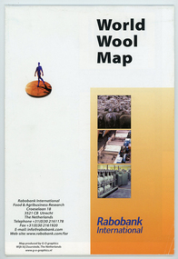
Map - World Wool Map, Rabobank International, c.2002
Part of a collection of books, manuals, photographs, letters and clothing relating to the working life of Stuart Ascough. Stuart's career in the wool industry spanned over 43 years from 1960 to 2003 in various roles including Topmaking Plant Manager at Courtaulds Ltd. in Spennymore, U.K., Operations Manager at Port Phillip Mills in Williamstown Victoria, Marketing Executive, Early Stage Wool Processing at the International Wool Secretariat Melbourne, Australia and General Manager of Victoria Wool Processors Pty. Ltd. in Laverton North, Victoria. Throughout his career Stuart travelled extensively, and in the 1990s worked at many topmaking mills in China on quality improvement projects. He also provided technical advice and training at mills in India, Ukraine, Lithuania, Kyrgyzstan, Russia, Latvia, Byelorussia and other parts of Europe and Asia.Folded world map showing statistics, images and graphics relating to wool in the 1990's.front: World Wool Map / Rabobank / International / Rabobank International / Food & Agricultural Research / Croeselaan 18 / 3521 CB Utrecht / The Netherlands / Telephone +31 (0) 30 2161178 / Fax +31 (0) 30 2161920 / E-mail: [email protected] / Web-site:www.rabobank.com/far / Map produced by G-O graphics / Wijk bij Duurstede, The Netherlands / www.g-o-graphics.nlstuart ascough, international wool secretariat, victoria wool processors, port phillip mills pty ltd, topmaking, career, wool industry, training, technical advice, mills, map -
 8th/13th Victorian Mounted Rifles Regimental Collection
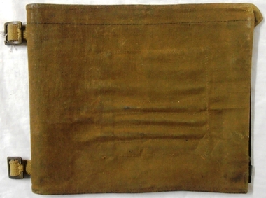
Functional object - Map case, 1942
Fine example of officer's accessory to hold map securely and protected from weather.Fine example of officer's accessorily to hold map securely and protected from weather.Hard fibre board panel with metal clips securing clear Perspex sheet covering map; canvas flap attached to one edge of board folding over and secured to other side of board with two metal press studs. Underside of flap has pockets for chinagraph marking pencils. Map is RACV road map of area southwest of Eildon Victoria probably a training area for 13th Motor Regiment. Also has two buckles to allow attachment to user's webbing.Stamped on cover flap "CG Hartley & Co 1942"map, motor, 13th, gippsland -
 Ballarat RSL Sub-Branch Inc.
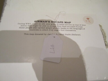
Cloth Map - Airman's Escape Map France, Belgium & Holland
... Maps ...During WWII, maps on silk were given to allied aircrew so that (if shot down) they might be able to escape from Nazi-occupied Europe. Some people also carried simple phrase books in the languages of countries in which they might find themaps, ballarat rsl, ballarat -
 Melbourne Tram Museum
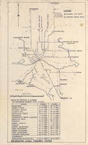
Map, Melbourne cable tram system, 1971?
Map showing the Melbourne cable tram system, with a list of opening and closing dates for the various lines, opened by the Melbourne Tramways Trust. Shows engine houses and car houses (or depots), location names, railways, and a scale. Includes notes on other dates tracks were changed and the Northcote to Clifton Hill line. No marks as to who prepared the map.Yields information about the Melbourne Cable Tram system.Foolscap sheet - Map - Melbourne cable tram system showing tracks, car houses and engine houses.Has a date stamp 22 Apr 1971 in bottom right hand corner.tramways, cable trams, trams, map, melbourne tramways trust, mtt, engine houses, depots, car houses -
 Greensborough Historical Society
Map, Municipality of Heidelberg Plan No. 481, 23/9/1949
Central area of Greensborough, South boundary Grimshaw Street, showing river and buildings in green and gradients in red. Adjoins Map No. 480 to West.Black & white map with features in red and green. Scale: 160 feet to 1 inch.greensborough, grimshaw street greensborough -
Whitehorse Historical Society Inc.
Pamphlet, Antonio Park, 1980?
Antonio Park: a valuable remnant of natural bush :Antonio Park: a valuable remnant of natural bush : leaflet for visitors including map and notes on the park's history, flora and fauna.Antonio Park: a valuable remnant of natural bush :antonio park, mitcham -
Whitehorse Historical Society Inc.
Map, Melbourne Geological Map, 1937
... Maps ...Geological Map of Melbourne & Suburbs.Geological Map of Melbourne & Suburbs. Scale: 40 chains to 1 inch with inset 10 miles to 1 inch. Includes Municipal and Parish boundaries, railways and stations, electric tramways, cable tramways, Post Offices and State schools. Area bounded by Braybrook, Preston, Blackburn & Brighton. Printed on linen.Geological Map of Melbourne & Suburbs. melbourne, maps