Showing 8403 items matching "mckillops-bridge"
-
 Orbost & District Historical Society
black and white photographs, Howard D. Bulmer, first half 20th century
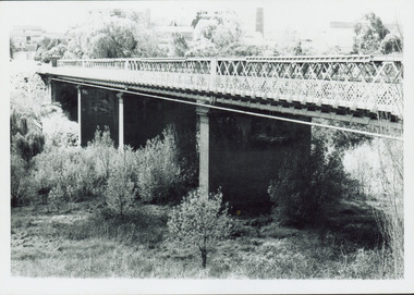
This bridge was built in the 1920s as a road and rail bridge, and was partly washed away by flood waters in 1934. After the end of the first World War the Victorian Railways considered an extension of the railhead across the river at Orbost, and in 1922 a new timber and steel girder structure, a joint Country Roads Board — Victorian Railways venture, was built and completed at a cost of £41,000 (the steel girders came from the Flinders Street viaduct reconstruction). Subsequently it was decided not to take the railway across the river, and the bridge has only been used by road traffic. This is a pictorial record of an early bridge across the Snowy River at Orbost.A large black / white photograph of the Orbost Snowy River bridge. There is a large copy as well as a postcard copy in sepia.on front - Snowy River Bridge Orbost H.D. Bulmer - photo - Lake Tyers.snowy-river-bridge-orbost -
 Eltham District Historical Society Inc
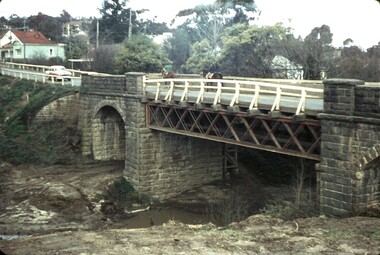
Slide - Photograph, Bridge Street Bridge, Eltham, c.Sep. 1989
Part of a slide show presentation "Bridges & Waterways of the Shire" by Russell Yeoman to the 13 September 1989 Society meeting. The presentation included slides of historic photos from the Shire of Eltham Pioneers collections as well as several recent views.35mm colour positive transparency (1 of 33) Mount - Agfa CS System grey 8 dotsProcess Date Sep 1989bridge street bridge, eltham -
 Ringwood and District Historical Society
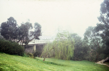
Photograph, Warrandyte Rd. Bridge, Ringwood. 1978
Written on back of photograph, "Warrandyte Rd. Bridge". Catalogue card dates photograph, "1/5/78" -
 Ringwood and District Historical Society
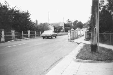
Photograph, Warrandyte Rd. Bridge over Mullum Creek, Ringwood, showing stumps of old piles (undated)
Poor quality, blurry photographWritten on back of photograph, "Warrandyte Rd. Bridge over Mullum Creek showing stumps of old piles". -
 Ringwood and District Historical Society
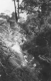
Photograph, Mullum Creek, 75 yds east of Warrandyte Rd. Bridge 1964
Possibly May 1971 as per item 2979?Typed below photograph, "Mullum Creek, 75 yds east of Warrandyte Rd. Bridge in centre". 1964 -
 Ringwood and District Historical Society
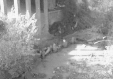
Photograph, Earth fill over culverts in place of old Warrandyte Road bridge, Ringwood 1986
Written on back of photograph, "29.22.86. Earth fill over culverts in place of old Warrandyte Road bridge." -
 Ringwood and District Historical Society
Photograph, Mullum Mullum Creek. West side of Warrandyte Road Bridge. Ringwood 1986
Written on back of photograph, "3.8.86. Ringwood. Mullum Mullum Creek. West side of Warrandyte Road Bridge." -
 Southern Sherbrooke Historical Society Inc.
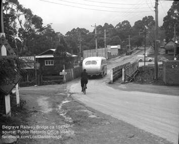
Photograph, Belgrave Railway Bridge, 1947
Belgrave railway bridge looking towards Bayview Road from Terrys Ave, 1947. It shows a bus crossing the bridge onto (now) Belgrave-Gembrook Road, followed by a male cyclist wearing a dark overcoat and bowler hat. A man wearing a homburg hat is crossing the footbridge beside the main bridge towards the main street. There is a pale van parked (or driving past) a dairy on the corner of Bayview Rd and Belgrave-Gembrook Road. A brick toilet block is shown with a sign saying 'MEN' on a nearby lamp post. -
 Ballarat Tramway Museum
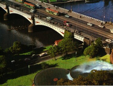
Postcard, Murfett Pty Ltd, Princes Bridge Melbourne, c1968
Colour postcard of Princes Bridge and South Gate Fountain Melbourne, late 1960's. Postcard shows the southern end of the Princes Bridge, has 3 W2's on bridge, each with marker lights and the South Gate fountains, existing at the time of the photograph. Since replaced by the Arts Centre. On rear is printed caption, giving details of the location, the date of the fountain construction (1959), stamp placement area and publishers details and post card number (8P 1053-2), National View by Murfett Publishers.On top edge near stamp area in black ink "1968".trams, tramways, melbourne, southgate, princes bridge, mmtb -
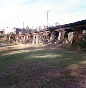
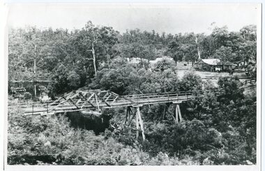 Orbost & District Historical Society
black and white photograph, c1920-1954
This is a copy of "THE BRIDGE AT BOGGY CREEK, NOWA NOWA, LAKE TYERS." which is a Rose Stereograph Co postcard. Boggy Creek Bridge was built in 1916 as part of the Bairnsdale to Orbost extension to the main Gippsland Railway, and is situated in the middle of the township of Nowa Nowa, crossing a steep-sided and well-timbered creek-valley. This section of the line closed in 1987. This bridge plays a major part in the identity and history of the town of Nowa Nowa, This item is associated with the East Gippsland Railway.A large black / white photograph of a large wooden bridge across a creek. There is a house and outbuildings in the background on the right. It is in a bush setting. on back - "Boggy Creek bridge - Nowa Nowa 1887 LaTrobe Collection"boggy-creek-bridge east-gippsland-railway -
 Stawell Historical Society Inc
Photograph, Three bridges at Campbells bridge c1960 -- Coloured
Coloured photo of three bridges at Campbells bridge c1960stawell shire -
 Eltham District Historical Society Inc
Photograph, George W. Bell, Looking towards trestle bridge from new Shire Hall, 1965c
Black and white photograph looking west to railway bridge over Diamond Creek from Shire Office carpark c.1965.bridges, railways, eltham, diamond creek, eltham shire office, george w bell collection -
 Eltham District Historical Society Inc
Photograph, Watsons Creek Bridge, 1970c
Black and white photograph of Yarra Glen Road Bridge over Watsons Creek at Watsons Creek (Kangaroo Ground) c.1970bridges, watsons creek, kangaroo ground, yarra glen road, eltham yarra glen road -
 Ringwood and District Historical Society
Photographs, Train riding on the buffer at the rail bridge above Wantirna Road, Ringwood - 8-Dec-1992, 8-Dec-92
Photographs (2) taken at the Ringwood Wantirna Road rail bridge of train riding on the buffer. Date of incident on 8-Dec-1992. -
 Ringwood and District Historical Society
Photograph-B&W, Joan Walker, East Ringwood 2000-Eastfield Road Bridge looking West To East Ringwood, 2000
East Ringwood 2000-Eastfield Road Bridge looking West To East Ringwood- B&W Photo from Album 6501 -
 Nillumbik Shire Council
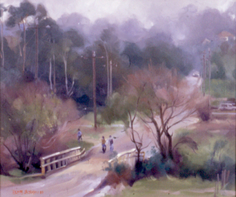
Painting: Hilary JACKMAN (b.1943 Melb AUS), Brougham Street Bridge, 1980
Oil on canvas board. Landscape painting of Eltham with Brougham Street bridge in the foreground. People walking down the road and cars in the backgroundLower left, red paint 'HILARY JACKMAN 80'landscape, painting, eltham, bush, bridge, brougham street, jackman -
 Whitehorse Historical Society Inc.
Article, Cross Over Bridge, 2016
Community opinions on the Deakin University proposed bridge over Gardiners Creek Reserve.Community opinions on the Deakin University proposed bridge over Gardiners Creek Reserve that will link the two halves of its Burwood campus.Community opinions on the Deakin University proposed bridge over Gardiners Creek Reserve.deakin university, gardiners creek reserve, burke, anna, wynne, richard -
 Kew Historical Society Inc
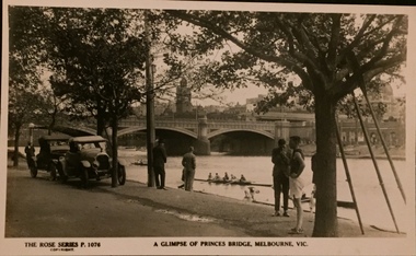
Postcard, Rose Stereograph Company, A Glimpse of Princes Bridge, Melbourne
One of a number of 'real photo' and commercial postcards created by or owned by members of the Christian and Washfold families of Kew. The postcards are part of a larger collection of photographs, postcards and publications donated to the collection in May 2021.Monochrome postcard of Yarra at Princes Bridge with rowers on river and cars, bystanders and an athlete in foreground. Three oars lean against tree. The Rose Series P. 1076postcards -- melbourne, princes bridge -- melbourne, postcards - the rose series, christian-washfold collection -
 Falls Creek Historical Society
Photograph - Building Bridge at High Plains Road, Falls Creek 1950
These photos are part of the Fred Griffith Collection. Frederick Charles “Fred” Griffith was born in Albury, NSW on 2 March 1910. Educated in Albury and Geelong Grammar. Beginning in 1927 he spent many years working first as a jackeroo and on a range of prominent pastoral and merino stud properties in NSW and Queensland. In 1935 he repurchased his former family property “Toonallook", Bowna, NSW and developed it to be the largest Romney Marsh stud in the world, exporting rams to Argentina. He introduced many innovative practices on his property including rabbit control measures and aerial crop dusting. He was an active member of the Albury Show Society and in 1949 established the Albury Sheep Show. Fred was also the Albury representative on the Graziers’ Association Council for over 30 years. He became a life member of both the Albury and Commercial Clubs. Fred’s greatest hobby was snow skiing. His first visit to the snow was to Kosciusko in 1919. The Albury Ski Club was formed in 1935 and Fred was an inaugural member. In 1949 they were granted a site at Falls Creek to build their own lodge. Fred guaranteed the Club for finance from the Bank of NSW. The first portion of the prefabricated building was constructed in Albury. It was transported to Falls Creek on the back of Fred’s truck and erected in one day. This was the bathroom section and the rest was completed in 1950. The original lodge was burned down in 1952 and a new one built the following year. In 1955, Fred also built the Bowna Lodge for his family in partnership with David Fairbairn. He became head of the North Eastern District Skiing Association (N.E.D.S.A.) and successfully applied to run the Australian Ski Championships. Fred also inaugurated children’s races at Falls Creek and ran them for about 20 years. He also formed the company “Falls Creek Ski Tows”. In 1956 Fred along with a group of key people selected the site for Thredbo Village. Fred and his brother sold Toonallook in sections between 1951 and 1974. He moved to Albury and set up as a landscape gardener and fencing contractor. After a serious work accident, Fred retired in 1985 and moved to Rosebud, Victoria where he died on 19 August 1992.These images record construction of a bridge at High Plains Road, Falls Creek Falls Creek by volunteers in 1950A set of black and white photographs showing steps in the construction of a bridge at Falls Creek on the King's Birthday weekend 05/06/1950fred griffith, falls creek, bridge building -
 Kew Historical Society Inc
Photograph - Outer Circle Railway Viaduct
The heritage listed Fairfield Bridge was originally constructed for the Outer Circle Railway to bridge the Yarra River between East Kew and Fairfield stations. In the 1930s it was converted for vehicular traffic. In the 2010s a new concrete bridge was erected beside it to increase vehicular capacity.Print copy, enlarged from original snapshot, of the former railway viaduct crossing the Yarra and linking Kew and Fairfield. The original photo predates the conversion of the viaduct into the Chandler Highway Bridge in the 1930s, when the Bridge was adapted to carry vehicular traffic. The date on the reverse indicates the date of donation rather than the date on which the photograph was taken. CHANDLER HIGHWAY BRIDGE OVER RIVER / (ORIGINALLY PART OF OUTER CURCLE RAILWAY) / OCTOBER 1977railway viaduct -- kew (vic.), fairfield bridge, fairfield railway viaduct, outer circle railway, sir john monash -
 Eltham District Historical Society Inc
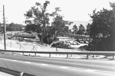
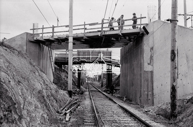
Negative - Photograph, Russell Yeoman, New road bridge under construction over railway line at junction of Sherbourne and Para Roads, Briar Hill, 1971
New bridge in foreground. Old bridge in background before demolition. This photo forms part of a collection of photographs gathered by the Shire of Eltham for their centenary project book,"Pioneers and Painters: 100 years of the Shire of Eltham" by Alan Marshall (1971). The collection of over 500 images is held in partnership between Eltham District Historical Society and Yarra Plenty Regional Library (Eltham Library) and is now formally known as the 'The Shire of Eltham Pioneers Photograph Collection.' It is significant in being the first community sourced collection representing the places and people of the Shire's first one hundred years.Digital image 35 mm B&W negativesepp, shire of eltham pioneers photograph collection, montmorency, briar hill, bridge, para road, railway bridge, railway line, road construction, sherbourne road, bridge construction -
 Marysville & District Historical Society
Photograph (Item) - Colour photograph, 1992
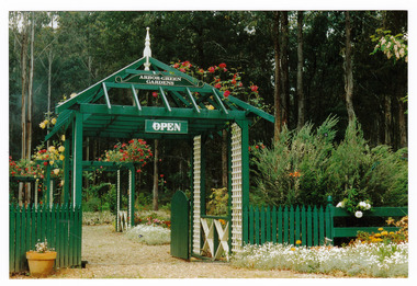
A colour photograph of the garden entrance and bridge at Arbor Green Gardens in Marysville. This cottage, along with most of the buildings in the township, was destroyed in the 2009 Black Saturday bushfires.A colour photograph of the garden entrance and bridge at Arbor Green Gardens in Marysville.Garden Entrance & bridge./ Arbor Green Galleries/ 1 Falls Rd. M'sville./ Spring 1992marysville, victoria, australia, photograph, accommodation, arbor green cottage, 2009 black saturday bushfires -
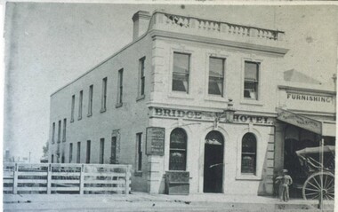 City of Ballarat Libraries
Photograph - Card Box Photographs, Bridge Hotel, Ballarat c1870
The Bridge Hotel was located in Bridge Street. The timber paling fence stopped people falling off the bridge. Next to the hotel was the premises of Wheeler & Wilson Sewing Machines.bridge hotel, wheeler & wilson, building, commercial, hotel, ballarat, bridge -
 Eltham District Historical Society Inc
Photograph, Fay Bridge, Former Glynn's Dairy Farm, Glynns Road, North Warrandyte, 31 August 2018
Glynn’s farm Originally Section 7, Parish of Nillumbik marked Aborigine Reserve in 1866 Crown Allotment 8, Section 7, Parish of Nillumbik, County of Evelyn, Certificate of Title Volume 4095, Folio 818.835, approx. 93 acres purchased by Joseph Panton in 1881 for £1/acre and known as Panton’s Point. By 1924 owned by S.S. Sergeant and called Riverswood. Sergeant commissioned Edna Walling to design the garden. In September 1929 the property was sold at auction by Mortgagee’s sale. Described as well built, brick, tile roof, Attic Villa containing downstairs 7 good rooms, bath, scullery, inside lavatory, etc. Upstairs 2 bedrooms and sleep out. Outbuildings compromising of brick and weatherboard wash house, stables, workshop, feed room, cow bails, large G.I. Hay shed, etc In January 1931 Riverswood property was proclaimed a sanctuary for native game for the entire year. A private swing bridge crossed the river at Pound Bend was known as Pearson’s bridge after C.W.K. Pearson who bought Riverswood in the early 1930s. The bridge was swept away in the December 1934 floods. Riverswood was sold by C.W.K. Pearson at auction on 25 November 1936. Described as a beautiful farm home of 93 acres and over one mile of River Yarra frontage, modern brick residence, lovely garden, rich river flat pastures, model poultry farm. The fine brick home was destroyed on Black Friday (13 Jan.) 1939. It was still a ruin when the Evelyn Evans purchased Waikowhane above Riverswood in 1940. The Glynn family purchased the Riverswood property in 1941 from Robert and Emily Hannon. Their son Kenneth Patrick Glynn inherited the property and he set about clearing the land during WW2 selling wood. Prior to marriage, Kenneth was living alone on the farm in a house he had built from whatever was available. He used the bluestone foundations from the original fine brick home. He met and married Honora Elizabeth Drew in early 1945 and their daughter Anna grew up on the farm. It was compulsorily acquired by the Board of Works in 1976 who then rented the house out in the 1980s. The property was transferred to Melbourne Parks and Waterways in 1996. Waikowhane was a pretty timber house built on top of the hill on 50 acres above Riverswood by retired nurse Jessie MacBeth. (This would be at the intersection of Glynns Road and Overbank Road where the big water tank is now situated on what was once James Orford’s property.) It was also destroyed Black Friday and she rebuilt it from the plans living in a caravan on site supervising the build. It was almost complete when she died May 1939. The property was bought by Evelyn Evans (a city girl) and her estranged husband in 1940. She had two sons, one only 9 months old at the time. It was a timber house with no power or water connected. The Ewen Cameron family bought Waikowhane in 1957. They had to evacuate when the 1961 bushfires swept through. The house was saved by Matcham Skipper. It was demolished by Melbourne Water in the 1990s when they acquired it.fay bridge collection, 2018-08-31, glynn's, glynn's dairy farm, glynns road, north warrandyte, parks victoria, ruins, riverswood, kenneth patrick glynn -
 Greensborough Historical Society
Photograph - Digital Image, Greensborough Bluestone Bridge, circa 1960, 1960s
View of Greensborough bluestone bridge, circa 1960. The bridge was demolished in 1974. Digital copy of colour photographbluestone bridge greensborough -
 Greensborough Historical Society
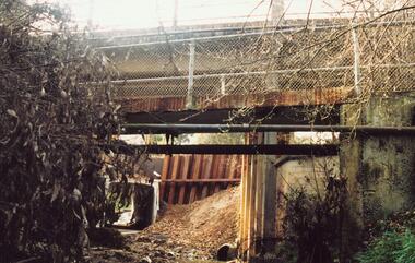
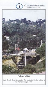
Photograph - Digital Image, Greensborough Rail Bridge 1978, 1978_
A view of the Greensborough rail bridge in 1978. The excavation in the cutting is for the new bridge.Digital copy of one page of a newslettermain street greensborough, greensborough railway station -
 Eltham District Historical Society Inc
Folder, The Erection of a reinforced bridge at Hurstbridge
Photocopied contract for construction of reinforced concrete bridge by the Shire of Eltham at Hurstbridge dated 5th February 1917, including general conditions of contract. This bridge is known as the Monash bridge.10 PagesHG Folders 115harry gilham collection, hurstbridge, monash bridge, contract -
 Greensborough Historical Society
Photograph, Trestle Bridge Eltham April 1979, 17/04/1979
A photograph of the railway trestle bridge at Eltham. Built in 1902, it is the only railway bridge of predominantly timber construction that is still in regular use. The bridge is listed on the Victorian Heritage Database.1 colour photograph.peter graham, eltham, trestle bridge eltham -
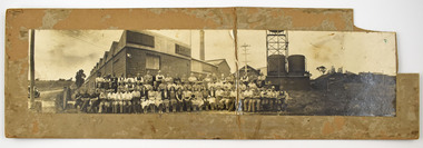 National Wool Museum
Photograph - Staff Group Portrait, Collins Bros Mill Pty Ltd, 1930s-1940s
The Collins No. 2 Woollen Mill building dates from around the 1930s, however related buildings at that site were first constructed from around 1918, that was the Marnock Vale Wool Scouring Works. The Union Woollen Mill founded in the 1870s by William Henry Collins, a major Geelong industrial enterprise, was among the local firms which flourished during the First World War period. From 1914-1918 Collins Bros. concentrated on equipment for the A. I. F. However, afterwards Collins Bros. Pty. Ltd. specialised in the manufacture of flannels and blankets. From 1920 to 1938 the output was increased by fifty percent, and the number of employees rose to 200. The Collins Bros. No. 2 Mill was established in Bridge Street, Newtown. The proprietary brand 'Physician' became well and favourably known throughout Australia source: Heritage Victoria The Collins Bros Mills No. 1 and No. 2 hired over 250 people, and produced between 40,000 and 60,000 blankets for both the Australian market and for overseas export. Collins Bros closed both mills in 1974.Landscape photograph mounted on board showing a group portrait of staff seated and standing together in front of the Collins No. 2 Woollen Mill, Bridge Street, Newtown. Buildings, a chimney, towers, tanks, farmland, a car, powerlines and dirt roads are shown in the background. -
 Ballarat Tramway Museum
Document - Instruction, State Electricity Commission of Victoria (SECV), "Important Instruction to Motormen and Conductors Shunting of Trams in Bridge Street", 17/03/1965 12:00:00 AM
Has a strong association with the Ballarat tram crews and yields information about the shunting of trams in Bridge St and the hazards in doing this.Quarto typed instruction, titled "Important Instruction to Motormen and Conductors Shunting of Trams in Bridge Street" about not shunting trams in Bridge St due to traffic hazard when turning the pole on trams. Trams to use Main St. Prepared by Les Denmead. Dated 17/3/1965 and signed by F.K. White as SEC District Manager.has handwritten note in ink in top left hand corner "Depot Foreman Please Post"trams, tramways, instructions, bridge st, police