Showing 15309 items
matching mt-joonawara
-
 Buninyong & District Historical Society
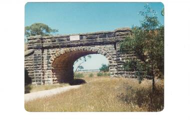
Photograph - Colour photograph, Blue Bridge Mt. Doran
View of bluestone railway bridge built as part of the 1858 project to link Ballarat to GeelongThe building of the railway between Ballarat and Geelong contributed to significant change within the districtView of the bluestone railway bridge near ClarendonBlue Bridge 1988landscape, clarendon, railway, transport -
 Marysville & District Historical Society
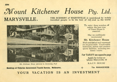
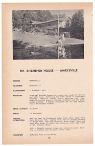
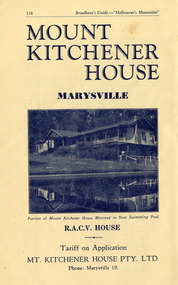
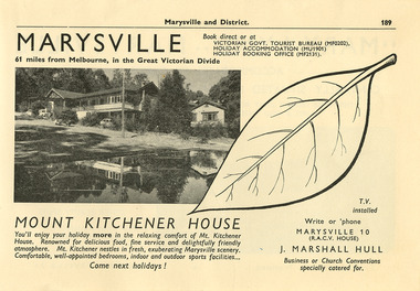
Ephemera (item) - Information booklet advertisement, Broadbent's Official Road Guides Company, MT. KITCHENER HOUSE - MARYSVILLE, Unknown
An advertisement for Mount Kitchener House in Marysville taken from a Broadbent's accommodation guide.An advertisement for Mount Kitchener House in Marysville taken from a Broadbent's accommodation guide.marysville, victoria, australia, mount kitchener house, mt kitchener house, kitchener house, accommodation, broadbent's accommodation guide -
 Linton and District Historical Society Inc
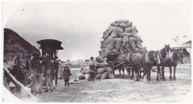
Photography, Gillet Bros. Carting Chaff, Mt Mercer area
Black and white copy of original photograph of fully loaded wagon of chaff bags behind a team of horses. To the left are men standing in front of machinery, to the right building with windmill in background.gillett brothers, chaff, horses, farming -
 Linton and District Historical Society Inc
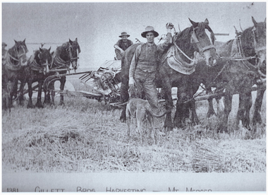
Photography, Gillett Bros. Harvesting at Mt Mercer
Photocopy of mounted photograph no.510, showing 2 teams of horses and men harvesting a paddock.gillett, harvesting, farming, horses, mt mercer -
 Marysville & District Historical Society
Ephemera (item) - Information booklet advertisement, Broadbent's Official Road Guides Company, MT. KITCHENER HOUSE - MARYSVILLE, Unknown
A digital copy of an advertisement for Mount Kitchener House in Marysville that was taken from a Broadbent's accommodation guide.A digital copy of an advertisement for Mount Kitchener House in Marysville that was taken from a Broadbent's accommodation guide.marysville, victoria, australia, mount kitchener house, mt kitchener house, kitchener house, accommodation, broadbent's accommodation guide -
 Whitehorse Historical Society Inc.
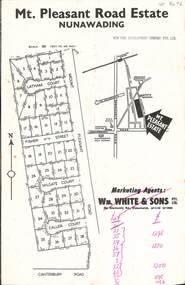
Document, Mt. Pleasant Road Estate, 1960's
A marketing document for Mt. Pleasant Road Estate.non-fictionA marketing document for Mt. Pleasant Road Estate.mount pleasant road estate, william white and son -
 Linton and District Historical Society Inc
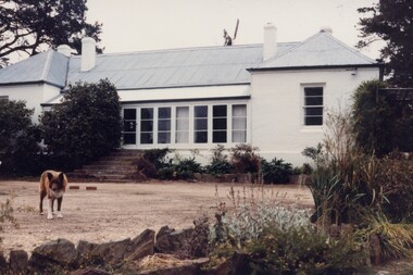
Photograph, Mt Bute Homestead circa 1982, 1982
Colour photograph of a long white older style home with pitched roof set in gardens. Brown dog in foreground.mt bute homestead 1982, buildings -
 Marysville & District Historical Society
Ephemera (item) - Information booklet advertisement, Broadbent's Official Road Guides Company, MT. KITCHENER HOUSE - MARYSVILLE, Unknown
An advertisement for Mount Kitchener House in Marysville taken from a Broadbent's accommodation guide.An advertisement for Mount Kitchener House in Marysville taken from a Broadbent's accommodation guide.marysville, victoria, australia, mount kitchener house, mt kitchener house, kitchener house, accommodation, broadbent's accommodation guide -
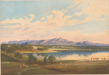
 Federation University Art Collection
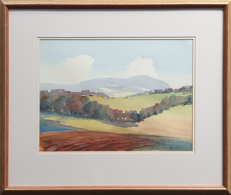
Painting - Watercolour, David Alexander, 'Mt Buninyong in Autumn' by David Alexander, 2001, 2001
Gift of Dr David Alexander, 2013Framed watercolour by David Alexander showing a landscape with Mount Buninyong in the distance. LRS 'D. Alexander'01art, artist, david alexander, watercolour, buninyong, mount buninyong, available -
 Melbourne Tram Museum
Drawing - List, Melbourne Tramway and Omnibus Co (MTOCo), "MT&OCo Standard lettering', 14/9/1898
Provides a list of the lettering to be painted on the cable trams operated by the Melbourne Tramway and Omnibus Co. (MTOCo) including horse trams and horse omnibus routes. Dated 14/0/1898. Yields information about the signage applied to the Melbourne cable trams by the MTOCo. in 1898.Drawing or list black ink on linen.tramways, cable trams, mtoco, signs, grip car, dummy, trailes, horse buses, horse tram -
 Stawell Historical Society Inc
Slide, Set of Large Format colour positive slides of Great Western c1970 - Mt Langi Giran from winery
Believed taken by Ian McCann Stawell's first Tourism OfficerLarge format Positive Colour Slides -
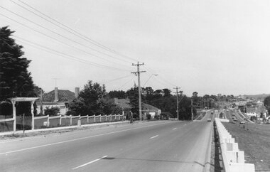 Ringwood and District Historical Society
Photograph, Maroondah Highway East, Ringwood- 1969. Looking west towards Ringwood approaching Mt Dandenong Road
Black and white photograph -
 Stawell Historical Society Inc
Book, LRGM Services, Heritage Action Plan Heatherlie (Mt Difficult) Quarry 2002
Produced for Parks Victoria Grampians National Parks By LRGM Services.A4 Spiral Bound PhotocopiesLRGM Services Heritage Consultants Robert J Kaufmangrampians national park -
 Darebin Art Collection
Painting, Sharon West, Mt. Cooper Estate, 2002
mt cooper -
Stawell Historical Society Inc
Book, Mt. Difficult Heatherlie Quarry
Green covered A4 NotesApplication for Listing on the Historical Building Register -
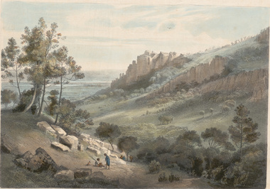 Horsham Regional Art Gallery
Print, Nicholas CHEVALIER, West side of Mt Arapiles, c. 1865
Purchased through the Horsham Art Gallery Trust Fund, 2006 -
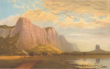 Horsham Regional Art Gallery
Print, Nicholas CHEVALIER, Mt Arapiles sunset, c. 1865
Gift of the Friends of Horsham Art Gallery, 1999 -
 Horsham Regional Art Gallery
Print, Nicholas CHEVALIER, Mt Zero and the Grampians, 1864
Gift of Dr Jeff Jenkinson, 2005 -
 Kiewa Valley Historical Society
Photos, Postcards - Kiewa Valley
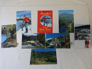
Mt Beauty township, at the head of the Kiewa Valley, is situated at the foot of Mt Bogong. The town was established by the State Electricity Commission of Victoria during the construction of the Kiewa Hydro Electric Scheme on the High Plains.Mt Beauty is a popular tourist resort. The main highway from Mt Beauty to the Bogong High Plains is most picturesque throughout the year. During the winter months, Falls Creek provides access to Falls Creek Ski Village for snow sports. Tawonga, 6.5 km north of Mt Beauty, is famed for its trout fishing and camping on the Kiewa River. Deciduous trees make a show of colour during Autumn. The postcards are of historical value showing photos taken at an earlier time.The postcards can be compared to the attractions of the time as they do not include cycling (mountain bikes and road bikes), snow boarding, gliding and paragliding. Advertising for tourism has also changed as attractions are now available on-line. 1. 9 Coloured Photos of Bogong (5) and Visitors Information Centre display (4) 2. Two fold out coloured sets of postcards "Mt Beauty and the Kiewa Scheme", "Mt. Beauty Victoria" 3. x10 Coloured postcards Mt Beauty, Kiewa Valley, Bogong 4. x6 Coloured postcards High Country and Bogong Villagepostcards kiewa valley -
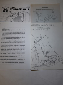 Kiewa Valley Historical Society
Papers - Mt Beauty Pondage Walk
The Mt Beauty area is picturesque during each of the seasons and therefore an attraction for tourists. During the 1980s and 1990s the Pondage Walk was popular as visitors were able to borrow a tape recording and stop along the way listening to the history of the area.After the completion of the Kiewa Hydro Electric Scheme Mt Beauty became a tourist destination. The walks are popular and vary in length, difficulty and duration. Papers describing walks in the Mt Beauty area including the Mt Beauty Pondage Walk. Includes maps of the walks.mt beauty pondage walk, tourism -
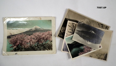 Bendigo Military Museum
Photograph - PHOTOGRAPHS, BCOF, MT FUJI, possibly pre war
Items in the collection re Clarence Shearing, refer Cat No 7089.16P for his service details.Six photos various sizes two in colour four in B & W relating to Mt Fuji in Japan. One colour card has an enscription on the bottom.On one, "Mt FUJI seen from Lake Kawagauchi in springtime"photographs, bcof, mt fuji -
 Federation University Historical Collection
Photograph, Bill Durant, Ballarat Institute of Advanced Education Physics Building, 02/1974
The physics building was one of the early buildings built on Mt Helen campusColour transparency of Mt Helen Campus S Building under constructionbuildings, physics, bill durant -
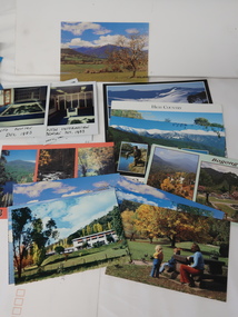
 Kiewa Valley Historical Society
Postcards - Mt Beauty and Falls Creek
Mt Beauty and Falls Creek are tourist destinations. The postcards advertise the beauty of the area.These photos are a record of Mt Beauty and Falls Creek in different seasons and over time.Large x2 of Falls Creek and one of Mt Beauty - with envelopes including a 1980 22c stamp; Small x7 of Mt Beauty. All are coloured photos with titles on the back and lines to write an address or message.mount beauty tourism, postcard photos -
 Kiewa Valley Historical Society
Alex McCullough Collection - Notes and Photos on History of Mt Beauty
Alex McCullough was a resident of Mt Beauty for many years and wrote a book on the History of Mt Beauty. Mt Beauty was constructed by the State Electricity Commission of Victoria to house employees working on the Kiewa Hydro Electric Scheme. Alex was involved with many organisations in Mt Beauty and interested in history. He took many photos of events and new developments in town. He also collected individuals memoirs on life in the town.Mt Beauty's history is unique as it was built as a construction town in the late 1940s. The information in Alex's Collection records the town's development perhaps in more detail than in his book "The History of Mt Beauty". His folder includes his education, his work with the SECV (foreman working on Clover Dam), his war service, his community work (Mt Beauty & District Progress Association & Mt Beauty Neighbourhood Centre) and awards, work as Shire Councillor and Mayor, sporting (tennis & golf) interests. Alexander John McCullough 1916 - 2011's obituary is online ref. legacy.comA) Booklet - The Life of Alex McCullough B) Booklet - The Story of Kiewa by Alex McCullough C) Coloured photos 15cm x 10 cm of the renovation of the Mt Beauty Neighbourhood Centre mid 2001. Four photos are labelled by Alex McCullough on the back. Also, photos of various sizes both colored and black and white depicting sites and people in Mt Beauty. Not labelled.Also, six packets of negatives of older photos incl. Community Hall, Fire Brigade, School, School ski group, Back to Kiewa, Alpine Study, D) Alex McCulloughs 1951 Diary - Clover Dam E) Random Items from History Profile Kiewa by Alex McCullough F) Papers - 'Administration of Mt Beauty Township' - 2nd July 1957. SECV buildings in Mt Beauty shared with community groups notes re - arrangement between groups. G) Barrie Wilcox's Memories living in Marum's paddock from c1940s onwards. Written in June 1999 H) Mt Beauty website June 1998 - a lot of history I) Papers - Mt Beauty High School band developement J) The 1950s Development of the Birth of Community support organisations K) Community Centre Mt Beauty opening 3rd August 1951 L) Mt Beauty Fire Brigade History M) Folder Personal papers re Alex McCullough alex mccullough, mt beauty history, community work -
 Kiewa Valley Historical Society
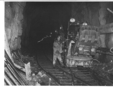
Photograph of Rail Mounted Battery operated soil Bucket, between 1941 and 1946
This machine was in use in the 1940's during the construction of the tunnels for the Hydro Electric scheme. This particular photograph was taken in the Tailrace Tunnel which brings water from West Kiewa Power Station to the open tailrace in Mt. Beauty and then into the regulating pondage before discharge into the Kiewa River. This machine (or one similar) is on display on the Northern side of the entrance to the Visitor's Centre. The tailrace tunnel (or West Kiewa tunnel) was commenced in 1947 from both ends and the breakthrough occurred on 22nd. July, 1950Shows the size of the tunnel and the machinery used for excavation in the 1940's/50's.Black and white photographHandwritten on back of photograph "Jumbo" in Tailrace Tunneltunnel, machinery, water, tail race -
 Halls Gap & Grampians Historical Society
Photograph - B/W, C 1930s-1940s
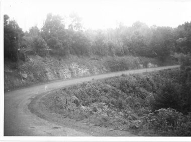
Mt Victory Rd once known as the Bluff road was opened by Lady Somers Mar 1930. This section of the raod is beyond Stoney Creek Gorgephoto shows sweeping bend on Mt Victory Rdaccess routes, mt victory rd, roads -
 The Beechworth Burke Museum
Geological specimen - Chalcopyrite
This specimen originated from Mount Lyell on the west coast of Tasmania, where a large group of open cut and underground copper-silver-gold mines began operating in 1883. Between 1893-1994, the Mt Lyell Mining and Railway Company were responsible for operations. The Mt Lyell copper-gold mines produce some excellent crystallised specimens of chalcopyrite and other minerals. The deposits are generally considered to be of Cambrian volcanic origin, but there are indications of Devonian granitic influence on the ores, plus local remobilisation during Devonian deformation. Over 120 million tonnes of ore was produced from several workings, including the main Prince Lyell mine and the North Lyell mine, which was also of great importance. The Mount Lyell mines have a long history of human and environmental disasters, including the 1912 North Lyell fire that killed 42 miners, and two separate incidents in 2013 in which three people lost their lives. The environmental impacts from this complex of mines are extensive, with waste tailings and heavy metal contamination flowing directly into the King and Queen River catchments. In 1954, the eminent Australian historian, Geoffrey Blainey, published 'The Peaks of Lyell' which delves into the history of the 1912 North Mount Lyell Disaster.Chalcopyrite does not contain the most copper in its structure relative to other minerals, but it is the most important copper ore since it can be found in many localities and occurs in a variety of ore types. The brassy-yellow colours in Chalcopyrite mean it is often confused with pyrites and gold, leading to use of the term, "fool's gold." Chalcopyrite has been the primary ore of copper since smelting began five thousand years ago. This specimen is part of a larger collection of geological and mineral specimens collected from around Australia (and some parts of the world) and donated to the Burke Museum between 1868-1880. A large percentage of these specimens were collected in Victoria as part of the Geological Survey of Victoria that begun in 1852 (in response to the Gold Rush) to study and map the geology of Victoria. Collecting geological specimens was an important part of mapping and understanding the scientific makeup of the earth. Many of these specimens were sent to research and collecting organisations across Australia, including the Burke Museum, to educate and encourage further study.This hand sized solid mineral specimen has shades of brass-yellow with spots of iridescent green-black tarnish. Chalcopyrite is a copper iron sulphide mineral and a major ore of copper common in sulphide veins and disseminated in igneous rocks. Chalcopyrite has a hardness of 3.5-4 on the Mohs Scale. It is a member of the tetragonal crystal system and has metallic lustre and opaque transparency.burke museum, beechworth, indigo shire, beechworth museum, geology, geological specimen, chalcopyrite, copper pyrites, copper mining, tasmanian geology, mount lyell, mount lyell mines, fools gold, mohs scale, crystals, minerals, historical geological collection, victorian geological survey, a.r.c selwyn, gold rush, van diemans land -
Clunes Museum
Painting, F.R. ANDERSON
SILVER PAINTED WOODEN FRAMED PAINTING UNDER GLASS. BLACK BACKGROUND. DRAWING OF MT. BECKWORTH FLOWERS BY F.R. ANDERSON, CRESWICK. FLOWERS NAMED ON BACK OF PAINTINGON BACK LIST OF FLOWERS. MT. BECKWORTH FLOWERS BY F.R. ANDERSON, CRESWICKmt beckworth, flowers -
 Kiewa Valley Historical Society
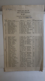
Papers - Voters Roll - Mt Beauty 1960/61
Mt Beauty, South Riding, was part of the Shire of Bright in 1960/61. Mt Beauty was handed over by the SECV to the Bright Shire when the Kiewa Hydro Electric Scheme was completed in 1961.Mt Beauty was a construction town built in the late 1940s.Mt Beauty was a construction town built by the SECV and run by the SECV until 1961 when it was handed over to the Shire of Bright. This list of residents is an indication of how many SECV employees remained in the town and what work they were doing.9 foolscap pages of alphabetical lists of, residents of Mt Beauty, their addresses, occupations etc. The pages are held by 3 staples.C. Roper on the front pagemt beauty, shire of bright, voters' roll 1960/61, mt beauty residents, mt beauty householders