Showing 14772 items
matching north road
-
 Whitehorse Historical Society Inc.
Map, City of Whitehorse, 1/03/1995 12:00:00 AM
... Mullum Creek to the north to Highbury Road and Warrigal Road... of Whitehorse from Mullum Mullum Creek to the north to Highbury Road ...Map showing streets of the City of Whitehorse from Mullum Mullum Creek to the north to Highbury Road and Warrigal Road in the west, to Heatherdale Road in the east.Map showing streets of the City of Whitehorse from Mullum Mullum Creek to the north to Highbury Road and Warrigal Road in the west, to Heatherdale Road in the east. Prep. by Richard Meloni. Scale 1:15,000Map showing streets of the City of Whitehorse from Mullum Mullum Creek to the north to Highbury Road and Warrigal Road in the west, to Heatherdale Road in the east. city of whitehorse, mullum mullum creek -
 Linton Mechanics Institute and Free Library Collection
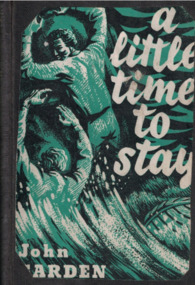
Book - Novel, Garden, John, A little time to stay, 1953
... : 'The Roundabout Book Club, 55 Kooyong Road, North Caulfield' ; 'Mooroopna... Kooyong Road, North Caulfield' ; 'Mooroopna Mechanics Hall & Free ...286 p. :black cover, with image (probably cut from original dust jacket) of two men struggling to climb rocks, with waves below.fictionfiction, john garden -
Glen Eira Historical Society
Document - Kooyong Road, 110, Caulfield North
... Kooyong Road, 110, Caulfield North... Road, Caulfield North from 1840 to 1985. Accompanied...110 Kooyong Road, Caulfield North, Victoria, Australia.../tenants of 110 Kooyong Road, Caulfield North from 1840 to 1985 ...Copy of typed letter 27/05/1989 from Brighton Historical Society giving details of history/owners/tenants of 110 Kooyong Road, Caulfield North from 1840 to 1985. Accompanied by handwritten working notes naming owners/tenants of property 110 Kooyong Road, North Caulfield from 1936 to 1985. House was built in 1936.kooyong road, rosemont farm, howitt godfrey dr, settlers, caulfield north, howitt alfred, henderson garnet w., henderson m.m. miss, haskin joseph, anstee w.e., holst edward, bullock hilary, landells rosalind, land subdivision -
 Ringwood and District Historical Society
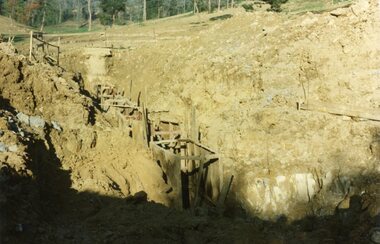
Photograph, Kubis Estate, North Ringwood on 10 June 1978. Trench for sewer below the manhole
... of the "Kubis" Estate, Ringwood North, including road works to Debbie... Road Ringwood North melbourne E550 N7 The hole for the 27 feet ...E550 N7 The hole for the 27 feet deep well shows as a white patch, lower right. Part of a 51-photo record of the development of the "Kubis" Estate, Ringwood North, including road works to Debbie Place, Kubis Drive, Werac Drive, Manuelo Drive, Iluka Place and Glenvale Road. From the Jack Lundy Clarke collection. -
 Melbourne Tram Museum
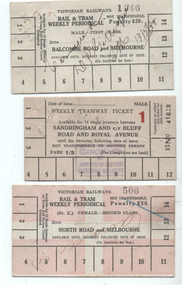
Ephemera - Rail & Tram weekly tickets, Victorian Railways (VR), c1935
... 3 - North Road and Melbourne - white card overprinted... 3 - North Road and Melbourne - white card overprinted ...Set of three Victorian Railways Rail & Tram weekly Periodicals with conditions of travel on the rear, See reference page 124 and Figure 6-27. Such tickets were introduced on 1/7/1939. All tickets were available for 14 tram trips only, but unlimited rail trips: 1 - Balcombe Road and Melbourne - First Class - white card - No. 1346, marked cancelled 13/5/1939 2 - Sandringham and cnr Bluff Road and Royal Ave - white card - Male, No. 41618, price 1/3 with a red 1 (first class?) - stamped cancelled 3 - North Road and Melbourne - white card overprinted in pink to leave a cross, Female, No. 506, Second class, with cancelled hand written on the front.Demonstrates a Victorian Railways Rail and Tram weekly tickets for both their tramways and the changes made over time. May have been used for training samples.Set of three printed card tickets with over printing and hand writing as shown.tickets, vr, vr trams, victorian railways, st kilda brighton tramway, weekly tickets, sandringham to black rock -
 Whitehorse Historical Society Inc.
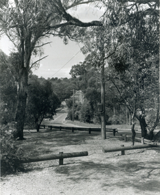
Photograph, Deep Creek Road, Mitcham, 1/09/2000 12:00:00 AM
... Black and white photo looking North along Deep Creek Road...Whitehorse Historical Society Inc. 2-10 Deep Creek Road ...Black and white photo looking North along Deep Creek Road, Mitcham, from Car Park at Schwerkolt Cottage Museum Complex.mitcham -
 Whitehorse Historical Society Inc.
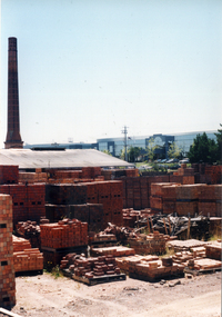
Photograph, Vitclay, 1995
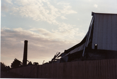
... , with demolished shed in foreground. Springfield Road, Blackburn North... Mitcham melbourne vitclay springfield road blackburn north ...Vitclay Chimney, prior to demolition in 1995, with demolished shed in foreground. Springfield Road, Blackburn North, looking South from Primrose Street.vitclay, springfield road, blackburn north, potteries, clay industries -
 Whitehorse Historical Society Inc.
Photograph, Vitclay, 1995
... by demolished sheds. Springfield Road, Blackburn North, looking West... Mitcham melbourne vitclay springfield road blackburn north ...Vitclay Chimney, prior to Demolition in 1995, surrounded by demolished sheds. Springfield Road, Blackburn North, looking West from Primrose Street.vitclay, springfield road, blackburn north, potteries, clay industries -
 Tarnagulla History Archive
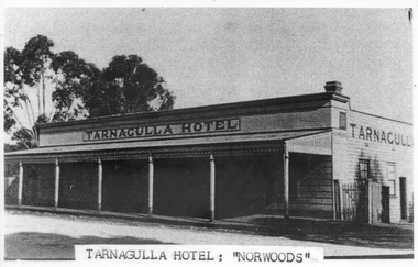
Photograph, Tarnagulla Hotel (Norwood's), Tarnagulla
... (also known as Norwood's) in Tarnagulla. Was on Commercial Road... Road just north of King Street. Copy photograph. Tarnagulla ...Donald Clark Collection. A monochrome photograph depicting the Tarnagulla Hotel (also known as Norwood's) in Tarnagulla. Was on Commercial Road just north of King Street. Copy photograph. hotels, commercial road -
 Tarnagulla History Archive
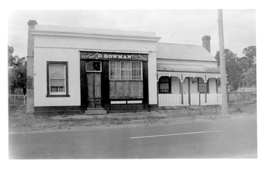
Photograph of Bowman's Bakery building, at 64 Commercial Rd, Tarnagulla, Bowman's Bakery building, Tarnagulla, Late 1960s
... Murray Comrie Collection. Still located at the north end... located at the north end of Commercial Road, Tarnagulla ...Murray Comrie Collection. Still located at the north end of Commercial Road, Tarnagulla.Monochrome photograph depicting building once used as G.Bowman's shopfront and adjacent dwelling in Tarnagulla.tarnagulla, commercial road, commerce, shopfronts, shops, businesses, bakery, food, stockfeed, grains, agriculture -
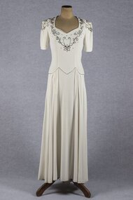 Brighton Historical Society
Clothing - Dress, Wedding dress, 1941
... at 54 North Road, Brighton. They had five children, Michael... at St James Catholic Church, North Road, Gardenvale. They had ...Worn by three brides in 1941, 1944 and 1948. The dress was made for Eva Elizabeth (Bid) Harvey for her marriage to Morris Langlo West on 2 October 1941 at St James Catholic Church, North Road, Gardenvale. They had two children, Julian (1942-2005) and Sr. Elizabeth West (born 1942). Bid was born in 1906 to Michael and Kitty Harvey. They lived at 51 Cole Street, Elwood. The bridesmaid was Bid's niece Jocelyn Hickey. The dress was also worn by Jocelyne Dorothy Taylor when she married John Carlisle (Carl) Harvey (Bid's brother) at James Catholic Church, Gardenvale on 30 June 1944. Jocelyne's bridesmaid was Jocelyn Hickey and the best man was Basil Robinson. The reception was held at 'Birdwood', Birdwood Avenue, Brighton. Jocelyne was born in Rangoon, Burma in 1921 and was the eldest daughter of Stanley and Dorothy Taylor. Carl was the only son of Michael and Kitty Harvey. Jocelyne and Carl lived at 15 Harwood Street, Elwood and later at 54 North Road, Brighton. They had five children, Michael, David, Jennifer, Robert and Eric. The third bride to wear the dress was Jocelyn Mary Hickey, who was bridesmaid to Bid and Jocelyne. Jocelyn Hickey was born in 1929 to Daniel and Doreen Hickey (Bid's sister and Jocelyne's sister-in-law). Jocelyn married Gerard Leslie O'Donnell at St James Catholic Church, Gardenvale in 1948. The bride's attendants were Adita Smith, Maureen Bow and Jacqueline Connell. The groom's attendants were Jack Fallon and Con O'Donnell. The reception was held at 51 Cole Street, Elwood. Jocelyn and Gerard had three daughters, Maree, Carlene and Janine. They lived in Bunyip, Victoria. (Information provided by the donor).Cream crepe wedding dress with short sleeves and dropped waist. Sweetheart neckline, bodice and sleeves decorated with floral design in bugle beads. Fastens with metal zip in left side seam.wedding dress, wartime bride, 1940s, eva elizabeth harvey, jocelyne dorothy taylor, jocelyn mary hickey -
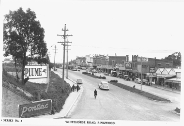 Ringwood and District Historical Society
Photograph, Maroondah Highway Central, Ringwood. Whitehorse Road looking west from Warrandyte Road. c1930's
... , Ringwood. Image shows shops on north side of road from Warrandyte..., Ringwood. Image shows shops on north side of road from Warrandyte ...Black and white photograph (2 copies)Inscribed on photograph: "Series No 4. Whitehorse Road, Ringwood. Image shows shops on north side of road from Warrandyte Road railway bridge to Ringwood Street. -
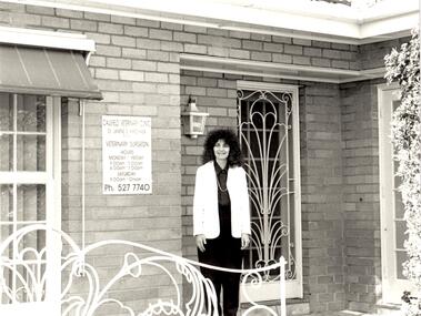 Glen Eira Historical Society
Document - Animals
... . These include photographs of the ‘Caulfield Veterinary Clinic, North... of the ‘Caulfield Veterinary Clinic, North Road Ormond dated 1982, Animal ...This file contains 2 items: 1/A black, white and green brochure titled ‘Leash Free Parks and Reserves’ concerning leashing regulations, conditions for non-leashing, summaries of legislation and penalties for owners of dogs, written by the City of Glen Eira. It includes six illustrations and a map of Glen Eira which labels all leash free parks as well as a depiction of all the train stations in the area. 2/A collection of 37 black and white photographs which have all appeared in Caulfield Contact at some time. These include photographs of the ‘Caulfield Veterinary Clinic, North Road Ormond dated 1982, Animal Control officer Reg Dixon dated 1982, draught horses pulling a horse drawn cart dated 1988 and general animals. Photographs unknown.allnutt park, murrumbeena park, veterinary clinics, professionals, veterinarians, kirschner jane s., north rd. ormond, dixon reg, animal control officer, horses, racehorses, racecourses, draught horses, bailey reserve, sporting grounds, bentleigh/hodgson reserve, boyd park, neerim road, caulfield park, caulfield race course, duncan mackinnon park, ee gunn reserve, glen huntly park, joyce park, king george v1 memorial reserve, lords park, marara road, marlborough street reserve, moorleigh, victory park, princes park, packer park, animal enclosures, domestic animals, dogs, horse drawn vehicles, cattle, birds, animals, trains, caulfield contact -
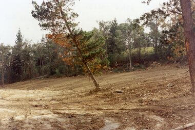 Ringwood and District Historical Society
Photograph, Site of Loughnan's Lake, North Ringwood in April 1978
... , Ringwood North, including road works to Debbie Place, Kubis Drive... Road Ringwood North melbourne E548 N33 The leaning pine tree ...E548 N33 The leaning pine tree grew on the lake shore after 1950. It also was used as a rope tree by the children. Part of a 51-photo record of the development of the "Kubis" Estate, Ringwood North, including road works to Debbie Place, Kubis Drive, Werac Drive, Iluka Place and Glenvale Road. From the Jack Lundy Clarke collection. -
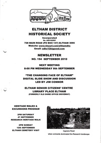 Eltham District Historical Society Inc
Newsletter, Newsletter, No. 194 September 2010
... Names; The North-South Roads • More News ... Names; The North-South Roads • More News The Shire of Eltham ...Contents: • Next meeting, Slide Show and Discussion led by Jim Connor: The Changing Face of Eltham • September Meeting • Research Heritage Walk • Eltham Cemetery Visit • Distinguished Life Members by Jim Connor • Jock Read’s Early History • Local Road Names; The North-South Roads • More News The Shire of Eltham Historical Society was formed in October 1967. The first newsletter of the Society was issued May 1978 and has been published continuously ever since on a bi-monthly basis. With the cessation of the Shire of Eltham in late 1994, the Society's name was revised to Eltham District Historical Society and this name first appeared with issue No. 103, July 1995. The collection of the Society's newsletters provides a valuable resource on the history of the Society's activities, office bearers and committee members, guest speakers and subjects of historical interest pertinent to the former Shire of Eltham and the Eltham District.A4 photocopied newsletter distributed to membersnewsletter, eltham district historical society, shire of eltham historical society -
 Whitehorse Historical Society Inc.
Photograph, Daniel Robertson Australia, 2000
... and Chimney, looking North East towards Norcal Road. The Holeproof...Whitehorse Historical Society Inc. 2-10 Deep Creek Road ...Photo taken of Daniel Robertson Brickworks Storage Area and Chimney, looking North East towards Norcal Road. The Holeproof Factory is located in the background.robertson, daniel, brickworks, chimneys, station street, nunawading, nos. 58 to 74 -
 Whitehorse Historical Society Inc.
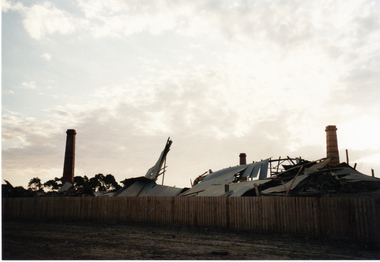
Photograph, Vitclay, 1995
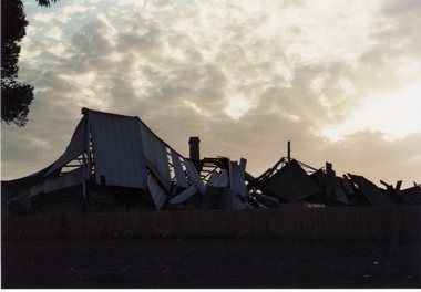
... , with demolished shed in foreground. Springfield Road, Blackburn North... Mitcham melbourne vitclay springfield road blackburn north ...Vitclay Chimneys, prior to demolition in 1995, with demolished shed in foreground. Springfield Road, Blackburn North, looking South-West from Primrose Street.vitclay, springfield road, blackburn north, potteries, clay industries -
 Whitehorse Historical Society Inc.
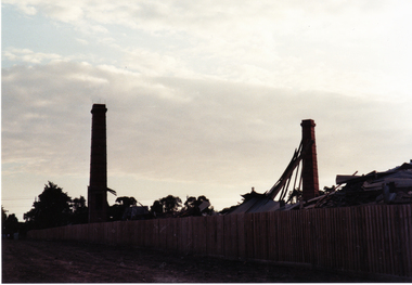
Photograph, Vitclay, 1995
... , with demolished sheds in foreground. Springfield Road, Blackburn North... Mitcham melbourne vitclay springfield road blackburn north ...Vitclay Chimneys, prior to demolition in 1995, with demolished sheds in foreground. Springfield Road, Blackburn North, looking South-West from Primrose Street.vitclay, springfield road, blackburn north, potteries, clay industries -
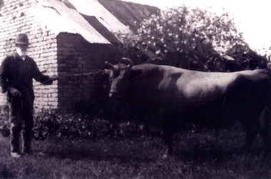 Whitehorse Historical Society Inc.
Photograph, Joseph Tainton with prize bull
... prize bull, 'Foxglove' on his property on the north side...Whitehorse Historical Society Inc. 2-10 Deep Creek Road ...Joseph Tainton emigrated to Australia in 1853 with his parents, James and Ann Tainton. He married Mary Jane Course and they had ten children. He was an orchardist.A photograph of Joseph Tainton taken c1926 holding his prize bull, 'Foxglove' on his property on the north side of Burwood Road, East Burwoodtainton, joseph -
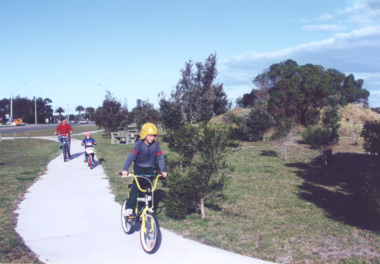 Lakes Entrance Historical Society
Photograph - Cycle pathway between Bullock Island and North Arm Bridge, L E Tidy Town Committee, Lakes Entrance Victoria, 1994 c
... and cycle pathway between Bullock Island Road and North Arm Bridge... Bullock Island Road and North Arm Bridge Lakes Entrance Victoria ...Colour photograph of three cyclists on shared pedestrian and cycle pathway between Bullock Island Road and North Arm Bridge Lakes Entrance Victoria transport, recreation, roads and streets -
Kew Historical Society Inc
Plan - Charteris Estate, Ivanhoe [East], 1927
... : Burke Road North, McArthur Road, Castella Street... within the subdivision include: Burke Road North, McArthur Road ...Subdivision plans and real estate flyers/brochures reveal a number of aspects of urban development and history. The Kew Historical Society's collection of these plans, as well as advertisements extracted from magazines, cover key aspects of community development and architectural history of Kew and Kew Eat as well as surrounding suburbs. While most of the plans in the collection were gifted to the Society by the former City of Kew, a number of other plans and advertisements have been donated by individuals, of which this is an example.Original 4-page bifold handout advertising 43 residential lots for sale in the Charteris Estate subdivision in Ivanhoe [now classified as Ivanhoe East]. This brochure was created to sell the third section of the estate which it labels as 'The Most Superb Section'. Streets within the subdivision include: Burke Road North, McArthur Road, Castella Street, and the Government Boulevard. In addition to the overall plan spread across pages 2 and 3, each page includes a number of interesting photographs including: a number of the new Burke Road Bridge, a sports ground, Hoyts Picture Theatre in Ivanhoe, a croquet ground, and Ivanhoe shopping centre [named Motor Cross Junction].charteris estate - east ivanhoe (vic), subdivision plans -- ivanhoe east (vic.), d.c. mcarthur, charterisville -
Linton Mechanics Institute and Free Library Collection
Book - Novel, Douglas, Bruce (Theodore Wayland Douglas), Border range, [n.d.] [1942?]
... : 'The Roundabout Book Club, 55 Kooyong Road, North Caulfield' ; 'Tatura... collections: 'The Roundabout Book Club, 55 Kooyong Road, North ...Western romantic fiction, in which protagonists battle to defend their land from marauders and gunmen.216 p. ; red cover with image of woman on horse, man walking beside her, cattle and cowboys in distance.fictionWestern romantic fiction, in which protagonists battle to defend their land from marauders and gunmen.westerns, fiction -
Linton Mechanics Institute and Free Library Collection
Book - Novel, Bragg, W. F, Bullet song, 1955
... : "Roundabout Book Club, Kooyong Road, North Caulfield"; "Mechanics... Book Club, Kooyong Road, North Caulfield"; "Mechanics ...Western fiction157 p. fictionWestern fictionfiction, westerns, w. f. bragg -
 Eltham District Historical Society Inc
Slide - Photograph, Bells Hill Road, Research, c.May 1988
... Looking north along Bells Hill Road at intersection... melbourne Looking north along Bells Hill Road at intersection ...Looking north along Bells Hill Road at intersection with Kybrolyde Ct, Research, May 198835mm colour positive transparency (1 of 36) Mount - Kodak KodachromeProcess Date MAY 88Mbells hill road, infrastructure, kybrolyde ct, research (vic.), roads -
 Eltham District Historical Society Inc
Slide - Photograph, Bells Hill Road, Research, c.May 1988
... Looking north along Bells Hill Road at intersection... melbourne Looking north along Bells Hill Road at intersection ...Looking north along Bells Hill Road at intersection with Kybrolyde Ct, Research, May 198835mm colour positive transparency (` of 36) Mount - Kodak KodachromeProcess Date MAY 88Mbells hill road, infrastructure, kybrolyde ct, research (vic.), roads -
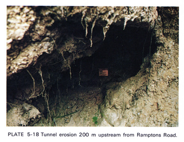 Eltham District Historical Society Inc
Work on paper (Sub-Item) - Photograph, Tunnel erosion 220 m upstream from Ramptons Road
... from Ramptons Road, Eltham North ... from Ramptons Road, Eltham North eltham erosion eltham north ...Colour photograph of tunnel erosion 220 metres upstream from Ramptons Road, Eltham North eltham, erosion, eltham north, drain -
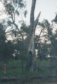 Sunbury Family History and Heritage Society Inc.
Photograph, 18th October 1998
... Road just north of the Langley State School.... The Aboriginal scarred tree was growing along the Redesdale Road just ...The Aboriginal scarred tree was growing along the Redesdale Road just north of the Langley State School.The scarred tree is evidence of Aboriginal technology as the bark from such trees was used for many items. A coloured photograph of a scarred tree with other smaller trees in the background. The tree has a yellow cross painted on its trunk.scarred trees, aboriginal society, aboriginal technology, langley -
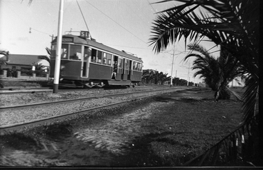 Melbourne Tram Museum
Negative, Wal Jack collection, 1940's
... in the reservation, Mount Alexander Road, North Essendon. Tram number... in the reservation, Mount Alexander Road, North Essendon. Tram number ...Black and white negative by Wal Jack of W5 741 outbound in the reservation, Mount Alexander Road, North Essendon. Tram number identified on print in album. Has the destination of Essendon, Route 51 Photo undated, c1940.trams, tramways, mount alexander road, w5 class, route 51, tram 741 -
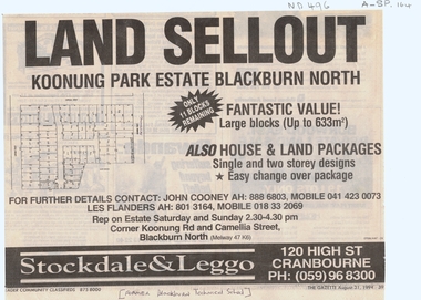 Whitehorse Historical Society Inc.
Article, Land sellout Koonung Park estate, 31/08/1994 12:00:00 AM
... Blackburn Technical School, Koonung Road, Blackburn North.... Mitcham melbourne land subdivision koonung road blackburn north ...Newspaper advertisement for house and land packagesNewspaper advertisement for house and land packages and land sale of Koonung Park Estate on the site of the old Blackburn Technical School, Koonung Road, Blackburn North.Newspaper advertisement for house and land packagesland subdivision, koonung road, blackburn north, blackburn technical school, stockdale & leggo (estate agents), camellia street, lantana street, rigani court, polydor place -
 Whitehorse Historical Society Inc.
Photograph, Deep Creek Road, Mitcham, 1/09/2000 12:00:00 AM
... Black and white photo of View looking North along Deep... North along Deep Creek Road, Mitcham, taken from Car Park ...Black and white photo of View looking North along Deep Creek Road, Mitcham, taken from Car Park of Schwerkolt Cottage and Museum Complex.mitcham