Showing 2304 items matching "parishes"
-
 Linton and District Historical Society Inc
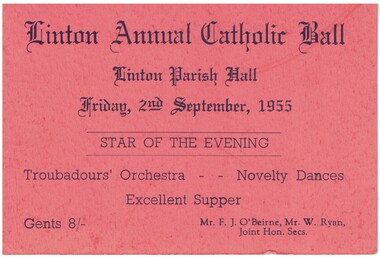
Ticket, Linton Annual Catholic Ball, 1955, 1955
Orange card, black printing. Ticket for Linton Annual Catholic Ball, held 2nd September 1955.Text: " Linton Annual Catholic Ball /Linton Parish Hall / Friday, 2nd September, 1955 / STAR OF THE EVENING. "linton catholic church, events, balls, f. j. o'beirne, w. ryan -
 Bendigo Historical Society Inc.
Map - CAMPBELL COLLECTION: BENDIGO AND DISTRICT MAPS, 22-3-29
Map. Marong, Parishes of Marong, Lockwood and Mandurang, Scale 20 chains to 1 inch, Total area 5106 acres. Crusoe Reservoir & Viaduct and water race. Compiled in W.P.B. fro Field Survey and Parish Plans. B.W.L.22-3-29 (number 389 in map cupboard 1)B.W.L.map, bendigo, allotments -
 Ringwood and District Historical Society
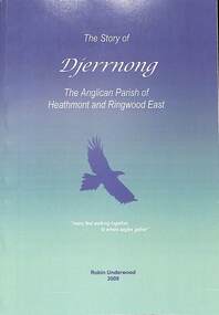
Book, The Story of Djerrnong - The Anglican Parish of Heathmont and Ringwood East, 2009
History of the Anglican Parish of Heathmont and Ringwood East written by Robin Underwood - 105 pages +Additional Keywords: Underwood, Robin -
 Federation University Historical Collection
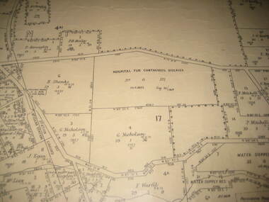
Plan - Plan - Cadastral, Parish of Ballaarat - Sheet 3 (only), 03/03/1932
Sheet 3 of the Parish of Ballart showing Government roads, crown allotments, dimensions, crown grantees, date of grants, etc,ballarat, plan, hospital for contagious diseases, sebastopol, sebastopol rifle range, fiscalini, leigh river, yarrowee creek -
 Bendigo Historical Society Inc.
Map - JACK FLYNN COLLECTION: COUNTY OF GLADSTONE, 1934
Map: County of Gladstone, map sheet showing the whole of the County and the Parishes within. Scale 2 Miles to 1 inch.Engraved at the Department of Lands and Survey Melbourne. 1958. By Authority of W.M. Houston, Government Printermap, gladstone, parish plan, gladstone -
 Bendigo Historical Society Inc.
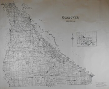
Map - JACK FLYNN COLLECTION: COUNTY OF GUNBOWER, 1935
Map; County of Gunbower. Sheet containing the whole of the County, showing parishes within. Scale 2 Miles to 1 inch.map, gunbower, parish plan, gunbower -
Bendigo Historical Society Inc.
Map - PART PARISHES OF SANDHURST MARONG AND NERRING, No date visible
Map: Section of a Parish plan of Bendigo, covering Ironbark, Eaglehawk and Myers Flat ( number 145 in Map Cupboard 1)map, bendigo, city streets, parish of sandhurst, parish of marong, parish of nerring, ironbark, eaglehawk, myers flat -
Bendigo Historical Society Inc.
Map - BENDIGO IRRIGATION SETTLEMENT, 12/02/1908
Map: Plan of Bendigo Irrigation Settlement, Parishes of Sandhurst and Wellsford, County of Bendigo ( number 160 in Map Cupboard 1)map, bendigo, irrigation settlement, bendigo irrigation settlement, parishes of sandhurst and wellsford, county of bendigo -
Bendigo Historical Society Inc.
Map - TARNAGULLA (PARTS), Circa 1880's
Map: Compilation of 3 hand draughted parish plans showing portions of Tarnagulla (number 261 in map cupboard 1)map, parish plan, tarnagulla -
Bendigo Historical Society Inc.
Map - SANDHURST (PART), Circa 1880's
Map: Parish plan showing the area Specimen Hill Road and Inglewood St. ( number 222 in Map Cupboard 1)map, bendigo, parish plan, specimen hill rd. inglewood st. -
Whitehorse Historical Society Inc.
Document, Crown Portion 119, c1970
Description of transfers of ownership of Crown Portion 119, Parish of Nunawading, 1858 - 1960, bounded by Whitehorse and Mitcham Roads, Mitcham.morgan, robert rowland, the church of england trusts corporation, mitcham, whitehorse road, mitcham, mitcham road, mitcham, peel street, mitcham, ormond avenue, mitcham, edward street, mitcham, christ church anglican church, mitcham, churches -
Whitehorse Historical Society Inc.
Document, Elizabeth Jane Creswell, 1833
Extract from register of Parish Church of Mitcham, County of Surrey.Extract from register of Parish Church of Mitcham, County of Surrey, of baptism of Elizabeth Jane Creswell, 24/11/1833.Extract from register of Parish Church of Mitcham, County of Surrey. pioneers, creswell, elizabeth jane, creswell, william, creswell, sarah, mitcham, surrey, england -
![Parish of Nunawading, County of Bourke showing land acquired under Closer Settlement Acts [C 1887]](/media/collectors/56f368632162f118acbff12e/items/60d923316e5f99545134f182/item-media/6147b12a4806c7ae686c24e4/item-fit-380x285.jpg) Whitehorse Historical Society Inc.
Whitehorse Historical Society Inc.Map, Parish of Nunawading, ca 1887
Parish of Nunawading, County of Bourke showing land acquired under Closer Settlement Acts [C 1887]Parish of Nunawading, County of Bourke showing land acquired under Closer Settlement Acts [C 1887] 1947 reprint.Parish of Nunawading, County of Bourke showing land acquired under Closer Settlement Acts [C 1887] parish of nunawading, box hill, maps, land settlement -
Whitehorse Historical Society Inc.
Document, Title to 59 Mount Pleasant Road Nunawading, 1871 - 1992
Copies of Title documents for Lot 3, Plan of Subdivision 18705 for Section 117b, Parish of Nunawading from 1871 to 1992.Copies of Title documents for Lot 3, Plan of Subdivision 18705 for Section 117b, Parish of Nunawading from 1871 to 1992.Copies of Title documents for Lot 3, Plan of Subdivision 18705 for Section 117b, Parish of Nunawading from 1871 to 1992.mount pleasant road, nunawading no. 59, land titles, jones, dan, jones, anne -
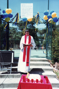 Whitehorse Historical Society Inc.
Photograph, Fr. Kevin Dillon celebrates 40th Birthday of St. John's Catholic Church, Mitcham as a separate Parish, 2/02/1992 12:00:00 AM
Coloured photo of Fr. Kevin Dillon celebrates 40th Birthday of St. John's Catholic Church, Mitcham, as a separate Parish.dillon, kevin joseph, fr., st. john's catholic church, mitcham -
Bendigo Historical Society Inc.
Book - LYDIA CHANCELLOR COLLECTION: HISTORY OF THE PARISH CHURCH OF ST PAUL 'THE FIRST HUNDRED YEARS', 1968
LYDIA CHANCELLOR COLLECTION: HISTORY OF THE PARISH CHURCH OF ST PAUL 'THE FIRST HUNDRED YEARS' plus programmes 1868-1968bendigo, history, bendigo churches -
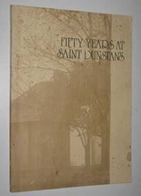 Camberwell Historical Society
Book, Vestry of St. Dunstan's Church of England, Fifty Years at Saint Dunstan's, 1976
A history of the Anglican parish of Saint Dunstan, Camberwell 1926-1976. Published by the Vestry of St Dunstan's Church of England, 1976.camberwell, australia, history, churches -
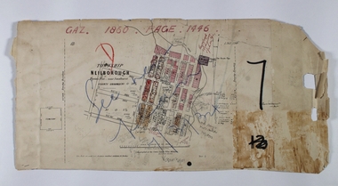 Bendigo Historical Society Inc.
Map - NEILBOROUGH RAVENSWOOD, October 21 1859
Map:Township of Neilborough, Elysian Flat, near Sandhurst,County unnamed. Parish plan. Backing is a part of Ravenswood Township map.map, bendigo, neilborough, elysian flat, ravenswood -
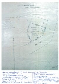 Linton and District Historical Society Inc
Mining survey document, Mining Survey Document, 1890
Document drawn up in relation to an application for a mining lease made by Isaac Walker of Linton. Application no. PP16, Lease no. 1351. Application was made for a mining lease on land in Sussex Street, Linton, which was occupied by Sarah Dawe and family. Original document is held at PROV Ballarat. Item and series details are recorded in handwriting on the lower part of the document.Photocopy of original document, which shows a plan of Allotments 3 & 4, Section 1A, Township of Linton, Parish of Argyle.mining applications, mining leases, plans, documents, isaac walker, dawe family, sarah dawe née carpenter -
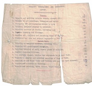 Linton and District Historical Society Inc
Building quote, Church of England Building Renovations and Improvements, Linton
Typed, undated quote for costs of building renovations and improvements to Linton Church of England and parish hall. Builder's name not recorded.Text: " BUILDING RENOVATIONS AND IMPROVEMENTS / LINTON. "st paul's church of england linton, parish hall -
 Bayside Gallery - Bayside City Council Art & Heritage Collection
Map, Department of Crown Lands and Survey, Moorabbin, County of Bourke, c. 1918
The cadastral map of the Parish of Moorabbin in Victoria (L.6104) shows parish boundaries and land ownership c. 1918 when Sandringham was a Borough.moorabbin, county of bourke, map, plan, land subdivision, land titles, foreshores, sndringham, hampton, beaumaris, highett, cheltenham, department of lands and survey, land owners, cartographic material, borough of sandringham, brighton -
Bendigo Historical Society Inc.
Map - CAMPBELL COLLECTION: BENDIGO AND DISTRICT MAPS, 8-6 29
Map. Kimbolton, Parishes of Kimbolton and Lyell, scale 20 chains to 1 inch. Area by Plamimeter 6258 acres. Coliban River, Knowsley, Strathfieldsaye 10 1/2 miles. Prepared in W.P.B. from Parish and Assessor's Plans. G.W.Latimer 8-6-29. (number 393 in map cupboard 1)G.W.Latimermap, bendigo, allotments -
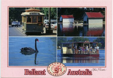 Ballarat Tramway Museum
Postcard, Steve Parish Publishing Pty Ltd, "Ballarat Australia" and "Victoria Collection", 2003
Printed full colour postcard titled "Ballarat Australia" and "Victoria Collection". Features photos of BTM No. 27, Lake Wendouree, black swan and paddle board. On rear is places for correspondence, stamp, barcode, address and publisher logo. Has the name of the publisher "Steve Parish" Steve Parish No. PC3036 and address details. trams, tramways, btm, wendouree parade, gardens, lake wendouree, swans -
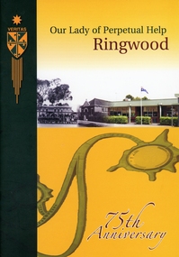 Ringwood and District Historical Society
Book, "Our Lady of Perpetual Help Ringwood" History Book, 2005
Book produced for the 75th anniversary of the Parish and school. List of Principals, list of Parish Priests. The school was built in 1932 on what had been an orchard.Yellow and black covered book with photos of church on front and schoolchildren on back. 46 pages of text and photos, no index. +Additional Keywords: Lacey, Angela / Tien, Joe Bui DucCelebrating 75 years of history at Our Lady of Perpetual Help School in Wilana Street, Ringwood -
 Bacchus Marsh & District Historical Society
Map, Balliang Parish Map, County of Grant c.1907
A single page paper map showing parish plan map for Balliang. This parish area contains the localities of Balliang and Balliang East and is located south of the township of Bacchus Marsh. The map is pasted into a bound volume containing 76 maps or plans in total. High resolution digital image stored on BMDHS computer network. balliang victoria maps, balliang parish maps -
Glen Eira Historical Society
Drawing - St. Agnes Church, Booran Road, 116, Glen Huntly
A 105 Committee pamphlet giving thumbnail sketch of parish and the reasons why the 105 committee was formed for the church repair program and renovation for the growing parish community.st. agnes’ church, glen huntly, booran road, wright nigel father, barren john, britton cath, cheshire jean, jennings phil, lusk gary, tomlinson mac, agg val, clarke wilf, young george, architectural features, stanistreet john, timber, foundation stores -
Bendigo Historical Society Inc.
Map - CAMPBELL COLLECTION: BENDIGO AND DISTRICT MAPS
Map. Sedgwick. Parishes of Strathfieldsaye, Lyell and Sedgwick. Scale 20 chains to 1 inch. (number 359 in map cupboard 1)map, bendigo, agricultural lands -
Bendigo Historical Society Inc.
Map - CAMPBELL COLLECTION: BENDIGO AND DISTRICT MAPS
Map. Lyell, Parishes of Sedgwick, Eppalock and Lyell. Scale 20 chains to 1 inch. (number 348 in map cupboard 1)map, bendigo, agricultural lands -
Port Melbourne Historical & Preservation Society
Booklet - Carmelite Parish newsletter, "The Carmelite" 7 October 2018, 2018 - 2019
These items were collected by a PMHPS member during 2018-19 and they have been retained as a group of ephemeraVarious ephemera of local interest showing changes in community. .01 The Carmelite Parish newsletter booklet dated 7 October 2018religion - roman catholic church (st josephs), parish of port melbourne -
Bendigo Historical Society Inc.
Map - PART PARISHES OF MANDURANG AND SANDHURST, No date visible
Map: Section of Parish plan of Bendigo covering Mandurang, Diamond Hill, and Quarry Hill, ( number 147 in Map Cupboard 1).Map 11map, bendigo, city streets, parish of mandurang, parish of sandhurst, diamond hill , quarry hill