Showing 10956 items matching "plenty"
-
 Eltham District Historical Society Inc
Slide - Photograph, Main Yarra Trail, Lower Plenty, c.Aug. 1990
Part of a presentation, "Roads and Byways of the Shire of Eltham", by Russell Yeoman to the 12 September 1990 Society meeting. Slides shown included copies of old photos and recent images ranging from the suburban streets of Eltham and Montmorency to the mountain roads of Kinglake. In the byways category are views of some iof the Shire's bicycle paths including then recently completed sections of the Main Yarra Trail at Lower Plenty.35mm colour positive transparency (1 of 37) Mount - Agfachrome Agfa CS System black 8 dotsinfrastructure, bonds road, lower plenty, roads -
 Eltham District Historical Society Inc
Slide - Photograph, Main Road, Lower Plenty, c.Aug. 1990
Part of a presentation, "Roads and Byways of the Shire of Eltham", by Russell Yeoman to the 12 September 1990 Society meeting. Slides shown included copies of old photos and recent images ranging from the suburban streets of Eltham and Montmorency to the mountain roads of Kinglake. In the byways category are views of some iof the Shire's bicycle paths including then recently completed sections of the Main Yarra Trail at Lower Plenty.35mm colour positive transparency (1 of 37) Mount - Agfachrome Agfa CS System black 8 dotsinfrastructure, lower plenty, roads, edward willis court, main road -
 Greensborough Historical Society
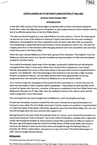
Article, Norm Colvin, Events leading up to the Plenty Ladies' Petition 1842, 2020_
This article, written and researched by Norm Colvin, GHS Secretary, identifies the people involved in the events leading to the petition to the Governor of Victoria, C. J. La Trobe, from 'Ladies resident on Plenty River' requesting protection from bushrangers, 5 May 1842. It identifies the bushrangers, the owners of the stations robbed, the group of men who rode out to assist and the identity of the "ladies" who signed the petition.This article identifies the people involved in the incidents, a list of locals in the 1840s.12 pages typescript, map.plenty river, bushrangers, petitions -
![Article, Greensborough RSL, Memorabilia: Did You Know [Article on water powered flour mills], 1842o](/media/collectors/4f729f5697f83e03086015b8/items/5091b7fc2162ef017426bfd2/item-media/509a25b52162ef0d908e9725/item-fit-380x285.jpg) Greensborough Historical Society
Greensborough Historical SocietyArticle, Greensborough RSL, Memorabilia: Did You Know [Article on water powered flour mills], 1842o
Contains a brief history of the various flour mills that existed on the Plenty River upstream from Greensborough and some others in the district.Contains some hard to find information on district flour mills and their fate.A one page article on Plenty River flour mills written by Jim Allen.Niljanefield mill, george coulstock, john brock, peter hurlestone, carome mill, thomas mill, plenty river, yan yean reservoir, boadles mill, marsh farm, diamond creek -
 Eltham District Historical Society Inc
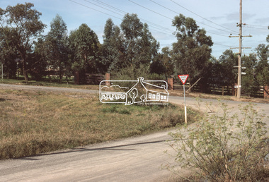
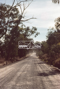
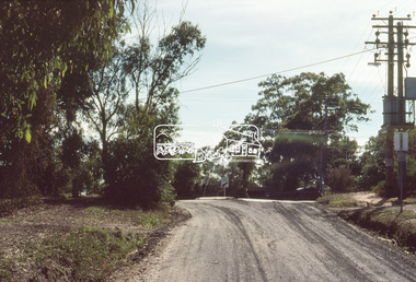
Slide, Bonds Road, Lower Plenty, Mar. 1981
One of a series of images of road infrastructure focussed on Bonds Road, Lower Plenty, the section connecting Old Eltham Road with Rosehill Road, taken by Eltham Shire Council Planning and Engineering officers. They provide perspective of the changes in housing styles and road development that began sweeping in from the mid 1970s with increasing urbanisation of what was once more outlying suburbs and regions. All images have been identified with GPS35 mm colour positive transparency (1 of 13) Mount - Kodak Kodachrome CardProcessed Mar 1981infrastructure, roads, bonds road, lower plenty, old eltham road -
 Eltham District Historical Society Inc
Slide, Bonds Road, Lower Plenty, Mar. 1981
One of a series of images of road infrastructure focussed on Bonds Road, Lower Plenty, the section connecting Old Eltham Road with Rosehill Road, taken by Eltham Shire Council Planning and Engineering officers. They provide perspective of the changes in housing styles and road development that began sweeping in from the mid 1970s with increasing urbanisation of what was once more outlying suburbs and regions. All images have been identified with GPS35 mm colour positive transparency (1 of 13) Mount - Kodak Kodachrome CardProcessed Mar 1981infrastructure, roads, bonds road, lower plenty -
 Eltham District Historical Society Inc
Slide, Bonds Road, Lower Plenty, Mar. 1981
One of a series of images of road infrastructure focussed on Bonds Road, Lower Plenty, the section connecting Old Eltham Road with Rosehill Road, taken by Eltham Shire Council Planning and Engineering officers. They provide perspective of the changes in housing styles and road development that began sweeping in from the mid 1970s with increasing urbanisation of what was once more outlying suburbs and regions. All images have been identified with GPS35 mm colour positive transparency (1 of 13) Mount - Kodak Kodachrome CardProcessed Mar 1981infrastructure, roads, bonds road, lower plenty, rosehill road -
 Eltham District Historical Society Inc
Slide, Bonds Road, Lower Plenty, Mar. 1981
One of a series of images of road infrastructure focussed on Bonds Road, Lower Plenty, the section connecting Old Eltham Road with Rosehill Road, taken by Eltham Shire Council Planning and Engineering officers. They provide perspective of the changes in housing styles and road development that began sweeping in from the mid 1970s with increasing urbanisation of what was once more outlying suburbs and regions. All images have been identified with GPS35 mm colour positive transparency (1 of 13) Mount - Kodak Kodachrome CardProcessed Mar 1981infrastructure, roads, bonds road, lower plenty -
 Eltham District Historical Society Inc
Slide, Bonds Road, Lower Plenty, Mar. 1981
One of a series of images of road infrastructure focussed on Bonds Road, Lower Plenty, the section connecting Old Eltham Road with Rosehill Road, taken by Eltham Shire Council Planning and Engineering officers. They provide perspective of the changes in housing styles and road development that began sweeping in from the mid 1970s with increasing urbanisation of what was once more outlying suburbs and regions. All images have been identified with GPS35 mm colour positive transparency (1 of 13) Mount - Kodak Kodachrome CardProcessed Mar 1981infrastructure, roads, bonds road, lower plenty, old eltham road -
 Eltham District Historical Society Inc
Photograph, Odyssey House Victoria, 28 Bonds Road, Lower Plenty, 6 March 1990
Odyssey House drug rehabilitation centre in Bonds Road, Lower Plenty is a distinctive landmark, especially when viewed from across the Yarra at Templestowe. It was built in the 1950’s as a seminary for the Blessed Sacrament Fathers. Because of the poor and circuitous road access, a suspension footbridge was built across the river. As well as providing easy access for the priests residents of Templestowe could attend services at the seminary. The bridge is now part of the Yarra Trails system.Colour photographlower plenty, bonds road, odyssey house -
 Greensborough Historical Society
Article, A Squatter's life on the Plenty River at 'Wanstead' by Anne Paul, 09/04/1837o
The Willis Diary by GHS member Anne Paul is based on A Pioneer Squatter's Life (Item158). The Willis family were early settlers at Lower Plenty, just near where the hotel and old bridge are today. Anne has reviewed and analysed this chapter from Historical Records of Victoria, Vol. 6. The Crown, the land, and the squatter, 1835-1840. She includes further information on the Willis family and photographs of the archaeological dig at the Bridge Inn Hotel Mernda in 2017.Diary of James L Willis from 1837, portraying hardships suffered in the young colony of Victoria.10 pages, text and colour illustrations. Abridged hard copy of item 4491.willis family, plenty river, lower plenty, james willis, bridge inn hotel mernda -
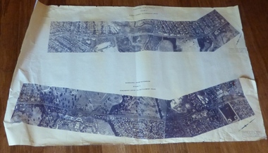
 Eltham District Historical Society Inc
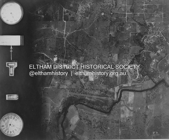
Photograph - Aerial Photograph, Landata, Eltham and Lower Plenty, Nov. 1931
Centred over present-day Rosehill Road and View Road, Lower Plenty Historic Aerial Imagery Source: Landata.vic.gov.au Aerial Photo Details: Project No :1931 Project : MALDON PRISON Run : 19 Frame : 3129 Date : 11/1931 Film Type : B/W Camera : F8 Flying Height : 11000 Scale : 18860 Film Number : 60 GDA2020 : 37°44'16"S, 145°07'40"E MGA2020 : 335039, 5821622 (55) Melways : 21 E11 (ed. 42)aerial photo, eltham, lower plenty, neil webster collection, rosehill road, view road -
 Melbourne Tram Museum
Drawing, Melbourne & Metropolitan Tramways Board (MMTB), Aerial photographs Bundoora Tram Extensions, Plenty Road – MMTB Drawings – 12/1979, Bundoora Extension – Metropolitan Transit Authority – 2/1983, John-Connell – Mott Hay and Anderson – Preliminary drawings for the Latrobe Modal Interchange – August 1984, 1979 to 1984
Set of drawings for the MMTB Plenty Road extension in 1979, MTA extension to Bundoora in 1983 and the Latrobe Uni Modal Interchange - 1984. Large print – Aerial photographs Bundoora Tram Extensions Stage 2 – Albert St to Kingsbury Drive Stage 3 – Kingsbury Drive to Settlement Road Has been rolled, left hand edge damaged, right hand edge torn Compiled by the ROW Division – 2/1981. Has written on rear at right hand end “Bundoora Tram Extension – Official MMTB Plans” 760H x 1190W Plenty Road – MMTB Drawings – 12/1979 P15123 Tyler St to Walsal Avenue P15124 Walsal Ave t McColl St P15125 McColl St to Dorrington Avenue Bundoora Extension – Metropolitan Transit Authority – 2/1983 P15400 Dorrington Avenue to Barwon Avenue P15401 Barwon Avenue to Nicholson Ave P15402 Nicholson St to Barling Park P15403 Barling Park to Darebin Creek P15404 Darebin Creek to Scott Grove P15405 Scott Grove to Clunes Street P15406 Clunes St to Cash St P15408 Cash St to Bundoora Park P15409 Bundoora Park to Larundel Hospital P15410 At Larundel Hospital P15411 Larundel Hospital to Marne Court P15412 Marne Court to Cherrywood Court P15413 Cherrywood Court to Morwell Ave P15414 Morwell Ave to Grimshaw St P15415 Grimshaw St to Nickson Street P15416 Nickson St to McLeans Road John-Connell – Mott Hay and Anderson – Preliminary drawings for the Latrobe Modal Interchange – August 1984. 8094-A-20 Set Out Plan and Paving Details 8094-A-21 Elevations 8094-A-22 Sections 8094-A-23 Roof Plan and Stormwater Layout 8094-A-24 Canopy Details 8094-A-25 Toilet Block and Waiting Room 8094-A-28 Miscellaneous DetailsOn rear of aerial photograph sheet - at right hand end “Bundoora Tram Extension – Official MMTB Plans” in felt pen.trams, tramways, plenty rd, bundoora, latrobe university, mmtb, construction, mta -
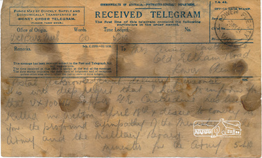 Eltham District Historical Society Inc
Telegram, Telegram, Victoria Barracks, Melbourne to Mrs Annie Castledine, Old Eltham Road, Lower Plenty, 3 May 1941, 3 May 1941
"Postal acknowledgement delivery personal" "It is with deep regret that I have to inform you that VX10044 Sapper G. E. Castledine has been killed in action April 18th & desire to convey to you the profound sympathy of the Minister for the Army and the Military Board. - Minister for the Army" Sapper George Ernest Castledine (1914-1941), son of Arthur Frederick and Annie Castledine, enlisted 23 January 1940 at Lower Plenty and was assigned to the 2/2 Field Company. He is buried in the Phaleron War Cemetery, Athens, Greece and is remembered on the Roll of Honour at Eltham.George was the first soldier from the Shire of Eltham to be killed in the Second World War. The telegram is oil stained as it was kept by George's brother Sid in his toolbox.Digital image of original held in private collection of Joan Castledine (niece of George Ernest Castledine and daughter of Sid and Polly (nee Arrowsmith) Castledine).Original bears oil stains from being stored in a tool box2/2 field company, aif, annie castledine, arthur frederick castledine, eltham war memorial, george ernest castledine, military, minister for the army, roll of honour, second word war, sid castledine, telegram -
 Eltham District Historical Society Inc
Photograph, Looking Back, Looking Forward: Summer Fun in Yarra Plenty exhibition launch, Nillumbik Shire Community Gallery, Eltham Library, 5 December 2019, 5 Dec 2019
Official opening, Thursday 5 December at 2.30pm of exhibition held 5 December 2019 - 6 January 2020 in the Eltham Community Gallery, Eltham Library Eltham District Historical Society is a member of the Yarra Plenty Heritage Group, which together with the Nillumbik U3A Painting and Drawing Group participated in an exhibition of historical photographs and original artworks side by side in a celebration, at the Eltham Library Community Gallery, of all things summer - picnics, swimming, boating, horsing around and enjoying nature with family and friends during long summer days. 56 Born Digital images2nd eltham sea scouts, andrew ross museum, eltham district historical society, eltham library, exhibition, greensborough historical society, heidelberg historical society, museums australia (victoria), nillumbik historical society, nillumbik reconciliation group, nillumbik shire council, nillumbik u3a drawing and painting group, roving curator, st andrews/queenstown historical society, u3a, yarra plenty heritage network, yarra plenty regional library -
 Melbourne Tram Museum
Document, Victorian Parliament, "The Plenty Road, Preston, Tramway Extension Inquiry", 1967
Report by the Victorian Parliamentary Public Works Committee on "The Plenty Road, Preston, Tramway Extension Inquiry" - 1967. The inquiry examined the MMTB's proposal to extend the East Preston line 0.7miles or 1.3km. The Committee took evidence from the MMTB, bus operators, the Victorian Railways, residents, La Trobe University, Preston City Council and others. The Committee recommended against the proposal. The report lists those members of Parliament involved. The line was subsequently extended by 1.2 kilometres from Tyler Street to Boldrewood Parade during 1983 and subsequently to Bundoora. Demonstrates the method of holding parliamentary inquiries into new tram lines.Document - report - 9 pages stapled in top left-hand corner, printed with a spirit duplicator.tramways, parliament, new lines, east preston, inquiries, bundoora, plenty road -
 Eltham District Historical Society Inc
Photograph - Aerial Photograph, Landata, Montmorency / Lower Plenty, Jan. 1973
Centred on 385 Main Road, Lower Plenty bounded by Grand Boulevard, Montmorency to north, Old Eltham Road to south, Bolton Street to east and Panorama Avenue to west. Historic Aerial Imagery Source: Landata.vic.gov.au Aerial Photo Details: Project No :1043 Project : MONTMORENCY Run : 2 Frame : 124 Date : 01/1973 Film Type : B/W Camera : RC8 Flying Height : 2200 Scale : 4000 Film Number : 2722 GDA2020 : 37°43'48"S, 145°07'49"E MGA2020 : 335243, 5822507 (55) Melways : 21 E9 (ed. 42)aerial photo, lower plenty, main road, montmorency, phoebe mason collection, bolton steet, grand boulevard, old eltham road, panorama avenue -
Eltham District Historical Society Inc
Folder, Lois and Geoffrey Loftus-Hills
Lois Loftus-Hills (1927-2006) and her husband Geoffrey were founding members of the Australian Democrats. Lois was the editor of the national Journal. Lois was trained in the field of dietetics and when working at the CSIRO met Geoffrey. They lived at Lower Plenty and were instrumental in establishing a local Neighbourhood House. Lois was a member of EDHS. (NL-170)Folder of information on Geoffrey and Lois Loftus-Hills, Lower Plentylois loftus hills, geoffrey loftus hills -
 Eltham District Historical Society Inc
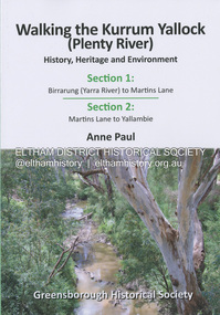
Book, Anne Paul, Walking the Kurrum Yallock (Plenty River), 25 July 2023
Kurrum Yallock - the Plenty River is Melbourne's third river. It is a defining feature of the region weaving its way through local suburbs and parklands. It is often hidden from general view, emerging at bridges and along its extensive trail network. While diminished since European settlement, the River provides an important environmental, wildlife corridor and recreational resource, along with many links to its settlement heritage. The Kurrum Yallock walks aim to guide people along the River Trail, while providing insight into key aspects of our recent history, an opportunity for reflection and an enhanced enjoyment of the River's special environment and landscape.birrarung, greensborough historical society, kurrum yallock, martins lane, plenty river, yallambie, yarra river -
 Eltham District Historical Society Inc
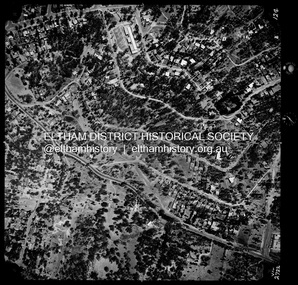
Photograph - Aerial Photograph, Landata, Lower Plenty, Feb. 1956
Centred on present day 217 Old Eltham Road, Lower Plenty bounded by Pitt Street to north, Yarra River to south, Main Road to east and Bonds Road to west. Historic Aerial Imagery Source: Landata.vic.gov.au Aerial Photo Details: Project No :250 Project : MELBOURNE OUTER SUBURBS PROJECT Run : 17 Frame : 116 Date : 02/1956 Film Type : B/W Camera : EAG9 Flying Height : 10000 Scale : 12000 Film Number : 1176 GDA2020 : 37°43'58"S, 145°07'49"E MGA2020 : 335237, 5822186 (55) Melways : 21 E10 (ed. 42)aerial photo, 1956-02, neil webster collection, eltham, main road, bonds road, elham, lower plenty, melway 21e10, pitt street, yarra river -
 Eltham District Historical Society Inc
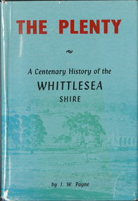
Book, J. W. Payne, The Plenty: A Centenary History of the Whittlesea Shire, 1975
This book traces the one hundered years of the development of the Shire of Whittlesea, from the discovery by Hume and Hovell in 1824 to the time of the centenary in 1975. The intervening years saw the settlement of Vandemonians, Sydney-siders, English, Scots, Irish and Germans, Black Thursday, the building of the Yan Yean Reservoir, the Plenty River flour millls, the timber industry, fruit-growing and export and vineyards. Personalities and pubs, subdivisions, stories of the Findon Hunt Club and various Shires including Epping. History of education and transiton from rural to urban in the south of the Shire. The work is illustrated with maps and photographs. The Shire is now the City of Whittlesea and is an immediate neighbour to the north of the Shire of Nillumbik. shire of whittlesea -
 Eltham District Historical Society Inc
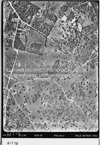
Photograph - Aerial Photograph, Landata, Montmorency / Lower Plenty, 28 Jan. 1946
Centred on 32 Grand Boulevard, Montmorency bounded by Rattray Road to north, Main Road, Lower Plenty to south, Bolton Street to east and Looker Road to west. Historic Aerial Imagery Source: Landata.vic.gov.au Aerial Photo Details: Project No :5 Project : MELBOURNE AND METROPOLITAN AREA PROJECT Run : 34 Frame : 61778 Date : 12/1945 (28.1.46) Film Type : B/W Camera : EAG4 Flying Height : 10200 Scale : 6000 Film Number : 212 GDA2020 : 37°43'30"S, 145°07'37"E MGA2020 : 334934, 5823043 (55) Melways : 21 E8 (ed. 42)aerial photo, bolton steet, looker road, lower plenty, main road, montmorency, phoebe mason collection, rattray road