Showing 8789 items
matching south road
-
 Eltham District Historical Society Inc
Photograph - Aerial Photograph, Landata, Eltham North, Vic, Apr. 1972
... to north, Bellevue Road to south, Zig Zag Road and Beard Street... to north, Bellevue Road to south, Zig Zag Road and Beard Street ...Centred on present day Eltham North reserve near Eltham North Primary School, Eltham North bounded by Allendale Road to north, Bellevue Road to south, Zig Zag Road and Beard Street to east and Ryans Road to west. Historic Aerial Imagery Source: Landata.vic.gov.au Aerial Photo Details: Project No :985 Project : MELBOURNE 1972 Run : 26 Frame : 190 Date : 04/1972 Film Type : B/W Camera : RC10 Flying Height : 5700 Scale : 9600 Film Number : 2636 GDA2020 : 37°41'52"S, 145°08'52"E MGA2020 : 336705, 5826102 (55) Melways : 11 J12 (ed. 42)aerial photo, neil webster collection, 1972-04, allendale road, beard street, bellevue road, eltham, eltham north, eltham north reserve, melway 11j12, ryans road, zig zag road, eltham north primary school -
 Eltham District Historical Society Inc
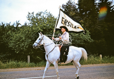
Photograph, Jock Read on 'Popeye', Ersilac Parade, Main Road, Eltham, c.1960, 1960c
... Jock Read riding 'Popeye' south along Main Road approaching... melbourne Jock Read riding 'Popeye' south along Main Road ...Jock Read riding 'Popeye' south along Main Road approaching Bridge Street. Jock acquired 'Popeye' just before the outbreak of WW2. As he was already in the Royal Australian Navy, Jock named the horse after Popeye the Sailor Man. Popeye was a dapple grey, then went white as he aged. Digital file only (Wes's 35mm)don muir collection, eltham, ersilac, ersilac parade, jock read, main road, popeye (horse) -
 Brighton Historical Society
Hat, 1960s
... moved the business to Toorak Road, South Yarra. He continued... at 163 Collins St. He later moved the business to Toorak Road ...Thomas Harrison (1897-1981) was a leading Melbourne milliner from the 1930s. He began his millinery career in 1920, and by the late 1930s had a salon and workshop at 163 Collins St. He later moved the business to Toorak Road, South Yarra. He continued millinery work until 1975.Pink floral dome-shaped hat made up of silk and velvet pink hydrangea petals and mauve silk stems attached to a stiffened net base.Label, printed black on white acetate, centre back: THOMAS HARRISONthomas harrison, hats, 1960s fashion, melbourne fashion -
 Kew Historical Society Inc
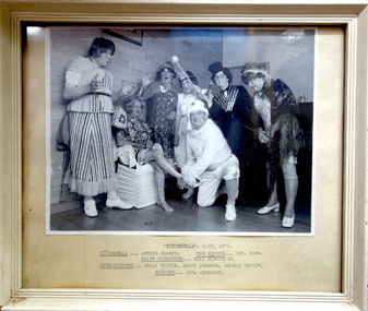
Photograph, Kew Elder Citizens' Club, Cast of 'Cinderella', Kew Elder Citizens' Association, 1976
... established in 1952. During its initial years it met at South Esk... in 1952. During its initial years it met at South Esk in Cotham ...The Kew Elder Citizen's Association was formally established in 1952. During its initial years it met at South Esk in Cotham Road. Later the Club moved to its current headquarters in High Street.Framed photograph of a theatrical performance of 'Cinderella' by the Kew Elder Citizens' Club in 1976. Handwritten insert below photograph: "Cinderella - Cast, 1976 / Arthur Sharpe; The Prince - Hec Camm; Fairy Godmother - Bill Humphries; Step-sisters - Wally Tustin, Ralph Preston, George Driver; Compere - Alma Westcott".kew elder citizens' club -- association, community groups -- kew (vic.), kew senior citizens, theatre -- kew (vic.) -
 Eltham District Historical Society Inc
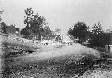
Negative - Photograph, Eltham, Main Road, c.1910
... Eltham, Main Road. Looking south from Henry Street towards... melbourne Eltham, Main Road. Looking south from Henry Street towards ...Eltham, Main Road. Looking south from Henry Street towards Bakery (on left), c.1910 Mrs Davis house on left - Doug Orford recalled that there was always a dog on the couch on the front verandahThis photo forms part of a collection of photographs gathered by the Shire of Eltham for their centenary project book,"Pioneers and Painters: 100 years of the Shire of Eltham" by Alan Marshall (1971). The collection of over 500 images is held in partnership between Eltham District Historical Society and Yarra Plenty Regional Library (Eltham Library) and is now formally known as the 'The Shire of Eltham Pioneers Photograph Collection.' It is significant in being the first community sourced collection representing the places and people of the Shire's first one hundred years.Digital image 4 x 5 inch B&W Neg Print 20 x 25 cmsepp, shire of eltham pioneers photograph collection, eltham, main road, bakery, henry street, mrs davis house -
![Photograph, Charles Ernest Barrie and Jessie May Lang [Barrie], Unknown](/media/collectors/5b29fbbc21ea6714f814b353/items/62e4fd87c63606307f37aabf/item-media/62e4fdebc63606307f37adf4/item-fit-380x285.jpg) Melton City Libraries
Melton City LibrariesPhotograph, Charles Ernest Barrie and Jessie May Lang [Barrie], Unknown
... and Brooklyn road Melton South. ... and Brooklyn road Melton South. Local Identities Black and white ...In 1906 , Jessie May married Charles Ernest Barrie in the Methodist Church Melton on the 23rd August. They lived in the newly built house beside the Chaff Mill on the corner of Station and Brooklyn road Melton South. Black and white photograph of Charles Ernest Barrie and Jessie May Lang [Barrie]local identities -
 Bendigo Historical Society Inc.
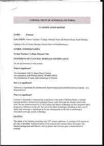
Document - NATIONAL TRUST OF AUSTRALIA(VICTORIA) CLASSIFICATION REPORT, EUMANA
... and Retreat Road, South Bendigo. The association with Cr. James Henry..., Osborne Street and Retreat Road, South Bendigo. The association ...Document, National Trust of Australia (Victoria), Classification Report, Eumana, former Teacher's College, Osborne Street and Retreat Road, South Bendigo. The association with Cr. James Henry Curnow, and William Beebe, JP MBE FRVIA, and the introduction of septic tank technology to Victoria. The house is significant for architectural, historic/social and scientific/technical reasons at a Regional level.National Trust of Australia ( Victoria).document, names of bendigo pioneers, eumana -
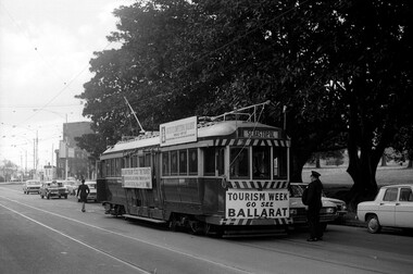 Ballarat Tramway Museum
Photograph - Digital image, Mal Rowe, mid to late Sept. 1971
... Digital image of Ballarat Tram No. 36 in Domain Road, South... Road, South Yarra September 1971 undertaking shuttles between ...Yields information about the operation of Ballarat No. 36 in Melbourne following the closure of the Ballarat system.Digital image of Ballarat Tram No. 36 in Domain Road, South Yarra September 1971 undertaking shuttles between Victoria St and Domain Road for Ballarat Tourism. Driver standing by front of tram with conductress walking to the rear. Behind the tram is the crossover. See also Reg Item 5995 for another Mal Rowe photo of the tram in Swanston St.trams, tramways, ballarat tourism, domain road, tourism, tram 36 -
 Whitehorse Historical Society Inc.
Photograph, Wellington Family
... their residence which adjoined Mr. Wellington's pharmacy. on the south...Whitehorse Historical Society Inc. 2-10 Deep Creek Road ...Black and white photo of Wellington Family. L - R- Judith, Mrs Wellington's Mother, Sue, Keith Wellington, outside their residence which adjoined Mr. Wellington's pharmacy. on the south side of Whitehorse Road between Mitcham, Road and Station Street.wellington, judith, sue, keith pharmacies, wellington pharmacy -
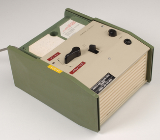 Vision Australia
Equipment - Object, Specto Ltd, Clarke and Smith talking book machine with tapete
... , 31-51 Commercial Road, South Yarra, 3141. Phone: (03) 267..., 31-51 Commercial Road, South Yarra, 3141. Phone: (03) 267 ...In 1965 the Clarke & Smith Talking Book Cassette Cartridge made it's debut at the Olympia Show. Popularly known as a 'tapete', it weighed considerably less than the earlier book cassette cartridges and allowed for up to 6 tracks (13 hours recording time) to be played.Clarke and Smith talking book cassette cartridge player consisting of plastic rectangular case with buttons for navigational controls, light green front and top of machine and darker green on sides, power cord and 5 buttons. Also includes tapete "Words for murder perhaps" by Edward Candy and ready by Stanley Pritchard.Clarke & Smith Track change Play -- Off Volume Phones This equipment remains the property of the Braille & Talking Book Library, 31-51 Commercial Road, South Yarra, 3141. Phone: (03) 267 6022 Dyna Tape labels: J21075 Play Rewindaudio equipment, clarke and smith -
 Eltham District Historical Society Inc
Photograph - Aerial Photograph, Landata, Eltham, Vic, Apr. 1972
... , Eltham bounded by Nyora Road to north, Yarra River to south..., Eltham bounded by Nyora Road to north, Yarra River to south ...Centred on present day Mays Road at Stringybark Road, Eltham bounded by Nyora Road to north, Yarra River to south, Reynolds Road to east and Bible Street to west. Historic Aerial Imagery Source: Landata.vic.gov.au Aerial Photo Details: Project No :985 Project : MELBOURNE 1972 Run : 28 Frame : 209 Date : 04/1972 Film Type : B/W Camera : RC10 Flying Height : 5700 Scale : 9600 Film Number : 2635 GDA2020 : 37°43'33"S, 145°09'28"E MGA2020 : 337647, 5823013 (55) Melways : 22 B8 (ed. 42)aerial photo, neil webster collection, 1972-04, eltham, bible street, mays road, melway 22b8, nyora road, reynolds road, stringybark road, yarra river -
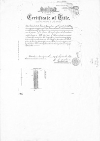 Whitehorse Historical Society Inc.
Administrative record - Document, Certificate of Title, 1/09/1909
... Assets Co Ltd 29 September 1909 for fifty acres fronting on South...Whitehorse Historical Society Inc. 2-10 Deep Creek Road ...Photocopy of Certificate Vol. 3352 Fol 335 to Freehold Assets Co Ltd 29 September 1909 for fifty acres fronting on South Side of Canterbury Road, part Crown Portion 94; including record of subdivision transfers 1909 - 1916 and 1992.land subdivision, .freehold assets company limited, glebe street forest hill, crittle, thomas nathaniel, henwood, william, mcarthur, john, draeger, carl julius otto, jay, daniel, barnes, john thomas, mary ann, kleinert, beatrice annie, stanley ernest -
 Melbourne Tram Museum
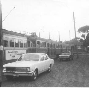
Photograph - Black & White Photograph/s, Ray Jackson, 6/04/1969 12:00:00 AM
... tram on the south of the outside roads at Essendon tram depots...Melbourne Tram Museum 8 Wallen Road Hawthorn melbourne ...Black and White photograph of two W3 class and one W2 class tram on the south of the outside roads at Essendon tram depots with motor vehicles in the view. The front tram has a Lipton's tea advertisement on the side of the tram. Dated 6/4/1969.On rear in ink "April 6th 1969 Essendon Depot"trams, tramways, essendon depot, mmtb, w2 class, w3 class -
 Greensborough Historical Society
Aerial Photograph, AAM Photographics, Heidelberg AAM1969c 106, 24/11/1991
... Plenty River, South boundary Lower Plenty Road....Greensborough Historical Society 34A Glenauburn Road Lower ...One of an overlapping series of aerial photographs of the Heidelberg/Greensborough areas in 1991, covering the Simpson Barracks, Greensborough & Viewbank. North boundary Nell Street, East boundary Plenty River, South boundary Lower Plenty Road.Laminated colour aerial photographsimpson barracks, greensborough, viewbank -
 Bendigo Historical Society Inc.
Document - ROYAL HISTORICAL SOCIETY OF VICTORIA - MEETING MINUTES - 16/02/1985, 16 Feb 1985
... Society of Victoria, 1 City Road, South Melbourne. Apologies... Society of Victoria, 1 City Road, South Melbourne. Apologies ...Document. Four-page copy of the minutes of the quarterly meeting of the State Committee of Member Societies. Meeting held on 16 Feb. 1985 at the headquarters of the Royal Historical Society of Victoria, 1 City Road, South Melbourne. Apologies recorded from Miss F Kingerlee of the Bendigo Branch. On top left of front page handwritten in red biro 'Alec H Stone'.Mr J Irving (Gippsland) Chairmandocument, royal historical society of victoria, meeting minutes, miss f kingerlee, alec h stone. -
 Melbourne Tram Museum
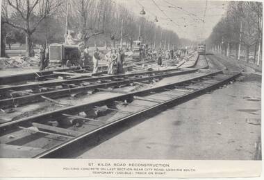
Photograph - Illustration/s, Melbourne & Metropolitan Tramways Board (MMTB), 1950's?
... Road, looking south - temporary (double) track in foreground... Barracks. .3 - "General view from just south of City Road ...Series of three Black and white Illustrations, reproduction of a MMTB report of photographs of the reconstruction of St Kilda Road, near City Road c1955. .1 Photo titled "St Kilda Road Reconstruction Pouring concrete on last section near City Road, looking south. Temporary (double) track on right. Shows a large group of men working, including some looking at the camera. Shows the construction of temporary track. Has a wide bodied W outbound. Has the Shrine of Remembrance in the far distance. .2 - showing "New Work and some temporary work" - shows the "shoo fly" temporary track link between the side temporary track and the new track. Has a tram in the far distance. Photograph taken near Victoria Barracks. .3 - "General view from just south of City Road, looking south - temporary (double) track in foreground. Similar to .l Originally reproduced in a possibly an MMTB report - not a mid 50's annual. Entry revised 7/7/2017 following addition of items .2 and .3trams, tramways, mmtb, st kilda rd, trackwork, reconstruction -
 Eltham District Historical Society Inc
Photograph - Aerial Photograph, Landata, Montmorency, Feb. 1956
... Way to south, Main Road to east and Leach Street to west... Way to south, Main Road to east and Leach Street to west ...Centred on present day Tahlee Place Reserve and Sherbourne Preschool, Montmorency bounded by Progress Road to north, Withers Way to south, Main Road to east and Leach Street to west. Historic Aerial Imagery Source: Landata.vic.gov.au Aerial Photo Details: Project No :250 Project : MELBOURNE OUTER SUBURBS PROJECT Run : 17 Frame : 114 Date : 02/1956 Film Type : B/W Camera : EAG9 Flying Height : 10000 Scale : 12000 Film Number : 1176 GDA2020 : 37°42'50"S, 145°08'02"E MGA2020 : 335512, 5824286 (55) Melways : 21 F5 (ed. 42)aerial photo, 1956-02, neil webster collection, central park, eltham, leach street, main road, melway 21f5, montmorency, progress road, withers way, sherbourne preschool, tahlee place reserve -
 Eltham District Historical Society Inc
Photograph - Aerial Photograph, Landata, Lower Plenty, Feb. 1956
... bounded by Pitt Street to north, Yarra River to south, Main Road... bounded by Pitt Street to north, Yarra River to south, Main Road ...Centred on present day 217 Old Eltham Road, Lower Plenty bounded by Pitt Street to north, Yarra River to south, Main Road to east and Bonds Road to west. Historic Aerial Imagery Source: Landata.vic.gov.au Aerial Photo Details: Project No :250 Project : MELBOURNE OUTER SUBURBS PROJECT Run : 17 Frame : 116 Date : 02/1956 Film Type : B/W Camera : EAG9 Flying Height : 10000 Scale : 12000 Film Number : 1176 GDA2020 : 37°43'58"S, 145°07'49"E MGA2020 : 335237, 5822186 (55) Melways : 21 E10 (ed. 42)aerial photo, 1956-02, neil webster collection, eltham, main road, bonds road, elham, lower plenty, melway 21e10, pitt street, yarra river -
 Eltham District Historical Society Inc
Photograph - Aerial Photograph, Landata, Eltham, Vic, Apr. 1963
... to south, Main Road at Reynolds Road to east and Falkiner Street... to south, Main Road at Reynolds Road to east and Falkiner Street ...Centred on present day Griffith Park Road, Eltham bounded by Mount Pleasant Road to north, Yarra River and Templestowe to south, Main Road at Reynolds Road to east and Falkiner Street to west. Historic Aerial Imagery Source: Landata.vic.gov.au Aerial Photo Details: Project No :486 Project : MELBOURNE (1963) PROJECT Run : 7 Frame : 233 Date : 04/1963 Film Type : B/W Camera : RC8 Flying Height : 5100 Scale : 9600 Film Number : 1805 GDA2020 : 37°44'04"S, 145°09'10"E MGA2020 : 337237, 5822053 (55) Melways : 22 A10 (ed. 42)aerial photo, neil webster collection, 1963-04, eltham, falkiner street, griffith park road, melway 22a10, mount pleasant road, reynolds road, templestowe, yarra river -
 Melbourne Tram Museum
Postcard - Nu-color-Vue - St Kilda Road, Shrine of Remembrance W2 453, Nucolorvue Publishing, 1970s
... Postcard - image looking south in St Kilda Road... Postcard - image looking south in St Kilda Road, with the Shrine ...Postcard - image looking south in St Kilda Road, with the Shrine of Remembrance and BP House in the view. Tram W2 453 (City Route 6) and SW6 945 (Camberwell Route 72) has stopped at the safety zone tram stop.Demonstrates an iconic Melbourne image, St Kilda Road, the Shrine and W class tramsPostcard colour - serrated edge, Nu-color-Vue - St Kilda Road, Shrine of Remembrance W2 453, ML 156, NCV 1381 Divided back.trams, tramways, w2 class tram, shrine of remembrance, tram 453, st kilda road, tram 945 -
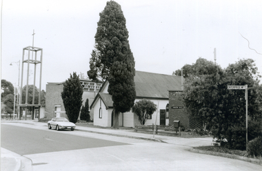 Whitehorse Historical Society Inc.
Photograph, Corner Enterprise Way & Edward Street, Mitcham, 2000
... of Enterprise Way & Edward Street looking South towards Whitehorse Road...Whitehorse Historical Society Inc. 2-10 Deep Creek Road ...Produced as one of a series of 24 prints commissioned by Nunawading & District Historical Society -|Theme: Intersections of Mitcham and Nunawading 2000/2001.|See also Series by P. Simmenauer on the same theme.Black and white photograph - print and negative of corner of Enterprise Way & Edward Street looking South towards Whitehorse Road, Mitcham. L-R: Church Tower [Anglican Church](built circa 1959). Tower surmounts a modern church building in brick and concrete; next door Church Hall 1888 weatherboard construction; Cypress tree; Forster Hall, brick building (circa 1975)forster hall, mitcham, christ church anglican church, church hall -
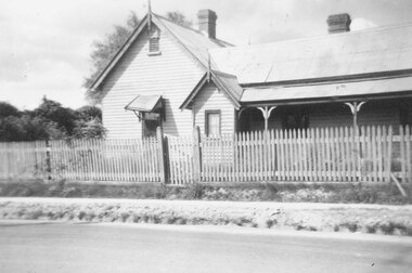 Ringwood and District Historical Society
Photograph, Ringwood State School schoolmaster's residence. 1945
... in Heatherdale Road (Mitcham) south of the railway line to this site... number 2242 in Heatherdale Road (Mitcham) south of the railway ...The residence was relocated from school number 2242 in Heatherdale Road (Mitcham) south of the railway line to this site in Ringwood Street opposite Charter Street where it adjoined the school when it opened at the corner of Maroondah Highway in 1889. For Rear View of the residence see record 6855Written below photograph, "Old schoolmasters residence - Ringwood St. - 1945". Written on back of one of smaller copies, "Was used as a residence by Mr. D. Broben(?) H.? No2977 for many years. Photo taken by Miss Joyce Russell for J. K. McCaskill. Bedford Rd." -
 Bendigo Historical Society Inc.
Map - BENDIGO SHEET 2
... , Grave (Patterson) Street, and the turns at the south end... at the south end of Macdougall Road, the corner of Alder and Aspinal ...Parish map showing the southern section of the City of Bendigo. It shows the city boundary running along Murphy Street, Grave (Patterson) Street, and the turns at the south end of Macdougall Road, the corner of Alder and Aspinal Streets and the corner near the Specimen Hill - Marong roads intersectionH.J. Green Govt. Printer, Melbournemap, bendigo, city streets, city of bendigo, parish map, city boundary -
 Eltham District Historical Society Inc
Photograph, Main Road widening, Eltham, c.March 1968, 1968
... Duplication of Main Road. Looking south from site of Eltham... melbourne Duplication of Main Road. Looking south from site ...Duplication of Main Road. Looking south from site of Eltham Shire offices towards Shillinglaw Cottage. Gahan house to left of Shillinglaw Cottage facing Main Road almost completely demolished. Main Road to the left and the Eltham Tip to the right.Digital file created by stitching two 35mm Colour positive transparency Mount - Agfacolor Service (Blue stepped)duplication, eltham tip, gahan house, main road, shillinglaw cottage -
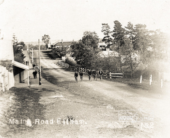
 Eltham District Historical Society Inc
Photograph postcard, Main Road, Eltham; postcard dated 4 November 1909
... Looking south on the Main Road from about opposite Franklin... melbourne Looking south on the Main Road from about opposite ...Looking south on the Main Road from about opposite Franklin Street near the Living and Learning Centre. The Corn Store of W.B. Andrew stood on the south side of the intersection of Franklin Street and Main Road now occupied by Cafe Zen Den.Digital file only Postcards scanned from the collection of Michael Aitken on loan to EDHS, 13 Feb 2018michael aitken collection, postcards, eltham, main road, cafe zen den, corn store, w.b. andrew -
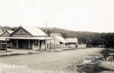
 Eltham District Historical Society Inc
Photograph postcard, Main Road, Eltham
... Looking south on the Main Road from about opposite Franklin... melbourne Looking south on the Main Road from about opposite ...Looking south on the Main Road from about opposite Franklin Street near the Living and Learning Centre. The Corn Store of W.B. Andrew stood on the south side of the intersection of Franklin Street and Main Road now occupied by Cafe Zen Den.Digital file only Postcards scanned from the collection of Michael Aitken on loan to EDHS, 13 Feb 2018michael aitken collection, postcards, eltham, main road -
 Eltham District Historical Society Inc
Photograph - Aerial Photograph, Landata, Eltham, Feb. 1956
... to south, Reynolds Road to east and Central Park to west Historic... to south, Reynolds Road to east and Central Park to west Historic ...Centred on present day Mount Plaeasant Road near Dalton Street, Eltham bounded by Luck Street to north, Eltham Lower Park to south, Reynolds Road to east and Central Park to west Historic Aerial Imagery Source: Landata.vic.gov.au Aerial Photo Details: Project No :250 Project : MELBOURNE OUTER SUBURBS PROJECT Run : 18 Frame : 93 Date : 02/1956 Film Type : B/W Camera : EAG9 Flying Height : 10000 Scale : 12000 Film Number : 1176 GDA2020 : 37°43'02"S, 145°09'38"E MGA2020 : 337871, 5823961 (55) Melways : 22 B6 (ed. 42)aerial photo, 1956-02, neil webster collection, eltham, central park, eltham lower park, luck street, melway 22b6, nyora road, reynolds road, dalton street, mount pleasant road -
 Eltham District Historical Society Inc
Photograph - Aerial Photograph, Landata, Eltham, Vic, Apr. 1963
... and Arthur Street to south, Parsons Road to east and Glen Park Road... and Arthur Street to south, Parsons Road to east and Glen Park Road ...Centred on present day Zig Zag Road and Main Road, Eltham bounded by Maroondah Aqueduct to north, Thompson Crescent and Arthur Street to south, Parsons Road to east and Glen Park Road and Banks Road to west. Historic Aerial Imagery Source: Landata.vic.gov.au Aerial Photo Details: Project No :486 Project : MELBOURNE (1963) PROJECT Run : 5 Frame : 59 Date : 04/1963 Film Type : B/W Camera : RC8 Flying Height : 5100 Scale : 9600 Film Number : 1805 GDA2020 : 37°42'24"S, 145°08'52"E MGA2020 : 336716, 5825114 (55) Melways : 21 J3 (ed. 42)aerial photo, neil webster collection, eltham, 1963-04, arthur street, banks road, glen park road, maroondah aqueduct, melway 21j3, parsons road -
 Eltham District Historical Society Inc
Photograph - Aerial Photograph, Landata, Lower Plenty, Vic, Apr. 1963
... to south, Main Road at Mount Pleasant Road to east and Panorama... to south, Main Road at Mount Pleasant Road to east and Panorama ...Centred on present day Old Eltham Road near Araluen Centre, Lower Plenty bounded by Cromwell Street to north, Yarra River to south, Main Road at Mount Pleasant Road to east and Panorama Avenue to west. Historic Aerial Imagery Source: Landata.vic.gov.au Aerial Photo Details: Project No :486 Project : MELBOURNE (1963) PROJECT Run : 7 Frame : 231 Date : 04/1963 Film Type : B/W Camera : RC8 Flying Height : 5100 Scale : 9600 Film Number : 1805 GDA2020 : 37°44'03"S, 145°07'56"E MGA2020 : 335420, 5822027 (55) Melways : 21 F10 (ed. 42)aerial photo, neil webster collection, 1963-04, araluen, cromwell street, eltham, lower plenty, main road, melway 21f10, mount pleasant road, old eltham road, panorama avenue, yarra river -
 Eltham District Historical Society Inc
Photograph - Aerial Photograph, Landata, Eltham, Vic, Apr. 1963
... to south, Main Road at Kent Hughes Road to east and Bolton Street... to south, Main Road at Kent Hughes Road to east and Bolton Street ...Centred on present day Eltham Lower Park bounded by Brougham Street to north, Yarra River and Fitzsimons Lane Bridge to south, Main Road at Kent Hughes Road to east and Bolton Street to west. Historic Aerial Imagery Source: Landata.vic.gov.au Aerial Photo Details: Project No :486 Project : MELBOURNE (1963) PROJECT Run : 7 Frame : 232 Date : 04/1963 Film Type : B/W Camera : RC8 Flying Height : 5100 Scale : 9600 Film Number : 1805 GDA2020 : 37°44'03"S, 145°08'33"E MGA2020 : 336329, 5822040 (55) Melways : 21 H10 (ed. 42)aerial photo, neil webster collection, 1963-04, bolton steet, brougham steet, eltham, eltham lower park, fitzsimons lane bridge, kent hughes road, melway 21h10, yarra river