Showing 3153 items matching "south west"
-
 Tatura Irrigation & Wartime Camps Museum
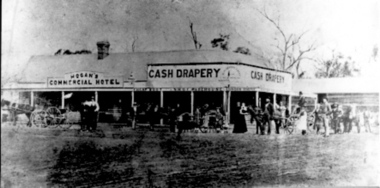
Photograph, Hogan's Commercial Hotel and Cash Drapery
... on the South West corner of Ross and Hogan Streets. Features a number... Drapery Store on the South West corner of Ross and Hogan Streets ...Thomas Hogan's Commercial Hotel and Cash Drapery Store on the South West corner of Ross and Hogan Streets. Features a number of townspeople posing, men, women, workers, and children; three horse drawn buggies. 2 photographs. Original in colour on board; copy black and white.tatura -
 Warrnambool and District Historical Society Inc.
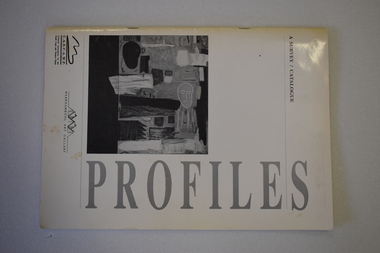
Catalogue, Profiles Warrnambool Gallery, 1994
... (in black and white) by 34 south west Victoria artists...) by 34 south west Victoria artists Profiles Warrnambool Gallery ...This booklet is a catalogue of most of the works of art that were displayed in an exhibition in the Warrnambool Art Gallery in 1994. It was described as ‘a celebration of artists committed to living and working in country Victoria’. It was intended to be the first of similar exhibitions and was initiated by the Warrnambool-based Cultural Association of the South Coast and Western Plains. The Warrnambool Art Gallery was officially opened in 1886 though the local Mechanics’ Institute and Museum had been collecting works of art before this date. When the Mechanics’ Institute building was taken over for Council use in 1963 the Art Gallery ceased to exist and the works put in storage. The Gallery re-opened in temporary premises in 1971 and the present Warrnambool Art Gallery, a memorial to Fletcher Jones, was opened in 1986 in Liebig Street. This is an interesting catalogue as it is one of the few examples we have of the work of the Cultural Association of the South Coast and Western Plains. This Warrnambool-based group operated for a short time only in the 1990s.This is a soft cover booklet of 40 pages. It is bound with metal staples. It has a white cover with black printing and reproductions of black and white works of art on the front and back covers. The booklet contains reproductions of the works of art (in black and white) by 34 south west Victoria artistswarrnambool art gallery, history of warrnambool -
 Flagstaff Hill Maritime Museum and Village
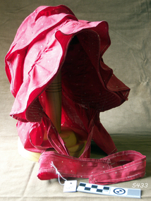
Bonnet, late 19th to early 20th century
... Worn by a local woman when working in South West Victoria... in South West Victoria in the late 1800s - early 1900s flagstaff ...Worn by a local woman when working in South West Victoria in the late 1800s - early 1900sLadies outdoor bonnet, red cotton fabric with white spots. Bonnet is trimmed with frills and straps to tie under the chin. Dated late 19th to early 20th century.flagstaff hill, warrnambool, shipwrecked-coast, flagstaff-hill, flagstaff-hill-maritime-museum, maritime-museum, shipwreck-coast, flagstaff-hill-maritime-village, ladies bonnet, outdoor bonnet, ladies clothing, late 19th century bonnet, 20th century bonnet, bonnet, 20th century, early 20th century bonnet -
 City of Ballarat Libraries
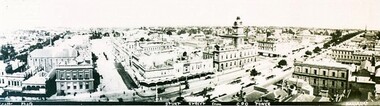
Photograph - Card Box Photographs, Panorama view of Sturt Street, Ballarat circa 1903
... Panoramic view of Sturt Street looking south west... south west. The photo was taken from the G.P.O. tower. Panorama ...Panoramic view of Sturt Street looking south west. The photo was taken from the G.P.O. tower.panorama, sturt street, gpo tower, streetscape, building, public, commerical -
 Clunes Museum
Photograph - PHOTOGRAPHS, VIEW IN TOWNSHIP, CLUNES, SOUTH EAST
... and surrounds; Camp Parade, Clunes South West View in Township, Clunes... of Clunes and surrounds; Camp Parade, Clunes South West View ...Five reproduced black and white images of Clunes and surrounds; Camp Parade, Clunes South West View in Township, Clunes South East Port Phillip and Colonial Goldmining Company Victoria Quartz Mining Company Registered, Clunes Criterion Quartz Mining Company Registered Clunes clunes township, clunes mines -
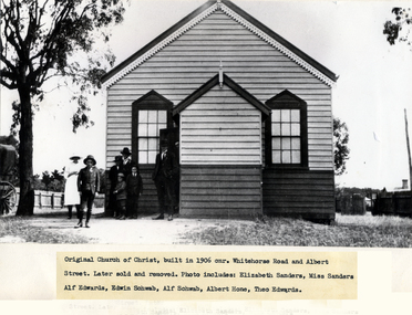 Whitehorse Historical Society Inc.
Photograph - Black & white photo, Church of Christ Blackburn
... in 1906, on South West cnr. Whitehorse Road and Albert Street... of Christ Built in 1906, on South West cnr. Whitehorse Road ...Used by donor in 'Blackburn - a picturesque history'Black & white photo of original Church of Christ Built in 1906, on South West cnr. Whitehorse Road and Albert Street. Later sold and removed..|Photo includes, Elizabeth Sanders, Miss Sanders, Alf Edwards, Edwin Schwab, Alf Schwab,Albert Hone and Theo Edwards.albert street blackburn, whitehorse road blackburn, sanders, elizabeth, miss, edwards, alf, schwab, edwin, hone, albert, theodore, blackburn church of christ -
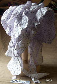 Flagstaff Hill Maritime Museum and Village
Bonnet, late 1800s - early 1900s
... in South West Victoria in the late 1800s - early 1900s... outdoors by women in South West Victoria in the late 1800s - early ...This style of bonnet was commonly worn outdoors by women in South West Victoria in the late 1800s - early 1900sThe bonnet is significant as a typical of women's outdoor headwear in Australia in the late 19th and early 20th century.Ladies outdoor bonnet, white cotton with narrow mauve stripes and small flowers. Bonnet is trimmed with frills and straps to tie under the chin. Dated late 19th to early 20th century.flagstaff hill, warrnambool, shipwrecked-coast, flagstaff-hill, flagstaff-hill-maritime-museum, maritime-museum, shipwreck-coast, flagstaff-hill-maritime-village, ladies bonnet, outdoor bonnet, hat, bonnet, headwear, ladies clothing, late 19th century bonnet, early 20th century bonnet, women's fashion, australian fashion, australian millinery -
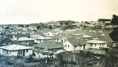 City of Ballarat Libraries
Photograph - Card Box Photographs, View of Sovereign Hill before the development of the historical village circa 1960
... Shows a south west view towards Sovereign Hill before... Ballarat East goldfields Shows a south west view towards Sovereign ...Shows a south west view towards Sovereign Hill before the establishment of the Ballarat Historical Park Association.sovereign hill, private dwellings, landscape, ballarat, mt pleasant -
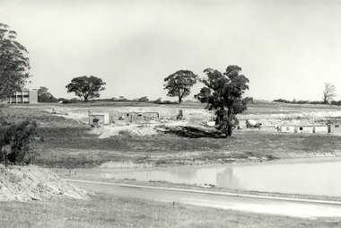 Federation University Historical Collection
Photograph - Black and White, Federation University Albert Coates Complex under construction, 1972
... south west, shows Stage 1 Engineering and Metallurgy/Geology...) View of the first stage residences site south west, shows Stage ...Fiver black and white photographs showing the former Union Building, now the Federation University Albert Coates Complex, under construction. .1) View of the first stage residences site south west, shows Stage 1 Engineering and Metallurgy/Geology. .2) View of the first stage residences site to the South west. Roadway dam creates upper pond. .3) View of the first stage residences site to the eastward. Shows lower pond and roadway dam. .4) View of the first stage residences site to the South. Start of Union Building Construction. .5) .View to the south east across lower pond, shows the Tree of Knowledge and first stage buildings.albert coates complex, union building, mount helen campus -
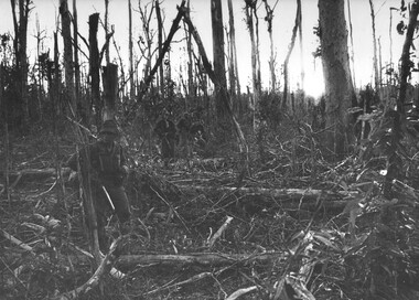 National Vietnam Veterans Museum (NVVM)
Photograph, Gibbons, Denis, Hat Dich Bunker Complex
... in the Hat Dich arae South West of the Australian Task Force Base... arae South West of the Australian Task Force Base at Nui Dat ...Denis Gibbons (1937 – 2011) Trained with the Australian Army, before travelling to Vietnam in January 1966, Denis stayed with the 1st Australian Task Force in Nui Dat working as a photographer. For almost five years Gibbons toured with nine Australian infantry battalions, posting compelling war images from within many combat zones before being flown out in late November 1970 after sustaining injuries. The images held within the National Vietnam Veterans Museum make up the Gibbons Collection. A black and white photograph of diggers from 8th Battalion, Royal Australian Regiment, battle their way through mangled vegetation following massive artillery fire on a bunker complex in the Hat Dich arae South West of the Australian Task Force Base at Nui Dat, Phuoc Tuy Provincephotograph, 8 rar, nui dat, gibbons collection catalogue, 8th battalion, australian task force, phuoc tuy province, hat dich, diggers, denis gibbons -
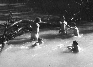 National Vietnam Veterans Museum (NVVM)
Photograph, Gibbons, Denis, Cool Bath
... South West of the Australian Task force at Nui Dat. The Diggers... Australian Regiment enjoy a cool bath during operations South West ...Denis Gibbons (1937 – 2011) Trained with the Australian Army, before travelling to Vietnam in January 1966, Denis stayed with the 1st Australian Task Force in Nui Dat working as a photographer. For almost five years Gibbons toured with nine Australian infantry battalions, posting compelling war images from within many combat zones before being flown out in late November 1970 after sustaining injuries. The images held within the National Vietnam Veterans Museum make up the Gibbons Collection. A black and white photograph of Diggers from 9th Battallion, Royal Australian Regiment enjoy a cool bath during operations South West of the Australian Task force at Nui Dat. The Diggers were allowed, six at a time to complete their ablutions. The battalion had been in the field for three weeksphotograph, 9th battalion, 9 rar, gibbons collection catalogue, australian task force, nui dat, diggers, the royal australian regiment, denis gibbons -
Glenelg Shire Council Cultural Collection
Booklet - Booklet - South Western Victoria, n.d
... of cities and towns in the south west with a short description... of cities and towns in the south west with a short description ...Forty-two page tourist brochure of South Western Victoria, produced by Victorian Railways. Contains black and white photos of cities and towns in the south west with a short description of each. Centre page full colour map of area. Blue cover, red print, image of man in bathers on a beach.Front: 'B.W. Vivian', ink, faded -
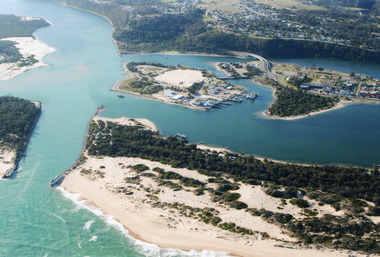 Lakes Entrance Historical Society
Photograph - Lakes Entrance, 2000
... dredge working south west corner of Bullock Island. Lakes... in place, Club Hotel still in situ, small dredge working south west ...Colour photograph aerial view of the entrance, shows entry to North Arm, Cunninghame Arm, Bullock Island, part of Rigby Island, new North Arm Bridge in place, Club Hotel still in situ, small dredge working south west corner of Bullock Island. Lakes Entrance Victoriaislands, waterways, hotels, bridges -
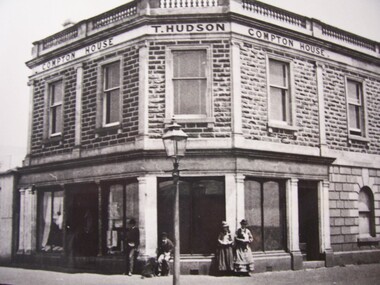 Glenelg Shire Council Cultural Collection
Photograph - Photograph - Compton House, n.d
... Front: Compton House, South West Corner, Percy and Henty... House. Front: Compton House, South West Corner, Percy and Henty ...Displayed at History House.Black and white photograph of Compton House, 3 cornered front, Compton House - T. Hudson - Compton House, written near top of building. Lamp post centre front with two men (one sitting, one leaning) to left, two women (standing) to the right. Stationer Bookseller Shop to one side of Compton House, Brick, timber fence on the other.Front: Compton House, South West Corner, Percy and Henty Streets (typed label). Back: Stamp - State Lib. of S.A. Photographic Section. Reproduction prohibited except withthe permission of the copyright holder. Order No. A/6493 -
 Ringwood and District Historical Society
Photograph, Ringwood Oval, Ringwood Street - circa 1918, 1918
... developed as Eastland carpark, south-west corner.".... ... 1920. (Site) later developed as Eastland carpark, south-west ...Ringwood Oval circa 1920, showing Ringwood Reserve grand stand, tennis courts on the left, and view towards Ringwood Street and Charter Street in the centre backgroun.. The school master's house behind courts was formerly in the Heatherdale Road school in 1885. It was moved in 1892. (See history of Ringwood State School No. 2997).Typed below photograph, "The old Ringwood Reserve grand stand. Tennis courts on the left, looking towards Ringwood and Charter St. in the centre background. ... 1920. (Site) later developed as Eastland carpark, south-west corner." -
 8th/13th Victorian Mounted Rifles Regimental Collection
Flag - Guidon 8th, 1980 circa
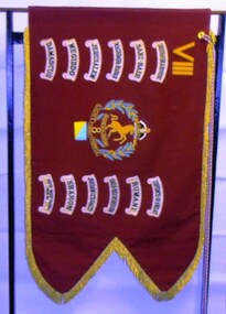
... , Rumani, Gaza-Beersheba, Jordan (Es Salt), Sharon, South West..., South West Pacific 1943-1944" Guidon of the 8th Light Horse ...A guidon is the regimental banner or flag carried by a regiment of light cavalry or light horse. The 8th light Horse (Indi) Regiment was presented with the guidon circa 1927. The actual date is not certain. The guidon carries the battle honours accorded to the regiment for service in the South African War (1899-1902), World War One (!914-1918) and World War Two (1939-1945). The guidon passed into the custody of the 8th/13th Victorian Mounted Rifles Regiment when it was raised on 1 May 1948. At Federation, the Victorian Mounted Rifles companies in North East Victoria were reorganised into the 8th Light Horse Regiment. In 1912 the regiment was renumbered 16th Light Horse. The 8th Light Horse Regiment AIF was raised at Broadmeadows Victoria in September 1914 under the command of Lieutenant Colonel Alexander White and formed part of the 3rd Light Horse Brigade. The regiment served at Gallipoli where in a courageous but ill-fated charge at the Nek on 7 August 1915 it suffered horrendous casualties including Lieutenant Colonel White. Rebuilt in Egypt under the command of Lieutenant Colonel Leslie Maygar VC the regiment went on the serve throughout the Middle East Campaign. Colonel Maygar died of wounds at Beersheba when the regiment was attacked by enemy aircraft while waiting to follow up the successful charge of the 4th LH Brigade on 30 October 1917. The 8th Light Horse AIF was disbanded in 1919, but soon after re-raised as the 8th (Indi) Light Horse in the Citizen Military Forces, superseding 16th (Indi) Light Horse. It had its headquarters at Benalla with sub-units throughout the Upper Murray and Northeast Victoria. In December 1941, the regiment converted from horse to mechanised, initially as 8th Reconnaissance Battalion then in July 1942 it became 8th Cavalry Regiment and served in Northern Territory. As Japanese threat to the mainland declined the regiment was disbanded. In 1948, the 8th Light Horse was linked with 13th and 20th Regiments to form the 8/13 Victorian Mounted Rifles in the Citizen Military Forces. Guidon of the 8th Light Horse Regiment. Maroon corded cotton double thickness fabric with gold metal thread fringe, gold embroidered regimental number in Roman numerals, regimental badge and battle honours; colour patch below badge. Braided corded with tassels.Battle honours: "South Africa 1899-1902, Sari Bair, Maghdaba-Rafah, Jerusalem, Megiddo, Damascus, Defence of ANZAC, Rumani, Gaza-Beersheba, Jordan (Es Salt), Sharon, South West Pacific 1943-1944"guidon, 8th light horse, battle honours -
 Eltham District Historical Society Inc
Negative - Photograph, Russell Yeoman, Kangaroo Ground Presbyterian Church, c.1980
... View from front north side looking south west from cnr... melbourne View from front north side looking south west from cnr ...View from front north side looking south west from cnr of Graham Road and Eltham-Yarra Glen RoadRoll of 35mm colour negative film, 2 strips Kodak Safety 5035 Colour print (x1)Kodak Safety 5035kangaroo ground, church, presbyterian church -
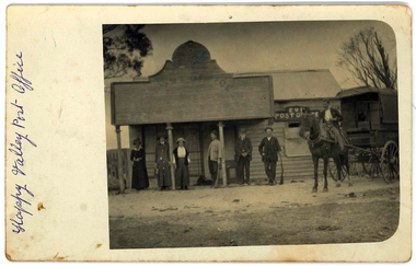 Federation University Historical Collection
Photograph, Happy Valley Post Office, c1905
... . it is a former gold mining town 28 kilometres south-west of Ballarat..... it is a former gold mining town 28 kilometres south-west of Ballarat ...Happy Valley (Victoria) was originally called Lucky Woman's. it is a former gold mining town 28 kilometres south-west of Ballarat.Black and white photo of four men and three women outside the Happy Valley Post Office. One man sits on a horse which stands in front of a carriage. The post office sign includes E.R. - designating Edward VII as the ruling monarch. He sat on the throne from 22 January 1901 to 6 May 1910On front written in ink "Happy Valley Post Office"happy valley, happy valley post office -
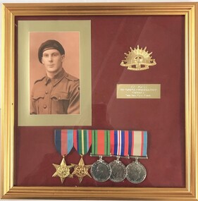 8th/13th Victorian Mounted Rifles Regimental Collection
Medal - Fear 9 Div Cav
... in North Africa, Syria and South West Pacific during World War Two.... in North Africa, Syria and South West Pacific during World War Two ...The 9th Division Cavalry Regiment served with distinction in North Africa, Syria and South West Pacific during World War Two.Framed display of photograph and medals of Trooper George Fear 9th Division Cavalry.VX56755 Tpr George Reginal Fear (Baldy) 9th Div Cav Regtworld war two, wwii, fear, 9 div cav -
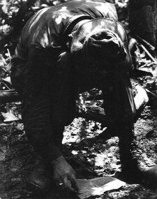 National Vietnam Veterans Museum (NVVM)
Photograph, Gibbons, Denis, Vietnamese Linguist
... in the Hat Dich area, a major NVA/VietCong infiltration route, South.../VietCong infiltration route, South West of the Australian Task ...Denis Gibbons (1937 – 2011) Trained with the Australian Army, before travelling to Vietnam in January 1966, Denis stayed with the 1st Australian Task Force in Nui Dat working as a photographer. For almost five years Gibbons toured with nine Australian infantry battalions, posting compelling war images from within many combat zones before being flown out in late November 1970 after sustaining injuries. The images held within the National Vietnam Veterans Museum make up the Gibbons Collection. A black and white photograph of a digger 'Vietnamese Linguist' attached to 1st Australian Task Force, Nui Dat, Phuoc Tuy Province, studies NVA/VietCong documents captured during a battle in the Hat Dich area, a major NVA/VietCong infiltration route, South West of the Australian Task Force Basephotograph, vietnamese linguist, 1st atf base, nui dat, nva/vc, hat dich, gibbons collection catalogue, australian task force, documents, phuoc tuy province, nva/vietcong, denis gibbons -
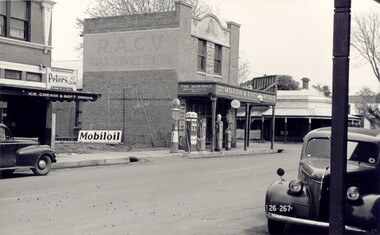 Bacchus Marsh & District Historical Society
Photograph, Simon Brothers Motor Garage corner of Main Street and Grant Street c.1940s
... looking south west towards Grant Street. BMDHS Location: AR/R4/S2... Marsh seen from the northern side of Main Street looking south ...This image shows one of the busiest intersections of Bacchus Marsh, the corner of Main and Grant Streets. The main building shown in the image is Simon Brothers Motor Service and Cycle Depot. In 1903 the Simon brothers, Herbert (Bert) and Walter began making Monarch bicycles and later Monarch motor cycles. In 1913 they moved into newly constructed premises shown in this image. The business operated as both a garage, service station and cycle depot. The business operated until 1948 when P. S. Carey brought the premises to expand his Grant Street car dealership business which was located next to the Simon Brothers garage. Black and white photograph showing Simon Brothers Motor garage Bacchus Marsh seen from the northern side of Main Street looking south west towards Grant Street. BMDHS Location: AR/R4/S2 Photo Album Jack Coe Collection, and digital image on BMDHS computer network.On reverse, "Jack Coe Collection"small businesses bacchus marsh, simon family bacchus marsh, simon brothers garage, petrol stations -
 Port Fairy Historical Society Museum and Archives
Photograph
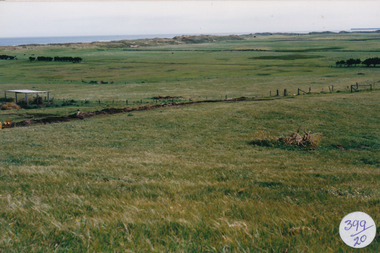
... Street Port Fairy great-ocean-road South Beach Development South ...South Beach DevelopmentColoured photograph of Hills above South Beach Estate looking to seasouth beach, development, west, farmland -
 Port Fairy Historical Society Museum and Archives
Photograph
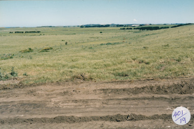
... Street Port Fairy great-ocean-road South Beach Development south ...South Beach Development south beach, development, west, works -
 Melbourne Tram Museum
Ephemera - Tram Route Guides, Public Transport Victoria (PTV), "Tram Route Guide", Oct. 2011 to Oct 2012
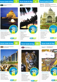
... Route 96 Route 109 Route 112 East Coburg South Melbourne Malvern ...Set of 23 Tram Route Guides, published during 2011 or 2012. Each comprises a vertical DL folded sheet, full colour for the nominated routes, with Yarra Trams, Myki and TramTracker logos, listing the stops, interchanges with bus and other tram services, ticketing zones, estimated frequencies with adverts for Night tram services, TramTracker and Myki tickets. .1 - Route 5 - Melbourne University to Malvern .2 - Route 16 - Melbourne University to Kew .3 - Route 24 and 30 - North Balwyn - Latrobe St and St Vincent's Plaza - Etihad Stadium .4 - Route 48 - North Balwyn - Victoria Harbour Docklands .5 - Route 55 - West Coburg - Domain Interchange .6 - Route 57 - West Maribyrnong to Flinders St Station .7 - Route 59 - Airport West - City .8 - Route 75 - City - Vermont South .9 - Route 78 and 79 - North Richmond - Prahran or St Kilda Beach .10 - Route 82 - Footscray to Moonee Ponds .11 - Route 96 - East Brunswick - St Kilda Beach .12 - ditto .13 - Route 112/11 - West Preston - St Kilda, West Preston - Victoria Harbour Docklands .14 - Route 70 - Wattle Park - Waterfront City Docklands .15 - Route 86/95 - Bundoora - Waterfront City Docklands and Melbourne Museum - City .16 - Route 1 - East Coburg - South Melbourne Beach .17 - Route 3/3a - Melbourne University to East Malvern .18 - Route 6 - Melbourne University to - Glen Iris .19 - Route 8 - Moreland to Toorak .20 - Route 64 - Melbourne University to East Brighton .21 - Route 67 - Melbourne University to Carnegie .22 - Route 72 - Melbourne University to Camberwell .23 - Route 109 - Box Hill - Port Melbourne and Route 31 - Hoddle St - Victoria Harbour - Docklands .24 - Route 75 - Vermont South - dated 10/2011 See Reg Item 2278 for 2016 versionstrams, tramways, timetables, maps, route 1, route 3/3a, route 5, route 6, route 8, route 11, route 16, route 24, route 30, route 31, route 48, route 55, route 57, route 59, route 64, route 67, route 70, route 72, route 75, route 78, route 79, route 82, route 86, route 95, route 96, route 109, route 112, east coburg, south melbourne, malvern, west maribyrnong, airport west, docklands, north balwyn, west coburg, domain interchange, north richmond, prahran, east brunswick, st kilda, vermont south, footscray, moonee ponds, kew, st vincent's plaza, preston, wattle park, bundoora, museum, south melbourne beach, east coburg, east malvern, glen iris, toorak, moreland, east brighton, carnegie, camberwell, box hill, port melbourne -
 Ringwood RSL Sub-Branch
Flag, Japanese flag, WW2
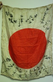
... Captured in the South West Pacific area from surrendered... melbourne Captured in the South West Pacific area from surrendered ...Captured in the South West Pacific area from surrendered Japanese soldiers. Brought home by an Australian soldier and later donated to the Ringwood RSL.Silk with Rising Sun diameter 60cm.Japanese language markings. Also english "Major Watanabe....also Majolleictnant." -
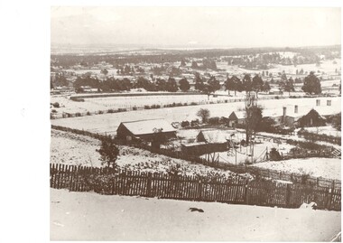 Buninyong & District Historical Society
Photograph - Landscape of part of Buninyong, including Buninyong Boarding School opened in 1848 by Rev Thomas Hastie, Black and white photograph of the Buninyong Boarding School of 1848
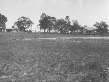
... A winter scene taken looking south-west across Buninyong...A winter scene taken looking south-west across Buninyong ...A winter scene taken looking south-west across Buninyong, and showing the Buninyong Boarding School, opened in 1848 by Rev Thomas HastieGood image with sharp details.buninyong boarding school, uniting church. building styles. education. landscape. -
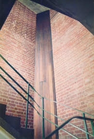 Port Melbourne Historical & Preservation Society
Photograph - Interior tower stairwell, Missions to Seamen, Port Melbourne, Alison Kelly, 1988
... Missions to Seamen, interior tower stairwell, south and west walls... Missions to Seamen, interior tower stairwell, south and west walls ...Photographed by Alison Kelly while she was joint caretaker of the building during the Mission Arts Centre days 1987 to 1991From album of photos mostly by Alison Kelly: Port Melbourne Missions to Seamen, interior tower stairwell, south and west wallsmissions to seamen, built environment, architecture, alison kelly, harry a norris -
 Bacchus Marsh & District Historical Society
Map, Gorrockburkchap Parish Map, County of Grant c.1906
... Gorrockburkghap) lies to the west and south west of the township... Gorrockburkghap) lies to the west and south west of the township ...The parish of Gorrockburkchap (sometimes spelled Gorrockburkghap) lies to the west and south west of the township of Bacchus Marsh. The locality of Rowsley is situated within this parish area.A single page paper map showing the parish plan for Gorrockburkchap in the County of Grant. A cadastral map showing parish boundaries and land ownership The map is pasted into a bound volume containing 76 maps or plans in total. High resolution digital image stored on BMDHS computer network. gorrockburkchap parish maps, rowsley victoria maps, bacchus marsh region parish plans -
 Bacchus Marsh & District Historical Society
Map, Gorrockburkchap Parish Map, County of Grant c.1915
... Gorrockburkghap) lies to the west and south west of the township... Gorrockburkghap) lies to the west and south west of the township ...The parish of Gorrockburkchap (sometimes spelled Gorrockburkghap) lies to the west and south west of the township of Bacchus Marsh. The locality of Rowsley is situated within this parish area.A single page paper map showing the parish plan for Gorrockburkchap in the County of Grant. The map is pasted into a bound volume containing 76 maps or plans in total. High resolution digital image stored on BMDHS computer network. gorrockburkchap parish maps, rowsley victoria maps