Showing 1735 items
matching st kilda street
-
 St Kilda Historical Society
Photograph - Photo map, 11/01/1968
... Carlisle Street St Kilda melbourne One of a series of photo-maps ...One of a series of photo-maps produced for the Department of Crown Lands and Survey (1857-1983). For correlation with a current map, and access to other historical photo maps of Victoria, see the Historic Photo-Maps Index published by the Department of Environment, Land, Water and Planning at https://services.land.vic.gov.au/DELWPmaps/historical-photomaps/Black and white aerial photographVic 2132 State Aerial Survey Melbourne 1968 Proj. Run 27E 11.1.68 5100 ASL 69st kilda, albert park, st kilda east, st kilda beach, alma park, windsor, prahran, 1968 -
 St Kilda Historical Society
Photograph - Photo map, 11/01/1968
... Carlisle Street St Kilda melbourne One of a series of photo-maps ...One of a series of photo-maps produced for the Department of Crown Lands and Survey (1857-1983). For correlation with a current map, and access to other historical photo maps of Victoria, see the Historic Photo-Maps Index published by the Department of Environment, Land, Water and Planning at https://services.land.vic.gov.au/DELWPmaps/historical-photomaps/Black and white aerial photographVic 2132 State Aerial Survey Melbourne 1968 Proj. Run 28E 11.1.68 5100 ASL 81st kilda, balaclava, st kilda east, ripponlea, elwood, elsternwick, caulfield, st kilda botanical gardens, 1968 -
 St Kilda Historical Society
Photograph - Photo map, 11/01/1968
... Carlisle Street St Kilda melbourne One of a series of photo-maps ...One of a series of photo-maps produced for the Department of Crown Lands and Survey (1857-1983). For correlation with a current map, and access to other historical photo maps of Victoria, see the Historic Photo-Maps Index published by the Department of Environment, Land, Water and Planning at https://services.land.vic.gov.au/DELWPmaps/historical-photomaps/Black and white aerial photographVic 2132 State Aerial Survey Melbourne 1968 Proj. Run 29E 11.1.68 5100 ASL 194elwood, elwood beach, elwood park, elsternwick park, ripponlea, elwood canal, balaclava, st kilda, 1968 -
 St Kilda Historical Society
Photograph - Photo map, 11/01/1968
... Carlisle Street St Kilda melbourne One of a series of photo-maps ...One of a series of photo-maps produced for the Department of Crown Lands and Survey (1857-1983). For correlation with a current map, and access to other historical photo maps of Victoria, see the Historic Photo-Maps Index published by the Department of Environment, Land, Water and Planning at https://services.land.vic.gov.au/DELWPmaps/historical-photomaps/Black and white aerial photographVic 2132 State Aerial Survey Melbourne 1968 Proj. Run 27E 11.1.68 5100 ASLst kilda, st kilda west, st kilda pier, catani gardens, st kilda beach, albert park, 1968 -
 St Kilda Historical Society
Photograph - Photo map, 11/01/1968
... Carlisle Street St Kilda melbourne One of a series of photo-maps ...One of a series of photo-maps produced for the Department of Crown Lands and Survey (1857-1983). For correlation with a current map, and access to other historical photo maps of Victoria, see the Historic Photo-Maps Index published by the Department of Environment, Land, Water and Planning at https://services.land.vic.gov.au/DELWPmaps/historical-photomaps/Black and white aerial photographVic 2132 State Aerial Survey Melbourne 1968 Proj. Run 29E 11.1.68 5100 ASL 196elwood, elwood park, elwood canal, elwood beach, st kilda marina, mc moran reserve, point ormond, 1968 -
 St Kilda Historical Society
Photograph - Photo map, Department of Crown Lands and Survey (1857-1983), 22/01/1970
... Carlisle Street St Kilda melbourne One of a series of photo-maps ...One of a series of photo-maps produced for the Department of Crown Lands and Survey (1857-1983). For correlation with a current map, and access to other historical photo maps of Victoria, see the Historic Photo-Maps Index published by the Department of Environment, Land, Water and Planning at https://services.land.vic.gov.au/DELWPmaps/historical-photomaps/Black and white aerial photographVic 2358 Department of Crown Lands and Survey Victoria,.© Melbourne 1970 Project Run 41E 22.1.70 5,100 ASL 62caulfield, caulfield north, st kilda east, armadale, 1970 -
 St Kilda Historical Society
Photograph - Photo map, 14/12/1963
... Carlisle Street St Kilda melbourne One of a series of photo-maps ...One of a series of photo-maps produced for the Department of Crown Lands and Survey (1857-1983). For correlation with a current map, and access to other historical photo maps of Victoria, see the Historic Photo-Maps Index published by the Department of Environment, Land, Water and Planning at https://services.land.vic.gov.au/DELWPmaps/historical-photomaps/Black and white aerial photographVic 1807 Melbourne 1963 Project Run 17 14.12.63 Lens 205 152.70 M/M 5.150 36st kilda, st kilda botanical gardens, balaclava, st kilda east, elwood canal, ripponlea, caulfield north, elwood, caulfield, 1963 -
 St Kilda Historical Society
Photograph - Photo map, Department of Crown Lands and Survey (1857-1983), 22/01/1970
... Carlisle Street St Kilda melbourne One of a series of photo-maps ...One of a series of photo-maps produced for the Department of Crown Lands and Survey (1857-1983). For correlation with a current map, and access to other historical photo maps of Victoria, see the Historic Photo-Maps Index published by the Department of Environment, Land, Water and Planning at https://services.land.vic.gov.au/DELWPmaps/historical-photomaps/Black and white aerial photographVic 2358 Department of Crown Lands and Survey Victoria,.© Melbourne 1970 Project Run 42E 22.1.70 5,100 ASL 77st kilda, st kilda east, st kilda marina, elwood, elwood canal, elsternwick park, point ormond, balaclava, mc moran reserve, ripponlea, st kilda botanical gardens, peanut farm, 1970 -
 St Kilda Historical Society
Photograph - Photo map, Department of Crown Lands and Survey, 22/01/1970
... Carlisle Street St Kilda melbourne One of a series of photo-maps ...One of a series of photo-maps produced for the Department of Crown Lands and Survey (1857-1983). For correlation with a current map, and access to other historical photo maps of Victoria, see the Historic Photo-Maps Index published by the Department of Environment, Land, Water and Planning at https://services.land.vic.gov.au/DELWPmaps/historical-photomaps/Black and white aerial photographVic 2358 Department of Crown Lands and Survey Victoria,.© Melbourne 1970 Project Run 43E 22.1.70 5,100 ASL 208elwood, elwood beach, point ormond, elwood park, elwood canal, mc moran reserve, 1970 -
 St Kilda Historical Society
Photograph - Photo map, Department of Crown Lands and Survey, 22/01/1970
... Carlisle Street St Kilda melbourne One of a series of photo-maps ...One of a series of photo-maps produced for the Department of Crown Lands and Survey (1857-1983). For correlation with a current map, and access to other historical photo maps of Victoria, see the Historic Photo-Maps Index published by the Department of Environment, Land, Water and Planning at https://services.land.vic.gov.au/DELWPmaps/historical-photomaps/Black and white aerial photographCONTROLLED Vic 2358 Department of Crown Lands and Survey Victoria,.© Melbourne 1970 Project Run 41E 22.1.70 5,100 ASL 66st kilda, albert park, st kilda west, catani gardens, st kilda botanical gardens, st kilda pier, st kilda beach, 1970 -
 St Kilda Historical Society
Photograph - Photo map, Department of Crown Lands and Survey, 22/01/1970
... Carlisle Street St Kilda melbourne One of a series of photo-maps ...One of a series of photo-maps produced for the Department of Crown Lands and Survey (1857-1983). For correlation with a current map, and access to other historical photo maps of Victoria, see the Historic Photo-Maps Index published by the Department of Environment, Land, Water and Planning at https://services.land.vic.gov.au/DELWPmaps/historical-photomaps/Black and white aerial photographVic 2358 Department of Crown Lands and Survey Victoria,.© Melbourne 1970 Project Run 42E 22.1.70 5,100 ASL 75st kilda, st kilda beach, st kilda marina, point ormond, st kilda pier, 1970 -
 St Kilda Historical Society
Photograph - Photo map, 14/12/1963
... Carlisle Street St Kilda melbourne One of a series of photo-maps ...One of a series of photo-maps produced for the Department of Crown Lands and Survey (1857-1983). For correlation with a current map, and access to other historical photo maps of Victoria, see the Historic Photo-Maps Index published by the Department of Environment, Land, Water and Planning at https://services.land.vic.gov.au/DELWPmaps/historical-photomaps/Black and white aerial photographVic 1807 Melbourne 1963 Project Run 16 14.12.1963 Lens 205 152.70 M/M 5.150 177st kilda, st kilda pier, catani gardens, middle park, albert park, st kilda west, st kilda beach, 1963 -
 St Kilda Historical Society
Photograph - Photo map, Department of Crown Lands and Survey, 22/01/1970
... Carlisle Street St Kilda melbourne One of a series of photo-maps ...One of a series of photo-maps produced for the Department of Crown Lands and Survey (1857-1983). For correlation with a current map, and access to other historical photo maps of Victoria, see the Historic Photo-Maps Index published by the Department of Environment, Land, Water and Planning at https://services.land.vic.gov.au/DELWPmaps/historical-photomaps/Black and white aerial photographVic 2358 Department of Crown Lands and Survey Victoria,.© Melbourne 1970 Project Run 41E 22.1.70 5,100 ASL 64st kilda, st kilda cemetery, balaclava, st kilda east, windsor, caulfield north, alma park, 1970 -
 St Kilda Historical Society
Photograph - Photo map, Department of Crown Lands and Survey, 08/01/1970
... Carlisle Street St Kilda melbourne One of a series of photo-maps ...One of a series of photo-maps produced for the Department of Crown Lands and Survey (1857-1983). For correlation with a current map, and access to other historical photo maps of Victoria, see the Historic Photo-Maps Index published by the Department of Environment, Land, Water and Planning at https://services.land.vic.gov.au/DELWPmaps/historical-photomaps/Black and white arial photographVic 2345 Department of Crown Lands and Survey Victoria,.© Melbourne 1970 Project Run 40 8.1.70 5,100 ASL 77albert park, fawkner park, south yarra, middle park, prahran, windsor, st kilda, st kilda west, 1970 -
 St Kilda Historical Society
Photograph - Photo map, 22/01/1970
... Carlisle Street St Kilda melbourne One of a series of photo-maps ...One of a series of photo-maps produced for the Department of Crown Lands and Survey (1857-1983). For correlation with a current map, and access to other historical photo maps of Victoria, see the Historic Photo-Maps Index published by the Department of Environment, Land, Water and Planning at https://services.land.vic.gov.au/DELWPmaps/historical-photomaps/Black and white aerial photographVic 2358 Department of Crown Lands and Survey Victoria,.© Melbourne 1970 Project Run 43E 22.1.70 5,100 ASL 206elwood, elsternwick, elsternwick park, 1970 -
 St Kilda Historical Society
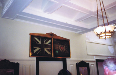
Photograph, St Kilda Town Hall interior - images collection
... Carlisle Street St Kilda melbourne St Kilda St Kilda Town Hall 14th ...colour photographst kilda, st kilda town hall, 14th battalion aif, shiralee saul -
 St Kilda Historical Society
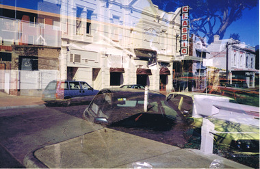
Photograph
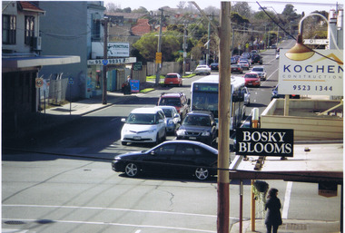
... Carlisle Street St Kilda melbourne Photograph taken from the cafe ...Photograph taken from the cafe on the opposite side of the roadcolour photographelsternwick, classic cinema -
 St Kilda Historical Society
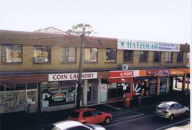
Photograph, Georgia Dimitroulis, 2009
... Carlisle Street St Kilda melbourne Businesses Glen Eira Road ...Colour photograph, mountedI enjoy my school being in Ripponlea because lots of people are caring. Ripponlea has very pretty houses too. Ripponlea also has really green parks which are really good to play in. Ripponlea is a great community to be in because nobody gets left out. By Georgia Dimitroulisbusinesses, glen eira road, ripponlea, ripponlea state school -
 St Kilda Historical Society
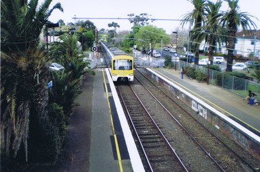
Photograph, Ethan Lawrence, 2009
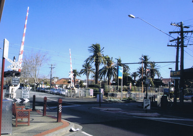
... Carlisle Street St Kilda melbourne Photograph taken in 2009 ...Photograph taken in 2009Colour photograph, mountedI took this picture on the bridge at Ripponlea train station. It shows what the station is like. Two platforms (City, Sandringham) Palm trees that are old and were established with the English people came and settled over Australia. By Ethan Lawrenceripponlea, glen eira road, railway, ripponlea station, ripponlea state school -
 St Kilda Historical Society
Photograph, Tian Steuart
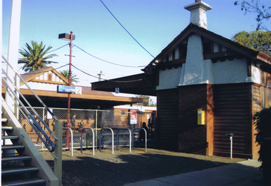
... Carlisle Street St Kilda melbourne Photograph taken in 2009 ...Photograph taken in 2009Colour photograph, mountedI took this photo because I think it represents Ripponlea. The photo shows all of the different things Ripponlea has to offer like beautiful parks with native plants and seating where you can see fascinating views. The station is a great part of Ripponlea because the station is old, interesting and it's good to travel from because it is never busy and it's always very clean. By Tian Steuartripponlea, ripponlea station, ripponlea state school -
 St Kilda Historical Society
Photograph, St Kilda Pier
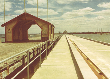
... Carlisle Street St Kilda melbourne The wooden pier was replaced ...The wooden pier was replaced by a reinforced concrete pier in 1970 and the kiosk was relocated. This photograph shows the two piers before the wooden pier was demolished. The concrete pier will be demolished after a new pier, being constructed in 2022-2023, is completed.Colour photographst kilda, st kilda pier, 1970 -
 St Kilda Historical Society
Photograph, St Kilda Park Primary School Tower 2001 - images collection, 27 November 2001
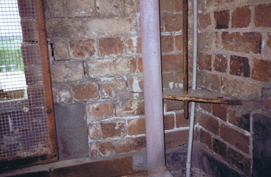
... Carlisle Street St Kilda melbourne The images show maintenance ...The images show maintenance issues at St Kilda Park Primary School in 2001. The school was built in 1879. Former Governor General Sir Zelman Cowen, Archibald Prize-winning artist William Dargie, and test cricketers Bill Ponsford, Keith Miller and Ian Johnson, are among its well known former students.Colour photographsst kilda, st kilda park primary school, fitzroy street -
 St Kilda Historical Society
Photograph, Thalassa Mansion exterior - images collection
... Carlisle Street St Kilda melbourne Images prior to restoration ...Images prior to restoration c2000Images of building at 14/17 Byrne Avenue, Elwood, Victoria before renovation c2000.mansions, byrne avenue, elwood -
 St Kilda Historical Society
Photograph, St Kilda Junction Reconstruction - images collection
... Carlisle Street St Kilda melbourne St Kilda Junction Trams St Kilda ...Colour photographsst kilda junction, trams, st kilda road -
 St Kilda Historical Society
Photograph, Grace Reid, 2009
... Carlisle Street St Kilda melbourne Ripponlea Glen Eira Road ...Colour photograph, mountedripponlea, glen eira road, ripponlea shops, 2009, ripponlea state school -
 St Kilda Historical Society
Photograph, Annabel Ellis, 2009
... Carlisle Street St Kilda melbourne Ripponlea Businesses Ripponlea ...Colour photograph, mountedThis photo shows that not many people want to leave Ripponlea because look at the station, it's almost empty. You can see lots of nature so it's eco-friendly. By Annabel Ellisripponlea, businesses, ripponlea station, ripponlea state school -
 St Kilda Historical Society
Photograph, George Vasko, 2009
... Carlisle Street St Kilda melbourne Ripponlea Glen Eira Road ...Colour photograph, mountedThe special things about Ripponlea is that it is really different to Tasmania because there are a lot more people here because it's very popular. Also there are older buildings in Ripponlea. The best thing about Ripponlea is that it is a new experience for me. By George Vaskoripponlea, glen eira road, ripponlea shops, 2009, ripponlea state school -
 St Kilda Historical Society
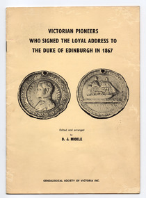
Pamphlet, Genealogical Society of Victoria Inc, Victorian pioneers who signed the loyal address to the Duke of Edinburgh in 1867, 1970
... Carlisle Street St Kilda melbourne A group of 980 colonists who had ...Contents include: Preface, Introductory Note, Port Phillip Pioneers Group, The Address, The Duke's Reply, The Signatories and Dates of Arrival in the ColonyPamphlet of 20 cream coloured pages, printed in black, in yellow coloured cover that is also printed in black. Stapled.non-fictionContents include: Preface, Introductory Note, Port Phillip Pioneers Group, The Address, The Duke's Reply, The Signatories and Dates of Arrival in the Colonyvictoria - history, royal visits, victorian pioneers, prince alfred - duke of edinburgh, 19th century -
 St Kilda Historical Society
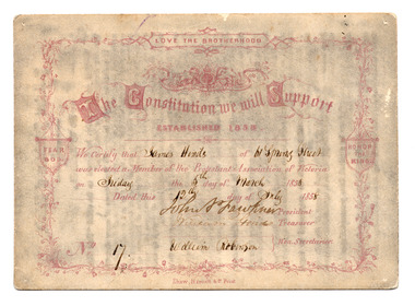
Card - Membership card, Protestant Association of Victoria, The Constitution We Will Support, 1858
... Carlisle Street St Kilda melbourne The Protestant Association ...The Protestant Association of Victoria was established in 1858. It is distinct from the Victorian Protestant Association that was established in 1917 and was active during and after World War I.The card carries the signatures of the founding members of the Association, including John Pascoe Fawkner, who, after settling in Hobson's Bay in October 1835, amassed large land holdings, was a newspaper proprietor and served on the Legislative Council for 18 years. Cream coloured card certifying the membership of James Hinds of 61 Spring Street as Member no. 17 of the Protestant Association of Victoria on 5 March 1958. Printed in dark brown/purple. Handwriting in black ink. Rules printed on the back.James Hinds of 61 Spring Street was elected as Member of the Protestant Association of Victoria on Friday the 5th of March 1958. Dated this 12th day of July 1958. Signatures of John P Fawkner (President), William Hinds (Treasurer), William Robinson (Secretary). No. 17.1858, john pascoe fawkner, 19th century, protestant association of victoria, victoria - history -
 St Kilda Historical Society
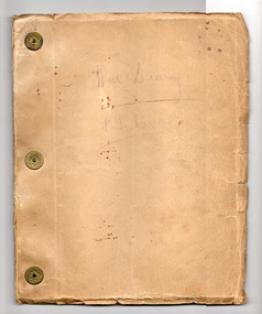
Booklet - Diary, Price, F G, War Diary F. G. Price, 1916-1919
... Carlisle Street St Kilda melbourne Pte Fredrick George Price ...A detailed account of Pte Price's experience of WWI from his embarkation to his return. Sections include: Description of Journey (Arrival at Albany WA; From Albany to Cape Town; Cape Town to Vincent, Verde Island; The Village Blacksmith; Four Days Holiday in London; Back at Camp; Second Visit to London); Review by King George; Zeppelin Air Raids; Embarking for France; The Idea of a Raid; St Omer; Battle of Messines; Bombardment Prior to Advance on Messines; A Visit to France by King George & Prince of Wales; Five Days March from Senlicques; First Battle of Ypres; Preparation for Second Battle of Ypres; 14 Days Leave from France to England; 14 Days Sick Leave62 pages, typewritten, on white paper with a brown paper cover. Bound along one side by 3 brass metal fasteners.non-fictionA detailed account of Pte Price's experience of WWI from his embarkation to his return. Sections include: Description of Journey (Arrival at Albany WA; From Albany to Cape Town; Cape Town to Vincent, Verde Island; The Village Blacksmith; Four Days Holiday in London; Back at Camp; Second Visit to London); Review by King George; Zeppelin Air Raids; Embarking for France; The Idea of a Raid; St Omer; Battle of Messines; Bombardment Prior to Advance on Messines; A Visit to France by King George & Prince of Wales; Five Days March from Senlicques; First Battle of Ypres; Preparation for Second Battle of Ypres; 14 Days Leave from France to England; 14 Days Sick Leavewwi, world war i, f g price