Showing 1378 items matching "state library victoria"
-
 Kew Historical Society Inc
Plan - Subdivision Plan, Forres Estate, East Kew, 1919, 1919
... be found in other collections, such as those of the State Library... be found in other collections, such as those of the State Library ...Pru Sanderson, in her groundbreaking ‘City of Kew Urban Conservation Study : Volume 2 - Development History’ (1988), summarised the periods of urban development and subdivisions of land in Kew. The periods that she identified included 1845-1880, 1880-1893, 1893-1921, 1921-1933, 1933-1943, and Post-War Development. These periods were selected as they represented periods of rapid growth or decline in urban development. An obvious starting point for Sanderson’s groupings involved population growth and the associated economic cycles. These cycles also highlighted urban expansion onto land that was predominantly rural, although in other cases it represented the decline and breakup of large estates. A number of the plans in the Kew Historical Society’s collection can also be found in other collections, such as those of the State Library of Victoria and the Boroondara Library Service. A number are however unique to the collection.Subdivision plans are historically important documents used as evidence of the growth of suburbs in Australia. They frequently provide information about when the land was sold on which a built structure was subsequently constructed as well as evidence relating to surveyors and real estate and financial agents. The numerous subdivision plans in the Kew Historical Society's collection represent working documents, ranging from the initial sketches made in planning a subdivision to printed plans on which auctioneers or agents listed the prices for which individual lots were sold. In a number of cases, the reverse of a subdivision plan in the collection includes a photograph of a house that was also for sale by the agent. These photographs provide significant heritage information relating house design and decoration, fencing and household gardens.An annotated subdivision plan for the Forres Estate, Kew East. The estate was advertised in 1919, the Melbourne Auctioneers being represented locally by Henry Kellett, Estate Agent of High Street, Kew. The name of the estate was derived from the mansion (demolished 2016) of the same name in Normanby Road, which was at one stage owned by the Mayor of Kew, Cr. J. S. Were.subdivision plans - kew, forres estate, argyle road, simpson street, hubert street, normanby road -
 Kew Historical Society Inc
Plan - Subdivision Plan, St Helliers Estate, Kew, circa 1910, c.1910
... be found in other collections, such as those of the State Library... be found in other collections, such as those of the State Library ...Pru Sanderson, in her groundbreaking ‘City of Kew Urban Conservation Study : Volume 2 - Development History’ (1988), summarised the periods of urban development and subdivisions of land in Kew. The periods that she identified included 1845-1880, 1880-1893, 1893-1921, 1921-1933, 1933-1943, and Post-War Development. These periods were selected as they represented periods of rapid growth or decline in urban development. An obvious starting point for Sanderson’s groupings involved population growth and the associated economic cycles. These cycles also highlighted urban expansion onto land that was predominantly rural, although in other cases it represented the decline and breakup of large estates. A number of the plans in the Kew Historical Society’s collection can also be found in other collections, such as those of the State Library of Victoria and the Boroondara Library Service. A number are however unique to the collection.Subdivision plans are historically important documents used as evidence of the growth of suburbs in Australia. They frequently provide information about when the land was sold on which a built structure was subsequently constructed as well as evidence relating to surveyors and real estate and financial agents. The numerous subdivision plans in the Kew Historical Society's collection represent working documents, ranging from the initial sketches made in planning a subdivision to printed plans on which auctioneers or agents listed the prices for which individual lots were sold. In a number of cases, the reverse of a subdivision plan in the collection includes a photograph of a house that was also for sale by the agent. These photographs provide significant heritage information relating house design and decoration, fencing and household gardens.In the subdivision of part of Crown Portion 82, bordered by John and Sackville Streets and Cotham and Burke Roads, over 100 lots were offered for sale. In addition to the designated lots, a number of key locations are also identified. These include the Genazzano Convent to the north of Cotham Road, the Reservoir, St Hilary’s and the land holding of Colonel Parnell on the corner of John Street and Cotham Road. On the Plan, No. 5064, is the handwritten name ‘St. Hellier’s Estate’. St. Helliers, the home of the Dumaresq family is shown beside St. Hilary’s.subdivision plans - kew, st helliers estate -
 Kew Historical Society Inc
Plan - Subdivision Plan, Rimington Nursery Estate, 1949
... be found in other collections, such as those of the State Library... be found in other collections, such as those of the State Library ...Pru Sanderson, in her groundbreaking ‘City of Kew Urban Conservation Study : Volume 2 - Development History’ (1988), summarised the periods of urban development and subdivisions of land in Kew. The periods that she identified included 1845-1880, 1880-1893, 1893-1921, 1921-1933, 1933-1943, and Post-War Development. These periods were selected as they represented periods of rapid growth or decline in urban development. An obvious starting point for Sanderson’s groupings involved population growth and the associated economic cycles. These cycles also highlighted urban expansion onto land that was predominantly rural, although in other cases it represented the decline and breakup of large estates. A number of the plans in the Kew Historical Society’s collection can also be found in other collections, such as those of the State Library of Victoria and the Boroondara Library Service. A number are however unique to the collection.The Kew Historical Society collection includes almost 100 subdivision plans pertaining to suburbs of the City of Melbourne. Most of these are of Kew, Kew East or Studley Park, although a smaller number are plans of Camberwell, Deepdene, Balwyn and Hawthorn. It is believed that the majority of the plans were gifted to the Society by persons connected with the real estate firm - J. R. Mathers and McMillan, 136 Cotham Road, Kew. The Plans in the collection are rarely in pristine form, being working plans on which the agent would write notes and record lots sold and the prices of these. The subdivision plans are historically significant examples of the growth of urban Melbourne from the beginning of the 20th Century up until the 1980s. A number of the plans are double-sided and often include a photograph on the reverse. A number of the latter are by noted photographers such as J.E. Barnes.The house lots in the Rimington Nursery Estate were advertised for sale on Saturday 22nd October 1949. The nine lots in the sale were in Stoke Avenue and Burke Road. Mathers & McMillan of 136 Cotham Road, Kew, offered the lots for sale. [The final sale of lots within the Rimington Nursery Estate occurred as late as 1958.]subdivision plans - kew, rimington nursery estate, monist victor road - kew (vic.) -
 Kew Historical Society Inc
Plan - Subdivision Plan, Erin Heights Estate, East kew, 1917
... be found in other collections, such as those of the State Library... be found in other collections, such as those of the State Library ...Pru Sanderson, in her groundbreaking ‘City of Kew Urban Conservation Study : Volume 2 - Development History’ (1988), summarised the periods of urban development and subdivisions of land in Kew. The periods that she identified included 1845-1880, 1880-1893, 1893-1921, 1921-1933, 1933-1943, and Post-War Development. These periods were selected as they represented periods of rapid growth or decline in urban development. An obvious starting point for Sanderson’s groupings involved population growth and the associated economic cycles. These cycles also highlighted urban expansion onto land that was predominantly rural, although in other cases it represented the decline and breakup of large estates. A number of the plans in the Kew Historical Society’s collection can also be found in other collections, such as those of the State Library of Victoria and the Boroondara Library Service. A number are however unique to the collection.The Kew Historical Society collection includes almost 100 subdivision plans pertaining to suburbs of the City of Melbourne. Most of these are of Kew, Kew East or Studley Park, although a smaller number are plans of Camberwell, Deepdene, Balwyn and Hawthorn. It is believed that the majority of the plans were gifted to the Society by persons connected with the real estate firm - J. R. Mathers and McMillan, 136 Cotham Road, Kew. The Plans in the collection are rarely in pristine form, being working plans on which the agent would write notes and record lots sold and the prices of these. The subdivision plans are historically significant examples of the growth of urban Melbourne from the beginning of the 20th Century up until the 1980s. A number of the plans are double-sided and often include a photograph on the reverse. A number of the latter are by noted photographers such as J.E. Barnes.The Erin Heights Estate in Kew included just seven lots in in Valerie Street. These were all that remained of this wartime subdivision, the other 11 allotments on Balfour and Belford Roads having already been sold. Balfour Road was to be only a temporary name as the street is currently called Windella Avenue. Now, the parkland opposite the subdivision is the reserve created from the route of the Outer Circle Railway. This Railway reached Kew East in 1925, but had been planned as far back as 1873. The development focuses on the benefits of living in Kew: being at the highest of Kew’s ‘suburbs’; being a good residential area; its rapid growth; and the proximity of the Kew East tram in High Street. In 1917, the electric tramline only extended to a terminus at the Harp of Erin hotel. The terminus is clearly represented on the plan.subdivision plans - east kew, erin heights estate -
 Kew Historical Society Inc
Plan - Subdivision Plan, J R Mathers & McMillan, Willsmere Park Estate, c.1940
... be found in other collections, such as those of the State Library... be found in other collections, such as those of the State Library ...Pru Sanderson, in her groundbreaking ‘City of Kew Urban Conservation Study : Volume 2 - Development History’ (1988), summarised the periods of urban development and subdivisions of land in Kew. The periods that she identified included 1845-1880, 1880-1893, 1893-1921, 1921-1933, 1933-1943, and Post-War Development. These periods were selected as they represented periods of rapid growth or decline in urban development. An obvious starting point for Sanderson’s groupings involved population growth and the associated economic cycles. These cycles also highlighted urban expansion onto land that was predominantly rural, although in other cases it represented the decline and breakup of large estates. A number of the plans in the Kew Historical Society’s collection can also be found in other collections, such as those of the State Library of Victoria and the Boroondara Library Service. A number are however unique to the collection.The Kew Historical Society collection includes almost 100 subdivision plans pertaining to suburbs of the City of Melbourne. Most of these are of Kew, Kew East or Studley Park, although a smaller number are plans of Camberwell, Deepdene, Balwyn and Hawthorn. It is believed that the majority of the plans were gifted to the Society by persons connected with the real estate firm - J. R. Mathers and McMillan, 136 Cotham Road, Kew. The Plans in the collection are rarely in pristine form, being working plans on which the agent would write notes and record lots sold and the prices of these. The subdivision plans are historically significant examples of the growth of urban Melbourne from the beginning of the 20th Century up until the 1980s. A number of the plans are double-sided and often include a photograph on the reverse. A number of the latter are by noted photographers such as J.E. Barnes. In 1910, the Willsmere Park Estate Dairy was lauded in the Box Hill Reporter as ‘an object lesson in dairying’. Ten years later, in 1923, it was to be sold. The first subdivision of the Estate included 77 grand allotments with frontages to Belford and Kilby Roads, Elm and Willow Groves, and Acacia Avenue. Every lot was claimed to be ‘high and dry’, and with panoramic views of Kew and East Kew. The balance of the Estate, and the largest proportion of allotments was to be subdivided and sold from 1940. This second sale included 109 lots fronting Kilby Road and Elm and Willow Groves. Annotations on the plan indicate that the more expensive lots faced Belford Road opposite the Kew Golf Links. Two of these sold for £310. Lots further to the west in Willow Grove were sold for £60 less. Many of the houses to be built on these 109 allotments after the War faced Government restrictions on building materials and the dimensions of each house due to postwar shortages.subdivision plans - east kew, willsmere park estate -
 Kew Historical Society Inc
Plan - Subdivision Plan, Jas R Mathers Son & McMillan, East Kew Tramway Estate, 1915
... be found in other collections, such as those of the State Library... be found in other collections, such as those of the State Library ...Pru Sanderson, in her groundbreaking ‘City of Kew Urban Conservation Study : Volume 2 - Development History’ (1988), summarised the periods of urban development and subdivisions of land in Kew. The periods that she identified included 1845-1880, 1880-1893, 1893-1921, 1921-1933, 1933-1943, and Post-War Development. These periods were selected as they represented periods of rapid growth or decline in urban development. An obvious starting point for Sanderson’s groupings involved population growth and the associated economic cycles. These cycles also highlighted urban expansion onto land that was predominantly rural, although in other cases it represented the decline and breakup of large estates. A number of the plans in the Kew Historical Society’s collection can also be found in other collections, such as those of the State Library of Victoria and the Boroondara Library Service. A number are however unique to the collection.The Kew Historical Society collection includes almost 100 subdivision plans pertaining to suburbs of the City of Melbourne. Most of these are of Kew, Kew East or Studley Park, although a smaller number are plans of Camberwell, Deepdene, Balwyn and Hawthorn. It is believed that the majority of the plans were gifted to the Society by persons connected with the real estate firm - J. R. Mathers and McMillan, 136 Cotham Road, Kew. The Plans in the collection are rarely in pristine form, being working plans on which the agent would write notes and record lots sold and the prices of these. The subdivision plans are historically significant examples of the growth of urban Melbourne from the beginning of the 20th Century up until the 1980s. A number of the plans are double-sided and often include a photograph on the reverse. A number of the latter are by noted photographers such as J.E. Barnes.The East Kew Tramway Estate was a subdivision of two separate parcels of land between Adeney Avenue and Normanby Road. The larger section included 54 lots facing Adeney Avenue, Argyle Road, and Campbell, Hunter and Wishart Streets. [Hunter and Wishart Streets were created as part of the subdivision.] A further 17 allotments faced Normanby Road, Hubert and Campbell Streets. [The name of Hubert Street was later to be changed to Cecil Street.] The promotion of the sale referred to the advantages of living between two tram routes, in High Street and Cotham Road. On the plan, quaintly drawn trams mark these routes. Also on the plan is the route of part of the Outer Circle [Railway] Line.east kew tramway estate, subdivision plans - east kew -
 Kew Historical Society Inc
Plan - Subdivision Plan, J R Mathers & McMillan, Clutha Subdivision, 1940
... be found in other collections, such as those of the State Library... be found in other collections, such as those of the State Library ...Pru Sanderson, in her groundbreaking ‘City of Kew Urban Conservation Study : Volume 2 - Development History’ (1988), summarised the periods of urban development and subdivisions of land in Kew. The periods that she identified included 1845-1880, 1880-1893, 1893-1921, 1921-1933, 1933-1943, and Post-War Development. These periods were selected as they represented periods of rapid growth or decline in urban development. An obvious starting point for Sanderson’s groupings involved population growth and the associated economic cycles. These cycles also highlighted urban expansion onto land that was predominantly rural, although in other cases it represented the decline and breakup of large estates. A number of the plans in the Kew Historical Society’s collection can also be found in other collections, such as those of the State Library of Victoria and the Boroondara Library Service. A number are however unique to the collection.The Kew Historical Society collection includes almost 100 subdivision plans pertaining to suburbs of the City of Melbourne. Most of these are of Kew, Kew East or Studley Park, although a smaller number are plans of Camberwell, Deepdene, Balwyn and Hawthorn. It is believed that the majority of the plans were gifted to the Society by persons connected with the real estate firm - J. R. Mathers and McMillan, 136 Cotham Road, Kew. The Plans in the collection are rarely in pristine form, being working plans on which the agent would write notes and record lots sold and the prices of these. The subdivision plans are historically significant examples of the growth of urban Melbourne from the beginning of the 20th Century up until the 1980s. A number of the plans are double-sided and often include a photograph on the reverse. A number of the latter are by noted photographers such as J.E. Barnes.The subdivision plan for the Clutha Subdivision is one of the largest in the Society’s collection. The plan includes a map of the proposed allotments, photographic views to the north and south, and information about the kinds of buildings that could be constructed on the allotments. The subdivision was bounded by Studley Park Road, and Carson, Stevenson and Edgecombe Streets. Two new streets, Mackie Court and Younger Street were created as part of the subdivision. The subdivision took its name from ‘Clutha’, the home of John Carson, who was to become Mayor of Kew in 1863. A Report to the City of Boroondara outlined how: ‘The Clutha estate was progressively developed from 1940, with new houses under construction on the Studley Park Road, Carson and Edgecombe Street frontages by 1941. By 1943, directory listings were available for all addresses with the exception of Mackie Court. Building ceased after the government’s prohibition on civilian building was enforced from 1942, with little change in listings until the 1950s when the remainder of the subdivision was developed’."H"subdivisions - kew - studley park, clutha subdivision, studley park road -
 Kew Historical Society Inc
Plan - Subdivision Plan, Jas R Mathers Son & McMillan, Macartney Estate, East Kew, c. 1925
... be found in other collections, such as those of the State Library... be found in other collections, such as those of the State Library ...Pru Sanderson, in her groundbreaking ‘City of Kew Urban Conservation Study : Volume 2 - Development History’ (1988), summarised the periods of urban development and subdivisions of land in Kew. The periods that she identified included 1845-1880, 1880-1893, 1893-1921, 1921-1933, 1933-1943, and Post-War Development. These periods were selected as they represented periods of rapid growth or decline in urban development. An obvious starting point for Sanderson’s groupings involved population growth and the associated economic cycles. These cycles also highlighted urban expansion onto land that was predominantly rural, although in other cases it represented the decline and breakup of large estates. A number of the plans in the Kew Historical Society’s collection can also be found in other collections, such as those of the State Library of Victoria and the Boroondara Library Service. A number are however unique to the collection.Subdivision plans are historically important documents used as evidence of the growth of suburbs in Australia. They frequently provide information about when the land was sold on which a built structure was subsequently constructed as well as evidence relating to surveyors and real estate and financial agents. The numerous subdivision plans in the Kew Historical Society's collection represent working documents, ranging from the initial sketches made in planning a subdivision to printed plans on which auctioneers or agents listed the prices for which individual lots were sold. In a number of cases, the reverse of a subdivision plan in the collection includes a photograph of a house that was also for sale by the agent. These photographs provide significant heritage information relating house design and decoration, fencing and household gardens.The Macartney Estate subdivision advertised 21 lots for sale on either side of Macartney Street (now Macartney Avenue) and Evans Road in what was then designated as East Kew. Most of the houses shown on the south side of Macartney Street then, as now, have rear entrances on Mount Street, however a number of these blocks have since been further subdivided to allow for the building of new houses on the rear of a block. Brougham Place is marked on the plan but is now called Daniell Place."C"subdivision plans - east kew, macartney estate, macartney street, mount street, evans road, brougham place -
 Kew Historical Society Inc
Plan - Subdivision Plan, J R Mathers & McMillan, Glenarbor Estate, 1934
... be found in other collections, such as those of the State Library... be found in other collections, such as those of the State Library ...Pru Sanderson, in her groundbreaking ‘City of Kew Urban Conservation Study : Volume 2 - Development History’ (1988), summarised the periods of urban development and subdivisions of land in Kew. The periods that she identified included 1845-1880, 1880-1893, 1893-1921, 1921-1933, 1933-1943, and Post-War Development. These periods were selected as they represented periods of rapid growth or decline in urban development. An obvious starting point for Sanderson’s groupings involved population growth and the associated economic cycles. These cycles also highlighted urban expansion onto land that was predominantly rural, although in other cases it represented the decline and breakup of large estates. A number of the plans in the Kew Historical Society’s collection can also be found in other collections, such as those of the State Library of Victoria and the Boroondara Library Service. A number are however unique to the collection.The Kew Historical Society collection includes almost 100 subdivision plans pertaining to suburbs of the City of Melbourne. Most of these are of Kew, Kew East or Studley Park, although a smaller number are plans of Camberwell, Deepdene, Balwyn and Hawthorn. It is believed that the majority of the plans were gifted to the Society by persons connected with the real estate firm - J. R. Mathers and McMillan, 136 Cotham Road, Kew. The Plans in the collection are rarely in pristine form, being working plans on which the agent would write notes and record lots sold and the prices of these. The subdivision plans are historically significant examples of the growth of urban Melbourne from the beginning of the 20th Century up until the 1980s. A number of the plans are double-sided and often include a photograph on the reverse. A number of the latter are by noted photographers such as J.E. Barnes.The little-known Glenarbor Estate comprised 23 allotments bordering Wellington and Denmark Streets and Fenton Avenue. The auction of the allotments in the Estate was held in the Kew Recreation Hall. The purported advantages to Kew are identified on the plan, such as the close proximity of the entrance to the Kew Railway Station and access to shops in Denmark Street. Due to its location, the subdivision was pitched at commercial as well as residential purchasers. The Estate was to cause a crisis in the Kew Council as a majority of councillors voted on 29 May to acquire the entire Estate as the location of a new Town Hall. The Estate was said to be valued at £50,000. A later meeting was to rescind the vote, instead opting for the compulsory acquisition of South Esk on the corner of Charles Street and Cotham Road. That acquisition was to be overturned by the State Government. The debate about the purchase of the Glenarbor Estate by Council coincided with the decision to widen High Street on the South side between Cotham Road and the Junction."D"subdivision plans - kew, glenarbor estate, wellington street, denmark street -
 Kew Historical Society Inc
Plan - Subdivision Plan, Jas R Mathers Son & McMillan, The Dale Estate, Deepdene, 1918
... be found in other collections, such as those of the State Library... be found in other collections, such as those of the State Library ...Pru Sanderson, in her groundbreaking ‘City of Kew Urban Conservation Study : Volume 2 - Development History’ (1988), summarised the periods of urban development and subdivisions of land in Kew. The periods that she identified included 1845-1880, 1880-1893, 1893-1921, 1921-1933, 1933-1943, and Post-War Development. These periods were selected as they represented periods of rapid growth or decline in urban development. An obvious starting point for Sanderson’s groupings involved population growth and the associated economic cycles. These cycles also highlighted urban expansion onto land that was predominantly rural, although in other cases it represented the decline and breakup of large estates. A number of the plans in the Kew Historical Society’s collection can also be found in other collections, such as those of the State Library of Victoria and the Boroondara Library Service. A number are however unique to the collection.The Kew Historical Society collection includes almost 100 subdivision plans pertaining to suburbs of the City of Melbourne. Most of these are of Kew, Kew East or Studley Park, although a smaller number are plans of Camberwell, Deepdene, Balwyn and Hawthorn. It is believed that the majority of the plans were gifted to the Society by persons connected with the real estate firm - J. R. Mathers and McMillan, 136 Cotham Road, Kew. The Plans in the collection are rarely in pristine form, being working plans on which the agent would write notes and record lots sold and the prices of these. The subdivision plans are historically significant examples of the growth of urban Melbourne from the beginning of the 20th Century up until the 1980s. A number of the plans are double-sided and often include a photograph on the reverse. A number of the latter are by noted photographers such as J.E. Barnes.The Dale Estate in Deepdene was made possible by the death of Robert Sparrow Smythe, Australian journalist, newspaper editor/owner and theatrical manager. Smythe lived in his residence ‘Highate’, Deepdene until his death in 1917. In the subdivision proposed one year later, before the end of the First World War, 18 allotments were to be created. The very fragmentary plan in the Society’s collection notes that a large weatherboard [house] will need to be removed. This may be Smythe’s own home. The proposed subdivision included allotments facing Burke and Whitehorse Roads and Dale Street. Bordering the subdivision is the Deepdene Station and the Outer Circle Railway Line. The clear directions on the plan indicate that in 1918 it was possible to travel by train from Deepdene to East Camberwell and Ashburtonsubdivision plans - deepdene, the dale estate -
 Kew Historical Society Inc
Plan - Subdivision Plan, Jas R Mathers Son & McMillan, Clifton Estate, Kew, c. 1916
... be found in other collections, such as those of the State Library... be found in other collections, such as those of the State Library ...Pru Sanderson, in her groundbreaking ‘City of Kew Urban Conservation Study : Volume 2 - Development History’ (1988), summarised the periods of urban development and subdivisions of land in Kew. The periods that she identified included 1845-1880, 1880-1893, 1893-1921, 1921-1933, 1933-1943, and Post-War Development. These periods were selected as they represented periods of rapid growth or decline in urban development. An obvious starting point for Sanderson’s groupings involved population growth and the associated economic cycles. These cycles also highlighted urban expansion onto land that was predominantly rural, although in other cases it represented the decline and breakup of large estates. A number of the plans in the Kew Historical Society’s collection can also be found in other collections, such as those of the State Library of Victoria and the Boroondara Library Service. A number are however unique to the collection.The Kew Historical Society collection includes almost 100 subdivision plans pertaining to suburbs of the City of Melbourne. Most of these are of Kew, Kew East or Studley Park, although a smaller number are plans of Camberwell, Deepdene, Balwyn and Hawthorn. It is believed that the majority of the plans were gifted to the Society by persons connected with the real estate firm - J. R. Mathers and McMillan, 136 Cotham Road, Kew. The Plans in the collection are rarely in pristine form, being working plans on which the agent would write notes and record lots sold and the prices of these. The subdivision plans are historically significant examples of the growth of urban Melbourne from the beginning of the 20th Century up until the 1980s. A number of the plans are double-sided and often include a photograph on the reverse. A number of the latter are by noted photographers such as J.E. Barnes.The Clifton Estate was an ambitious subdivision. It included 61 allotments bordering Cotham and Park Hill Roads, and Florence and Adeney Avenues. It is difficult to ascertain the exact year when the ‘Clifton Estate’ was surveyed, subdivided and first auctioned. The uncertainty may be due to allotments being released during the First World War. The subdivision took its name from the house ‘Clifton’ (lot 5) on the corner of Adeney Avenue and Cotham Road. The outline of Clifton (since demolished) and the extent of its land following the subdivision are represented on the plan. The auctioneers have also shown ‘Maryfield’ and ‘Wimba’, the neighbouring properties in Cotham Road, on the plan."B"subdivision plans - kew, clifton estate, cotham road, adeney avenue, florence avenue, park hill road -
 Kew Historical Society Inc
Plan - Subdivision Plan, Plan of Subdivision of Part of Crown Portion 84 / Parish of Boroondara / County of Bourke / Lodged Plan No. 2217, Twentieth Century
... be found in other collections, such as those of the State Library... be found in other collections, such as those of the State Library ...Pru Sanderson, in her groundbreaking ‘City of Kew Urban Conservation Study : Volume 2 - Development History’ (1988), summarised the periods of urban development and subdivisions of land in Kew. The periods that she identified included 1845-1880, 1880-1893, 1893-1921, 1921-1933, 1933-1943, and Post-War Development. These periods were selected as they represented periods of rapid growth or decline in urban development. An obvious starting point for Sanderson’s groupings involved population growth and the associated economic cycles. These cycles also highlighted urban expansion onto land that was predominantly rural, although in other cases it represented the decline and breakup of large estates. A number of the plans in the Kew Historical Society’s collection can also be found in other collections, such as those of the State Library of Victoria and the Boroondara Library Service. A number are however unique to the collection.The Kew Historical Society collection includes almost 100 subdivision plans pertaining to suburbs of the City of Melbourne. Most of these are of Kew, Kew East or Studley Park, although a smaller number are plans of Camberwell, Deepdene, Balwyn and Hawthorn. It is believed that the majority of the plans were gifted to the Society by persons connected with the real estate firm - J. R. Mathers and McMillan, 136 Cotham Road, Kew. The Plans in the collection are rarely in pristine form, being working plans on which the agent would write notes and record lots sold and the prices of these. The subdivision plans are historically significant examples of the growth of urban Melbourne from the beginning of the 20th Century up until the 1980s. A number of the plans are double-sided and often include a photograph on the reverse. A number of the latter are by noted photographers such as J.E. Barnes.Undated Plan of Subdivision of Crown Portion 84 in what is now Kew. The area shown is bordered by Burke Road, Harp Road, Arglye Road and Normanby Road.subdivision plans -- kew (vic), harp road, burke road, normanby road, lady loch's drive, gladstone street, second avenue, first avenue -
 Eltham District Historical Society Inc
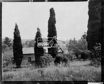
Photograph, John Collins, Shillinglaw Cottage on its original site, 17 Oct. 1963
... , State Library of Victoria. Shillinglaw Cottage is significant..., State Library of Victoria. Shillinglaw Cottage is significant ...Shilinglaw Cottage in its original location on Main Road Eltham with the “Shillllinglaw trees”. This image was taken shortly before its relocation. Believed to be have been taken by John Collins, 17 Oct 1963 as per other images held by the State Library of Victoria Author / Creator: John T Collins 1907-2001 , photographer. J.T. Collins Collection, La Trobe Picture Collection, State Library of Victoria. Shillinglaw Cottage is significant to Eltham’s local history. It is one of the earliest known buildings still in existence. Records suggest that the cottage was built circa 1859 by a man named Cochrane, believed to be Thomas Cochrane, in conjunction with George Stebbings though it is not known what Stebbings’s contribution was. It is made from hand made bricks laid in a Flemish bond pattern. In the 1960s it was marked for demolition to make way for the construction of new council buildings but a community campaign saved the cottage and it was re-located. It is believed Stebbings owned the cottage between 1874 and 1888. According to Margaret Ball’s (2017) book Shillinglaw Family of Eltham 1660-2007, Thomas Cochrane and family lived there from 1867 to 1874 however this is contrary to the records of assessable rates levied by the Eltham District Road Board, established in 1858, which shows Cochrane was the owner occupier (in Little Eltham) of approximately 25 acres of cultivated land and 25 acres of pastureland upon which a hut was sited in 1860. It is suspected that George Stebbings may have acquired the property from Cochrane in 1874 as it is noted that he had a tenant for a period, James Rossiter, who was the editor for the Evelyn Observer in Kangaroo Ground in 1874 (LATE SHIRE OFFICE AT KANGAROO GROUND (1934, February 16). Advertiser (Hurstbridge, Vic. : 1922 - 1939), p. 5. Retrieved February 25, 2022, from http://nla.gov.au/nla.news-article56743657). In 1881 Phillip Shillinglaw became the ratepayer for the cottage though Stebbings retained ownership until 1888 at which time it was transferred to Shillinglaw. This photo forms part of a collection of photographs gathered by the Shire of Eltham for their centenary project book, "Pioneers and Painters: 100 years of the Shire of Eltham" by Alan Marshall (1971). The collection of over 500 images is held in partnership between Eltham District Historical Society and Yarra Plenty Regional Library (Eltham Library) and is now formally known as 'The Shire of Eltham Pioneers Photograph Collection.' It is significant in being the first community sourced collection representing the places and people of the Shire's first one hundred years.Digital image 4 x 5 inch B&W Negsepp, shire of eltham pioneers photograph collection, eltham, shillinglaw cottage, shillinglaw trees, significant tree -
 Orbost & District Historical Society
black and photograph / postcard, 1.4.1908
... in The State Library, Victoria. The Snowy River Mail and Tambo... in The State Library, Victoria. The Snowy River Mail and Tambo ...This postcard was sent to Annie Gilbert (Mrs John Gilbert) of Tullagoota, Orbost. It was written by "Grace", probably her sister, Grace Cameron Annie Gilbert was the daughter of John Cameron who selected the first land on the Snowy River flats. This is a photograph of the original Orbost / Snowy River Bridge , a suspension bridge which opened in 1893. It has been taken when the Snowy River was in flood. It is similar to other photographs held in The State Library, Victoria. The Snowy River Mail and Tambo and Croajingolong Gazette Sat 12 Aug 1893 records the opening of this bridge as "the most important public event that has yet been commemorated in Eastern ......The Messrs McLeod, with whom the first settlement of this district is generally associated, took up their residence on the eastern bank of the Snowy River about the year 1841 or 42. The late Mr W. Roadknight and Mr T. T. Stirling took possession of the territory on the western side of the Snowy about 35 years ago. During the occupation of the country by cattle owners, very little progress was made in the way of roads and bridges, and except to the hardy and lexperienced bushman, it might have been generally regarded as inaccessible. About the year 1877, however, the late Mr James Robertson eldest son of Mr James Robertson, of Lochend farm, selected land now occupied by his father, about four miles from Orbost on the west bank of the river, Mr John Cameron visited the. district shortly after a .tour of inspection and returned later with his brothers, James and Alick Gameron, but found that during their absence Mr Ernest Watt had found his way on the scene and pegged out a selection, thus anticipating the advent of the Camerons by about 12 hours. We understand that a Mr Kidd, who selected the property now occupied by Mr W. J. Ross, at Pumpkin Point, was one of the earliest batch of settlers.........."This item is associated with Annie Gilbert (nee Cameron) reported to have been the first white girl to be born in Orbost. It is a pictorial record of the suspension bridge over the Snowy River which has since been replaced twice.A faded black / white postcard of a bridge across a river. There are cattle in the river and the banks are tree-covered.on back - a hand-written letter addressed to Mrs J. Gilbert Tullagoota Orbost.cameron-annie suspension-bridge-orbost snowy-river-orbost -
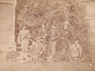 The Beechworth Burke Museum
Photograph
... their survival in the State Library of Victoria today. Thus image... their survival in the State Library of Victoria today. Thus image ...According to the Victorian Patents Office Copyright Collection (VPOCC) index, Barnes' image was first published on July 3, 1880. Many of the photographs taken by William Barnes concerned with the Kelly Gang were registered with the VPOCC which has ensured their survival in the State Library of Victoria today. Thus image includes the depiction of Sergeant Arthur Loftus Maule Steele (kneeling in front row) surrounded by seven other men. These men are identified as belonging to the Wangaratta police who played a key part in the destruction of the Kelly Gang at Glenrowan. These men could include Constables Causey, Montiford, Patrick Healey, Walsh, William Moore, Dixon and James Dwyer. It is also suggested that the individual standing back right (in the dark coat) is Constable Hugh Bracken, a key figure in the Glenrowan Siege. The police in this image display their firearms in a manner which reflects photographs of hunters, an element which was typical for this period. This photograph is part of the Burke Museum "Kelly album" which includes a significant collection of photographs and artefacts connected to Ned Kelly and the Kelly Gang. Ned Kelly and his gang have become ingrained in Australian popular culture and thus many museums, art galleries and private collections house material connected to the Kelly story which allows the events and people to be researched and interpreted. Artefacts and photographs pertaining to the Kelly gang are particularly valuable for Australian museums. This particular photograph is significant for its connection to Wangaratta photographer William Barnes who is responsible for having taken and registered many images depicting members of the Kelly gang. The photograph is also of artistic significance as an example of a photograph dating to 1880. This image depicts members of the Wangaratta police shortly after the defeat of the Kelly gang at Glenrowan. This photograph has the capacity to provide important information about the police who took part in Glenrowan 1880 and depicts key figures like Sergeant Steele.Sepia photograph taken by professional photographer William Edward Barnes (1941-1916) in June of 1880. The photo depicts a contingent of Wangaratta police who were at the capture of the Kelly gang at Glenrowan on the 28th of June 1880. This group of eight men are photographed standing in front of foliage and between the sides of two brick structures. Four men stand upright behind four other men who are depicted in either a sitting, semi-lying or kneeling position.W.E.Barnes / photographer / Wangaratta / BMM8085 Police responsible / for Kelly's capture / (D.S. not there)kelly album, glenrowan, police, wangaratta police, ned kelly, ned kelly glenrowan, william barnes, photography, 1880, australian history, police photograph, sargent steele, sergeant steele -
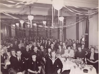 Glen Eira Historical Society
Photograph - Alma, Will
... in the State Library of Victoria, three dated 1961, and two dated 1943... CONJURING COLLECTION in the State Library of Victoria, three dated ...This file contains five items. Black and white photograph of the Magic Circle dinner in 1945, location unknown, taken by Morton Photography. Black and white photograph of attendees at the Magic Circle’s welcome dinner for New Zealand magician Ces Morris in 1946, location and photographer unknown. Two copies of a black and white photograph of the Magic Circle dinner of either 1947 or 1949, location unknown, taken by Morton Photography. Black and White photograph of magician THE AMAZING W. BROOKLYN at the Melbourne Tivoli Theatre in 1945, photographer unknown, autographed to Dick Ballantine. Five black and white photographs of Will Alma, photographer unknown, copies from the ALMA CONJURING COLLECTION in the State Library of Victoria, three dated 1961, and two dated 1943. Two photocopies in black and white of photographs of an elderly man. One is labelled 'Will Alma Conjuring Memorabilia Collection Melbourne Australia'. The other is not labelled but appears to be same man. Date taken and photographer unknown.alma will, magic circle, alma conjuring collection -
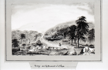 Eltham District Historical Society Inc
Photograph, Daniel Rutter Long, Bridge over the Diamond near Eltham, Daniel Rutter Long, 1855
... . (State Library of Victoria).... (State Library of Victoria) This photo forms part of a collection ...Daniel Rutter Long was born in England, after training as a pharmacist he, his wife and family emigrated to Port Phillip, Victoria in 1840. By 1843 he had his own chemist shop in Bourke Street, later erecting a well known pharmacy on the corner of Bourke and Exhibition streets. During the gold rush of the 1850s he purchased gold at the shop for shipment to a Quaker syndicate in London. Retiring from the business in 1857 Long took up painting, sometimes returning to his original profession. He painted hundreds of landscapes in other colonies as well as in Victoria. Long participated in local affairs and was one of the earliest members of the municipal council. Later he was elected mayor and instrumental in the in the erection of Prahran Town Hall. He was also a member of the Police Court Bench for many years. Daniel Long died at the age of eighty-three in 1886. (State Library of Victoria)This photo forms part of a collection of photographs gathered by the Shire of Eltham for their centenary project book,"Pioneers and Painters: 100 years of the Shire of Eltham" by Alan Marshall (1971). The collection of over 500 images is held in partnership between Eltham District Historical Society and Yarra Plenty Regional Library (Eltham Library) and is now formally known as the 'The Shire of Eltham Pioneers Photograph Collection.' It is significant in being the first community sourced collection representing the places and people of the Shire's first one hundred years.Digital image 35mm B&W negativeshire of eltham pioneers photograph collection, bridge, daniel rutter long, diamond creek (creek), eltham, sepp -
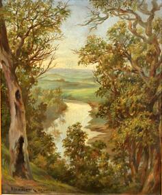 Kew Historical Society Inc
Painting, Herbert J Woodhouse, River Yarra Near Dights Falls, c.1892
... in the collection of the State Library of Victoria.... in the collection of the State Library of Victoria. Oil painting on board ...Herbert James Woodhouse (1854-1937) was born in Essex and arrived in Australia with his family in 1857. A painter-lithographer like his father and three of his brothers, he was a prizewinner in the South Australian Society of Arts exhibition of 1885. He also received commendations in exhibitions at the Victorian Academy of Arts and the New South Wales Arts Society. At an exhibition of his paintings at Scott’s Hotel in Collins Street in 1892, the reviewer for Table Talk noted that the ‘artist paints almost solely in the open air, and his studies are generally carried out during the trips of the Victorian Sketching Club’. One of the paintings singled out for praise was: ‘A very effective river scene at Willsmere, aptly named A Midstream Mirror, ... a picture powerful in its effective reflection of sunlight in the river.’ Herbert Woodhouse died in Geelong in June 1937, aged 82, and was buried in the Eastern Cemetery. A number of his sketchbooks are held in the collection of the State Library of Victoria.Framed oil painting on board of the River Yarra at Studley Park, Kew, by Herbert James Woodhouse (1858-1937). The artist has framed the narrow painting with trees in the foreground and a view of the Yarra River and rolling hills in the background. Verso, written by artist: "River Yarra Near Dights Falls"australian art - 19th century, herbert james woodhouse (1854-1937), yarra river - studley park -
 Ballarat Tramway Museum
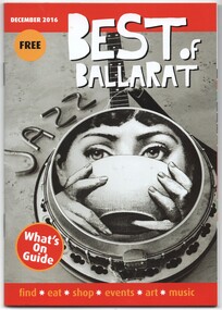
Book, Scott Bain, "Best of Ballarat", Nov. 2016
... with the Bugatti is from the State Library of Victoria.... with the Bugatti is from the State Library of Victoria. "Best of Ballarat ...Book - 44 pages, centre stapled, full colour, titled "Best of Ballarat", for Dec 2016. Gives details of events, locations, hotels, food etc - a What's on in Ballarat. Has the Peter Bruce photo (see Reg Item 6702) on page 19 under attractions and tours, and on page 21, adverts for the BTM and Cuthberts939. 6703.2 - ditto - for April 2017, images i4 to i9, including cover, Sturt St, BTM, maps - added April 2017. 6703.3 - ditto for August 2017, images i10 to i12- includes cover, photo of the interior of Cuthberts939 on page 23 and a general advert on page 24 - added August 2017. 6703.4 - ditto for Feb. 2018, images i13 to i15 includes cover, Welcome to Ballarat including photo of a Bugatti motor car and tram 18 in Lydiard St North, c late 1940's and the general advert on page 24 - added Feb. 2018. The image with the Bugatti is from the State Library of Victoria.trams, tramways, ballarat, btm, events, hotels, cuthberts 939, lydiard st north -
 University of Melbourne, Burnley Campus Archives
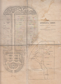
Plan, Alfred Lynch, Plan of the Experimental Gardens of the Horticultural Society of Victoria. Survey Paddock. Richmond, 1861
... held by the State Library of Victoria. 1 large and 1 small..., 1862. It is only in one of the copies held by the State Library ...Subsequently the area was not fully developed in this manner following flooding in 1863. Some remnants remain.Plan on paper with cloth backing. Inscription, "Designed by Alfred Lynch. Landscape Gardener, Prahran. Printed by De Guchy & Leigh." An inset plan shows position of Experimental Gardens related to the City of Melbourne and Bay. Plan shows layout and plantings of the designated area - fruit, vegetables: the conservatory, nursery, exhibition buildings. This plan was owned by E.E. Pescott. Inscription on cover, "Burnley. E.E.P.." "Ed. E. Pescott." Subsequently the area was not developed in this manner. See inscription on copy made for Centenary Exhibition B92.633. Other copies given to College by N. Lothian (graduated 1934). Jim Sanders, a friend of his, gave them to Dr. G. Moore in 1991. A larger copy, inscribed on reverse, '1861', 'Early proposals for Horticultural Gardens for Horticultural Society of Victoria (now Royal). The lithograph was included as an insert in the Farmers Journal and Gardeners Chronicle 21 June, 1862. It is only in one of the copies held by the State Library of Victoria. 1 large and 1 small photographs of plan. Several photocopies of the plan.Inscription, "Designed by Alfred Lynch. Landscape Gardener, Prahran. Printed by De Gruchy & Leigh." / Inscription on cover, "Burnley. E.E.P.." "Ed. E. Pescott."alfred lynch, experimental gardens, conservatory, nursery, e.e. pescott, n. lothian, jim sanders, dr. g. moore, horticultural socoety of victoria -
 Eltham District Historical Society Inc
Negative - Photograph, Shillinglaw Cottage, 17 Oct. 1963
... images held by the State Library of Victoria Author / Creator... images held by the State Library of Victoria Author / Creator ...Shilinglaw Cottage in its original location on Main Road Eltham with the three Mediterranean Cypress trees (“Shillllinglaw trees”) in the garden. Note a fourth pine to the right. This image was taken shortly before its relocation. Believed to be have been taken by John Collins, 17 Oct 1963 as per other images held by the State Library of Victoria Author / Creator: John T Collins 1907-2001 , photographer. J.T. Collins Collection, La Trobe Picture Collection, State Library of Victoria. Shillinglaw Cottage is significant to Eltham’s local history. It is one of the earliest known buildings still in existence. Records suggest that the cottage was built circa 1859 by a man named Cochrane, believed to be Thomas Cochrane, in conjunction with George Stebbings though it is not known what Stebbings’s contribution was. It is made from hand made bricks laid in a Flemish bond pattern. In the 1960s it was marked for demolition to make way for the construction of new council buildings but a community campaign saved the cottage and it was re-located. It is believed Stebbings owned the cottage between 1874 and 1888. According to Margaret Ball’s (2017) book Shillinglaw Family of Eltham 1660-2007, Thomas Cochrane and family lived there from 1867 to 1874 however this is contrary to the records of assessable rates levied by the Eltham District Road Board, established in 1858, which shows Cochrane was the owner occupier (in Little Eltham) of approximately 25 acres of cultivated land and 25 acres of pastureland upon which a hut was sited in 1860. It is suspected that George Stebbings may have acquired the property from Cochrane in 1874 as it is noted that he had a tenant for a period, James Rossiter, who was the editor for the Evelyn Observer in Kangaroo Ground in 1874 (LATE SHIRE OFFICE AT KANGAROO GROUND (1934, February 16). Advertiser (Hurstbridge, Vic. : 1922 - 1939), p. 5. Retrieved February 25, 2022, from http://nla.gov.au/nla.news-article56743657). In 1881 Phillip Shillinglaw became the ratepayer for the cottage though Stebbings retained ownership until 1888 at which time it was transferred to Shillinglaw.Shillinglaw Cottage is itself historically, aesthetically and socially significant to the Shire of Nillumbik and is registered on the Victorian Heritage Database. This photo forms part of a collection of photographs gathered by the Shire of Eltham for their centenary project book, "Pioneers and Painters: 100 years of the Shire of Eltham" by Alan Marshall (1971). The collection of over 500 images is held in partnership between Eltham District Historical Society and Yarra Plenty Regional Library (Eltham Library) and is now formally known as 'The Shire of Eltham Pioneers Photograph Collection.' It is significant in being the first community sourced collection representing the places and people of the Shire's first one hundred years.Digital image 4 x 5 inch B&W Negsepp, shire of eltham pioneers photograph collection, eltham, shillinglaw cottage, significant tree -
 Mission to Seafarers Victoria
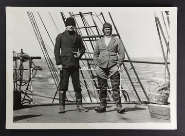
Photograph, Peckham Photographic Studios, Geo Beachcroft, Capt Dahlström and 2nd mate of the C.B. Pedersen, c. 1935
... Library of Victoria.... Library of Victoria. see links above crew c.b pedersen captain ...In the Sydney Morning Herald, Tuesday 27 April 1937, page 12: "The C. B. Pedersen was built in 1891. It has visited Australia several times, the most recent occasion having been in 1935, when It was anchored in Port Phillip Bay, Victoria, for several weeks, awaiting a suitable cargo. At length the master, (Captain Hjalmar Dahlström) announced that, as no cargo could be obtained he would be prepared to carry passengers in a voyage to Gothenburg, via Torres Strait. Eight persons, including three women and a small boy were accepted as passengers, and signed on as members of the crew at salaries of 1/ a month". Artist Violet Teague was one of the passengers. She painted during the voyage and exhibited her work in 1938. Built in 1891 the C.B Pedersen, a four-masted steel barque (2142 tons) was used as a training Barque. The ship foundered in April 1937, the crew was saved. Several photographs of the C.B. Pedersen taken by the same studio are held at the State Library of Victoria.see links aboveBlack and white photograph depicting two sailors in attire on the deck of a ship.verso in Black ink; Photographic studio stampcrew, c.b pedersen, captain hjalmar dahlström, violet teague, windjammer -
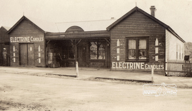 Eltham District Historical Society Inc
Photograph, Lloyd's Store, Main Road, Eltham, c.1916-c.1922, 1920c
... of print/digital file sourced from State Library of Victoria: Title... of print/digital file sourced from State Library of Victoria: Title ...Store was located opposite Dudley Street. Note various signs for Electrine Candles, Baker, Cadburys Cocoa, Cadburys Chocolate (in window) and Refreshment Room (faded). Edited version of print/digital file sourced from State Library of Victoria: Title: Lloyd's Store, Eltham, [Vic.] [picture]. Date: [ca. 1916-ca. 1922] Description: 1 photographic print : gelatin silver ; 6.6 x 10.8 cm. Copyright status: This work is out of copyright Terms of use: No copyright restrictions apply. Identifier(s): Accession no:H86.93 Subjects: Eltham (Vic.) -- Buildings, structures, etc; Victoria -- History -- 1901-1922; Gelatin silver prints Index terms: Shops; Victoria Notes: Title inscribed in ink on verso. Photographer unknown. Undated, date range provided by donor. Contents / Summary: Looking across street towards weatherboard store with porch at doorway, signs painted on front of store read: Electrine Candles. Source / Donor: Gift; Mrs. Nancy Graham; 1986.Copy of sepia photographbaker, cadburys chocolate, cadburys cocoa, lloyd's store, refreshment room, slv, shops -
 Glen Eira Historical Society
Article - CAULFIELD RAILWAY STATION
... Station]’ c1915, from State Library of Victoria (print dated 12/06... Railway Station]’ c1915, from State Library of Victoria (print ...This file contains four items: 1/Press cutting from Caulfield Contact, November 1991 (brief report, with photograph of Caulfield Station passengers boarding the steam engine K163 bound for Frankston on Public Transport Open Day). 2/Five pages (stapled together) of photo copied recommendations and assessment by Andrew Ward, March 1995, relating to the history, condition and conservation of the Caulfield Railway Station complex (includes four photocopied photographs). 3/Six pages (stapled together) of material from Heritage Victoria, to B. Evans, Environment Offices, Bayside Trains, 05/03/1999 (two sheets), with enclosure (4 sheets) relating to the cultural heritage significance of the Caulfield Railway Station complex (includes one photocopied photograph). 4/Photocopy of postcard (gelatin silver photograph) of ‘Three new railway lines, train going to Oakleigh [at Caulfield Railway Station]’ c1915, from State Library of Victoria (print dated 12/06/2013).caulfield railway station, b. evans, steam engines, railway stations, railway buildings, ray tonkin, heritage victoria, andrew ward -
 Bendigo Historical Society Inc.
Document - ROYAL PRINCESS THEATRE COLLECTION:PHOTOCOPIES OF EXTERIOR AND INTERIOR
... Cowper and Murphy State Library of Victoria, 6. Royal Princess... service station designers Cowper and Murphy State Library ...Eighteen photocopy photographic images of Princess Theatre exterior and interior. 1. Royal Princess Bendigo main auditorium, 2. Royal Princess Bendigo Auditorium dome and chandelier, 3. Royal Princess Bendigo main auditorium views from upstairs circle, 4. Royal Princess Bendigo. Downstairs front stalls, 5. Royal Princess Bendigo View Street closed Saturday 4th May 1963 last Movie 'Guns of Navarone' became amaco service station designers Cowper and Murphy State Library of Victoria, 6. Royal Princess Bendigo Downstairs foyer, 7. Princess main entrance, 8. Princess circle entrance, 9. Princess Theatre was built behind the Albion Chambers, 10. Royal Princess Bendigo 1875 2000 seats 1800seats later, 11. Royal Princess front stalls and stage, 12.. Advertisement Bendigo Advertiser Tuesday December 22 1908 top right hand corner, 13. Advertisement Bendigo Advertiser Thursday march 10 1910, 14 Advertisement Bendigo Advertiser Tuesday July 26 1910, 15 Advertisement Bendigo Advertiser Thursday July 28 1910.bendigo, buildings, princess theatre -
Ballarat Tramway Museum
Document - Report, Maunsell Pty Ltd, "City of Ballarat - Feasibility Study for Reinstatement of the Ballarat Trams - Final Report - July 1998", Jul. 1998
... and Victoria St. lines. Has three State Library of Victoria photos... Pleasant and Victoria St. lines. Has three State Library ...Thirty six page (A4) plus 10 folded A3 pages report with clear plastic cover, card rear cover and bound using a white comb binder, featuring a black and white photograph of BTM No. 33 on front cover. Report titled "City of Ballarat - Feasibility Study for Reinstatement of the Ballarat Trams - Final Report - July 1998". Report looks at background, geometric criteria, depot location, alignment proposals, the BTM, existing tramcars, availability and sources of materials, tramcar requirements, operational equipment and has an Appendix. Prepared as revision F, Final report 31/7/1998 by Richard Darby of Maunsell Proprietary Limited in association with Allom Lovell and Associates Pty Ltd. Contains a A3 map of the main area of "original tramway system" - excludes Sebastopol and ends of Mt Pleasant and Victoria St. lines. Has three State Library of Victoria photos of Ballarat, three folded A3 sheets containing 12 photographs each of the 1998 conditions, four fold A3 sheets of the proposed route showing photo locations, suggested loops and two folded A3 sheets of cross sections.trams, tramways, city tramway, ballarat tramways, maunsell, tramway revival -
 Bendigo Historical Society Inc.
Negative - Photos of Bendigo - Glass Plate Negatives, Early 1900s
... negatives went to the State Library of Victoria - currently being... negatives went to the State Library of Victoria - currently being ...Three Boxes of Glass Plate Negatives and six black and white photos. 1. Box 1 Eight whole plate negatives of Pall Mall, Bendigo. Copies from original photos, or negatives made by the Army Survey Regiment stationed at Fortuna Villa. The original photos were taken by Alan Fox in 1857 and are in the State library of Victoria - currently being scanned. 2. Box 2 Fourteen half plate glass negatives collected from Bartlett's (Vincent Kelly) studio, Pall Mall, Bendigo by Mike Butcher. Many other negatives went to the State Library of Victoria - currently being scanned. 11072.1k Group of men and Children, and dog at a cricket match at the side of a sports pavilion. Group of men, maybe a team of runners. Child in clothing with Kentish Flour sew-ons and hat with wheat on the top. Miss Cohn, 6/7/1911 Mr A Robinson, 31/3/1904 Mr Ah Hoy, 19/4/1903 Mr Ah Gay, 19/11/1903 Mr Ah Gay and one other, 19/1/1903 Mr Ah Hoy, 22/12/1902 Mr Ah Hoy, 22/12/1902 Mr Kim Ah Hoy, 22/12/1902 Mr Kim Ah Hoy, 22/12/1904 Mr Deravin, 5/6/1902 3. Box 3 Bendigo Railway Station and Encroachments - 9 Quarter glass lead Plates in a box labelled "Kahland Collection. Content railway station, locomotives and signal box, Bendigo Railway Station. 11072.a Bendigo Railway Station from the Mitchell Street Bridge 4. Six black and white photos printed taken by Allan Doney - currently being scanned. 11072.1af Bendigo Arcade Pall Mall next to Myers. 11072.1ag Easter 1955 Junior Fire Brigade pulling fire cart with portrait of Queen Elizabeth 2 on the corner of Park Road and Bridge Street. 11072.1ah School of Mines Float Easter procession 1954. 11072.1ai Hustlers Terrace Bendigo 11072.1aj Limerick Castle Hotel Williamson St Bendigo 11072.1ak Christian Science Society 15 McKenzie St., Bendigo, on the left at 11 McKenzie St., formerly "Legacy House", now the Bendigo Historical Society. On the extreme left is the rear of the Princess theatre in View St. photos, bendigo, bendigo railway yards, mike butcher collection -
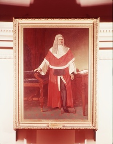 Supreme Court of Victoria Library
Portrait, Robert Dowling, Sir Redmond Barry, 1886
... (the University of Melbourne, the State Library of Victoria, the Supreme... of Melbourne, the State Library of Victoria, the Supreme Court Library ...This painting was created by Robert Dowling (1827-1886) in 1885. At this time Dowling was considered Australia's best portraitist. Dowling had been born in England, but migrated to Van Diemen's Land in the early 1830s with his parents. Dowling worked in both Tasmania and Victoria as an artist, before returning to England in 1857. He did not return to Australia until 1884 and received eighteen commissions for portraits. The Barry portrait was commissioned after Barry's death which explains some of the mistakes in the depiction of Barry's robes; the fur cuffs and collar are too large, and the cummerbund is sitting in the wrong place. Sir Redmond Barry is an important figure in Colonial Victorian History, responsible for the establishment and support of some of our finest cultural institutions (the University of Melbourne, the State Library of Victoria, the Supreme Court Library, and aspects of the Museum of Victoria's collection). This is in addition to his role as barrister defending aborigines in the 1840s and his position as a foundation judge of the Supreme Court of Victoria, a position he held for nearly 30 years, presiding over two of the most well known of colonial trials: the Eureka Trials in 1854 and the Kelly trial in 1880.The portrait of Sir Redmond Barry is significant because of the historical importance of Redmond Barry in colonial Victorian history. The painting is also of aesthetic significance as the work of the distinguished portraitist Robert Dowling. Portrait in oils of Sir Redmond Barry. Barry is depicted standing, dressed in red Judicial robes, his hand resting on a chair; behind is a table with books.Signed and dated 1886 (lower left) by Robert Dowling.redmond barry, portraits, judges, robert dowling -
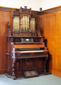 Mission to Seafarers Victoria
Instrument - Reed organ, W Bell & Co, c. 1888
... Library Victoria). In 1972, it was transferred to the Holy... Library Victoria). In 1972, it was transferred to the Holy ...This organ was gifted by the Bethel Community in 1890 to the then Victorian Seamen's Mission, originally founded by the Bethel Union in 1857. The gift was intended to assist with worship. Despite all appearance, this organ is not a pipe organ but a reed organ that works in a similar manner to an accordion. In May 1890, the sum of seventy pounds was put towards the purchase of the organ. The sum being raised via subscriptions. The organ was inaugurated in September 1890. Jabez Carnegie (1832-1892), importer of piano and organs in Melbourne, had made a trip to Europe and Canada in 1887 and had secured the agency of Bell organs. W. Bell & Co were a Canadian organ and piano manufacturer, considered the premier organ manufacturer of the time. W Bell & Co changed its name to Bell Organ and Piano Co in 1888 meaning this organ had to be manufactured prior to the name change. The organ was first used in the mission main room from 1890 to 1915 when the St Nicholas chapel was built at the back (see item 0548. It was transfered to the new Port Melbourne mission in 1937 (link on postcard from State Library Victoria). In 1972, it was transferred to the Holy Trinity Church in Bay Street after the closure of the Mission In the late 1980s during a National Trust campaign to save the building, the organ was sold by the Anglican Men's Society to the Trust's organ committee, who carried out some restoration work and returned it to the former Missions to Seamen chapel. In 1991 the Office of Major Projects had control of the whole 'Bayside' development site. With the Mission to Seamen Building emptied and proposed for demolition, the Office of Major Projects removed the organ and placed it in storage in various locations - finally, in the Museum of Victoria store in Abbotsford. In 1995-6, enquiries by Jim Hillis resulted in the return of the organ to the control of the Port Melbourne HIstorical & Preservation Society. As the Society had no suitable location for the organ, several churches and schools in Port Melbourne were approached to take the organ with no results. The nearby suburbs were suggested next. Finally the Melbourne Maritime Museum (Polly Woodside) was approached and agreed to place it in their Museum on a long term loan. In 1997 it was on display in no 5 shed South Wharf (23/3/1997). In 2006, the Polly Woodside South Wharf site was to be re-developed, and they could no longer retain the organ. Accordingly, on 4 May 2006, the organ was transferred to the Mission To Seafarers building in Flinders Street Extension as an indefinite loan (refer OL 022) The PMHPS deaccessioned it to finally transfered it in 2018 to MTSV.(See also acquisition details re 21st C finalisation of acquisition) This organ is a tangible reminder of the longevity of the Mission to Seafarers, a link with the original Bethel Union which was instrumental in 1856 calling a public meeting and inviting subscriptions by various non-conformist churches to found a mission to Seamen. Rev Kerr-Johnson delivered the first service in 1857 aboard the Emily. The Mission to Seafarers has been in operation ever since and continues to operate to the same purpose today.Large reed organ that looks like a pipe organ with fifteen elaborately painted pipes bearing a floral motif. The body of the organ is elaborately decorated in carved wood. It has 17 knobs above the keyboard both which can be concealed when the keyboard cover is lowered. There are two foot pedals at the bottom of the organ with "Mouse Proof Pedals" cast into the framing iron. list of stop names: Viola 4Ft Diapason 8Ft Dolce 4Ft Violetta 2Ft Sub Bass 16 Ft Octave Coupler Vox Humana Forte Picciolo 2Ft Hautboy 8Ft Aeoline 8Ft Cremona 16Ft E---bone 16Ft Echo 8Ft Celeste 8Ft Melodia 8Ft Flute 4FtMaker's mark in gold lettering above keyboard: W. Bell & Co Brass plaque on front board: Presented to/The Victorian Seamen's Mission/by/Congregation worshipping in Bethel/& friends./1st September 1890 Behind the stops a wooden plaque: J. CARNEGIE & SONS, SOLE AGENTS FOR VICTORIA MELBOURNE organ, worship, bethel, pipes, reed, bethel union, pipe top, jabez carnegie, w. bell & co, port melbourne, mission to seafarers, seamens' mission, mission to seamen, guelph, ontario, canada, pmhps, polly woodside, harmonium, reed organ -
 Eltham District Historical Society Inc
Photograph, Liz Pidgeon, Heritage Excursion; The 1901 Eltham Railway Walk, 3 May 2014, 3 May 2014
... . Copies of these plans from the State Library of Victoria.... Copies of these plans from the State Library of Victoria ...Newsletter No. 216, May 2014 May Excursion – The 1901 Eltham Railway Walk The railway from Heidelberg to Eltham was opened in 1902. Over the previous year railway construction cut a curving swathe through Josiah Holloway’s 1851 Little Eltham subdivision. The survey plans for the railway show the owners and occupiers of land within Little Eltham affected by the railway alignment and for some distance each side. The plans show houses and other buildings but development at that time was rather sparse. Copies of these plans from the State Library of Victoria collection have been provided to the Society by Alan Sheehan. For our walk on 3rd May we intend to follow the railway from the Eltham Station to Ryans Road, which was the boundary of the adjoining Montmorency Farm. The return will be by way of nearby streets. Along the way we will discuss the details shown on the railway plans as well as more recent railway documents and photographs. At the conclusion and if time permits we can inspect the historical display at the Eltham Station. The walk is about 3 km in length and will take about 2.5 hours. It will start at 2 pm at the Eltham Railway Station car park (east/Main Road side) (Melway Ref. 21 J5).Born Digitalheritage excursion, activities, eltham district historical society, eltham railway station, eltham library, trestle bridge