Showing 112627 items matching "tracks/roads"
-
 Glen Eira Historical Society
Letter - Westfield, Corner Eskdale and Wyuna Roads, Caulfield North
... Eskdale and Wyuna Roads, Caulfield North, Victoria ...Letter from George Stevens to Caulfield Historical Society dated 27/08/2001 regarding the owners of Westfield 1904 to 1952 plus a brief history of the property and the reason for the house name. Photocopy of two photographs plus handwritten notes on the value, owners and builder of Westfield.caulfield historical society, caulfield’s building heritage, eskdale road, kambrook road, wyuna road, stevens george, pescott david james, pescott james richard, pescott keith woodfull, heathcote norman, westfield, wyuna road, woodfull cecily, woodfull dorothy, heathcote norman mrs., heathcote norma, oakley norma, house names, solomon g. dr., dunbar margaret, leonard f., leonard s., timber houses, land values, heathcote dorothy -
 Glen Eira Historical Society
Photograph - Nithsdale
... Corner Kambrook and Glen Eira Roads, Caulfield North ...This file contains 2 items (4 images) of this property: One reproduction of photograph of Nithsdale, date unknown in black and white. Two photographs of tower (different angles of front) at Nithsdale, date unknown in black and white plus one photocopied photo of tower. All three are copies of photographs in 'Historical Caulfield to 1972' compiled by Mrs Jenny O'Donnell, taken between 1966-1972 and held by the Glen Eira Historical Society (p102).nithsdale', architectural features, towers, caulfield north, kambrook road, glen eira road, 'five way hill' -
Glen Eira Historical Society
Document - Nithsdale
... Corner Kambrook and Glen Eira Roads, Caulfield North ...Photocopied copy of flyer for forthcoming subdivision of Caulfield Heights Estate on 27/10/1888. Includes locality plan and subdivisions. Photocopied copy of flyer for forthcoming sale of properties and mansion, Nithsdale on 18/09/1889, includes map of area.carriages and coaches, caulfield heights estate, caulfield north, maxwell grove, kambrook road, neerim road, blake street, bambra road, racecourse road, auctioneers, station street, glen eira road, paynes j., mansion, beauchamp brothers -
Glen Eira Historical Society
Plan - Nithsdale
... Corner Kambrook and Glen Eira Roads, Caulfield North ...This file contains one item about this property: Three postcard sized photographs of a flyer for the subdivision sale of the area incorporating this property for Saturday 22/11/1924. The flyer shows photographs (black and white) and plan of the area around 'Nithsdale'.nithsdale', caulfield north, hudson street, bambra road, kambrook road, centre way, oak court, caulfield railway station, balaclava road, glenhuntly road, caulfield racecourse -
 Glen Eira Historical Society
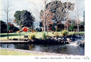
Article - HARLESTON PARK, ELSTERNWICK
... Seymour & Allison Roads, Elsternwick, Victoria, Australia ...This file contains 2 items, viz: 1/Press cutting from the Melbourne Herald (01/06/1974) regarding opposition by some Elsternwick residents to plans by Caulfield Council to install gas barbecues in Harleston Park. 2/Five coloured photographs of the park i.e three glossy prints: on verso of one ‘Harleston Park circa 1972’ and on the others ‘Harleston Park’; two matt prints, on verso of each, ‘Harleston Park, 1982’.harleston park, ross albert, ross mrs albert, brodie william, meldrum frank, wilson kerry, allison road, seymour road, parks and reserves, newspapers, barbecues -
Glen Eira Historical Society
Ephemera - CAULFIELD YOUTH COUNCIL
... Corner Hawthorn and Glen Eira Roads, Caulfield, Victoria ...This file contains two items: 1/A poster for the Caulfield Youth Council’s Caulfield Youth Cabaret at the Caulfield Town Hall 2/A program for Caulfield Youth Council’s presentation of the Caulfield Youth Cabaret on 27/11/1988 at the Caulfield Council Auditorium. It lists the acts for the evening.caulfield youth cabaret, caulfield council auditorium, caulfield secondary college, sefra bursten school of dance, hosking david, teenagers, elitzer, youth, fusion, caulfield festival, caulfield arts centre, caulfield town hall, hawthorn road, glen eira road, gelberg vicki, caulfield, caulfield youth council, theatre restaurants, young adults, cultural structures and establishments, festivals and celebrations, dance studios, schools, entertainers, theatrical productions, drama, colleges, singers, secondary schools, poetry -
Glen Eira Historical Society
Document - COATESVILLE UNTING CHURCH CORNER NORTH AND MACKIE ROAD
... Corner North and Mackie Roads, Bentleigh East, Victoria ...Two items about this church: 1/Photocopied details of the Church’s preliminary stages of development at Coatesville Uniting Church. 2/Photocopied article with brief details of Coatesville parish history which includes East Bentleigh Presbyterian and South Oakleigh Methodist parishes.south oakleigh methodist church, reid a, north road, coatesville uniting church, bray mr, mackie road, harris mr, phillips l.g. rev, okey mr, adams mr, williams w.j. rev, murrumbeena, harris mr, iliffe w.r, hallibone mr, fielding mr, reynolds mr, nancarraw mr, reic a mr, thomas miss, winter mr, lanym a. mr, sturgess h mr, sturgess mrs, duncan annie, duncan gordon, sturgess edith, evans chas, ralton mr, architects, coatesville parish, uniting church, east bentleigh presbyterian church, cecil street, peerman alex rev, east bentleigh presbyterian, market gardens, st christopher’s church, bell a.f. rev, body alan rev, jassa street, manses, trevorrow mr, halls, sunday schools, bentleigh east -
 Glen Eira Historical Society
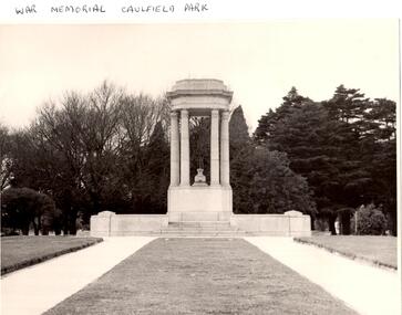
Article - Memorials in Glen Eira
... Corner Inkerman and Balaclava Roads, Caulfield, Victoria ...This file contains 11 items relating to War Memorials in Glen Eira: 1/Black and white photograph, undated, source unknown, of Caulfield Park War Memorial 2/Copy of photograph of Caulfield Park War Memorial, undated, source unknown 3/Colour photograph of Caulfield Park War Memorial, dated June 1982, source unknown, and slide of same 4/Print of webpage of Friends of Caulfield Park, dated 02/08/2013 with colour image of and information about the war memorial there 5/Two black and white photographs, undated and source unknown, of war memorial at Koornang Park 6/Four colour photographs and one black and white copy of photograph of war memorial and its inscription at Koornang Park. Date and source unknown 7/Article dated 30/04/2013 from GLENEIRA LEADER about funding for plaque for Lone Pine at Caulfield Park 8/Article dated 23/04/2013 from THE AGE about state funding for repair of war memorials including one at McKinnon 9/Article dated June 2013 from GLEN EIRA NEWS about state funding for repair of five WWI memorials in Glen Eira. Includes two photographs. 10/Article from GLEN EIRA NEWS dated April 2012 about restoration of Caulfield Park War Memorial. Includes colour photography 11/A booklet titled 'The Burra Charter and its Application: Essay 3: War Memorial, Caulfield Park', written in October 2000 by Eleanor Bishop. The booklet contains a conservation analysis, statement of cultural significance, statement of conservation policy, and conservation management plan for the Caulfield Park War Memorial. This includes a brief history and description of the Caulfield Park War Memorial, and 7 colour photographs of the memorial dated September 2000, 2 undated black-and-white photographs, and a copy of the original drawing of the memorial which won its design contest in 1930.monuments and memorials, war memorials, plaques, world war 1914-1918, caulfield park, friends of caulfield park, ritchie mr, world war 1939-1945, koornang park, city of caulfield, glen eira, glen eira council, mckinnon war memorial, hopetoun gardens, hyams jamie, mckinnon, lobo oscar, esakoff margaret, hyams jamie, delahunty ms, caulfield rsl, kiernan noel, bishop eleanor, caulfield park war memorial, foot henry b., parks and reserves, paddy's swamp, caulfield, royal victorian institute of architects, caulfield municipal council, architectural competitions, schefferle n. mr, architectural features, conservation management plan -
 Whitehorse Historical Society Inc.
Pamphlet - Fun Run Invitation, Atheletics Victoria, Whitehorse Mega Mile, A Two Mile Fun Run/Walk, 2003
... Whitehorse Road between Surrey and Springvale Roads ...A pamphlet and entry form to the advertise the Whitehorse Mega Mile on Sunday 30th November 2003 supported by patron Steve Monaghetti and prizes upto $15000.A pamphlet and entry form to the advertise the Whitehorse Mega Mile on Sunday 30th November 2003 supported by patron Steve Monaghetti and prizes upto $15000.non-fictionA pamphlet and entry form to the advertise the Whitehorse Mega Mile on Sunday 30th November 2003 supported by patron Steve Monaghetti and prizes upto $15000.fundraising events, commonwealth games, monaghetti steve, atheletics victoria, city of whitehorse -
 Whitehorse Historical Society Inc.
Photograph, Northcote Street, Mitcham, 8/09/1958 12:00:00 AM
Black and white photo of Northcote Street, Mitcham.- Eastern end of what is now Brunswick Road- Road (track ) conditions indicative of that part of the city.o'rourke, l. -
 Melbourne Tram Museum
Slide, Keith Kings, 10/10/1968 12:00:00 AM
35mm Kodak white cardboard colour slide by Keith Kings of 10/10/1968 of the concreting of the track to connect St Kilda Road into the junction further to the south and Wellington St replacement - Queensway. Note the temporary tram stop. Note the overhead trucks in the distance. The Junction Hotel in the far distance. See Keith's slide notes.Keith Kings stamp and number "41-30" and exposure details. In ink "St Kilda Jtn Bypass works - temporary junction in St Kilda Rd, south of new junction, replaced by new track, 1050am Sunday.trams, tramways, st kilda junction, fitzroy st, st kilda rd, trackwork, high st, tram stops -
 Hume City Civic Collection
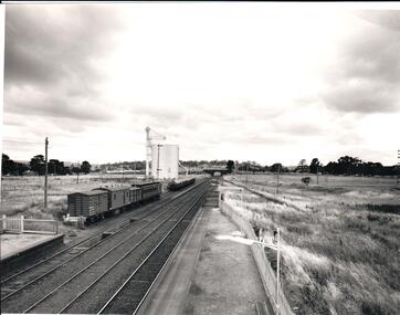
Photograph, 1/01/1971
The photograph was taken when railway land on either side of the tracks was used for recreational purposes and agricultural related activities. The local sports ground is on the RHS of the photograph and was used to stage a number of the town's events.A black and white photograph of a section of the two railway platforms and three sets of rail tracks with a stone bridge in the distance. Four rail carriages and eight goods trucks are on a railway siding near a wheat silo. There is open land on either side of the rail tracks.sunbury railway station, wheat silos, railways, macedon street rail bridge., george evans collection -
 Kew Historical Society Inc
Photograph, Stuart Tompkins Studio, Electricity Supply Poles, Warrigal Road, Ashwood, 1965
Research provided by Stuart Tompkins Studio, Box Hill, into alternatives for median strip street lighting to be used in Burke Road, Kew. The photographers identified variants in different suburbs appropriate to Kew's needs.The series from which the photograph is drawn provides a snapshot by a commercial photographic studio of each named vicinity in 1965 as well as providing examples of public works infrastructure being commissioned by local government in the 1960s. The photos originally formed part of the Engineering Department's files in the City of Kew before being donated to the kew Historical Society.Electricity Supply Poles, Warrigal Road, Ashwood, 1965. Stuart Tompkins Studio provided this photograph for the Kew City Council. The photograph, taken at the intersection of Warrigal Road and High Street South, Ashwood looks north along High Street Road. The intent of the photograph was to provide the Council with models of electricity supply poles. In the photo, wooden and steel poles can be seen in the median strip. The photograph also includes the shops bordering High Street Road during this period. [There are three copies of this photograph in the Collection.]. Typed inscription on reverse: "Electricity Supply Poles. Photographed for Kew City Council 8/2/65. No.4 Warrigal Road - Ashwood. South of High Street Road looking north. Wooden and steel poles with different brackets in median strip." Studio stamp: "Stuart Tompkins Studio. 547 Station Street, Box Hill. WX1439."electric light poles, public works -- 1960s, civic infrastructure -- 1960s -
 Kew Historical Society Inc
Photograph, Stuart Tompkins Studio, Electricity Supply Poles, Warrigal Road, Ashwood, 1965
Research provided by Stuart Tompkins Studio, Box Hill, into alternatives for median strip street lighting to be used in Burke Road, Kew. The photographers identified variants in different suburbs appropriate to Kew's needs.The series from which the photograph is drawn provides a snapshot by a commercial photographic studio of each named vicinity in 1965 as well as providing examples of public works infrastructure being commissioned by local government in the 1960s. The photos originally formed part of the Engineering Department's files in the City of Kew before being donated to the kew Historical Society.Electricity Supply Poles, Warrigal Road, Ashwood, 1965. Stuart Tompkins Studio provided this photograph for the Kew City Council. The photograph, taken at the intersection of Warrigal Road and High Street South, Ashwood looks north along High Street Road. The intent of the photograph was to provide the Council with models of electricity supply poles. In the photo, wooden and steel poles can be seen in the median strip. The photograph also includes the shops bordering High Street Road during this period. [There are three copies of this photograph in the Collection.]. Typed inscription on reverse: "Electricity Supply Poles. Photographed for Kew City Council 8/2/65. No.4 Warrigal Road - Ashwood. South of High Street Road looking north. Wooden and steel poles with different brackets in median strip." Studio stamp: "Stuart Tompkins Studio. 547 Station Street, Box Hill. WX1439."electric light poles, civic infrastructure - 1960s, public works -- 1960s -
 Kew Historical Society Inc
Photograph, Stuart Tompkins Studio, Electricity Supply Poles, Warrigal Road, Ashwood, 1965
Research provided by Stuart Tompkins Studio, Box Hill, into alternatives for median strip street lighting to be used in Burke Road, Kew. The photographers identified variants in different suburbs appropriate to Kew's needs.The series from which the photograph is drawn provides a snapshot by a commercial photographic studio of each named vicinity in 1965 as well as providing examples of public works infrastructure being commissioned by local government in the 1960s. The photos originally formed part of the Engineering Department's files in the City of Kew before being donated to the kew Historical Society.Electricity Supply Poles, Warrigal Road, Ashwood, 1965. Stuart Tompkins Studio provided this photograph for the Kew City Council. The photograph, taken at the intersection of Warrigal Road and High Street South, Ashwood looks north along High Street Road. The intent of the photograph was to provide the Council with models of electricity supply poles. In the photo, wooden and steel poles can be seen in the median strip. The photograph also includes the shops bordering High Street Road during this period. [There are three copies of this photograph in the Collection.]. Typed inscription on reverse: "Electricity Supply Poles. Photographed for Kew City Council 8/2/65. No.4 Warrigal Road - Ashwood. South of High Street Road looking north. Wooden and steel poles with different brackets in median strip." Studio stamp: "Stuart Tompkins Studio. 547 Station Street, Box Hill. WX1439."electric light poles, public infrastructure -- 1960s, civic works -- 1960s -
 Kew Historical Society Inc
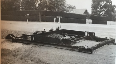
Photograph - Street Works, Studley Park Road, March 1934
Studley Park Road, like most streets in Kew, was originally a dirt road. Street works during the Great Depression included bituminising major roads in the district. This photograph of Council works originated in the City of Kew Engineers Department as a record of works undertaken. It was given to the collection by a Mrs Fisher in 1998.Well provenanced photograph of Council-funded public works in Kew during the Great Depression. Original sepia photographic positive of a drag used to spread bitumen in Studley Park Road, Kew.Typed reverse: "B4 / Kew C.C. / Drag spreader used for premixed material on Studley Park Road, showing end of strip just with spread, with unsurfaced work on left and completed section on right, March 1934"roadworks -- kew (vic.), street works -- kew (vic.), public works kew (vic.), studley park road -- kew (vic.), city of kew -- engineers department, city of kew -- public works -- great depression -- 1930s -
 Melbourne Tram Museum
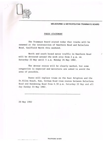
Document - Press Release, Melbourne & Metropolitan Tramways Board (MMTB), "Press Statement", Jun. 1982
Set of four MMTB Press Statements or Press Releases with MMTB letterhead. Photocopied onto A4 paper. 1. Renewal of tracks - Caulfield North - 20/5/1982. 2. Maintenance of railway crossing - Riversdale Road - 15/6/1982. 3. Maintenance of Bridge Rd and Church St Richmond - 1/6/1982 4. Maintenance work in Pascoe Vale Road, Moonee Ponds - 16/6/1982Item 4 has a handwritten note in ink "NB now half a "Grand Union" at Sydney Road & Moreland Rd"trams, tramways, mmtb, trackwork, road works, news broadcasts -
 Melbourne Tram Museum
Slide - Set of 7, John Webster, 17/10/1959 12:00:00 AM
Set of seven Colour slides, Kodak, brown cardboard of the removal of the Elsternwick Level crossing on 28-5-1960 .1 - looking down into he cutting through the old goods yard - has the platform being installed. .2 - X2 675 crossing the new bridge with the level crossing in the background. .3 - L103, to the city, route 4, with the conductor watching the trolley pole. Has an advert for white horse whiskey. .4 - W2 269, route 4 to Carnegie, on the level crossing. Has a building in the background, advertising Esquire car sales. .5 - A Tait train on the crossing no gates in operation. .6 - ditto, to Sandringham .7 - W6 965, route 4 to the City on the crossing. Has two railway hoardings in the background advertising BP Benzol petrol and Saunders Pure Malt extract and part of a sign for Penfolds. The tram has an advert for Porsche cars. Note the tram stop sign on the small post alongside the tram.Hand writing on rear in ink; .1 - 28-5-60 - Railway cutting for underpass at Elsternwick Vic. .2 - ditto, tram 675 on temporary tracks in Glenhuntly Road, Elsternwick Vic. .3 - tram 103 on temporary tracks in Glenhuntly Road, Elsternwick Vic. .4 - tram 269 on temporary tracks in Glenhuntly Road, Elsternwick Vic. .5 - Elsternwick station new crossing .6 - Temporary track Elsternwick Vic .7 - Tram 965 at temporary stop at Elsternwick Vic.trams, tramways, elsternwick, level crossings, railway squares, w2 class, l class, carnegie, south caulfield, glenhuntly rd, w6 class, vr -
 Victorian Interpretive Projects Inc.
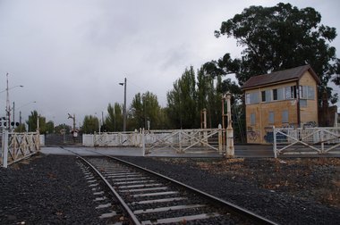
Photograph, Elaine Murphy, Ballarat Railway Gates, 03/05/2012
... Tracks ...Railway track running through the gates at Humffray Street (North) Ballarat. Signal box in foreground and Ballarat Station in the BackgroundRailway track going through gates at Humffray Street (North), Ballarat. Signal box on the right of photo, Ballarat station in background. railways, gates, building, signal box, lights, tracks, train, ballarat station, lines, road, rust, lights, ballarat, graffiti. -
 Mt Dandenong & District Historical Society Inc.
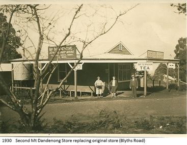
Photograph, Mt Dandenong Store, 1930
Image shows the Mt Dandenong Store and Post Office that replaced the former Post office and Store that was located on the corner of Old Coach and Farndons Roads. The store relocated following the opening of the new Main Road in 1926. The store pictured was on the corner of Helen Street and the Main Road. The image was taken in 1930. The photograph was taken by a member of the Dower family.Donated as a jpeg digital image that shows the Mt Dandenong Store on the corner of Helen Street and the Main Road in 1930. Two women and a man are standing at the front. Signs advertising the Store & Post Office, Age and Argus are clearly visible on top of the verandah.Front of image: 1930 Second Mt Dandenong Store replacing original store (Blyths Road)mt dandenong, post office, store, mt dandenong store, main road -
 Kew Historical Society Inc
Photograph, Stuart Tompkins Studio, Electricity Supply Poles, North Road, Ormond, 1965
Research provided by Stuart Tompkins Studio, Box Hill, into alternatives for median strip street lighting to be used in Burke Road, Kew. The photographers identified variants in different suburbs appropriate to Kew's needs.The series from which the photograph is drawn provides a snapshot by a commercial photographic studio of each named vicinity in 1965 as well as providing examples of public works infrastructure being commissioned by local government in the 1960s. The photos originally formed part of the Engineering Department's files in the City of Kew before being donated to the kew Historical Society.Electricity Supply Poles, North Road, Ormond, 1965. Electricity supply poles photographed for the Kew City Council by Stuart Tompkins Studio. The photograph of North Road, Ormond west of Jasper Road, looking east depicts wooden poles carrying two lamps in a median strip and with two on each side alternately. It was noted that the supply wires were from one side only. The poles were described as 3′ above ground and 11.25″ in diameter. The plan was to use this approach for Burke Road, Kew. [There are three copies of this photograph in the Collection.] Typed inscription on reverse: "Electricity Supply Poles. Photographed for Kew City Council 8/2/65. No.1 North Road - Ormond, west of Jasper Road, looking east. Wooden poles carrying two lamps in median strip and two on each side alternately just as is proposed for Burke Road, Kew. Supply wires from one side only. Poles 3' above ground 11 1/4" dia." Studio stamp: "Stuart Tompkins Studio. 547 Station Street, Box Hill. WX1439."stuart tompkins studio, street lighting, south road (moorabin) 1965, public infrastructure -- city of kew, city of kew -- engineer's department -
 Kew Historical Society Inc
Photograph, Stuart Tompkins Studio, Electricity Supply Poles, North Road, Ormond, 1965
Research provided by Stuart Tompkins Studio, Box Hill, into alternatives for median strip street lighting to be used in Burke Road, Kew. The photographers identified variants in different suburbs appropriate to Kew's needs.The series from which the photograph is drawn provides a snapshot by a commercial photographic studio of each named vicinity in 1965 as well as providing examples of public works infrastructure being commissioned by local government in the 1960s. The photos originally formed part of the Engineering Department's files in the City of Kew before being donated to the kew Historical Society.Electricity Supply Poles, North Road, Ormond, 1965. Electricity supply poles photographed for the Kew City Council by Stuart Tompkins Studio. The photograph of North Road, Ormond west of Jasper Road, looking east depicts wooden poles carrying two lamps in a median strip and with two on each side alternately. It was noted that the supply wires were from one side only. The poles were described as 3′ above ground and 11.25″ in diameter. The plan was to use this approach for Burke Road, Kew. [There are three copies of this photograph in the Collection.] Typed inscription on reverse: "Electricity Supply Poles. Photographed for Kew City Council 8/2/65. No.1 North Road - Ormond, west of Jasper Road, looking east. Wooden poles carrying two lamps in median strip and two on each side alternately just as is proposed for Burke Road, Kew. Supply wires from one side only. Poles 3' above ground 11 1/4" dia." Studio stamp: "Stuart Tompkins Studio. 547 Station Street, Box Hill. WX1439."stuart tompkins studio, street lighting, south road (moorabin) 1965 -
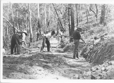 Halls Gap & Grampians Historical Society
Photograph - B/W, C 1920s
... Roads ...See r record 140 for historical information on the building of Mount Victory Road. Two of the men in the photo are Charles D'Alton and Fred Paasch, however it is not known which ones they are.Photo shows 4 men engaged in road building Two have picks, a third is using a shovel The fourth is chopping a treeMt Victory road in the the making 1920s Commencement of My Victory rod Charles D/Alton, Fred Paaschaccess routes, roads, access routes, road building -
 Melbourne Tram Museum
Document - Research Notes, H. S. McComb, development and timing of the "PMTT" - part 4, 1950's
Set of papers, handwritten concerning the development and timing of the "PMTT", Prahran and Malvern - about 40 sheets. Prepared by H. S. McComb - gives layout of the PMTT system, primarily of Burke Road, sketches of track layout, opening dates, sketches of various junctions, bridges, track miles, junctions, reconciliation of track lengths from various sources includes Glenferrie and Cotham Road, Balaclava Road, Hawthorn Road, Glenhuntly Road, Waverley Road and St Kilda Esplanade, Candy Corner. Items 2041 to 2052 within box 72.3 in a brown folder marked "PMTT" in red pencil.trams, tramways, pmtt, malvern, routes, track, surveys, glenferrie rd, cotham rd, balaclava rd, hawthorn rd, waverley rd, st kilda, candy corner -
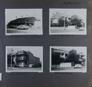 Glen Eira Historical Society
Album - Album page, Hawthorn Road, Circa 1972
This photograph is part of the Caulfield Historical Album 1972. This album was created in approximately 1972 as part of a project by the Caulfield Historical Society to assist in identifying buildings worthy of preservation. The album is related to a Survey the Caulfield Historical Society developed in collaboration with the National Trust of Australia (Victoria) and Caulfield City Council to identify historic buildings within the City of Caulfield that warranted the protection of a National Trust Classification. Principal photographer thought to be Trevor Hart, member of Caulfield Historical Society. Most photographs were taken between 1966-1972 with a small number of photographs being older and from unknown sources. All photographs are black and white except where stated, with 386 photographs over 198 pages. 23-29 Hawthorn Road Caulfield North are contributory buildings to HO14 Caulfield North and environs, Caulfield North - Heritage Precinct in the City of Glen Eira.Page 82 of Photograph Album with four landscape photographs of street views of two sets of properties on Hawthorn Road. Addresses are handwritten underneath each property.Handwritten: Hawthorn Road [top right] / 28-34 HAWTHORN ROAD 3 Sep 1972 [under top left photo] / 23-29 HAWTHORN ROAD [under top right photo] / 23-29 HAWTHORN ROAD 3 Sep [under bottom left photo] / 23-29 HAWTHORN ROAD [under bottom right photo] / 82 [bottom right] trevor hart, caulfield, hawthorn road, victorian, cars, terrace houses, cottages, streetscapes, caulfield north -
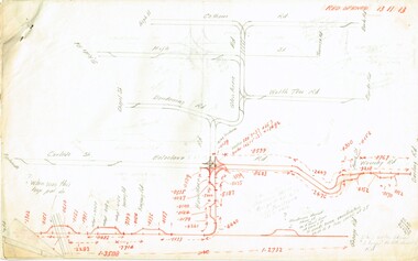
 Halls Gap & Grampians Historical Society
Map - Coloured
... Roads ...Background on Bridle Path up Stony Creek Gorge Pre 1840 C. B. Hall, squatter on Mokepilly Run 1841-1842, first European to discover the Fyans Creek valley, the entrance of which became known as Hall's Gap. He later recorded that he followed a number of tracks which he assumed had been made by the Aboriginies and described one as "leading up a wild romantic glen and over on to the source of the Glenelg River". This could well have been the route taken up Stony Creek gorge by the first timber-cutters in this part of the Grampians to the saddle between the Wonderland and Mt. Difficult ranges known as Valley Gap 1850s/60s Timber cutters and shingle splitters were reported to be moving into the eastern side of the Grampians and by the mid 1860s there were a number of families connected to the supplying of timber to Pleasant Creek living in the "Hall's Gap ranges". John Wakeham, the first store owner in Pleasant Creek in 1854, established a timer-mill in upper Stony Creek Gorge in the late 1850s. Wakeham is credited for the clearing and levelling of the first bridle-path up the gorge. 1870s By the mid 1870s the track had been extended over Valley Gap to the Victoria Forest (the upper region of the Victoria Valley). McKeon's bullock team was known to have hauled red gum from the Valley to Stawell in the late 1870s and the 1880s. 1880s In 1887 an article in the Pleasant Creek news describes the Stony Creek Gorge track as "being a ledge alongside the mountain range, formed in the early days with the aid of earth and timber, along which the bullock teams used to travel to Horsham and plains of the Wimmera beyond." 1890s Gold was discovered in the catchment area of Stony Creek and by the end of the 1890s a new track was built from "near the junction of Fyan's and Stony Creeks, up the gorge to the diggings settlement. The mining Department had paid L300 for its construction and, when completed, the track was "three miles and 30 chains in length, the side cuttings at the narrowest part being 10 feet between" and "the watercourses which cross the track at various points" having been "filled up with rocks rolled down the sides of the hills, and consequently there can be no damage caused by bushfires which destroyed the former wooden bridges erected on the old track to Wakeham's saw-mill, the remains of which are still to be seen at the side of the diggings" The article goes on to further describe the track as one which "can with ease travel with a two horse conveyance either up or down" and that the workmen engaged in the construction of the track would be attending "a ball that night at McKeon's farm near the mouth of the gap to celebrate the successful completion of the undertaking". 1900s At what time the bridle path was extended beyond Valley Gap to the Wartook basin on the Mt. Difficult Range has not yet been determined. However, it is known that, by the turn of the century, people were travelling between Halls Gap and the caretakers' residence at Wartook Reservoir along what was now known as the "Bluff Road. Wartook's embankment had been constructed in 1887 and at that time there was already a track from Rosebrook Station homestead (near the present day Wartook Pottery) to the reservoir. Philip Rose owned both Rosebrook and Wartook Stations from the mid 1840s to the late 1850s and had regularly leased the Wartook basin to Cobb & Co. to rest horses there. 1920s Following the war of 1914-1918, tourism really took off in the Grampians, and Halls Gap rapidly grew. People would travel as far as they could on the many tracks then hike to the many lookouts being discovered by local tour guides. This led to the need for access across the range so that horse riders and the increasing number of vehicles could travel between Horsham and Halls Gap. To this end, the Bluff Road was improved and extended on 1929 and at its opening in March, 1930, by Lady Somers it was renamed the Mt. Victory Road.Map of Mt Victory Road and othersaccess routes, mt victory rd, bridle path, roads -
 Otway Districts Historical Society
Photograph, Les Ogden, Crowes track being dismantled at ashpit, 1961, 1961
On the Colac-Beech Forest-Crowes railway line the section from Ferguson to Crowes was closed in December 1954, but reopened as far as Weeaproinah in January 1955. The section to Crowes, left to its own devices, was rapidly covered with vegetation which had to be cleared when rail recovery trains later ran. The track to Crowes was pulled up in 1961. Crowes track being dismantled at the ashpit ready for loading into NQR wagons. colac; beech forest; crowes: railway; -
 Marysville & District Historical Society
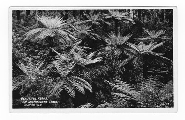
Postcard (item) - Black and white postcard, Valentine Publishing Co. Pty. Ltd, Beautiful Ferns, on Michaeldene Track, Marysville. V.25, 1923-1963
An early black and white photograph of tree ferns along the Michaeldene Track in Marysville in Victoria.An early black and white photograph of tree ferns along the Michaeldene Track in Marysville in Victoria. This walking track links the Steavenson River and the Taggerty Rivers and is a step back in time to Marysville's historic logging past. Sections of this mostly flat circuit follow old tramline alignments, which in places reveal the original timber sleepers on which the big logs were transported to the nearby sawmill. This postcard was produced by the Valentine Publishing Co as a souvenir of Marysville.VALENTINE'S POST CARD A GENUINE PHOTOGRAPHmichaeldene track, walking track, marysville, victoria, tree fern, steavenson river, taggerty river, logging -
 Kiewa Valley Historical Society
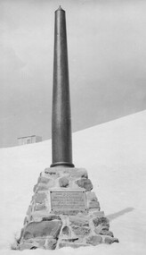
Photo: Memorial on the Staircase Spur Track, Mt Bogong
Mt Bogong is the highest mountain in Victoria. The Staircase Spur track to its top starts at Mountain Creek Road going through forest and continuing above the snow line to grass land. The weather can change very quickly with cloud and snow making conditions dangerous. Large sepia photo of the Memorial in snow on the Staircase Spur Track on Mt Bogong. The Memorial has a plaque attached: Sacred to the Memory / of Georgine Gadsden / Edward Neave Welch / John McRae / who perished here during a blizzard / about August 2nd 1943staircase spur memorial, mt bogong