Showing 127085 items
matching main-road
-
 Surrey Hills Historical Society Collection
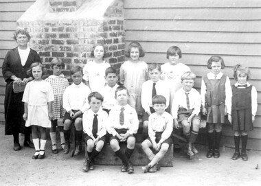
Photograph, Miss Susan Kelsall's school, Canterbury Road, Surrey Hills, 1925
Date is approximate. The teacher is presumed to be Miss Susan Kelsall; 3 of the children are identified as: Back row left: Thora Holmes Back row right: Gwen Evans and Betty Austin. Miss Kelsall was registered as a primary and music teacher in 1908. In 1919 she had a school at Wyclif Church in Norfolk Road. From 1924-1930 the school was in the hall, perhaps built for her, at 426 Canterbury Road, just west of Warrigal Road. This was demolished in 1985; a gum tree marked the spot.Black and white photo of a teacher holding a book and 3 rows of children in front of a weatherboard wall with a brick chimney protruding from the wall. The children are not in uniform although a couple of the girls are wearing tunics and all the boys are wearing ties. independent schools, schools, primary education, music, miss susan kelsall, miss gwen evans, miss betty austin, miss thora holmes, mrs betty harvey -
 Ringwood and District Historical Society
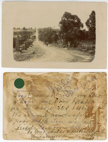
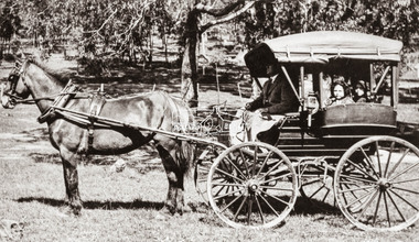
Photograph, Maroondah Highway Central, Ringwood. Warrandyte Rd looking North from Main Street, Ringwood. 1908
Black and white photograph reproduced from post card. Scene of road looking towards Loughnan Hill, Andrew Kennedy's orchard. Horse and cart in centre of photo, orchard to left of picture. (3 enlarged copies, 2 postcards, a clipping and 1 9x18.5 reproduction) Postcards with correspondence from N Blood, 2 original of the postcards with messages. First reads: "Trust you are well my dear and hope your poor Mater is no worse but better. We arrived home safely..poor little Tim was very tired. Love from all to your sister and mother..self. Your sincere friend, N. Blood" Second Reads: "Miss Hill. Cowes P.O.. 4/3/09 Dear Olive, come at once; I am on my last legs! Very pleased to hear that you have been enjoying yourself as well. Your mother had been very ill and Elvie has lost a stone weight; and ??? looks down in the dumps. Topsy killed canary this morning so I took Topsy for a walk! Had a bush fire up at home on 22 and 23rd Feb. No time to scribble more. Yours to a cinder. Bert." This postcard writing is overstamped J.B.McAlpin, Estate and Financial Agent. District Government Valuer Ringwood. It has a 1d Victorian Stamp affixed. Typed below photograph, "Warrandyte Rd. from Maroondah Hwy. looking north. Mullum Creek bridge in dip - 1908". -
 Greensborough Historical Society
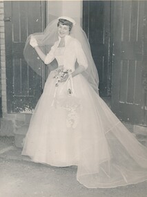
Photograph - Digital Image, Partington Family, Wedding of Faye Partington and Eric Fort 1957, 1957_
The marriage of Faye Partington to Eric Fort at the Greensborough Methodist Church, Main Street, 1957. Faye Partington.One of a series of Partington wedding photographs taken at the old Methodist Church.Digital copy of black and white photographpartington family, faye fort (nee partington) -
 Greensborough Historical Society
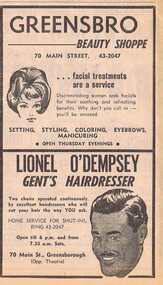
Advertisement - Digital image, Diamond Valley News, Greensbro Beauty Shoppe and Lionel Dempsey Gent's Hairdresser, 1964, 29/09/1964
Advertisement for Greensbro Beauty Shoppe and Lionel Dempsey Gent's Hairdresser, 70 Main Street, Greensborough 1964Digital copy of newspaper advertisement.main street greensborough, greensbro beauty shoppe, lionel dempsey mens hairdresser -
 Greensborough Historical Society
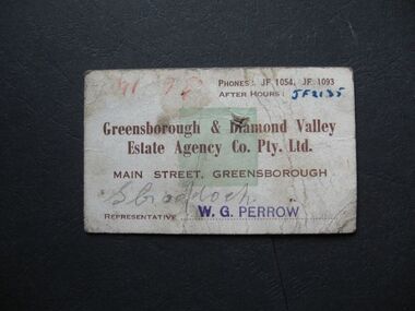
Business card - Digital Image, Greensborough And Diamond Valley Estate Agency, 1960, 1960s
Digital image of business card for Greensborough And Diamond Valley Estate Agency, Main Street, Greensborough 1960s.Part of a collection of miscellaneous historical images with a connection to the local area.Digital image of business card.Various notes and representative's name.main street greensborough, greensborough and diamond valley estate agency -
 Greensborough Historical Society
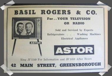
Advertisement - Digital image, Basil Rogers, 1960s
Advertisement in the local paper for Basil Rogers, television and radio sales and service of Main Street Greensborough 1960sPart of a collection of miscellaneous advertisements for businesses in Greensborough and surrounding areas.Digital copy of newspaper advertisement.main street greensborough, basil rogers -
 Kew Historical Society Inc
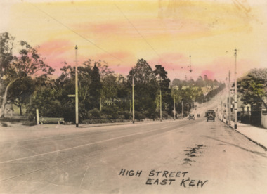
Postcard - High Street, East Kew, c.1927
High Street, Kew is the main Road in Kew. It was once also known as Bulleen Road, or Main Street. This section of the road is in Kew, although the narrow section on the right hand side of the photo is now Kew East. High Street progresses through a number of significant road junctions: beginning at Barkers Road; progressing through the intersection of Studley Park Road, Denmark Street and Princess Street at Kew Junction; branching left at the junction with Cotham Road; before reaching the junction with Valerie Street and Harp Road. It reaches its end at the junction of Burke Road, Kilby Road, Bulleen Road and High Street itself. An early photograph of this iconic Memorial that locates it in its context. Small, colorised real photo postcard of High Street, East Kew. Electric light poles line the road. Victoria Park is on the left and further on the horizon is the Boroondara General Cemetery.high street -- kew (vic.), victoria park, tram lines -- kew (vic.) -
 Ballarat Heritage Services
Photograph - Digital photograph, Lisa Gervasoni, Housing in Cotham Ward, Kew, 2017
Housing units in Cotham Road, Kewkew, housing, streetscape, archiecture -
 Surrey Hills Historical Society Collection
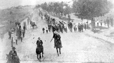
Photograph, Parade in celebration of King Edward VII's birthday, 1902
The parade was held in celebration of King Edward VII's birthday on 4 July 1902. This was the first public appearance of the German Band formed on 30 May 1902. The leading horseman is Mr Rowland Coe. He is followed by Mr George Robinson, a butcher of Canterbury Road. The man in the white hat is Mr Sam Kellett, businessman of Erasmus Street. Behind him on foot and partly obscured is Mr Alexander McNeill of the Surrey Family Hotel. Band master is Harry Pollard, painter and paper-hanger, and next to him is Constable Hill. The small boy in the sailor suit is Perc Venman of Essex Road and in the buggy near the footpath is Mr and Mrs William Maling. Information came from David Staig senior. Further research: William Saunders Maling, a son of John Butler Maling, was a builder who lived at 17 Balwyn Road, Canterbury. Rowland Coe, a butcher and son of James and Elizabeth Coe of Sunbury Crescent enlisted in AIF in WW1. He later lived at 233 Elgar Road, Box Hill. William Percival Reginald (Perc) Venman was born in Surrey Hills in 1894; he died in Surrey Hills in 1951 and lived at 27 Essex Street for much of his life. He and his wife are buried in Box Hill Cemetery. The identity of Sam Kellett of Erasmus Street is questioned. Edward Kellett built 'Yielma' in Erasmus Street but was deceased by 1902. He had 3 sons: Edward Allan (1854-1932); George Henry (1858-1921) and William John (1865-1945).Black and white photo of a number of men on horses leading a parade down Station Street (Windsor Crescent) to Union Road. Street trees on the RHS are mature whilst the ones on the LHS look to be newly planted. They have wooden guards around them. The area to the left is blurry but would be the railway line and station surrounds. Roads are well formed with bluestone channels.parades and processions, bands, german band, windsor crescent, william saunders maling, mrs hannah maling, miss hannah miller, constable hill, perc venman, george robinson, sam kellett, alexander mcneill, rowland coe, harry pollard, william percival reginald venman -
 Eltham District Historical Society Inc
Negative - Photograph, P.A. Cooper with the Cooper family Waggonette at "Evansdale," Sherbourne Road, Greensborough, 1913
P.A. Cooper with the Cooper family waggonette and his two daughters at "Evansdale" on Sherbourne Road at Greensborough in 1913. Sherbourne Road is visible in the background. Marjorie North (nee Cooper) was one of his daughters. Copy of the original image contained in a photo album belonging to Marjorie North.Roll of 35mm colour negative film, 1 strip (3 frames) - copy of original photo in private album Colour print of negativeAgfa XRG 200greensborough, evansdale, p.a cooper, sherbourne road, horse drawn vehicles, marjorie north, phaeton, wagonette -
 Wonga Park Community Cottage History Group
Photograph - Colour, Pupils opposite school on Dudley Road in 1988
This photo of 4 pupils in Dudley Road opposite the Wonga Park School is a 1988 version of the photo of 4 pupils in Dudley Road opposite the school taken in 1912 The 1988 pupils are from left, Rowan Allport, Lauren Windsor, Sarah Greenwood-Smith, Ashley Drew -
 Wonga Park Community Cottage History Group
Photograph - Colour, Close up of Pupils opposite school on Dudley Road in 1988
This photo of 4 pupils in Dudley Road opposite the Wonga Park School is a 1988 version of the photo of 4 pupils in Dudley Road opposite the school taken in 1912 The 1988 pupils are from left, Rowan Allport, Lauren Windsor, Sarah Greenwood-Smith, Ashley Drew -
 The Beechworth Burke Museum Research Collection
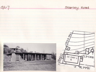
Card (Series) - Index Card, George Tibbits, Stanley Road, Beechworth, 1976
George Tibbits, University of Melbourne. Faculty of Architecture, Building and Town & Regional PlanningIndex system that support the research for Beechworth : historical reconstruction / [by] George Tibbits ... [et al]Arranged by street names of BeechworthEach index card includes: street name and number of property, image of property, allotment and section number, property owners and dates of ownership, description of the property according to rate records, property floor plan with dimensions.beechworth, george tibbitsbeechworth, george tibbits -
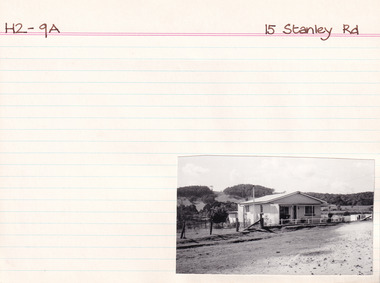 The Beechworth Burke Museum Research Collection
Card (Series) - Index Card, George Tibbits, 15 Stanley Road, Beechworth, 1976
George Tibbits, University of Melbourne. Faculty of Architecture, Building and Town & Regional PlanningIndex system that support the research for Beechworth : historical reconstruction / [by] George Tibbits ... [et al]Arranged by street names of BeechworthEach index card includes: street name and number of property, image of property, allotment and section number, property owners and dates of ownership, description of the property according to rate records, property floor plan with dimensions.beechworth, george tibbitsbeechworth, george tibbits -
 Melbourne Tram Museum
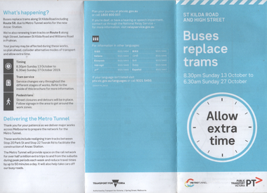
Pamphlet, Public Transport Victoria (PTV), "Buses replace trams - St Kilda Road and High Street", Oct. 2019
Pamphlet - "Buses replace trams - St Kilda Road and High Street" - part of the Metro tunnel project works, Oct 2019 affecting mainly route 6 trams along with St Kilda Road routes. Includes a map of the work zone and bus replacement services.Demonstrates a passenger information document about trackworks.Pamphlet - 6 fold DL printed trams, tramways, st kilda road, high st, route 16, metro tunnel, trackworks -
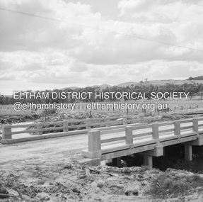
 Eltham District Historical Society Inc
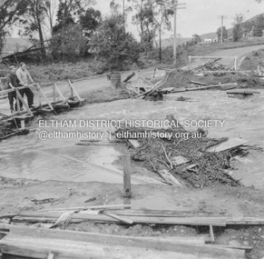
Album - Photograph, J.A. McDonald, Heidelberg-Kinglake Road, 18 Oct. 1956
Yarra Glen-Glenburn Road Jehosophat Creek 18th October 1956Record of various Shire of Eltham infrastructure works undertaken during the period of 1952-1962 involving bridge and road reconstruction projects, sometimes with Eltham Shire Council Project Reference numbers quoted. It was during this period that a number of significant improvements were made to roads and new bridges constructed within the shire that remain in place as of present day (2022). In many situations, the photos provide a tangible visible record of infrastructure that existed throughout the early days of the Shire. The album was put together by or under the direction of the Shire Engineer, J.A. McDonald.infrastructure, shire of eltham, bridge construction, heidelberg-kinglake road, road construction, 1956-10-18, flood damage, floods, floodwater, jehosophat creek, yarra glen-glenburn road -
 Eltham District Historical Society Inc
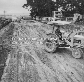
Album - Photograph, J.A. McDonald, Kangaroo Ground-Warrandyte Road, c. Sep. 1955
Relocation Guthries Kangaroo Ground-Warrandyte Road September/October 1955Record of various Shire of Eltham infrastructure works undertaken during the period of 1952-1962 involving bridge and road reconstruction projects, sometimes with Eltham Shire Council Project Reference numbers quoted. It was during this period that a number of significant improvements were made to roads and new bridges constructed within the shire that remain in place as of present day (2022). In many situations, the photos provide a tangible visible record of infrastructure that existed throughout the early days of the Shire. The album was put together by or under the direction of the Shire Engineer, J.A. McDonald.infrastructure, shire of eltham, bridge construction, road construction, 1955-09, bulldozer, graders, kangaroo ground-warrandyte road, l.r bassett pty ltd -
 Eltham District Historical Society Inc
Album - Photograph, J.A. McDonald, Kangaroo Ground-Warrandyte Road, c. Sep. 1955
Relocation Guthries Kangaroo Ground-Warrandyte Road September/October 1955Record of various Shire of Eltham infrastructure works undertaken during the period of 1952-1962 involving bridge and road reconstruction projects, sometimes with Eltham Shire Council Project Reference numbers quoted. It was during this period that a number of significant improvements were made to roads and new bridges constructed within the shire that remain in place as of present day (2022). In many situations, the photos provide a tangible visible record of infrastructure that existed throughout the early days of the Shire. The album was put together by or under the direction of the Shire Engineer, J.A. McDonald.infrastructure, shire of eltham, bridge construction, road construction, 1955-09, kangaroo ground-warrandyte road -
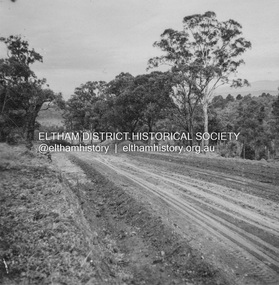
 Eltham District Historical Society Inc
Album - Photograph, J.A. McDonald, Kangaroo Ground-Warrandyte Road, 1955
Kangaroo Ground-Warrandyte Road Showing deviation old location on leftRecord of various Shire of Eltham infrastructure works undertaken during the period of 1952-1962 involving bridge and road reconstruction projects, sometimes with Eltham Shire Council Project Reference numbers quoted. It was during this period that a number of significant improvements were made to roads and new bridges constructed within the shire that remain in place as of present day (2022). In many situations, the photos provide a tangible visible record of infrastructure that existed throughout the early days of the Shire. The album was put together by or under the direction of the Shire Engineer, J.A. McDonald.infrastructure, shire of eltham, bridge construction, road construction, kangaroo ground-warrandyte road, 1955 -
 Eltham District Historical Society Inc
Negative - Photograph, J.A. McDonald, Old Healesville Road, Sep 1959
Paul Creek Road Prestressed slabs September 1959 Bridge finishedRecord of various Shire of Eltham infrastructure works undertaken during the period of 1952-1962 involving bridge and road reconstruction projects, sometimes with Eltham Shire Council Project Reference numbers quoted. It was during this period that a number of significant improvements were made to roads and new bridges constructed within the shire that remain in place as of present day (2022). In many situations, the photos provide a tangible visible record of infrastructure that existed throughout the early days of the Shire. The album was put together by or under the direction of the Shire Engineer, J.A. McDonald.infrastructure, shire of eltham, bridge construction, 1959-09, old healesville road, paul creek road -
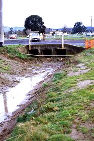 Greensborough Historical Society
Slide - Photograph, John Ramsdale, Near Plenty Road South Morang: Slide 53, 1990s
Photograph shows drain and culvert near Plenty Road South Morang.Part of the John Ramsdale collection of slides and audio visual material.Colour photograph scanned from slide.No maker's marks. No caption on slide.plenty road south morang -
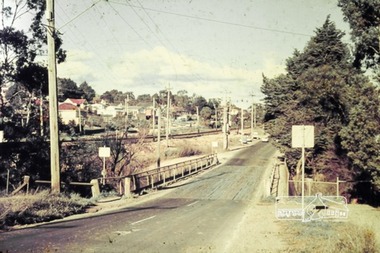 Greensborough Historical Society
Photograph - Photograph - Digital Image, Para Road bridge 1960s, 1960s
A photograph of the Para Road bridge 1960s, with rail line running parallel. Digital copy of colour photograph.para road greensborough, para road bridge -
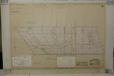 Greensborough Historical Society
Planning document, Subdivision Plan #1009. Corner Allumba Drive and Beales Road Greensborough, 1981_
Plan of Subdivision of land at corner of Allumba Drive and Beales Road Greensborough.An example of hard copy subdivision plans from the Greensborough area. Mainly from the Shire of Diamond Valley era (1964-1994).Plan (2 sheets) mounted on heavy card.Stamped and handwritten Council permissions, dates and other details.subdivision plans, allumba drive, beales road -
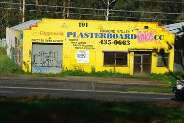 Greensborough Historical Society
Photograph - Digital image, Marilyn Smith, Diamond Valley Plasterboard Factory at 191 Para Road Montmorency, 17/09/2014
Diamond Valley Plasterboard factory 2014 (now demolished) in Para Road.Digital copy of colour photographdiamond valley plasterboard, para road greensborough -
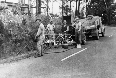 Eltham District Historical Society Inc
Photograph, Whittlesea-Kinglake Road Patrol Gang, April 1961
Mrs. McMinn, Kinglake and Country Roads Board, Neg. No. 60-1034This photo forms part of a collection of photographs gathered by the Shire of Eltham for their centenary project book,"Pioneers and Painters: 100 years of the Shire of Eltham" by Alan Marshall (1971). The collection of over 500 images is held in partnership between Eltham District Historical Society and Yarra Plenty Regional Library (Eltham Library) and is now formally known as the 'The Shire of Eltham Pioneers Photograph Collection.' It is significant in being the first community sourced collection representing the places and people of the Shire's first one hundred years.Digital imagesepp, shire of eltham pioneers photograph collection, kinglake, whittlesea-kinglake road, road gang -
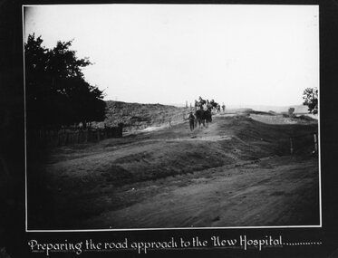 Stawell Historical Society Inc
Photograph, Preperation of the new approach road to the Stawell Hospital
Stawell Hospital Workmen on New Hospital Site preparing the road approach.stawell hospital -
 Stawell Historical Society Inc
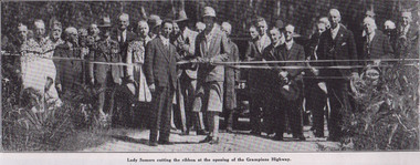
Photograph, Stawell “Weekly Times” article about the Opening of Mt Victory Road March 22nd 1930
“Weekly Times” Opening of Mt Victory Road March 22nd 1930stawell -
 Stawell Historical Society Inc
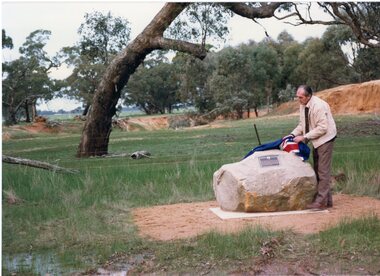
Photograph, Major Mitchell Trail Plaque At Wal Wal on the Stawell to Warracknabeal Road
Major Mitchell Trail Plaque At Wal Wal on Stawell to Warracknabeal Roadstawell -
 Stawell Historical Society Inc
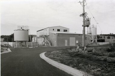
Photograph, Grampians Wimmera Mallee Water Purification Plant in Crowlands Road
Grampians Wimmera Mallee Water Purification plant. Crowlands Road Stawellgrampians water supply -
 Melton City Libraries
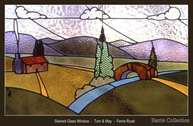
Decorative object, Stained glass window- Ferris Road, Unknown
Tom and May Barrie lived on the family farm at Ferris Road Melton. Window from the Barrie family farmlandscapes of significance