Showing 10881 items
matching land
-
 Eltham District Historical Society Inc
Photograph, Fay Bridge, Remains of apple orchard near the Diamond Creek, Wattle Glen, 11 October 2018
The newly constructed Diamond Creek Trail from Diamond Creek to Wattle Glen completed in February 2021 winds past these apple trees that possibly lined the entrance to the Greenhills property From Jean Verso, Nillumbik Historical Society, 15 April 2021 William Wandless Herbert bought the surrounding 100 acres in 1852. He was a native of Northumberland and the Scottish Borders who arrived in Melbourne in 1847. The house on the top of the mound would have been built not long after he bought the land; the farm was named "Greenhills". He married Elizabeth Wilson, daughter of John Wilson who had been in Diamond Creek since about 1846. Their first child was born in 1854 so there would be some form of dwelling from about that time. They had eight children who all survived to a good age. His will describes the house as part stone and part wood and of four rooms. Nillumbik Historical Society (NHS) believe it was one of the earliest if not the earliest house, in this part of the district. The remains of the stone house foundations are on top of the mound (photos on the VHD page) and the barn walls are on the north and to the east side of the mound. NHS is not sure how much or which part of the surrounding area was covered by the barns but they were large enough to hold dances after the race meetings that were held in the late 1880's on the adjacent creek flats. It would make sense with the lay of the land that they covered some of the ground to the north and east and used for farm storage, packing sheds for their apple and pear orchards and also for supporting the Nillumbik Gold Mine the family worked to the north up the gully. The path that comes down the gully and runs into the trail goes past the mine site which was on the west side of the gully a couple of hundred metres up from the flats. Heritage Victoria link for the site - https://vhd.heritagecouncil.vic.gov.au/places/12203fay bridge collection, 2018-10-11, diamond creek, diamond creek trail, elizabeth wilson, greenhills, wattle glen, william wandless herbert, apple trees -
 Sunshine and District Historical Society Incorporated
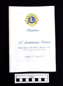
Booklet (2013), LIONS CLUB of SUNSHINE 60th Anniversary Dinner, 10 May 2013, 2013
On 12th May 1953 a meeting was arranged by the Lions Club of Footscray, and was held at the home of Bill Harvey in Sunshine, with the intention of forming a club in the Sunshine area. The first official luncheon was held on 3rd June 1953 at the Sunshine Town Hall and was attended by representatives from Melbourne, Footscray and Essendon Clubs. After the membership reached 25 the Lions Club of Sunshine was Chartered on 21st July 1953, and became the 5th Club in Victoria and the 17th in Australia. Over the years the club raised funds through various activities to provide charitable donations to organisations, people, and disaster areas, as well as to purchase house and land for a Senior Citizens Club. It became necessary to sell the house and land years later. The Lions Club also contributed to the Sunshine Swimming Pool which was opened in December 1960, and was welcomed by the children of Sunshine. Some of the activities to raise funds included Guy Fawkes bonfire nights, rodeos, paper and bottle drives, jumble sales,Tivoli Gala Nights, car raffles, and sausage sizzles. Over the past 10 years the Sunshine Lions have put in thousands of hours of work, and have disbursed in excess of $200,000 for charitable purposes. As well as supporting overseas projects and natural disasters, the Lions have continued their community work. Funds have been donated to care providers such as the Mercy Hospice and Scope, and also used to provide Christmas hampers and dinners, and for underprivileged children to have holidays. Some of the organisations that have recently received funds were Helping Hands Across the Pacific, Gellibrand Services, Royal District Nursing Service, and the Sunshine Mission. During 1960/61 the club membership reached a record 58, however at the time of the 60th Anniversary dinner the membership was 17, three of which were in their seventies and 3 in their eighties. The above brief historical information was sourced from the 60th Anniversary Dinner booklet.This booklet is significant because it contains an 11 page summarised historical record of the 60 years of activities of the Lions Club of Sunshine. It also contains an Honour Roll of past members and of members who received awards, as well as the names of the 61 people who served as Club Presidents from W.T. Harvey (1953-54) to P. Green (2012-13). The booklet can be used as a starting reference source for anybody seeking information about the Lions Club of Sunshine Inc.White paper booklet of 20 pages with blue printing and a blue and yellow Lions International emblem on the front cover. The booklet contains the dinner Menu and the Programme for the evening, as well as a summary of the 60 years of activities of the LIONS CLUB of SUNSHINE. It also features the names of the 61 Club Presidents, the members who received awards, and an Honour Roll.LIONS L INTERNATIONAL / Sunshine / 60th Anniversary Dinner / Italia Room, Club Italia Sporting Club 128-152 Furlong Road, North Sunshine / Friday 10th May 2013lions club of sunshine, 60th anniversary dinner, lions sunshine presidents 1953-2013, lions sunshine honour roll, historical activities of lions sunshine -
 National Wool Museum
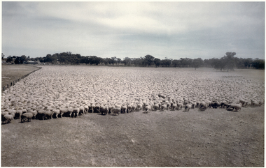
Photograph, Puckapunyal - 75,172 Sheep for Shearing, 1988
Banjo Paterson once wrote, ‘The musterers are fetching them a hundred thousand strong’. Well, not quite 100,000 strong, but there are 75,172 mixed age Riverina-bred merino wethers in this mob mustered for shearing on January 22, 1988. The sheep were owned by the Mountjoy family from Geelong Victoria and were running on Puckapunyal Army Base near Seymour in Central Victoria on which the family held the grazing lease. Contractor for the shearing, Jim Walker, Avenel, Victoria, former Australian shearing team captain in 1974-75 and 1978-79, recalls there were up to 21 shearers in his team waiting for the red eyes to arrive despite the mid-summer heat of up to 38°C and the blinding dust on windy days. Jim Walker thinks there may also have been some sheep in the mob from Portland Downs and Isis Downs near Isisford in Central Queensland. The biggest shearing he did at ‘Pucka’ was 87,087 shorn in 1988. The ‘Pucka’ base was established during WW1. During the Second World War the Second Australian Imperial Force trained there as well as the US Army 41st Infantry Division. It was also home to the 1st Armoured Regiment from 1949 until 1995. During the 1950s up to 4000 national servicemen at any given time were training there. In the 1980s the Army undertook a major 60,000-acre land rehabilitation programme as decades of heavy use had led to serious degradation. By 1988 when the photo was taken, further land acquisition had increased the area to just under 100,000 acres, 43,000 of which is still bush country. There are no sheep there now, and the old shed was bulldozed and burnt. There are thousands of kangaroos which of course don’t need to be shorn and would be hard to muster and hold for a similar photo. Colour photograph, 75,172 merino wethers, mustered for shearing at Puckapunyal in 1988.shearing merino sheep, mountjoy, mr dale - worungalla pastoral co., shearing, merino sheep -
 Surrey Hills Historical Society Collection
Photograph, Parer family portrait
Members of the Parer family began arriving in Australia from 1852. By the 1890s several had settled in Surrey Hills and Box Hill. Identification is as follows: Back L to R: Phillip ( ), Stephen, Joseph, Francis. Front L to R: John, Tici, Eulalia, Tia. Phillip lived at 'Monserrat' in Mont Albert Road (land later subdivided so that house was renumbered as a Weybridge Street address. Stephen was was the youngest child of Antonio and Josefa Parer. He left for Australia when he was 17 years old and landed in Melbourne in 1888 and went straight to work at Parers’ Crystal Palace for his brother Francis. Stephen preferred the outdoors and went to work on the family market garden in Box Hill. Joseph was the first Parer to arrive in Australia, in 1855. He and his brother Francis created the Parer dynasty in Australia, bringing all the family members from Spain and offering them work in their hotels. Francis Parer was born in Alella in 1836 and left for Australia when he was 17. In partnership, he commenced a business of general produce dealers in Little Bourke Street. He later entered the hospitality business buying in partnership the ‘Spanish Restaurant’ on Elisabeth Street and later, the Victoria Restaurant on Bourke Street with his brothers. In 1870 he purchased 40 acres of land at Box Hill at £15 per acre. The property became a famous market garden where he grew all kinds of vegetables and orchards. It is believed the first tomatoes in Australia were grown there. Juan or John lived in 'Gerona' in Weybridge Street. Eulalia Parer married Marcus Clota at Alella on 9 September 1867 and came to Australia in 1876. They lived in Guildford and Union Roads. Tia Marieta married and lived in Guildford Road. There are many members of the family buried in Box Hill Cemetery. Black and white formal studio portrait of 8 members of the Parer family mounted on brown board. There are 4 men standing and one man and 3 women seated.White paper label stuck to rear: "THE ORIGINAL PARER FAMILY WHO SETTLED IN AUSTRALIA - 1852. / Photograph with compliments of SANS family."phillip parer, stephen parer, box hill cemetery, joseph parer, francis parer, john parer, tici parer, eulalia parer, tia parer, "monserrat" -
 Wodonga & District Historical Society Inc
Photograph - Stonleigh, Wodonga
Stonleigh is one of Wodonga’s earliest buildings and stands on land granted to Daniel Rhodes in 1854, in one of the first land sales conducted in Wodonga. The building commenced soon after with the stone walls being 18 inches (46cm) thick. It was a four-room granite rubble stone building with central door and a window on either side, with a separate kitchen, as was typical of the worker's cottage of the day. The original roof would have been shingles but it was replaced with corrugated iron. It passed through several owners including Paul Huon in 1858. Peter Tenner, a farmer and vigneron took over in 1866 when it was described as “built of stone and having a cellar and a detached kitchen plus outside toilet, and a shed or two.” In the late 1880’s it was owned by William Smith who had come to Wodonga as a missionary for the Presbyterian Church and who, together with John Whan, storekeeper, was instrumental in building the Presbyterian Church nearby. Between 1890 and 1910 further buildings were added, consisting of double brick walls, two bedrooms, kitchen, laundry with brick and copper, bathroom and side verandah. William Smith established Wodonga Cordage Works in the Stonleigh buildings. The front room of the house was the display room for the business which manufactured and sold fishing lines, various types of cordage and water bags, the latter being of hand-sewn canvas. After 1954 Stonleigh became a bottle depot and bottle museum under ownership of Ramon Porta. At one stage he had over 50,000 bottles on display. In 1991 it was purchased by Mark Fraser, a cabinet maker, who made extensive renovations at the rear of the premises and internally, but left the façade untouched. Over recent times, Stonleigh was the home of several business including a florist, a patchwork maker and a café. Stonleigh was sold in 2021 and is now a private residence.These images capture one of Wodonga's oldest buildings.A series of photos, both colour and black and white, showing the building "Stonleigh' at different periodsstonleigh wodonga, old buildings wodonga, wodonga businesses, wodonga pioneers -
 Surrey Hills Historical Society Collection
Photograph, 6a Thistle Street, Surrey Hills, 1924
One of the oldest homes in Surrey Hills. The photo was taken in 1924 when the property was purchased by Mr John Francis Evans, father of Mrs Lillian Austin. The Evans family came from Gembrook. John Evans was born in Wales; he and his wife Mary had 3 children, 2 daughters and one son. Mary Evans pre-deceased her husband, who died on 23 October 1924 at Hillsborough, 6A Thistle Street. The first owner of the property was Mrs Rachel Sweetnam (nee Lewis) who married Thomas Edward Sweetnam on 24 September 1884 at St John's Church, Camberwell. REF: THE ARGUS 4 Oct 1884 Thomas second eldest surviving son of Matthew Sweetnam married to Rachel (Ray) third eldest daughter of Captain T.D. Lewis, Culm Haven, Camberwell. Thomas was active in land sales and variously described as a land agent, real estate agent and auctioneer. The property - Hillsboro or Hillsborough - was originally a house on a farm of 10 acres owned by her. It became 6A Thistle Street. According to the Alan Holt property register Rachel Sweetnam owned the property prior to 1890 and a family tree on Ancestry.com has that it was owned by her in c1886. It is likely that at this stage the property was an investment rather than the Sweetnam's family residence. Other property owners or residents are: 1890 Selina Gaylor 1900 Stephen Pullen 1910 William Murray (draftsman) 1920 George C Hughes 1930 Arthur Leslie Austin (tram driver) 1980 Mrs Lillian Evelyn Austin Lillian Austin died on 19 August 1983 and the property was sold that year for $87,000. The house is still extant (January 2025). Note that we also have material / photos regarding George Hughes and family.Black and white photo of a timber home with brick chimneys and a (?) corrugated iron roof. There are sheds and outbuildings attached to the house. The garden looks untended. In the background a mature eucalypt tree can be seen.houses, hillsboro, timber houses, mrs lillian austin, hillsborough, selina gaylor, stephen pullen, william murray, george hughes, arthur austin, john francis evans, thistle street -
 Eltham District Historical Society Inc
Document - Report, Paul Jerome, Advisory Committee on a Proposed Convenience Centre and an Alternative Shire Proposal - Eltham Gateway Community Precinct Concept Plan - 895 Main Road Eltham, October 1997
On 15 December 1994 the former Shire of Eltham ceased to exist following the Liberal Kennett Government local council amalgamations. A new Nillumbik Shire Council was established with unelected commissioners appointed. That Council sold the former Eltham Shire Council Offices and land at 89S Main Road Eltham to Dallas Price Homes Pty. Ltd. the sale being conditional upon the granting of a planning permit for a petrol station/convenience store, fast food and video outlet. The sale was conditional that if the permit was not granted by 30 August. 1997, the contract could be avoided by either the purchaser or the vendor. The proposed development consisted of a petrol station with undercover fuelling facilities, convenience shopping, a drive through service facility for fast food, an 80 seat cafe, automated banking, a children's play area and retail space. In addition, the proposal included a 200 square metre community facility for Council use, provision of on site carparking over 2 levels for 83 vehicles, and advertising signage. An Advisory Committee consisting of Dimitry Reed and Margaret Pitt was appointed under Section 151 of the Planning and Environment Act 1987 to hear submissions on the proposal to develop the land at 895 Main Road Eltham, the site of the former Eltham Shire Offices. In September 1996, two applications were made by Contour Consultants Australia Pty Ltd on behalf of Dallas Price Homes Ply Ltd, to Nillumbik Shire Council. After extensive notification, the Council received 213 objections and a petition of over 1400 signatures. On October 9, 1996, Nillumbik Shire Council issued Notices of Decision to Grant Permit on Applications number 96/03376 and 96/0377 for the use and development of the land as a convenience Centre consisting of a petrol station, convenience store, cafe/takeaway food premises, a retail facility and a community facility, with associated advertising signs. Objectors to the proposals lodged Planning Appeals number 96/40724 and 96/40812 with the Administrative Appeals Tribunal on November 1, 1996. The grounds of appeal can be summarised as: inappropriate development, insufficient carparking, traffic and access issues, unsatisfactory design, inadequate permit conditions, the proposal being out of character with the area. and being contrary to the purpose and orderly development of the Eltham Town Centre, excessive noise, lack of consultation and unsuitable signage. On November 13, 1996, the Minister for Planning and Local Government directed the Registrar of the Administrative Appeals Tribunal. under Section 41 (1) (a) of the Planning Act 1980, to refer the Appeals to the Governor in Council for determination without a hearing or recommendation by the Tribunal. The Minister for Planning and Local Government called in the Appeals as he considered that they raised major issues of policy relating to the facilitation of development in accordance with the objectives set out in Section 4 of the Planning and Environment Act 1987, and that determination of the Appeals could have a substantial effect on the achievement of these planning objectives. The Minister required the Advisory Committee to consider the planning merits of the proposed use and development, and to address the issues raised in the objections. The Advisory Committee was required to produce a report providing: • The Committee's response to the matters detailed; • Relevant supporting information for the Advisory Committee's recommendation; and • A description of the proceedings conducted by the Advisory Committee and a list of those consulted or heard by the Committee. In March 1997, elections were held in the Shire of Nillumbik and the view of the new Council to this proposal differed from the view held by the earlier Council Hence the Submission made to the Committee by the Shire was against the decision by the Shire of Nillumbik to issue the Notices of Decision to Grant a Permit. The Recommendations of the Advisory Committee were: i. The cafe and take away food premises are as of right uses and are therefore allowable, but that shop and petrol station are unacceptable uses. A community facility is a discretionary use and is acceptable. ii. A development of the type and scale proposed is totally inappropriate for this land and that the Applications number 96/03376 and 96/0377 for the use and development of the land as a convenience Centre consisting of a petrol station, convenience store, café/takeaway food premises, a retail facility and a community facility, with associated advertising signs, be refused. iii. The land should be rezoned for public purposes and should remain in the community's ownership for community use. Following this, the Minister for Planning and Local Government, the Hon. Robert Maclellan, appointed Mr. Paul Jerome as an Advisory Committee under section 151 of the Planning and Environment Act 1987 to consider a Convenience Centre and an alternative proposal by Iha Shire of Nillumbik being the Eltham Gateway Community Precinct Concept Plan for the site of the former Shire of Eltham municipal offices at 895 Main Road, Eltham. In summary, the terms of reference for the Advisory Committee required it to: • consider the merits of the Council proposal • examine the merits of both proposals in terms of net community benefit • address the report of the previous Advisory Committee on the Convenience Centre proposal The Advisory Committee inspected the site and considered all the material before It including submissions made by all parties to the previous Advisory Committee and correspondence received by the Department of Infrastructure both before and after that Committee submltted its report. The Advisory Committee also held discussions with the following people: • Cr. Robert Marshall • Cr. Margaret Jennings • Cr. Lex de Man • Mr. Dallas Howgate of Dallas Price Properties, also Dallas Price Homes • Mr. Barry Rochford, CEO, Shire of Nillumbik • Ms. Yvonne Rust, Planning Officer, Shire of Nillumbik • Mr. Gregory Burgess, Architect of the Eltham Library and of Council’s Community Precinct Concept Plan • Mr. Jim Connor representing Mrs Thelma Barkway of the Eltham Senior Citizens Club Having considered all the material before it, the Committee arrived at two basic conclusions. First, the DPP proposal should be rejected because, on its merits, It does not sufficiently satisfy the requirements of the planning scheme which is a statutory document. The planning scheme requires that, before making a decision on the permit applications for the DPP proposal, a range of matters must be considered. It follows that consideration of these matters should Influence the decision. These matters include local policies relating to character and amenity. In particular, these policies seek • to conserve and enhance the bushland/country atmosphere, artistic heritage and strong sense of community of the Eltham Town Centre by ensuring that the design and height of any new development is sympathetic to existing buildings • to achieve a pleasing physical environment within the Eltham Town Centre by encouraging a high standard of architecture and urban design • to encourage Improvement to pedestrian amenity through such facilities as open and shattered rest areas and meeting places, crossing facilities, pedestrian arcades, pedestrian links to car parks and pedestrian weather protection • to reduce conflict between vehicular traffic and pedestrian flows, and • to encourage pedestrian thoroughfares It is submitted, as set out In the main body of this report, that the DPP proposal fails substantially to meet these policies and In so doing does not merit the exercise of discretion In Its favour with the Issuing of a permit. This finding is not offset by the investment and employment attributes of the proposal. They do not override the need to comply with the planning scheme. Second, the Council proposal, on Its own merits, substantially meets all statutory requirements applicable to this site with a possible reservation about car parking and traffic management which need further definition and assessment as the concept is refined. The Council proposal, however, has a serious weakness in that Its financial viability has not been adequately tested. The Committee refers to 'financial' rather than 'commercial' viability in recognition that Council owns the land and may enter into a range of agreements and partnerships to realise its concept some of which may be truly commercial and some of which may involve an element of subsidy arising from Council's involvement as a public body acting on behalf of its community. The Committee concludes that Council should be given the opportunity, within a reasonable timeframe to establish the financial feasibility of its concept and should develop a strategy for the future of Its land asset at 895 Main Road in the event that Its concept for the site cannot be realised. 895 main road, advisory committee, dallas price homes, eltham, eltham shire office, nillumbik shire council, planning application, administrative appeals tribunal -
 Eltham District Historical Society Inc
Photograph - Digital Photograph, Alan King, St Margaret's Anglican Church, Pitt Street, Eltham, 30 January 2008
St Margaret’s Church of England was officially opened on December 12, 1861. It is the oldest intact church building in Eltham. At the time it was known as Christ Church until its consecration in 1871, when it was completely free of debt (£1,700 for the church and parsonage) despite the district’s poverty. This was largely due to the free labour and materials, including locally made bricks donated by local artisans and others. The church is historically significant because it is the oldest church in the former Shire of Eltham and has associations with the philanthropist and founder of Brighton, Henry Dendy (who donated the land on which the church is built), the architect Nathaniel Billing and the prominent local builder, George Stebbing. The church is architecturally and aesthetically significant because it is constructed in the Gothic Revival style with several stained-glass windows of various dates and is also a very early use of polychromatic brickwork in Victoria. Billing was one of the first Melbourne architects to employ polychromatic brickwork and an important early architect. The rear wall was intended to be temporary. A major feature of the design is the large buttresses with long, steeply graded upper faces. The overall design is well proportioned with the surface brick patterns relieving an otherwise austere design. The church is spiritually and socially significant because it has been an important place of worship for the people of Eltham for almost 150 years. The land on which the buildings stand was donated by Henry Dendy. Dendy arrived in Melbourne in 1841 after purchasing in England eight square miles at Brighton under the system of "special surveys". After this land passed out of his hands, Dendy moved about Victoria, visited England, then returned to settle in Eltham where he purchased a flour mill. Dendy chaired the meeting held in 1860 “for the purpose of devising such means as may be expedient for the establishment of a Church of England in the township of Eltham”. He became chairman and treasurer of the church committee. Unlike the establishment of many early churches in Victoria where a vicar was appointed to a parish and later a permanent church was constructed, the population at Eltham initiated action to build a church. The nearest church at that time was at Heidelberg and the Eltham settlement was part of the parish of St Johns Heidelberg. Isolation and the tedious, time consuming journey between Heidelberg and Eltham resulted in the Eltham community taking its own action. The original vicarage (Dendy House) at the rear of the church is also an important part of the cultural significance of this place because it is connected to the church and the development of the Eltham area. Together, the church and the vicarage are aesthetically significant because they form a significant streetscape feature. The mud-brick community hall designed by Robert Marshall was added in 1978. In 2014 the original temporary rear wall was removed as part of a modern extension designed by Architects Atelier Wagner and constructed by Conrad Construction and Management. Covered under Heritage Overlay, Nillumbik Planning Scheme. National Trust of Australia (Victoria) State significance Victorian Heritage Published: Nillumbik Now and Then / Marguerite Marshall 2008; photographs Alan King with Marguerite Marshall.; p67This collection of almost 130 photos about places and people within the Shire of Nillumbik, an urban and rural municipality in Melbourne's north, contributes to an understanding of the history of the Shire. Published in 2008 immediately prior to the Black Saturday bushfires of February 7, 2009, it documents sites that were impacted, and in some cases destroyed by the fires. It includes photographs taken especially for the publication, creating a unique time capsule representing the Shire in the early 21st century. It remains the most recent comprehenesive publication devoted to the Shire's history connecting local residents to the past. nillumbik now and then (marshall-king) collection, eltham, st margaret's anglican church, st margaret's church, christ church -
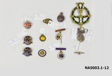 Whitehorse Historical Society Inc.
Medal - Badges, Approx 4. 1914 -1918 11. 1928-1929
1. Small circular white badge/red cross - bar pin 'A.N.C.M' 2. Oval medal with bar, long pin- red steward badge Royal Agricultural Show 3. Ditto - blue steward badge/brooch pin 4. AIF batch surmounted by crown 5. Oval Catholic religious medal/long chain 6. Oval badge: inscribed 7. Gold/Red/White/blue enamel badge - Free Trade 1929 8. Silver badge surmounted by crown/AP on red ground 9. Blue & gold badges: Eagle/shield/St John's Mitcham 10 & 11. Blue & gold badges: Eagle/shield/St John's Mitcham 11. Green & yellow circular on ring: Caufield Cricket Club 12. Ornate green/gold/white circular badge + pointed shaft1. Deo et Nomini Servimus A N C M 2. The Royal Agricultural Society of Victoria/Steward 3. The Royal Agricultural Society of Victoria/Steward 4. AIF - rest illegible/reverse: 4B349 5. Mostra TE ISS/Matrim/ Reverse: Congregation Des Enfants De Marie / scratched initials & date: B.Y.M 1891 6. P.J. Markham 678 Whitehorse Rd Mitcham Ringwood WNE 198 7.To promote land value, taxation and free trade. 4th International Conference Edinburgh 1929/Reverse: 50th anniversary of 'Progress & Poverty' by Henry George 8. Victoria ARP AH428 9&10. St John's Mitcham SJM Fide et Amorevinco/Reverse: scratched initials M.M. Millance 11. Caulfield Cricket Club1828-29 ccc/reverse: 20p.j. markham, mitcham post office -
 Eltham District Historical Society Inc
Film - Video (DVD), Frank Stokes, Stokes Family, 1950-1977
Various family scenes taken from outside the family home on the southeast corner of the intersection of Nyora Road and Pitt Street with Eucalyptus Road. Also, scenes of the Stokes Orchard and equipment used, construction of water reservoir at the end of Nyora Road near Reynolds Road and Diosma Road as well as early stages of the Stokes Orchard housing development. Frank Stokes worked as a qualified accountant at Kennons leather factory in Burnley, while living at 1 Thomas Street, Mitcham. He suffered from migraines and wanted to go back to the land (he had previously worked on farms and orchards since coming to Australia in 1926 both in WA and Vic.). He first travelled to the district by train in July 1942 to find land with the intention to establish an orchard. By chance he met Arthur Bird of Bird Orchard (bounded by Pitt Street, Eucalyptus Road and Wattle Grove) and they got talking over their common interest. Arthur put Frank up for the night and pointed out the land, 158 acres- Taylor Estate- £900, part of Crown Allotment 15, Section 5, Parish of Nillumbik (CA15) somewhat diagonally opposite Bird Orchard. He applied through the Riverina Agency to purchase the land who in turn had to get permission from Canberra to sell as there was a new government regulation banning land sales except for immediate production. He obtained a loan on his Mitcham house of £600 @ 5% and paid £450 deposit with quarterly payments of £15 over 5 years. The title to the property was issued May 15, 1946. He was helped and advised by Arthur Bird who farmed the neighbouring orchard. Early 1943 he took possession and would catch the train out to Eltham on Fridays after work and began building a hut for shelter and to lock up tools. He was able to pay a neighbour (Hawkins) to help with clearing and fencing 25 acres and with a horse and single furrowed plow, planted approximately 2,500 fruit trees - cherries, peaches, plums, almonds, pears, apricots and lemons as well as a few apples and oranges; a massive job. A huge problem was hares and rabbits eating all the new buds off the tiny trees. As well as laying poison he painted the trees with a mixture of cow manure and lime. Often working by moonlight. It was extremely difficult to get wire and wire netting because of the war but after much effort he obtained a permit from the Agricultural Department for supplies in March 1944. In February 1945 he applied for a permit to build a “packing shed” as no house building allowed. It was to be 33 feet x 21 feet and cost £312. Constructed mostly from second-hand materials, which was hard to obtain, especially iron for roofing. Frank finished work at Kennons October 31, 1945, and in March 1946 he sold the Mitcham house for £1230 plus £170 for furniture. The family of five then moved into a very unfinished at Eltham, which was a struggle to weatherproof. Eventually rooms were divided off and lined with hessian bags and whitewashed. Their income was firewood (cut and sold), selling rockery stones and cut sweet bursaria. (It was discovered during the 1940s that Bursaria contained the sunscreen compound Aesculin. The RAAF utilised this compound from Bursaria during WW2 for pilots and gunners.) The orchard’s first fruit sale was a 1/2 case of Le Vanq peaches in December 1947 - 8 shillings. In 1956 plans for house were drawn and Glen Iris bricks purchased (1956 Olympic Rings variant). The building of the house commenced in 1957 - 12 feet of original packing shed removed – and was completed in 1959. Water was connected from newly built pressure storage on the property at the end of 1959 and the electricity connection for the first time at 3pm on April 29, 1960. In the mid-1970s the Shire of Eltham divided the orchard up into numerous rate-able parcel lots, which became unaffordable for Frank. Consequently, Stokes Orchard was turned into a housing development by Macquarie Builders and marketed as the Stokes Orchard Estate in two stages; Stage 1 encompassing Scarlet Ash Court, Ironbark Close and Peppermint Grove bounded by Nyora and Eucalyptus roads c.1976 and Stage 2 encompassing Stokes Place, Orchard Way, The Crest and The Lookout bound by Nyora and Diosma roads c.1979. The development of Orchard Way, The Crest and The Lookout did not proceed as planned due to the lack of the sewer along Diosma Road and so many of the proposed lots were incorporated into five-acre parcels instead. With the arrival of the sewer along Diosma Road many years later, most of these five-acre parcels have since been subdivided many times.Representative of the orchard growing areas of ElthamMP4 00:24:39; 426MB Digital file only - Digitised by EDHS from a DVD copy on loan from Beryl Bradbury (nee Stokes), daughter of Frank Stokes. 24 min duration compilation of home movie Super 8mm film shot by Frank Stokes brother-in-law.beryl bradbury (nee stokes) collection, frank stokes, nyora road, stokes orchard, stokes orchard estate, stokes place, video recording -
 Kew Historical Society Inc
Photograph, James Venn Morgan's 100th Birthday, 1923
1823-1923.MR. JAMES VENN MORGAN. "FATHER OF" KEW."In a Village in Somersetshire in England on February 21, 1823, a son was born to George and Sarah Morgan. The child was so delicate that his parents feared that he would not live. How little ground the parents parents had for their fears may be judged from the fact that the boy, christened James Venn Morgan is still alive and hale. He is able to exhibit with pride the paper with its faded ink on which a clergyman wrote the certificate of his baptism almost 100 years ago. But for some slight infirmities of sight and hearing, Mr. Morgan, who is within six weeks of completing the 100th year of his life, is in good health, and is well able to attend to his business affairs. His immediate cause for regret is that he is not now able to do a day's work in his garden, as he was 12 months ago. After spending his early life in England, where he learned his trade as shoemaker, Mr Morgan came to Australia in April, 1851. He carried letters of introduction to Mr. Tripp, a solicitor, of Melbourne, who strongly recommended him to begin business as a shoemaker, and accordingly he opened a shop at the corner of Swanston and Bourke streets, where the Leviathan Stores now stand, and was not long in working up a good connection. Among his customers at that time Mr. Morgan recalls Mr. Justice A'Beckett and many leading men in law and medicine of the day. Then the news was flashed through Melbourne of the discovery of gold at Ballarat. Nothing can give a clearer idea of the excitement this news caused in Melbourne than that Mr. Morgan, who was a member of one of the first parties to leave for the diggings, left uncompleted in his workshop one of a pair of riding boots he was making for Mr. J. B. Weir. As the purchase of suitable clothing would have taken time, he set out to make his fortune wearing a top hat. At Ballarat he stayed for five or six weeks, and returned to Melbourne with 10oz. of gold. He remained in the city long enough to finish the second of the two riding boots, and then, with three companions, set out for Chewton, near Castlemaine. Here fortune smiled. The party tried their luck in an abandoned shaft, and in two weeks returned to Melbourne again after having won 35lb. weight of gold. How Kew Was Born. Mr Morgan was content with his success, and induced his partners to invest their money with him in land. After obtaining the advice of a friend, the party negotiated with Mr Samuel Watts, of Collngwood, who had recently purchased land from the Crown, and from him they took over at £15 an acre about 32 acres of land in the district that is now known as Kew. This land extended from where the Kew Post-office now stands to the locality of the Boroondara Cemetery. At that time there was not a house in the district, and there was a fairly large population of aborigines, but no white men. Here it was that Mr Morgan decided to settle, and, after having had the land surveyed, the partners apportioned it by drawing straws for the four sections into which it had been divided. One of them sold his holding later in the year for £100 an acre, and was sorry for it afterwards. In 1853 Mr. Morgan built the first house in Kew, and this house is the one in which he still resides. Here with his wife, he settled down to market gardening and dairying. He tells with a laugh how he was paid 1/ a lb for the first potatoes he grew, and 1/ a quart for milk. So successful was the new venture that he induced his father and other members of the family to come out to Australia to assist him. How different Kew of those days was from the Kew of to-day will be understood from Mr. Morgan's statement that for weeks at a time they never saw a a white face other than those of the family. The blacks, he says, although very noisy, were entirely friendly. Gradually the district became settled, Mr. Morgan parted with a portion of his holding, and subdivided and built on the remainder which he still retains. In 1884 he found himself in a position to retire from active business. Youth in Old Age. In Mr Morgan's garden, which is a large, one trees which he and his father planted more than 60 years ago are still bearing heavy crops of apples. Mr. Morgan has been a widower since 1915. He has three daughters all of whom are married, and numerous grandchildren and great-grandchildren. One of the great-grand children reccntly informed Mr. Morgan that he was about to be married. Perhaps the most striking characteristic of Mr. Morgan to-day is his activity. Not only does he move about with surprising alacrity, but is able to go into the streets and attend to his business affairs with but little fatigue The Argus, 17 January 1923, p.12.This work forms part of the collection assembled by the historian Dorothy Rogers, that was donated to the Kew Historical Society by her son John Rogers in 2015. The manuscripts, photographs, maps, and documents were sourced by her from both family and local collections or produced as references for her print publications. Many were directly used by Rogers in writing ‘Lovely Old Homes of Kew’ (1961) and 'A History of Kew' (1973), or the numerous articles on local history that she produced for suburban newspapers. Most of the photographs in the collection include detailed annotations in her hand. The Rogers Collection provides a comprehensive insight into the working habits of a historian in the 1960s and 1970s. Together it forms the largest privately-donated collection within the archives of the Kew Historical Society.A group portrait on the occasion of the 100th birthday of James Venn Morgan in 1923. Dorothy Rogers used this photograph in 'A History of Kew' (1973). It faces page 17. In the book, the caption reads "JAMES VENN MORGAN'S 100TH BIRTHDAY ANNIVERSARY. The party was held at 'Morganville'. Mr Morgan is shown with a group of descendants."James Morgans 100th Birthday Party. james venn morgan, kew, model dairy, dorothy rogers -
 Eltham District Historical Society Inc
Photograph - Digital Photograph, Marguerite Marshall, Strathewen Public Hall, 20 August 2008
Strathewen Public Hall, social and spiritual centre was later lost in the Black Saturday fires 2009. The Strathewen Community decided a community hall was needed in 1901. In 1902 locals built the hall with messmate trees. It was located on the Cottlesbridge-Strathewen Road. The first function was a Grand concert and Balll attended by about 120 people. Several denominations held Church services and Sunday School services in the Hall. It survived several bushfires until after this photo was taken when it was destroyed in Black Saturday, 9 February 2009. Published: Nillumbik Now and Then / Marguerite Marshall 2008; photographs Alan King with Marguerite Marshall.; p89 Strathewen was settled late, largely because it was difficult to access.1 Early selectors found it a struggle to survive. They had to do everything themselves, from felling trees for buildings, to taking produce to market along bush tracks that they had helped cut. Small dairy farms were typical but fruit became the district’s prime produce. The first settlers east of Arthurs Creek were brothers John and Duncan Smith whose station Glen-Ard was probably operated as a sheep run. Other early settlers were the Mann family, who were to donate land for the hall, provide postal services and John Mann was an Eltham Shire councillor from 1916 to 1919.2 In 1873 James Mann, his wife Jane and their six children, settled on 207 acres (83.7) (Lang Fauld Farm) on both sides of Eagles Nest Road, from the foot of Mount Sugarloaf to the bank of the Arthurs Creek. In 1883 James took up another selection on Chads Creek. It was very hard work and at times he was well behind with his rent. However the family had a good social life, attending the Primitive Methodist Church at the Arthurs Creek Township and on New Year’s Eve throwing a party for all the locals. By 1874 James Mann’s younger brother, John, selected 311 acres (125.8ha) between Eagles Nest Road and upper Arthurs Creek. He called it Carseburn after his home parish in Scotland. Tragically in 1875 John drowned in the Yarra River, at Richmond.3 John Mann’s oldest son, also John, later purchased Duncan Smith’s land, which he named Violet Glen. He was to give one acre (0.4ha) of this land for the Strathewen Hall site. A Mann family diary written at Carseburn in 1897, tells how the district’s name was selected. Strathewen is derived from ‘strath’ meaning ‘broad mountain valley’ and from the name of Ewen H. Cameron, the local parliamentarian for almost 40 years. ‘George Brain came around to get a petition signed to get a post office up here and we had to vote for a name—Strathewen, Glen-Ard, or Headcorie’.4 It was at Carseburn that a public meeting in 1901, decided to build the Strathewen Hall on the Cottlesbridge-Strathewen Road. In 1902 the locals built the hall with messmate trees. The first function was a Grand Concert and Ball attended by around 120 people and several Protestant denominations took turns to hold church services and Sunday School there. Fortunately the hall has survived bushfires to be the town’s spiritual and social centre.5 The area continued to develop and in 1909 a post office operated somewhere at Strathewen and from around 1916 at Carseburn.6 It was not until 1914 that land was bought to establish the Strathewen State School on School Ridge Road. The residents paid £100 to build it on two acres (0.8 ha) while the Education Department contributed £30 and leased the building annually for £1. When teacher Miss Mary Golding opened the school in 1917, it had no equipment.7 But in 1921 the Education Department provided desks and a hexagonal shelter shed (now a rare style in Victoria) and took control in 1925.8 By 1917 Strathewen was booming.9 George Apted had built a coolstore in 1916, and local orchardists bought storage space until the 1950s. This allowed the area to supply the market in and out of season. Guesthouses catered for growing tourism. In the mid 1920s Mrs Eleanor Sparkes built the guest-house Singing Waters, which operated through the 1930s. Her daughter Mrs Vera McKimmie, ran it until the 1950s and the house remains in Chads Creek Road. In the Great Depression land was cleared for timber to be sold as firewood and there was small scale sawmilling. However the orchard industry diminished for several reasons including the 1939 bushfires and rapid changes in production methods. Today the Apteds still operate an orchard and farm at Glen-Ard, which straddles the border between Strathewen and Arthurs Creek. It includes the southern part of Duncan Smith’s original Glen-Ard selection.This collection of almost 130 photos about places and people within the Shire of Nillumbik, an urban and rural municipality in Melbourne's north, contributes to an understanding of the history of the Shire. Published in 2008 immediately prior to the Black Saturday bushfires of February 7, 2009, it documents sites that were impacted, and in some cases destroyed by the fires. It includes photographs taken especially for the publication, creating a unique time capsule representing the Shire in the early 21st century. It remains the most recent comprehenesive publication devoted to the Shire's history connecting local residents to the past. nillumbik now and then (marshall-king) collection, strathewan public hall -
 The Beechworth Burke Museum
Photograph, c1900
Taken around 1858, depicting a row of five business buildings on a rocky, sloping hillside at New Town, with a view across to residences and open land. Businesses included, Joseph E. Bishop, Coach Builders; Straughair Duncan, Engineers, Blacksmiths & Farriers; Straughair Duncan, Beechworth Foundry; Wholesale & Retail Est. 1855, Mackenzie Family Store ; and T. Pratten, Grocer. The Mental Hospital can be seen in the background. Mark Straughair and John Duncan, established the Beechworth Foundry, Newtown in 1858 and went on to build an important industry, employing around sixteen men, after acquiring Alexander Roger's New Ford Street Foundry in the late 1860s. Making and repairing mostly mining and agricultural machinery for the Ovens District and a Beechworth brewery, the business continued to function after Straughair's death in 1882, up until the death of Duncan in 1896, when the business folded. This photograph is historically significant because it shows the development of the businesses in Beechworth from the early establishment of the town.Sepia rectangular photograph printed on photographic paper mounted on boardObverse: [Pin holes from circular tacks in all four corners] Reverse: 84.216-1/ Newtown/ 1997.2650/ 21/ BMM3056/new town, newtown, newtown beechworth, local business, 1858, 1850s beechworth, joseph e. bishop, coach builder, coach, mark straughair, m. straughair, straughair and duncan, john duncan, j. duncan, beechworth foundry, mackenzie family store, t. pratten, grocer, beechworth grocers, beechworth mental asylum, beechworth mental hospital, mayday hills mental asylum, mental hospital, alexander rogers, new ford street foundry, 1860s beechworth, 1860s, mining machinery, agricultural machinery, manufacturing, bridge road -
 Orbost & District Historical Society
black and white photographs, September 1914
Broadmeadows was home to the major army training camp for the Australian Imperial Force. The land was previously known as Mornington Park. It was a wide field, suitable for military practice, including training for the Light Horse regiments. It is the current location of the Maygar Army Barracks on Camp Road in Broadmeadows. To reach the camp, soldiers marched from Victoria Barracks in St Kilda Road and headed north up Sydney Road, only resting near Fawkner Cemetery. Soldiers slept in tents and food was basic. Training was hard, but it did not prepare soldiers for a modern war with machine guns, gas, shells and aeroplanes – technology that did not exist in previous wars. Some men only completed a few months training before departing on troopships from Port Melbourne. Once overseas, some soldiers received further training in Egypt. It is likely that these men are associated with the Orbost district.This photograph is a reminder of the personal stories of those who were involved in WW1.Two copies of a black / white photograph on dark grey buff cards. The photos show a group of soldiers having a meal. Some are sitting on the ground with others standing behind them.on back of 989.1 - "Sept 14 Broadmeadows"w.w.1 broadmeadows-army-training-camp -
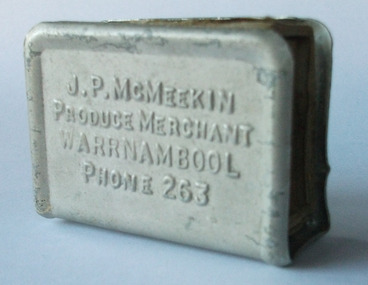 Warrnambool and District Historical Society Inc.
Document - Advertising item, Matchbox holder, Early 20th century
James Parker and William McMeekin arrived in 1881 in Victoria and commenced their business a large proportion of which was in Warrnambool. They opened up a butter, cheese and pork export trade with South Australia, which operated successfully for sometime before South Australia altered their tariff duties which badly affected trade. After a period dealing with Queensland, they set their sights further afield to London. The Warrnambool butter Factory was commenced around this time and William McMeekin was closely connected with its establishment. They traded in other farm produce and machinery as well as having interests in land, loans and insurance. William McMeekin was a member of the Town Council for some time and J.P. McMeekin was a member of the Villiers and Heytesbury Agricultural Society and was a director of the Warrnambool Cheese and Butter Factory. They operated their business from different sites in Kepler Street and Raglan Parade.An everyday item with a link to an individuals and a company which had a long association with Warrnambool.Aluminium cover with raised edge shaped to fit around top, bottom and one side. Designed to fit around match box leaving striking edge exposed. Embossed lettering on front and back. Contains matchbox with label depicting shell in green with green and yellow background. Box is faded blue. J.P. McMeekin Produce Merchant Warrnambool Phone 263 on front and back. Prov pat ** 367 on side. warrnambool, p.l. phillips, grocer, provision merchant, nestle warrnambool, nestle dennington, calendar 1919 -
 Warrnambool and District Historical Society Inc.
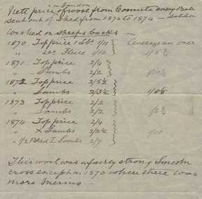
Document, Statement 1870-1874 Price of wool sold in London from “Coomete”, Circa 1870
Augustus Bostock was the 9th child of Robert & Rachael Bostock of Vaucluse Epping Forest, Van Diemen’s Land. He was only 4 years old when his mother died. He was inspired by his father to seek his fortune in the Western District of Victoria. He arrived around 1850. He married Margaret Aitkin in July 1865. Augustus owned several properties in the district and leased others. He sat on the court of Warrnambool, Mortlake or Hexham as required. He resided at Marramook in Hawkesdale and later moved to Vaucluse in Hopetoun Road Warrnambool, where he died in 1920 at the age of 87. He was involved in many aspects of life in the Western District, racing, cricket, and social activities to name a few. This statement shows the results of the wool sales for the early 1870’s being fairly strong Lincoln cross but earlier results were more merino This is one of a number of documents which relate to the Bostock family who were one of the most important pioneering families of the Western District. They owned and leased various properties around Warrnambool and were involved in many aspects of social and business life. The document itself is indicative of its time and provides an insight into the details and terms of such documents at the time.White lined note paper with black ink writing. Has table of prices for the years 1870-1874warrnambool, coomete, bostock, augustus bostock, 1870, -
 Warrnambool and District Historical Society Inc.
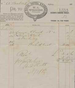
Document, Account weekly Royal Hotel Sydney 1876, 1876
One of a number of papers which relate to Augustus Bostock, this account shows charges for weekly lodgings and drinks. Augustus Bostock was the 9th child of Robert & Rachael Bostock of Vaucluse Epping Forest, Van Diemen’s Land. He was only 4 years old when his mother died. He was inspired by his father to seek his fortune in the Western District of Victoria. He arrived around 1850. He married Margaret Aitkin in July 1865. Augustus owned several properties in the district and leased others. He sat on the court of Warrnambool, Mortlake or Hexham as required. He resided at Marramook in Hawkesdale and later moved to Vaucluse in Hopetoun Road Warrnambool, where he died in 1920 at the age of 87. He was involved in many aspects of life in the Western District, racing, cricket, and social activities to name a few. This is one of a number of documents which relate to the Bostock family who were one of the most important pioneering families of the Western District. They owned and leased various properties around Warrnambool and were involved in many aspects of social and business life. Cream lined paper lined in blue and red. Logo centre top. Details handwritten in black ink.Royal Hotel Sydney W.J. Wilshire proprietor.warrnambool, augustus bostock, bostock, 1876, w j wilshire, -
 Warrnambool and District Historical Society Inc.
Letter, Mrs Bayles to Augustus Bostock re letting of Coomete, 1893
Augustus Bostock was the 9th child of Robert & Rachael Bostock of Vaucluse Epping Forest, Van Diemen’s Land. He was only 4 years old when his mother died. He was inspired by his father to seek his fortune in the Western District of Victoria. He arrived around 1850. He married Margaret Aitkin in July 1865. Augustus owned several properties in the district and leased others. He sat on the court of Warrnambool, Mortlake or Hexham as required. He resided at Marramook in Hawkesdale and later moved to Vaucluse in Hopetoun Road Warrnambool, where he died in 1920 at the age of 87. He was involved in many aspects of life in the Western District, racing, cricket, and social activities to name a few. This letter relates to lease details of Coomete from Mrs Bayles from whom he leased Coomete for many years. This is one of a number of documents which relate to the Bostock family who were one of the most important pioneering families of the Western District. They owned and leased various properties around Warrnambool and were involved in many aspects of social and business life. This letter shows the friendly terms which lessee and leasor enjoyed.Cream paper with black handwriting. Written on front and back.augustus bostock, warrnambool, coomete -
 Warrnambool and District Historical Society Inc.
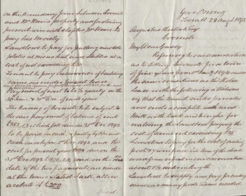
Letter, Hand written copy National Bank V A Bostock, Circa 1900
Augustus Bostock was the 9th child of Robert & Rachael Bostock of Vaucluse Epping Forest, Van Diemen’s Land. He was only 4 years old when his mother died. He was inspired by his father to seek his fortune in the Western District of Victoria. He arrived around 1850. He married Margaret Aitkin in July 1865. Augustus owned several properties in the district and leased others. He sat on the court of Warrnambool, Mortlake or Hexham as required. He resided at Marramook in Hawkesdale and later moved to Vaucluse in Hopetoun Road Warrnambool, where he died in 1920 at the age of 87. He was involved in many aspects of life in the Western District, racing, cricket, and social activities to name a few. This letter shows correspondence between the two firms of solicitors and is demanding payment of £500.00 as settlement by Bostock, to the National Bank. This is one of a number of documents which relate to the Bostock family who were one of the most important pioneering families of the Western District. They owned and leased various properties around Warrnambool and were involved in many aspects of social and business life. The document itself is indicative of its time and provides an insight into the details and terms of such documents at the time.Cream lined paper, with Solicitors letterhead printed in top left corner. Letter is hand written in black ink. Watermarked Cowan Extra strongKlingender, O’Mahony & Murray Solicitors at Warrnambool, Koroit, Port Fairy, Terang and Mortlake. Telephone No. 51. The letter has come from Malleson, England & Stewart of Melbourne. Watermarked Cowan Extra Strongwarrnambool, bostock, national bank, klingender, o’mahony, murray, malleson england and stewart,1900, -
 Warrnambool and District Historical Society Inc.
Letter, Augustus Bostock to E Plumridge, 1905
Augustus Bostock was the 9th child of Robert & Rachael Bostock of Vaucluse Epping Forest, Van Diemen’s Land. He was only 4 years old when his mother died. He was inspired by his father to seek his fortune in the Western District of Victoria. He arrived around 1850. He married Margaret Aitkin in July 1865. Augustus owned several properties in the district and leased others. He sat on the court of Warrnambool, Mortlake or Hexham as required. He resided at Marramook in Hawkesdale and later moved to Vaucluse in Hopetoun Road Warrnambool, where he died in 1920 at the age of 87. This letter relates to crossing sheep and answers three questions posed by Mr. E Plumridge in relation to the breeding of comeback sheep. E Plumridge is mentioned on Trove as holding classes in wool classing at Gordon technical College at Geelong. This is one of a number of documents which relate to the Bostock family who were one of the most important pioneering families of the Western District. They owned and leased various properties around Warrnambool and were involved in many aspects of social and business life. This letter reflects the knowledge and experience of Augustus Bostock in the breeding of sheep and also his willingness to share this knowledge. It therefore has social and historical significance.Cream lined paper with wide margin on left hand side. One page written in black ink.Addressed from Marramook 16th Jan 1905 to Mr. E Plumridge of Marshalltown. Signed Augustus Bostock.augustus bostock, plumridge geelong, marramook, warrnambool -
 Warrnambool and District Historical Society Inc.
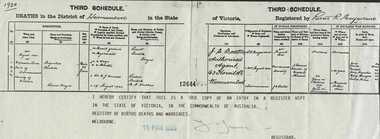
Certificate, Death of Augustus Bostock, 1989
Augustus Bostock was the 9th child of Robert & Rachael Bostock of Vaucluse Epping Forest, Van Diemen’s Land. He was only 4 years old when his mother died. He was inspired by his father to seek his fortune in the Western District of Victoria. He arrived around 1850. He married Margaret Aitkin in July 1865. Augustus owned several properties in the district and leased others. He sat on the court of Warrnambool, Mortlake or Hexham as required. He resided at Marramook in Hawkesdale and later moved to Vaucluse in Hopetoun Road Warrnambool, where he died in 1920 at the age of 87. He was involved in many aspects of life in the Western District, racing, cricket, and social activities to name a few. Augustus was the son of Robert and Rachel Bostock. He spent the first 17 years of his life in Tasmania before living in Victoria for 70 years.This is one of a number of documents which relate to the Bostock family who were one of the most important pioneering families of the Western District. They owned and leased various properties around Warrnambool and were involved in many aspects of social and business life. This death certificate of Augustus provides family history informationRectangular white paper overprinted with light green pattern stating State of Victoria. Blue stamp dated 16 Mar 1989. Dated 1920 in top left corner. Typed form filled in, in black handwriting.Registered by Robert R Macfarlane, date stamped 16 Mar 1989. Extract no 12644augustus bostock, margaret aitkin, warrnambool -
 Warrnambool and District Historical Society Inc.
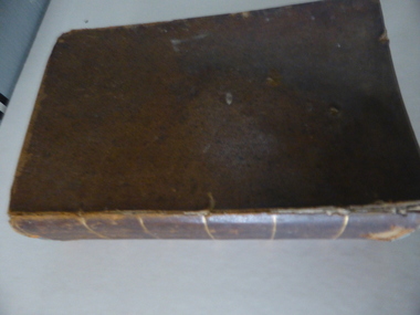
Book, A Complete Epitome of Practical Navigation - J W Norie, 1848
This book is a 19th Century treatise on aids to navigation. It belonged to John Cowtan who held land near the Cassady's Bridge area in Caramut Road today (he was related to the Cassady family) and who is mainly important in the history of Port Fairy. Captain John Cowtan was a ship's master for John Griffiths and a Launceston entrepreneur and ship owner between 1839 and 1844. In 1847 he went into partnership with John Bland, establishing a merchant's business with riverside buildings at the Port Fairy wharf. He left Port Fairy in the 1860s. The date of John Cowtan's signature in this book is 1849 (certainly a very early one in our history) and inside the front cover he has written notes about the local weather, mainly as it affected sailing conditions in late 1849 and early 1850. These notes are of great historical interestThis book is of great interest because it belonged to a Port Fairy historical figure and because of the hand written weather notes inside the front cover. This is a hard covered,leather bound book of 680 pages. It contains printed text, illustrations, tables, maps and sketches.One page is torn Some pages are stained. . J Cowtan 1849john cowtan, port fairy -
 Kiewa Valley Historical Society
Newspaper article- Double page article. Pages 30 & 83 from the Herald Sun Newspaper. February 18, 2006 regarding preserving Victoria’s High Country Huts
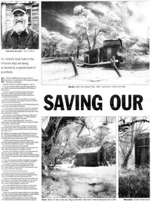
The arrival of explorers Hume & Hovell in 1842 brought about the widespread clearing of land in the valleys for pastoral uses and the displacement the original inhabitants in the high country which became a boon for cattlemen due to extensive lush summer grazing for cattle. High country cattlemen built a variety of huts for shelter and storage, when driving cattle up to the plains in summer, during mustering and bringing the cattle down from the mountains before winter closed in. These same huts now provide shelter from the elements for hikers, bush walkers and skiers. Wallace’s Hut is the oldest of the Cattleman’s huts still standing in the Alpine National Park and is classified under the National Trust. Due to their age and the ravages of the elements, including bush fires, many of the huts have been destroyed, or are falling into disrepair. Groups of willing volunteers are now working to preserve as many of the huts as possible with restoration or rebuilding.The numerous cattleman’s huts of the Alpine National Park and the colourful characters who erected them represent a significant part of the history of the high country area and early cattle grazing, which has been the theme for many poets and film-makers alike. They also have a significant role in the early days of the SECV when they were used by surveyors and other workers for shelter and temporary accommodation. More recently the huts have functioned as shelter for hikers and skiers caught out in the elements and a refuge along the long trek for bush walkers. They are a popular attraction for tourists and feature prominently in much of the tourist information of the region. Black and white double page Newspaper article from the Herald Sun Newspaper of February 18, 2006 regarding the efforts of Mr David Oldfield to preserve Victoria’s remaining High Country Huts through his photography and efforts to restore old and Re-build missing ones. Article shows a photograph of David Oldfield and some of his photographic work of the huts. Page number and date printed at top of each page 30 Herald Sun, Saturday, February 18, 2006 Herald Sun, Saturday, February 18, 2006 83 cattlemen's huts; david oldfield; bogong high plains; wallace's hut; high country; alpine national park -
 Kiewa Valley Historical Society
Photographs –Collection of 10 copies and original black and white photographs and printed articles relating to skiing on the Bogong High Plains
After World War II, the Kiewa Hydro-Electric Scheme was started in the Kiewa River Valley by the State Electricity Commission of Victoria. On land previously used only for summer cattle grazing in the natural alpine grasslands, the first ski lodge was built in 1948 by workers from the hydro scheme as skiing was a popular recreation. Many of the hydro employees were of European background and had grown up enjoying skiing and snow sports in their homelands and were keen to continue to pursue their winter sports interests. The first lift, a rope tow, was built in 1951 at Falls Creek and the first chairlift in Australia was constructed there in 1957. Two T-Bars were opened in 1961. In 1964, the Victorian Municipal Directory recorded that Falls Creek had 29 ski club lodges and 16 commercial lodges. The area became a popular tourist destination for both winter and summer sports.: Employees of the State Electricity Commission of Victoria in the Kiewa River Valley were the earliest skiers on the Bogong High Plains and built one of the first ski lodges at Falls Creek. They were amongst those pivotal in the development of the skiing and tourist industry at Falls Creek and on the Bogong High Plains. Collection of 10 copies and original black and white photographs and printed articles relating to skiing on the Bogong High Plains. Some pieces have been enlarged to A3 poster size copies for display purposes 1. Copy of black and white photograph of group of skiers at Falls Creek 2. Copy of photograph of early skier on Bogong High Plains with temporary buildings and tents in the background 3. Copy of photograph of 3 skiers on Mt McKay 4. Copy of SECV photograph of Rocky Valley Camp under snow 5. Early sepia photograph of Falls Creek village with skiers in the foreground 6. Copy of a page from booklet (SECV?) promoting the benefits of owning a holiday home in the Bogong Village area 7. Copy of a page from booklet (SECV?) promoting the benefits of holidaying in and around Falls Creek/Mt Beauty 8. Panoramic view of ski fields with skis in the foreground 9. Photograph of young skier (identity unknown) 10. Photograph of 2 male skiers (identity unknown) performing a small jump 1. Bogong Ski Club Members & Friends 1944 2. Jack Neve – electrician. Rocky Valley 3. 17.5.55 Skiers ascending Mt McKay 4. State Electricity Commission of Victoria. Date:17.8.55 No:K8132 Kiewa Hydro Electric Works. Rocky Valley Camp – From Engineering Office 5 & 9 No markings 6 & 7 Short article relating to photos on each page 8. Handwritten signature on rear of photo (Sandra Conea) 10 Faded unreadable photographers stamp and handwritten numbers 6875 on rear secv; bogong high plains; skiers; falls creek; tourism -
 Kiewa Valley Historical Society
Photographs – Bogong High Plains - Set of 16 black and white photographs mounted back and front on 3 pieces of heavy black card likely removed from a photograph album
After World War II, the Kiewa Hydro-Electric Scheme was started in the Kiewa River Valley by the State Electricity Commission of Victoria. On land previously used only for summer cattle grazing in the natural alpine grasslands, the first ski lodge was built in 1948 by workers from the hydro scheme as skiing was a popular recreation. Many of the hydro employees were of European background and had grown up enjoying skiing and snow sports in their homelands and were keen to continue to pursue their winter sports interests. The first lift, a rope tow, was built at Falls Creek in 1951 and the first chairlift in Australia was constructed there in 1957. Two T-Bars were opened in 1961. In 1964, the Victorian Municipal Directory recorded that Falls Creek had 29 ski club lodges and 16 commercial lodges. The area became a popular tourist destination for both winter and summer sports.Employees of the State Electricity Commission of Victoria in the Kiewa River Valley were the earliest skiers on the Bogong High Plains and built one of the first ski lodges at Falls Creek. They were amongst those pivotal in the development of the skiing and tourist industry at Falls Creek and on the Bogong High Plains. Black and white photographs of varying sizes mounted decoratively on heavy black Card. Some pages display a brief description printed in white ink 1. 4 photographs- displayed diagonally across page. 2 pictures of a group of men standing in the snow in front of a car with a loaded trailer behind. 1 photo of skiers. 1 photo of show hanging in tree branches. 2. 2 photographs- showing Upper Kiewa Road with snow in the background 3. 3 photographs- of skiers and 1 photo of 2 of men posing in the snow & 1 photo of 2 men posing shirtless in warmer weather. 4. 2 photographs- arranged diagonally on page showing early buildings and construction at Bogong Village 5. 2 photographs- 1 showing view of Bogong Village from higher up the mountain. 1 showing early Bogong High Plains road 6. 1 photograph- showing view down along Kiewa Valley from higher up in the mountains 1. Handwritten in white ink – A TRIP TO THE PLAINS 2. Handwritten in white ink – UPPER KIEWA ROAD MT FAINTER IN BACKGROUND 3 – 6. No markings bogong village; upper kiewa road; bogong high plains; falls creek; skiers -
 Warrnambool and District Historical Society Inc.
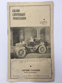
Booklet, Grand Centenary process, 1947
This is a program of the Centenary Procession that took place in Warrnambool in 1947 to celebrate the 100th anniversary of the city’s founding in 1847. It was originally intended to celebrate the 100th anniversary in 1940 but these celebrations were postponed because of World War Two. In 1947 centenary celebrations were held but on a less lavish style. 1947 was a more appropriate year as 1847 was the year of the first land sales for Warrnambool and the arrival of the first European settlers in the town. The 1947 celebrations included a Grand Procession which was estimated to have been watched by 20,000 people. A similar number saw the bonfire and fireworks display in Albert Park the same evening. The celebrations lasted a week and included a choral thanksgiving festival in the Botanic Gardens, a massed band display and a ‘Warrnambool Can Make It’ exhibition of local manufactures. The well-known historian and Town Clerk at the time, Henri Worland took a prominent role in the organizing of the celebrations. This little booklet is of considerable importance because it contains a short description of the floats and the names of those connected with the various floats of the Warrnambool Centenary Procession of 1947. It not only gives us a better idea of what and who were in the procession but it now enables us to better label the many photographs we have of this procession and to identify the people in the photographs. The program is a valuable source of information for historians. It also is a good example of the type of celebratory procession that was popular 70 years ago. This is a paper program of the Warrnambool 1947 Centenary procession. It has four pages and a buff-coloured cover. The front cover has a sepia-toned photograph of the first car purchased in Warrnambool (1906) and on the back cover there is an advertisement for Lane’s Bus Services. The inside front cover has an advertisement for Guyett and Sons Furniture Store and there are other advertisements throughout the pages. The printed text on buff-coloured paper gives details of the 29 floats in the ‘Mechanized’ Section and of the 27 floats in the ‘Back to the Horse Pageant’ Section. The pages were stapled but the staples have been removed. There has been some silverfish damage. Front Cover: ‘Grand Centenary Procession, Thursday, March 27, 1947, Souvenir Catalogue, Price Sixpence, Joint Organisers, C.A.Rogers, P.T.Parker, F.E.Utting’. warrnambool centenary, 1947 henri worland -
Glen Eira Historical Society
Document - Bakewell Family
There are 3 items about this family of early European settlers in Victoria: 1/A photocopy of an extract “Early Pioneer Families of Victoria and Riverina” – Henderson Page 441-442 The Bakewell Family of Burnewang and Tooradin”. It includes a photo of John Bakewell (1807-1888). It contains two pages and describes Bakewell’s property expansion. 2/An original copy of handwritten, unsigned undated research notes on John Bakewell property holdings taken from St Kilda Rate Book (1859-1873). It describes the land allotment. 3/A typed, unsigned, undated extract from 'The Howitts in Australia by Mary Howitt' - Mary Howitt, Vic Hist Mag 1913 Vol 3 No. 1. Reference – Memoirs of a Stockman, Harry Peck, 1853 Map, Foot Plot CCXLVI at Kooyong & Glen Eira Road. It provides a brief outline of the lives of brothers Robert and John Bakewell.the bakewell family, early pioneer families, henderson, bakewell john, port phillip, burnewang, bakewell robert, howitt godfrey dr, lord goderich, tooradin, phoebe, friends' school ackworth, yorkshire, nottingham, shaw john wyberg, plenty river, businesses, goldsbrough richard, goldsbrough mort and company ltd., glaziers, squatters, burnewang, mantons, tooradin, red bluff, torbinurruck, great swamp, brenanah, westernport, numerella, snowy river, orbost, green hills b, caramut, lyall william, mickle john, buckland john, notts, england, balderton, weddings, jane emily, howitt emanuel, farnsfield, lever mary, howitt thomas, heanor, derbyshire, howitt godfrey, scales john, exeter college oxford, downing college cambridge, guerard von, wayne john, south warnborough manor, harrison robert, lord john, jamaica, mary alice, dr. miller, miller john francis compton, emmie joan, mary emily, clifton hotel welbeck street, phoebe alice, anne edith, british museum, land values, settlements, st. kilda, elsternwick, inkerman street, st. kilda east, kew, memoirs of a stockman, harry peck -
Glen Eira Historical Society
Article - Shoobra Road, 2, Elsternwick
Three real estate advertisements and one article about the sale of 2 Shoobra Road on three occasions: 1/Article from Bayside Weekly of July 2009 by Neil Clerehan describing the house’s history and features. Includes one exterior and two interior colour photographs. 2/Advertisement for sale of 2 Shoobra Road in Bayside Weekly of July 2009. It describes house’s features, one exterior colour photograph. 3/Advertisement for sale of 2 Shoobra Road by Auction dated 10/08/2011 in Melbourne Weekly Bayside. Describes house features and includes one colour exterior photograph and plan of the land. 4/Advertisement for sale of 2 Shoobra Road by auction in Melbourne Weekly Bayside dated 06/06/2012. Describes house features and includes one exterior and one interior colour photograph.shoobra road, elsternwick, city of glen eira, city of caulfield, city of moorabbin, elsternwick, glen huntly road, glen huntly railway station, elsternwick railway station, caulfield north, tbm, persichetti leonard, meltzer selwyn, architectural styles, edwardian style, architectural features, gables, verandahs, lead lights, brick houses, biggin scott, crowe amy, stavrakis bill, williams kharla, ceilings, real estate agents -
 Eltham District Historical Society Inc
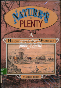
Book, Michael Jones, Nature's plenty : a history of the City of Whittlesea, 1992
This book explores Whittlesea's history from early 1830's to 1991. Environment of the Aboriginal people about the the time of European settlement. Possible use of a 'swamp management system' now buried under Yan Yean reservoir. Smallpox epidemics among Aboriginal people prior to settlement - probably from the activity of nearby European sealers. Estimations of Aboriginal populations. Scattered references throughout. Subjects Health - Infectious diseases - Smallpox. Settlement and contacts - Colonisation - 1788-1850. Settlement and contacts - Colonisation - 1851- Environment - Land management. Demography. Woiwurrung / Wurundjeri / Woiwurung people (S36) (Vic SJ55-05) Yan Yean (Vic SJ55-05) Eden Park (Vic SJ55-05) Whittlesea (Vic SJ55-05) Diamond Creek (Vic SJ55-05) Kingslake (Vic SJ55-05) Whittlesea (Vic.) -- History.xvi, 319 p., [16] p. of plates : ill. (some col.), maps (some col.), ports. ; 28 cm. the plenty, farming, settlement, gold rush, plenty river, donnybrook, germantown, separation, thomastown, whittlesea, epping, woodstock, city of whittlesea, railway, yan yean, roll of honour -
 Eltham District Historical Society Inc
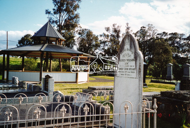
Photograph, A walk through the cemetery at Kangaroo Ground, Diana Bassett-Smith, 1 October 2001, 2001
The Kangaroo Ground Cemetery celebrated its 150th anniversary in 2001. Celebrations included the opening of a new rotunda on the 26 October 2001. Ths photo is a part of a brief collection of reminiscences by Diana Bassett-Smith of locals who are buried at Kangaroo Ground Cemetery along with 17 photographs following a visit on 1 October 2001. "One other headstone, that of James Wilson. It was a Wilson who had a nursery at the North Eastern end of Bourchiers Road on the land known as Tintagell alongside the Yarra. He grew trees, pines in particular, and supplied within the district and to the gardens of Melbourne. According to Jimmy Cook. The last of the warriors is between the gate and the river. And confirmed by Dorrie Bourchier that the original pines to what is now our property came from Wilson. The only one left now is by Passiona. Lightening claimed the one at the corner of our drive." Colour photograph printkangaroo ground cemetery, rotunda, james wilson