Showing 81066 items
matching lap-of-the-lake
-
 Greensborough Historical Society
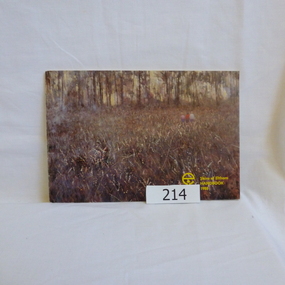
Book, Shire of Eltham, Shire of Eltham Handbook 1988, 1988_
... Shire of Eltham Handbook 1988...Shire of Eltham ...The Shire of Eltham was a Local Government Area located about 25 kilometres northeast of Melbourne. The shire covered an area of 277.13 square kilometres and existed from 1856 until 1994.Guide to services provided by Shire of Eltham52 pages, illus. Front cover is a copy of the painting "Panton Hill" by David Armfield.eltham, shire of eltham, handbooks -
 Greensborough Historical Society
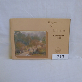
Book, Shire of Eltham, Shire of Eltham Handbook 1991, 1991_
... Shire of Eltham Handbook 1991...Shire of Eltham ...The Shire of Eltham was a Local Government Area located about 25 kilometres northeast of Melbourne. The shire covered an area of 277.13 square kilometres and existed from 1856 until 1994.Annual guide to services in Shire of Eltham60 pages, Illus. Printed on beige paper. Front cover has a copy of the painting "Brougham Street Bridge" by Hilary Jackman.eltham, shire of eltham, handbooks -
 Greensborough Historical Society
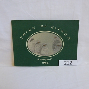
Book, Shire of Eltham, Shire of Eltham Handbook 1992, 1992_
... Shire of Eltham Handbook 1992...Shire of Eltham ...The Shire of Eltham was a Local Government Area located about 25 kilometres northeast of Melbourne. The shire covered an area of 277.13 square kilometres and existed from 1856 until 1994.Annual guide to services in Shire of Eltham72 pages, illus. Front cover has a copy of a sketch "Frogmouths" by Margo Kroyer Pederson on dark green cover. Printed on recycled paper.eltham, shire of eltham, handbooks -
 Greensborough Historical Society
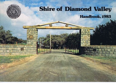
Book, Shire of Diamond Valley Handbook 1983, 1983_
... Shire of Diamond Valley Handbook 1983...Shire of Diamond Valley ...Guide to services provided by Shire of Diamond Valley. The Shire of Diamond Valley was a Local Government Area located about 20 kilometres northeast of Melbourne. The shire covered an area of 74.38 square kilometres and existed from 1964 until 1994.Annual guide to services in Shire of Diamond Valley32 pages, col illus., maps. Cover illustration of the bluestone gateway, main entrance to Yarrambat Park, opened 1982.shire of diamond valley, greensborough, handbooks -
 Greensborough Historical Society
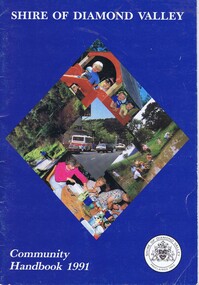
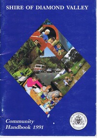
Book, Shire of Diamond Valley Community Handbook 1991, 1991_
... Shire of Diamond Valley Community Handbook 1991...Shire of Diamond Valley ...Guide to services provided by Shire of Diamond Valley. The Shire of Diamond Valley was a Local Government Area located about 20 kilometres northeast of Melbourne. The shire covered an area of 74.38 square kilometres and existed from 1964 until 1994.Annual guide to services in Shire of Diamond Valley36 pages, col illus., maps. Front cover is a collage of scenes from Diamond Valley, back cover illustration of a copy of "Summer Panorama, Tabletop, NSW" by Max Dimmack, from the Shire of Diamond Valley Art Collection.shire of diamond valley, greensborough, handbooks -
 Greensborough Historical Society
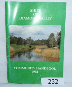
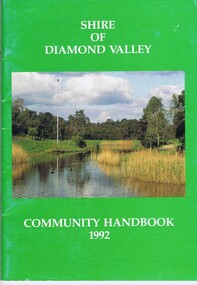
Book, Shire of Diamond Valley Community Handbook 1992, 1992_
... Shire of Diamond Valley Community Handbook 1992 ...Shire of Diamond Valley ...Guide to services provided by Shire of Diamond Valley. The Shire of Diamond Valley was a Local Government Area located about 20 kilometres northeast of Melbourne. The shire covered an area of 74.38 square kilometres and existed from 1964 until 1994.Annual guide to services in Shire of Diamond Valley52 pages, col illus., maps. Cover illustration of Kalparrin Gardens Greensboroughshire of diamond valley, greensborough, handbooks -
 Greensborough Historical Society
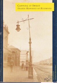
Book, Carringbush Regional Library, Copping it sweet: shared memories of Richmond, 1988_
... Copping it sweet: shared memories of Richmond...City of Richmond ...History of Richmond from 1850 to 1980s, including many residents' recollections.Paperback. 253 p., black and white and colour illustrationsrichmond -
 Greensborough Historical Society
Map, Keelbundora. Counties of Bourke and Evelyn, 1950_11
... Keelbundora. Counties of Bourke and Evelyn...Victoria. Department of Lands and Survey ...Covers area bounded by Merri Creek, Yarra River, Plenty River and Crown Portions 24 to 28, with section including Maroondah Aqueduct and Darebin Creek.Photocopy of digitised mapkeelbundora (parish) -
 Greensborough Historical Society
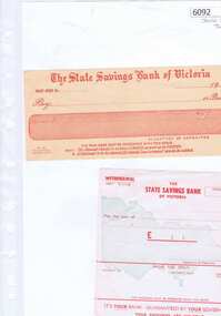
Form, State Savings Bank of Victoria, State Savings Bank of Australia: Withdrawal forms, 1957_10
... State Savings Bank of Australia: Withdrawal forms...State Savings Bank of Victoria ...Pre-decimal bank withdrawal forms from the State Savings Bank of Victoria. The State Bank of Victoria was an Australian bank that existed from 1842 until 1990 when it was taken over by the Commonwealth Bank. It was owned by the State of Victoria. Two bank withdrawal forms printed in red on white paperstate savings bank of victoria -
 Greensborough Historical Society
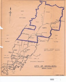
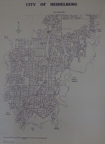
Map, City of Heidelberg, City of Heidelberg, 1962, 02/02/1962
... City of Heidelberg, 1962...City of Heidelberg ...Map of City of Heidelberg showing boundaries of its six wards; North Ward is highlighted, covering Watsonia, Greensborough, part Bundoora, St Helena, Plenty, Yarrambat and Diamond Creek.Blue print mapCity of Heidelberg Scale: 1" to 1 ml. G.M.H. 2.2.62city of heidelberg, heidelberg - maps -
 Greensborough Historical Society
Map, Melbourne and Metropolitan Board of Works. Survey Division, MMBW, Yarra 2500 / 11.21. Bundoora, east of Plenty Road, 1979_01
... MMBW, Yarra 2500 / 11.21. Bundoora, east of Plenty Road....Melbourne and Metropolitan Board of Works. Survey Division. ...Melbourne and Metropolitan Board of Works. Yarra 2500 [base map] 11-21. Bundoora, east of Plenty Road. Parish of Keelbundoora 2856, Municipalities of Diamond Valley 257, Preston 225 and Whittlesea 239. Prominent streets include: Grimshaw Street, Settlement Road and Plenty Road. Includes Yulong Park.MMBW Map in 1:2500 [scale] series. Cream parchment with green tape reinforcing on edges and punched holes on left edge.mmbw, melbourne and metropolitan board of works, shire of diamond valley, bundoora - maps -
 Greensborough Historical Society
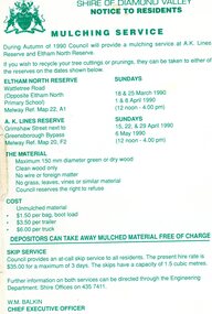
Leaflet, Notice to residents: mulching service, Shire of Diamond Valley, 1990
... Notice to residents: mulching service, Shire of Diamond...Shire of Diamond Valley ...Notice informing residents of a mulching service located at A. K. Lines Reserve and Eltham North Reserve on selected Sunday during March, April and May 19901 p. printed in green on off-white paper shire of diamond valley, mulching -
 Greensborough Historical Society
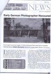
Newsletter, Friends of Westgarthtown Inc, Friends of Westgarthtown Inc. News. Vol. 14, No. 3, November 2010, 02/11/2010
... Friends of Westgarthtown Inc. News. Vol. 14, No. 3...Friends of Westgarthtown Inc. ...Information on Westgarthtown history and personalities, including photographer Fred Kruger, the Ziebel family, and the origins of the Pura Milk brand.8 p. newsletter, with leaflet westgarthtown, thomastown -
 Greensborough Historical Society
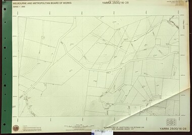
Map, Melbourne and Metropolitan Board of Works. Survey Division, MMBW, Yarra 2500 / 16.28. East of Hurstbridge, 1977_10
... MMBW, Yarra 2500 / 16.28. East of Hurstbridge....Melbourne and Metropolitan Board of Works. Survey Division. ...Melbourne and Metropolitan Board of Works. Yarra 2500 [base map] 16.28. East of Hurstbridge. Municipalities of Whittlesea 239, Eltham 238 and Diamond Valley 257. Prominent streets include: Boyds Road, Bannons Lane and Wattle Tree Road. MMBW Map in 1:2500 [scale] series. Cream parchment with green tape reinforcing on edges and punched holes on left edge.mmbw, melbourne and metropolitan board of works, shire of diamond valley -
 Greensborough Historical Society
Maps, City of Heidelberg 1989, 1989_05
... City of Heidelberg 1989...City of Heidelberg ...Map of City of Heidelberg as at 18/11/1994Blueprint, Scale 1km: 8 cmcity of heidelberg, heidelberg -
 Greensborough Historical Society
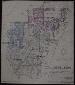
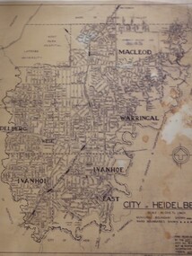
Maps, City of Heidelberg 1974, 1974c
... City of Heidelberg 1974...City of Heidelberg ...City of Heidelberg showing Municipal and Ward boundaries, prepared by City Engineers Department. Made for Council use; copies available for sale to the public.Blueprint, 2 copies, one with some roads hand coloured, showing municipal and ward boundaries. Scale: 20 chains to 1 inchG. M. Hutchins. Authorised charge 50c.city of heidelberg, heidelberg -
 Greensborough Historical Society
Article - Website, National Trust of Australia (Victoria), Mont Park: Statement written by National Trust of Australia (Victoria), 17/09/2010
... Mont Park: Statement written by National Trust of Australia...National Trust of Australia (Victoria) ...Statement of Cultural heritage Significance for Mont Park acquired by Victorian state government in 1909 and used as a mental hospital complex comprising Larundel Kingsbury and Greswell facilities, finally decommissioned in1969. Contains extensive descriptions of regionally significant indigenous and exotic vegetation, landscaped by designer Hugh Linaker.2p. typescriptmont park, larundel, gresswell, hugh linaker -
 Greensborough Historical Society
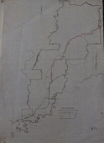
Maps, Shire of Heidelberg, 1920s
... Shire of Heidelberg...Shire of Heidelberg ...Map of main roads within Shire of Heidelberg, probably those for which the Shire was responsible for maintainingMap of main roads within Shire of Heidelberg, hand coloured, and Hurstbridge rail line. 40 chains: 1 inch971shire of heidelberg, heidelberg -
 Greensborough Historical Society
Map, Municipality of Heidelberg Plan No. 480, 17/10/1948
... Municipality of Heidelberg Plan No. 480...Melbourne & Metropolitan Board of Works ...Map shows streets, buildings, river and major drainage easements in area covered by West boundary Sellars Street, North boundary Yando Street & South boundary Grimshaw Street. Adjoins Map No. 481 to East. Black & white map, features marked in green, gradients in red. Scale: 160 feet to 1 inchgreensborough -
 Greensborough Historical Society
Map, Municipality of Heidelberg Plan No. 481, 23/9/1949
... Municipality of Heidelberg Plan No. 481...Melbourne & Metropolitan Board of Works ...Central area of Greensborough, South boundary Grimshaw Street, showing river and buildings in green and gradients in red. Adjoins Map No. 480 to West.Black & white map with features in red and green. Scale: 160 feet to 1 inch.greensborough, grimshaw street greensborough -
 Greensborough Historical Society
Map, City of Heidelberg: Municipal and Ward boundaries, 1967c
... City of Heidelberg: Municipal and Ward boundaries...City of Heidelberg ...This map of the City of Heidelberg was issued subsequent to the separation of Heidelberg's North Ward to become the Shire of Diamond ValleyBlack on waxed paper. Scale: 20 chs to 1 inchG M Hutchins. 50c.city of heidelberg, heidelberg -
 Greensborough Historical Society
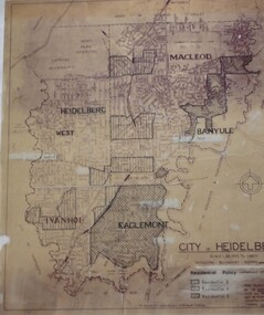
Map, City of Heidelberg: Residential Policy, 1976c
... City of Heidelberg: Residential Policy...City of Heidelberg ...Shows residential zones 3, 4 & 5 established by Residential Policy adopted 13/12/1976Black print on waxed paper. Scale: 20 chs to 1 inchG M Hutchins. $1city of heidelberg, heidelberg -
 Greensborough Historical Society
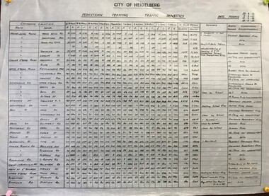
Diagram, Pedestrian crossing traffic densities, by City of Heidelberg, 1958_
... Pedestrian crossing traffic densities, by City of...City of Heidelberg ...Readings were taken at 34 pedestrian crossings in the Heidelberg and Greensborough areas, of pedestrians and vehicles at hourly intervals between 8 am and 6 pm on four Fridays in August and September 1958Table of pedestrian counts.traffic, heidelberg, greensborough -
 Greensborough Historical Society
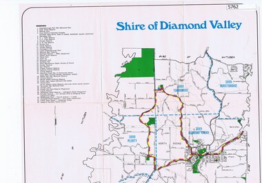
Map, Map - Shire of Diamond Valley, 1990c
... Map - Shire of Diamond Valley...Shire of Diamond Valley ...Map issued by the Shire of Diamond Valley showing location of key organisations and features Map printed in colour, one sideshire of diamond valley -
 Greensborough Historical Society
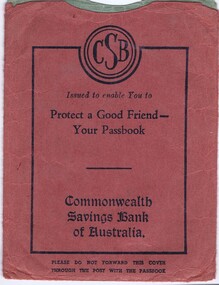
Passbook cover, Commonwealth Savings Bank of Australia, 1950s
... Commonwealth Savings Bank of Australia...Commonwealth Savings Bank of Australia ...Passbook covers were "Issued to enable you to protect a good friend - your passbook"Two passbook covers, one ochre, black print, one light green, blue printbank passbook cover, commonwealth bank of australia -
 Greensborough Historical Society
Book, A Teaching Resource / issued by State College of Victoria - Bendigo, 1974_
... A Teaching Resource / issued by State College of Victoria...State College of Victoria - Bendigo ...A collection of articles for those studying Primary Education. Includes philosophy of teaching and learning and curriculum outlines.An historical record of teaching in the 1970s.Soft cover book with light orange cover; 239 pages.Owner's name on front cover.primary education, primary curriculum -
 Greensborough Historical Society
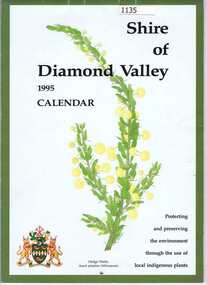
Calendar, Shire of Diamond Valley, Shire of Diamond Valley 1995 Calendar, 1995_
... Shire of Diamond Valley 1995 Calendar....Shire of Diamond Valley ...Copies of this calendar were distributed to households in the Shire of Diamond Valley. This 1994 Calendar features images of indigenous plants painted by Jan Lowe. Includes a Guide to services provided by Shire of Diamond Valley. The Shire of Diamond Valley was a Local Government Area located about 20 kilometres northeast of Melbourne. The shire covered an area of 74.38 square kilometres and existed from 1964 until 1994.The annual calendar is a record of the activities and services in the former Shire of Diamond Valley.28 page calendar illustrated with images of local flora, with 16 page liftout "Shire of Diamond Valley Resource Guide"shire of diamond valley, shire of diamond valley calendar, jan lowe -
 Greensborough Historical Society
Book, Shire of Diamond Valley, Shire of Diamond Valley Community Handbook 1992, 1992_
... Shire of Diamond Valley Community Handbook 1992 ...Shire of Diamond Valley ...Guide to services provided by Shire of Diamond Valley. The Shire of Diamond Valley was a Local Government Area located about 20 kilometres northeast of Melbourne. The shire covered an area of 74.38 square kilometres and existed from 1964 until 1994.Annual guide to services in Shire of Diamond Valley52 pages, col illus., maps. Cover illustration of Kalparrin Gardens Greensboroughshire of diamond valley -
 Greensborough Historical Society
Book, Shire of Diamond Valley, Shire of Diamond Valley Community Handbook 1991, 1991_
... Shire of Diamond Valley Community Handbook 1991...Shire of Diamond Valley ...Guide to services provided by Shire of Diamond Valley. The Shire of Diamond Valley was a Local Government Area located about 20 kilometres northeast of Melbourne. The shire covered an area of 74.38 square kilometres and existed from 1964 until 1994.Annual guide to services in Shire of Diamond Valley36 pages, col. illus., maps. Front cover is a collage of scenes from Diamond Valley, back cover illustration of a copy of "Summer Panorama, Tabletop, NSW" by Max Dimmack, from the Shire of Diamond Valley Art Collection.shire of diamond valley -
 Greensborough Historical Society
Article, Royal Automobile Club of Victoria et al, Ring of ire, 2016_02
... Ring of ire...Royal Automobile Club of Victoria ...Discussion of the need to provide a link between the Metropolitan Ring Road at Greensborough and the Eastlink at either Bulleen or Ringwood, to alleviate traffic congestion on Rosanna Road and other streets in the Banyule area.Four pages, text and coloured photographsRoyal Auto Feb. 2016 p. 15-19eastlink, metropolitan ring road, rosanna road rosanna