Showing 14726 items
matching south street
-
 Eltham District Historical Society Inc
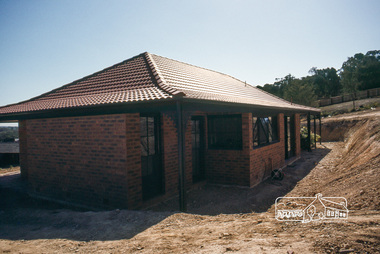
Photograph, House, south elevation and back excavation, April 1980
14 Stokes Place (Lot 83) was the home of Peter and Carla Vermey. The land was purchased in May 1979 and construction commenced September 1979. The home was built by Peter and Carla Vermey after the developer, Macquarie Builders went bankrupt. Sold October 2017 by Morrison and Kleeman Real Estate. Stokes Place was part of the Stokes Orchard Estate which was developed from the break-up of the the orchard owned by Frank Stokes who lived on the northeast corner of Nyora Road and Eucalyptus Road. His daughter Beryl advised that the Shire had levied a rate assessment on individual parcels of land within the orchard which became unaffordable resulting in its sub-division and sell off. The Stokes Orchard Estate was developed by Macquarie Builders in two stages starting with stage 1 in 1976. Stokes Place was part of Stage 2 in 1979. The Estate was bounded between Nyora Road, Eucalyptus Road, Diosma Road and Stokes Place. The original orchard only just reached the left most portions of Stokes Place and did not go fully up to Diosma, rather to just beyond the extant of Stokes Place. Stokes Place was known within the family as "The Oats" as that is where they grew oats. Frank Stokes moved to Eltham c.1945 after visiting Harold Bird to view his orchard, located diagonally opposite Stokes Orchard from the intersection of Eucalyptus Road, Pitt Street and Nyora Road. It was on Harold Bird's recommendation that Frank purchased the land.The Stokes Orchard Estate collection is typical of housing developments of the late 1970s and 1980s. It was one of the earliest estates in Eltham following the nearby Woodridge Estate development.Digital fileScanned by EDHS from 49 x 35mm colour transparencies provided on loanstokes place, eltham, stokes orchard, stokes orchard estate, streets, houses, peter and carla vermey -
 Eltham District Historical Society Inc
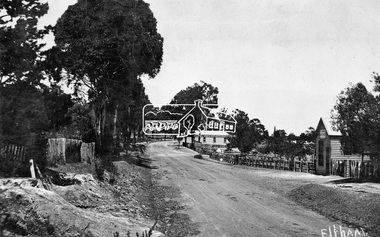
Negative - Photograph, Tom Prior, Main Road near Eltham Railway Station, c.1910
View looking south along Main Road, Eltham from near present day Luck Street. On the immediate right is a fence with the words “Hot Water” painted on it followed by William J Capewell’s butcher shop, then the slaughter yard and saleyards with the entrance access to the railway station. Contained within the saleyards facing the street, a small shelter with the name H.H. Clark upon it. Horace Harold Clark was the son of Eltham State School’s first Head Teacher, David George Clark. As well as being a farmer, he was an Estate Agent and conducted auction sales, presumably from this shelter. The large weatherboard building on the corner (opposite present-day Arthur Street) with signs for Summer Drinks and Hot Water painted on the side is Luther and Ada Haley’s General Store and Bakery, built 1902. This was the first building in what is now Eltham’s present shopping town centre. Haley previously ran the General Store and Bakery on the corner of Main Road and York Street until his lease expired and the premises were bought by Mrs Sarah Burgoyne in 1902. The store later was known as Staff's Store. In the distance approximately mid-way between the Butcher shop and the Bakery are the tops of what appears to be two cypress trees, which could well be the trees in front of the Shillinglaw Cottage facing Main Road. On the eastern (left) side of Main Street is Haley’s Paddock, which was used on occasions for community picnics. Capable of holding 10,000 people, with ample shade and hilly surroundings it was an ideal place for any community gathering such as the State Schools’ Picnic in 1904. Picture dated as c.1910 based on similar picture published in the Weekly Times, Feb. 1912. Kerb and channelling added 1923. Cross Ref: 610 (looking north), 611 (later stage), 613. Same as 705 (though in better condition)This photo forms part of a collection of photographs gathered by the Shire of Eltham for their centenary project book,"Pioneers and Painters: 100 years of the Shire of Eltham" by Alan Marshall (1971). The collection of over 500 images is held in partnership between Eltham District Historical Society and Yarra Plenty Regional Library (Eltham Library) and is now formally known as the 'The Shire of Eltham Pioneers Photograph Collection.' It is significant in being the first community sourced collection representing the places and people of the Shire's first one hundred years.Digital image 4 x 5 inch B&W Neg 120 format B&W negative (spare)shire of eltham pioneers photograph collection, eltham, main road, butcher, eltham railway station, railway station, w.j. capewell, baker, eltham town centre, general store, luther haley, reynolds prior collection, shops, haley's paddock, hot water, m.m. clark, sign, summer drinks, eltham sale yards, eltham slaughter yard, staffs general store -
 Eltham District Historical Society Inc
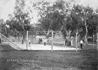
Negative - Photograph, J.H. Clark, Eltham Tennis Court, c.1905
People pose for a photograph at the Eltham tennis court. Four men set to play a doubles match while a group of women look on. The sandy looking court (with weeds growing) is surrounded by wooden posts with wire mesh, in the middle of a park with mature gum trees in the background. The tennis court was situated in Eltham South at Bremner’s Flats (near present day Wingrove Park). The court is approximately the location of the present day small carpark. Main Road can be seen in the background from centre left and Mount Pleasant just above, the intersection just above the centre of court. The photo by J.H. Clark has been taken outside the court. Cross Ref SEPP_0721 of the Lady Premiers for 1909-1910 in which an umpires raised seating platform has been erected and the court surface is more refined with marked lines. The Eltham Lawn Tennis Club was formed on a Saturday evening, the 29th of October, 1898 at a meeting held at the Eltham State school. The meeting was large and representative. Twenty members were enrolled, and eight more have since been added. Officers and a committee were duly elected, and the Treasurer was instructed to purchase the necessary requisites without delay. By the end of the first week in November all the requisites were to hand, two courts were marked out, and practice begun. The formal opening of the Courts of this Club took place on Saturday, November 12, 1898, when 26 members and their friends assembled. After several sets had been contested an adjournment was made for tea provided by the members and nicely laid out under the shade of the trees. Afterwards, sets were again formed and the game was proceeded with in a lively spirit till nearly dark, when all dispersed having thoroughly enjoyed themselves during the afternoon. (Evelyn Observer, and South and East Bourke Record (Vic. : 1882 - 1902), Friday 18 November 1898, page 2) Reproduced on p89 of 'Pioneers & Painters' Photographer: J.H. Clark John Henry Clark was the youngest of three boys born to William Henry Clark (1823-1877) and Maria White (1843-1914). He and his brothers, William Charles Clark (1872-1945), Clement Kent Clark (1874-1912) operated a photography business (Clark Bros.) from 25 Thomas Street, Windsor near Prahran during the period c.1894 to 1914. Following death of Clement in September 1912 and their mother in 1914, the Clark Bros business appears to have dissolved, the premises demolished, and a new house was under construction in 1915. John set up business independently in 1914 operating out of 29 Moor Street, Fitzroy where he is registered in the 1914 and 1915 Electoral Rolls. By 1916 John had relocated to Eltham where he continued his practice as a photographer and took many of the early images around the district of Little Eltham. Around 1930 John changed professions and opened a small cobbler's shop in 1931 near the pond opposite Dalton Street adjacent to the Jarrold family cottage. He never married and continued his profession as a bootmaker from this little shop, maintaining a close relationship with Mrs Jarrold for the rest of their lives. His bootmaker shop remains today beside the Whitecloud cottage and is one of only three remaining shops in the area from the early 20th century. There are a couple of images of Eltham taken by Clark Bros. in the Eltham District Historical Society collection, one such example being Hunniford’s Post Office with Miss Anne Hunniford out front (EDHS_00140 - marked on the back of the print, Clark Bros., 25 Thomas St. Windsor), which would date this image between c.1894 and 1914. Other early images of Eltham taken by John Henry Clark are marked on the face “J. H. Clark Photo” and it is assumed these are dated between 1914 and 1930. It is noted that the Grant of Probate for John H Clark of Eltham South dated 5 April !957 (513/387) records his occupation as "X Photographer".This photo forms part of a collection of photographs gathered by the Shire of Eltham for their centenary project book,"Pioneers and Painters: 100 years of the Shire of Eltham" by Alan Marshall (1971). The collection of over 500 images is held in partnership between Eltham District Historical Society and Yarra Plenty Regional Library (Eltham Library) and is now formally known as the 'The Shire of Eltham Pioneers Photograph Collection.' It is significant in being the first community sourced collection representing the places and people of the Shire's first one hundred years.Digital image 4 x 5 inch B&W Negshire of eltham pioneers photograph collection, bremner's flat, eltham, eltham tennis court, j.h. clark photo, pioneers and painters, tennis court, wingrove park, 1905, eltham lawn tennis club, main road, mount pleasant road -
 Eltham District Historical Society Inc
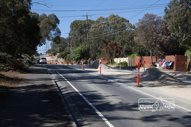
Photograph, Peter Pidgeon, Bolton Street upgrade just south of Withers Way, Eltham, 13 November, 2017, 13/11/2017
... Bolton Street upgrade just south of Withers Way, Eltham, 13... melbourne North bound lane closure. bolton street bolton street ...North bound lane closure. Born Digitalbolton street, bolton street upgrade, eltham, streets, withers way -
 Eltham District Historical Society Inc
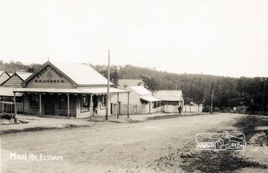
Photograph postcard, Main Road, Eltham; postcard dated 4 November 1909
Looking south on the Main Road from about opposite Franklin Street near the Living and Learning Centre. The Corn Store of W.B. Andrew stood on the south side of the intersection of Franklin Street and Main Road now occupied by Cafe Zen Den.Digital file only Postcards scanned from the collection of Michael Aitken on loan to EDHS, 13 Feb 2018michael aitken collection, postcards, eltham, main road, cafe zen den, corn store, w.b. andrew -
 Eltham District Historical Society Inc
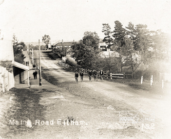
Photograph postcard, Main Road, Eltham
Looking south on the Main Road from about opposite Franklin Street near the Living and Learning Centre. The Corn Store of W.B. Andrew stood on the south side of the intersection of Franklin Street and Main Road now occupied by Cafe Zen Den.Digital file only Postcards scanned from the collection of Michael Aitken on loan to EDHS, 13 Feb 2018michael aitken collection, postcards, eltham, main road -
 Orbost & District Historical Society
programs, 1961
The Snowy River Shire was a local government area in the Australian Alps region of New South Wales, Australia from 1939 until May 2016. It was named after the Snowy River that runs through it. Prior to 1936, it had been named as Dalgety Shire since establishment in 1906. This opening of the Monaro - Gippsland Road took place on 4th May 1961. There had long been a movement in Monaro for the construction of a road to connect Monaro and Gippsland, via Inglebyra and Black Mountain. The only track was for stock, made by pioneers many years ago, and it was very circuitous. It was stated at a meeting at Dalgety that the road would open up large areas for settlement for grazing, and for timber suitable for bridgé building. The road would assist stock deal ing between Monaro and Gippsland. It would also considerably shorten the distance from Victoria for tourists visiting Canberra and Kosciusko. A committee was formed to put the proposal before the Dalgety Shire Council in the 1930s.This item is a useful research tool.Four copies of a road opening program. It has black print on white. There are black / white photographs, historical details and details of the official opening.program monaro-road snowy-river-shire -
 Orbost & District Historical Society
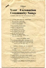
program, 1953
This program was produced by the Snowy River Mail for a community singalong held in Orbost on Tuesday June 2 1953 to celebrate the coronation of Queen Elizabeth 11. In June 1953 , Elizabeth II was crowned Queen of the United Kingdom, Canada, Australia, New Zealand, South Africa, Ceylon (now Sri Lanka), and Pakistan, and became the Head of the Commonwealth. The coronation of Queen Elizabeth II as monarch took place on 2 June 1953. Elizabeth ascended the throne at the age of 25, upon the death of her father, King George VI, on 6 February 1952, and was proclaimed queen by her various privy and executive councils shortly afterwards. The coronation took place more than a year later because of the tradition that holding such a festival is inappropriate during the period of mourning that follows the death of a monarch. This community event was typical of the general feeling of respect and admiration felt by the rural communities towards the British Royal Family. This item reflects the significance of monarchy for Australia and the constitutional history of Australia.The item reflects the interest in the royal family to Australians at this time as well as the general feeling of respect and admiration felt by the rural communities towards the British Royal Family.A white paper program with the words of songs printed in black. There is a rust mark from a metal staple in the top left corner. It is titled "Your Coronation Community Songs".queen-elizabeth-11 royalty community-event-orbost souvenir-program -
 Orbost & District Historical Society
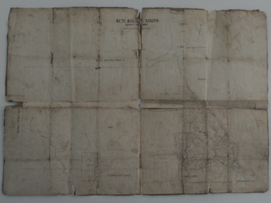
map, Bete Bolong South, March 8 1910
Orbost was at first included in the Bairnsdale Shire from 1882 and was later part of the Tambo Shire. This is a useful research toolA paper shire map of Bete Bolong South, County of Tambo.documents-map-bete-bolong tambo-shire -
 Orbost & District Historical Society
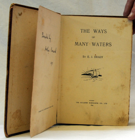
book, The Ways of Many Waters, 1899
This book of poetry by E. J. Brady was originally published by the Bulletin Newspaper Company (Sydney) in 1899,Later it was reprinted by Thomas C. Lothian (Melbourne) in 1909, and by the Standard Publishing Company (Melbourne) in 1913.] E. J. Brady was an Australian poet. He was born at Carcoar, New South Wales, and was educated both in the United States and Sydney. He worked as a wharf clerk, a farmer, and journalist, and edited both rural and city newspapers This book is culturally important as Edwin James Brady represented the Bulletin school of the 1890s. The Bulletin was very popular with rural bush workers and selectors and became known as ‘the bushman’s bible’. It encouraged contributions of poetry, short stories and cartoons from its readerswho included miners, shearers and timber-workers from all over Australia. Some of this content was high quality and many of Australia’s important writers had their start with The Bulletin which became know as the ‘Bulletin School’ of literature.A small 155 pp fabric covered brown book with a very faded picture of a boat sailing toward a sunset on the front cover.poetry literature brady-edwin-james the-ways-of-the-waters -
 Orbost & District Historical Society
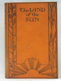
book, Butler & Tanner, The Land of the Sun, 1924
This is the author's account of life in Northern Queensland. Edwin James Brady was an Australian poet. He was born at Carcoar, New South Wales, and was educated both in the United States and Sydney. He worked as a wharf clerk, a farmer, and journalist, and edited both rural and city newspapers. Brady established a writers' and artists' colony at Mallacoota, in 1909, and he continued to live there until his death in 1952. E. J. Brady was a leading figure of Australian literature. He has an association with Mallacoota, a small town in the East Gippsland region of Victoria, Australia. A 303 pp book with a hard back cloth covered bright orange cover. It is titled in black print " The Land of the Sun" and has black print illustrations of crops and the sun. It contains black/white plates and a fold-out map of Queensland.brady-edwin-james book--the-land-of-the-sun queensland-northern -
 Orbost & District Historical Society
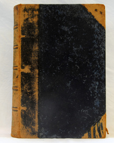
book, History of New South Wales, 1889
George Burnett Barton (1836-1901), lawyer, journalist and historian, was born on 9 December 1836 in Sydney. He practised journalism rather than law for which he had qualified in 1860. This is Volume 1 and covers the proposals for colonising New South Wales, the transportation and the early years of Governor Phillip.This is a detailed history of New South Wales compiled from original records and is a very useful research tool.A hard cover 625 pp book with a dark brown cover. On the spine the text is gold. It is titled, "History of New South Wales from the Records, Volume 1". It contains illustrations, facsimiles, maps, portraits and detailed historic information.Vol 1 1783-1789 Bartonnew-south-wales-history convict-settlement phillip-arthur barton-george-burnett -
 Orbost & District Historical Society
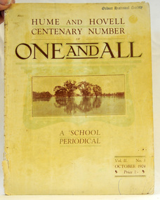
magazine, Clothier & Co, One And All, 1924
This magazine was circulated amongst the pupils, parents, and teachers of the Beechworth Inspectorate, North-East Victoria. This magazine is Vol. 2, no. 3 (Oct. 1924), Hume and Hovell Centenary Number.School magazines were the forerunners of today's school newsletters and were generally published annually. They are contemporary records of the students and staff of the school and usually contain examples of the students' work.This one, published to commemorate the centenary contains information on the Hume and Hovell expedition the purpose of which was to find new grazing land in the south of the colony, and also to find an answer to the mystery of where New South Wales's western rivers flowed. At the centenary of Hume and Hovell exploration in 1924 a committee was formed to co-ordinate and organise local celebrations along the route from Albury to Corio Bay. A roadside cairn was unveiled near Beechworth.A stapled school magazine with a cream coloured cover. It has an illustration of a river and trees reflected in the water on the front. The title, "ONE AND ALL" is at the top in black print. It has " Hume and Hovell Centenary Number" above the title.education-beechworth school-magazine-one-and-all -
 Orbost & District Historical Society
black and white photograph
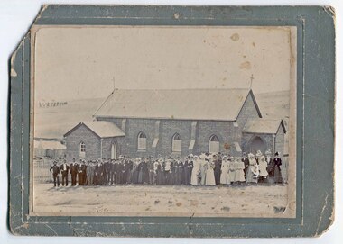
This is possibly a wedding photograph related to an Orbost family.A black / white photograph, on a grey buff card, showing a large group of people, probably a wedding party, outside a brick church in Bega, New South Wales.on front at bottom - "Wood - Bega"photograph-church-bega -
 Ringwood and District Historical Society
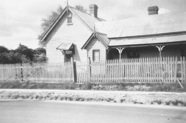
Photograph, Ringwood State School schoolmaster's residence. 1945
The residence was relocated from school number 2242 in Heatherdale Road (Mitcham) south of the railway line to this site in Ringwood Street opposite Charter Street where it adjoined the school when it opened at the corner of Maroondah Highway in 1889. For Rear View of the residence see record 6855Written below photograph, "Old schoolmasters residence - Ringwood St. - 1945". Written on back of one of smaller copies, "Was used as a residence by Mr. D. Broben(?) H.? No2977 for many years. Photo taken by Miss Joyce Russell for J. K. McCaskill. Bedford Rd." -
 Ringwood and District Historical Society
Photograph, South-western view from Marcel Street North Ringwood over Jull Parade to Oban Road - 1981. North Ringwood Sports Reserve is on the left, above the corner of Jull and Oban Roads
... . Looking south-west from Marcel Street North Ringwood over Jull... reads, "E620. N1. 1981. Looking south-west from Marcel Street ...Writing on back of photograph reads, "E620. N1. 1981. Looking south-west from Marcel Street North Ringwood over Jull Road to Oban Road. North Ringwood Sports Reserve centre left above corner of Jull and Oban Roads". -
 Ringwood and District Historical Society
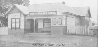
Photograph, Coach and Horses Hotel, Whitehorse Road, Ringwood. 1924
Appears to be reproduction of newspaper photograph. South Side of highway.Written below one photograph, "Photo of Coach and Horses Hotel, corner of White Horse Road and Madden Street. Enter Estate at Madden Street". 1924. -
 Ringwood and District Historical Society
Photograph, Coach and Horses Hotel, Ringwood circa 1940
Black and white photograph of Coach and Horses Hotel in Maroondah Highway, west of New Street, now adjacent to Eastlink Freeway, on northern side. There are two duplicate photos. Certainly the photo was taken post-1940 as the previous Coach & Horses Hotel, on the south side, burnt down in 1940. The telephone pole indicates that era, with limited lines. The style of the building was Art Deco that generally existed in the 1920s-1930s but did continued in Australia in the 1940s. The building has the appearance of being newly-built. Was H4, in the old cataloguing system. -
 Ringwood and District Historical Society
Photograph, Building the old Ringwood baths in Ringwood Street. 1934
... baths in Ringwood Street. Looking south along space behind..., "Building the old Ringwood baths in Ringwood Street. Looking south ...Black and white photograph. 2copies-1 large, 1 small.Typed below large photograph, "Building the old Ringwood baths in Ringwood Street. Looking south along space behind houses in Ringwood St. Trees in background are where Eastland now stands. 1934" -
 Ringwood and District Historical Society
Photograph, New market - Bond St. entrance to the new street across Charters Seymour Streets, Ringwood 1982
... . entrance to the new street across Charters Seymour Streets. Looks... Charters Seymour Streets. Looks south." New market - Bond St ...Written on back of photograph, "E661. 8/1/82. Bond St. entrance to the new street across Charters Seymour Streets. Looks south." -
 Ringwood and District Historical Society
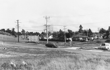
Photograph, Freeway site. Virgin bush. Ringwood Street looking west along south side Mullum Creek. Ringwood Late 1980
... Freeway site. Virgin bush. Ringwood Street looking west.... Virgin bush. Ringwood Street looking west along south side.... Ringwood Street looking west along south side Mullum Creek ...Written on back of photograph, "Late '80. Freeway site. Virgin bush. Ringwood Street looking west along south side Mullum Creek." -
 Orbost & District Historical Society
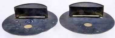
shields - blackout, Swan, Wally, WW11
By 1941, the threat of Japanese invasion caused restrictions to daily life. Blackouts became the norm. To prevent identification from enemy planes all lights had to be turned down, including car headlights that had to be covered to minimize light exposure. In Australia more relaxed regulations led to the Australian air raid precautions being dubbed the “brownout”. These shields limited the amount of light emitted by a vehicle. To drive at night without them was an offence; however, the increase in road accidents led to the removal of headlight masks everywhere in Australia south of Rockhampton from 15 February 1943.These shields, though not rare, evoke a period of restrictions, fear, rationing and confinement.Pair of handmade car light blackout shields. Black round metal with scoop at front as well as small glass partition.shields-blackout ww11 transport-motor-vehicles -
 Orbost & District Historical Society
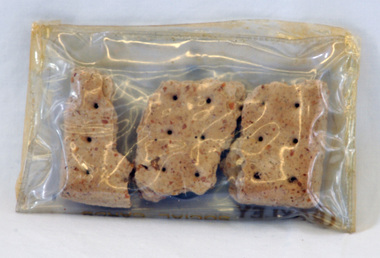
biscuit rations, c. 1899
These biscuits were supposedly issued to Jacob Perry when he served in the Boer War in South Africa in 1899. Jacob Perry was a member of an early family in Orbost and these biscuits were donated by George Perry. Hard tack biscuits were part of a soldier's individual ration in the Boer War and were so hard that they were often soaked in water before consumption if this was possible. Made of 13 parts flour to one part of water, the biscuits were slowly dried in the baking process, rendering them so hard that they deterred attacks from weevil pests and allowing them to be transported with little breakage. Hard ration biscuits were a staple of soldier's diets. This item is an example of an early ration supplied to soldiers serving overseas.Three dry biscuits, hard tack, roughly rectangular shape and with 6 prick holes.army-biscuits boer-war-biscuits -
 Orbost & District Historical Society
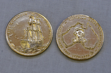
coins, Victorian Local Government, 1970
These coins were made as part of the 200 year celebration of Captain James Cook's voyage on the HM Endeavour and the first sighting of Australia at Point Hicks in 1770. These two coins were presented to Orbost Historical Society by the Orbost Branch of the Bank of New South Wales in 1970.These coins were made as part of the 200 year celebration of Captain James Cook's voyage in 1770 and reflect the importance of that historic event.Two silver coloured coins. On one face is the image of a sailing ship and the words HM BARK ENDEAVOUR OFF POINT HICKS and on the other face is a map of Australia with a head portrait of Capt. Cook in its centre, and the words CAPTAIN JAMES COOK 1770-1970 VICTORIAN LOCAL GOVERNMENT around the edge.as abovecoins celebratory-coins captain-cook australia-discovery -
 Orbost & District Historical Society
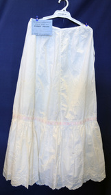
petticoat, Cowell, Alice, 1914
Handmade by Alice Cowell as an entry for the annual Bombala (southern New South Wales) Show.This item is an example of a handcrafted item and reflects the needlework skills of women in the first half of the 20th century.A white machine-made petticoat with hand embroidery and pink ribbon threaded around middle. It has broderie anglaise along scalloped edge and comes with a blue certificate for First prize at the Bombala Annual Show.petticoat costume female-underwear handcrafts dress-making -
 Orbost & District Historical Society
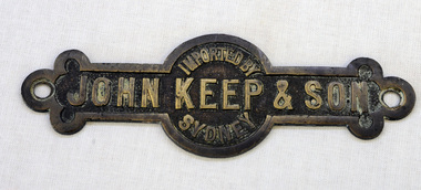
label
The hardware firm of John Keep and Sons, Ltd., was founded in 1853 by Mr. John Keep. Mr. John Keep started the business on the south-western corner of George and King streets in Sydney. In 1883 the firm removed to Clarence and King streets.A brass metal label with "Imported by John Keep & Son, Sydney:" imprinted on it. label commerce keep-john -
 Orbost & District Historical Society
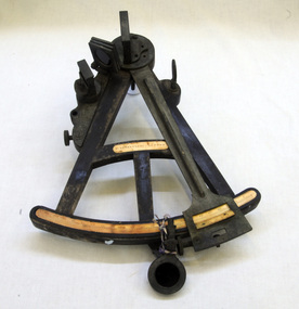
sextant, W. Sutherland
RIDGE PARK, Length: 65.2 m.; Owned by H. Simpson & Sons; Built at S. P. Austin & Sons in 1878. Registered at Adelaide. On 10 February 1881, RIDGE PARK (Capt. Heslop) was on voyage from Adelaide to Sydney with a cargo of brandy, wine and flour, when she was lost after running aground.Beware Reef is located south east of Cape Conran in east Gippsland. This is the sextant from the Ridge Park which, on10 February 1881, was wrecked on Beware Reef , just south of Cape Conran in east Gippsland. An old wooden sextant from the ship, Ridge Park. It is black with yellow measuring stripes.sextant maritime navigational -
 Orbost & District Historical Society
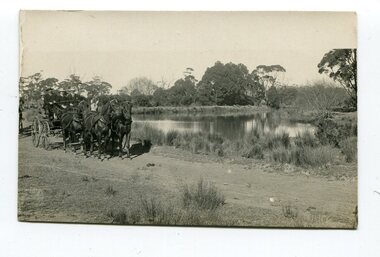
black and white photograph, late 19th - early 20th century
This photograph was taken at the junction of the Snowy and Brodribb Rivers. The Snowy River starts in New South Wales on the slopes of Mt Kosciuszko, Australia’s highest mountain, in New South Wales. It flows into Bass Strait at Marlo in Victoria. The Brodribb River is a tributary of the Snowy which enters the estuary at Marlo. This is a pictorial record of a road in Marlo near Orbost in the late 19th-early 20th centuries. It also depicts the transport used at that time.A black / white photograph of four men in suits seated in a horse - drawn buggy on a dirt road alongside a creek or river. There appears to be another horse - drawn vehicle behind them.on back - "at the Brodribb - Snowy junction. this road was corduroy (packed logs of tea trees?)brodribb-river snowy-river marlo transport-horse-drawn -
 Orbost & District Historical Society
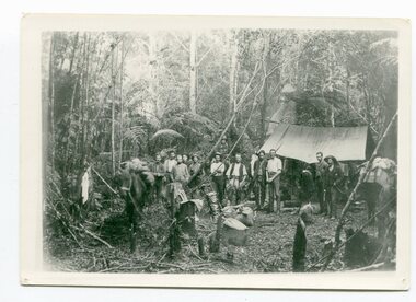
black / white photograph, 1897
Link with item 1178. This is a surveyors' camp in the McCulloch Ranges, Murrangowar, April, 1897. Included in the photograph are: L. Thorn; Pearson; L. Coburn, Clem Bates; Sam Blacklock with a packhorse. They were surveying for a road or railway. Surveyors were among the first European settlers to arrive in Australia. A Surveyor-General was present on the First Fleet, as well as the first two ships which landed in South Australia. These men were issued with instructions to record observations in a journal that included the country’s general appearance, its soil, flora and fauna and the customs and language of local inhabitants. The conditions they worked in were harsh and they embarked on journeys with drays carrying cumbersome surveying and camping equipment, spending months camping out in the bush and mapping the land. It was not until well into the second half of the nineteenth century that the professional training of surveyors became mandatory in Australia.This is a pictorial record of a surveyors' camp in the late 19th century.A black / white photograph of a group of men standing in front of a tent / camp in a dense bush setting.surveyor's-camp-mccullochs-ranges-murrangowar land-settlement -
 Orbost & District Historical Society
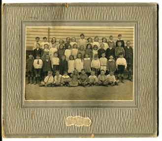
black and white photograph, C 1920
Phyllis May Waller was born Orbost in 1912. Her father-was Frank Hale Waller and her mother -Sarah Elizabeth Clancy. Phyllis married Clive Howell Crawford Pasco in 1934 (Clive was born 1908 at Prahran, and died in 1971 at South Melbourne). "The 19th of March 1886 proved an important day in the lives of many early settlers in the Orbost area, because on this day the Orbost State School opened. The fact that the school had first operated temporarily in a leased building, and on a half-time basis with SS2745 Jarrahmond, did not dampen the enthusiasm of the local inhabitants as they saw their offspring commence their education under the guidance of HT Campbell Mackay. However he remained in charge only until 12th of May 1886. The second HT, John Rowe, served until 1908. On 30th of June 1887, a portable room was provided; it being brought to the area by schooner. The school now had accommodation for 30 pupils; the teacher's welfare was considered because quarters of two rooms were attached. As the population increased so did the needs of the school. This was reflected in the provision of a larger classroom in 1898. During 1910-11 the first approaches were made to the Department for the establishment of a HES in Orbost and this became a reality in 1912. Orbost HES supplied post-primary education in the district until a high school was built in 1948. When fire destroyed the school in 1941 local halls were used as classrooms until a new school was built. Work was quite rapid and a new brick structure was opened by the Hon. A. E. Lind, MLA, on 13th of February 1942. This new building was a fine type of school of which both the pupils and the HT Leslie Collins were indeed proud. But Orbost continued to develop and the new school was soon overtaxed. This resulted in the erection of two Bristol classrooms in 1947. By 1950, when the school population had reached 500 pupils the opening of the new school at Orbost North was welcomed by all concerned. In 1963 the Department purchased land diagonally opposite the school and developed it as a playing area. In 1965 two LTCs were opened in November, and in October 1968 the Brodribb School building was moved to SS2744 Orbost for use as a general purpose room."This item is associated with the history of education in Orbost. It is also associated with the Waller family, early settlers in Orbost.A black / white photograph on grey card. Against a wooden building are four rows of young children. The front row of the youngest children is sitting with crossed legs.The back three rows are tiered. the children appear to be dressed in their best clothes with many of the boys wearing ties. There is a photographer's label at the bottom.on back written by older son -"Orbost State School Approx. 1920 Mum (Phyllis May Waller) 6th from left 2nd back row"waller-phyllis-may