Showing 126749 items
matching main-road
-
 Greensborough Historical Society
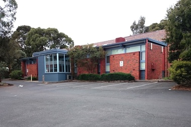
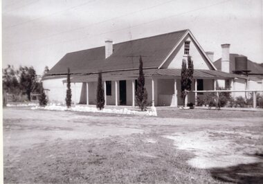
Photograph - Digital image, Marilyn Smith, Greensborough Road Surgery, 10/07/2016
The Greensborough Road Surgery moved to this location in 1985 in response to increased demand for services. This building was built in the late 1950s.Digital copy of colour photographgreensborough road surgery, medical centre -
 Greensborough Historical Society
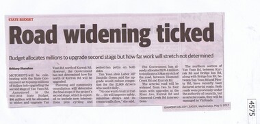
Newspaper Clipping, Diamond Valley Leader, Road widening ticked, 03/05/2017
Motorists will be celebrating with the State Government set to pump millions of dollars into upgrading the second stage of Yan Yean Road.News article 1 page, black text.yan yean road, victoria, traffic -
 Stawell Historical Society Inc
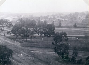
Photograph, Original Stawell Show Grounds in Lake Road -- 2 Photos
Scene - Two prints of Original Stawell Show Grounds in Lake Road (2) enlargements from Photo 3797stawell -
 Whitehorse Historical Society Inc.
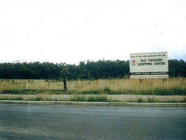
Photograph, Old Orchard Shopping Centre Blackburn Road, 17/11/2010 12:00:00 AM
The Old Orchard Shopping Centre, situated on the corner of Springfield and Williams Road, Blackburn North, was opened in October 1965.Coloured photograph of the land on which the Old Orchard Shopping Centre was built. Sign on right 'Old Orchard Shopping Centre - A Lend Lease development.'old orchard shopping centre, blackburn, shopping centres -
 Mt Dandenong & District Historical Society Inc.
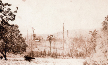
Photograph, Across the Creek to Falls Road c1920, c1920
Mt Dandenong. Cow in paddock, looking to two houses in Falls Road. One probably belonging to a Mr. Mason.Sepia photograph of rural scene. Two cows and calf in foreground with houses, crops and trees in background.mount dandenong, falls road, cow, mason -
 Stawell Historical Society Inc
Photograph, Salinger's House in Great Western with front on view from road shows Winery, Shed & the residence at the rear 1959
Salinger's House Great Western. Front on View from road shows Winery and Shed. 1959 Residence at Rear.stawell -
 Surrey Hills Historical Society Collection
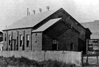
Photograph, Rechabite Hall (dem) in Canterbury Road
The photo is of the Rechabite Hall (dem) in Canterbury Road. It was in the vicinity of the Post Office in 1920s. It was used for many public functions.A black and white photograph of a large building (hall) with a noticeboard at the front.rechabite hall, canterbury road, surrey hills, ioor, independent order of rechabites, 1925 -
 Greensborough Historical Society
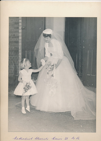
Photograph - Digital Image, Partington Family, Wedding of Elinor Partington and Kevin Rowe, 1960_05
The marriage of Elinor Partington to Kevin Rowe at the Greensborough Methodist Church, Main Street, May 1960. Left to right: Elinor Partington, Kevin Rowe.One of a series of Partington wedding photographs taken at the old Methodist Church.Digital copy of black and white photographelinor partington, kevin rowe -
 Greensborough Historical Society
Photograph - Digital Image, Partington Family, Wedding of Faye Partington and Eric Fort 1957, 1957_
The marriage of Faye Partington to Eric Fort at the Greensborough Methodist Church, Main Street, 1957. Left to right: Karin Anderson [child], Faye Partington.One of a series of Partington wedding photographs taken at the old Methodist Church.Digital copy of black and white photographpartington family, faye fort (nee partington) -
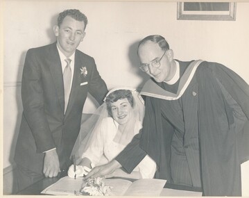 Greensborough Historical Society
Photograph - Digital Image, Partington Family, Wedding of Faye Partington and Eric Fort 1957, 1957_
The marriage of Faye Partington to Eric Fort at the Greensborough Methodist Church, Main Street, 1957. Faye and Eric Fort sign the register with Reverend Watson.One of a series of Partington wedding photographs taken at the old Methodist Church.Digital copy of black and white photographpartington family, faye fort (nee partington), eric fort -
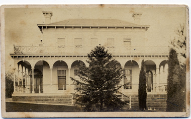 Kew Historical Society Inc
Photograph - 'Clutha', Studley Park Road, 1860-1890
Clutha was the home of John Carson, the second mayor of Kew. Leonard Terry designed the house for him in 1856. Terry was the architect of the Melbourne Club (1858), the former London Chartered Bank (1861), Lothian Terrace in Carlton (1865), and the ES&A Bank in Hawthorn (1873). The commission for Clutha was won three years after Terry’s arrival in Victoria.An extremely rare photograph of a major residential architectural commission of Leonard Terry. The photograph of the house has statewide significance as the home of the Victorian pioneer and businessman, John Carson. A rare, nineteenth century photograph of ‘Clutha’ in Studley Park Road, Kew. The sepia-toned photograph is of the front of the house, with its bluestone foundations and its second storey balcony. A real estate advertisement in 1875 described the house as: 'First-class family mansion, and about 8½ acres of pleasure grounds and fruit garden. The house, erected under the plans and supervision of Mr. Leonard Terry, is most substantially built of brick, stuccoed, on solid bluestone pediment, forming a noble basement story, large entrance hall, and lobby, with conservatory on the left. *** A wide verandah and balcony, erected on cast-iron columns, runs round the house, the views from which are perhaps unequalled in extent and beauty in the neighbourhood of the city, commanding the bay, shipping, Mount Macedon, and Dandenong Ranges. Th e whole forming a most complete gentleman's residence, no expense having been spared in its erection and comfortable finish.'"Clutha West Side Studley Park Road Kew / Clutha West Side"clutha, john carson, leonard terry -
 Glenelg Shire Council Cultural Collection
Photograph - Photograph - Main Breakwater Construction, 28/07/1953
Port of Portland Authority ArchivesBack: Purple PHT Stamp Print No 4/20 Date Taken 28/7/53 Subject Main Breakwater West Sideport of portland archives -
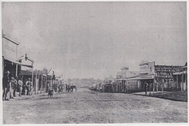 Rutherglen Historical Society
Image, 1900 Approximate
Donated by Mr Greg Thomson, a former resident of RutherglenBlack & white photographic reproduction, unframed, laminated. This photograph is of Main St Rutherglen facing West. In centre of photograph, right at the end of the street can be seen, faintly, the building called Seppelts Cellars (later Jolimont Winery, Now (2017) Tuileries). Building on right had side with "saddler" painted on it, is the building that became the Rutherglen Sun officeOn back of photo: "Main St Rutherglen - facing west"main street, seppelts winery, jolimont winery, tuileries -
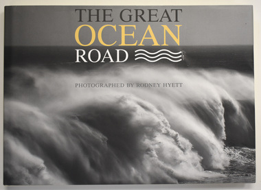 Warrnambool and District Historical Society Inc.
Book, Rodney Hyett, The Great Ocean Road, 2013
A book containing Great Ocean Road PhotographsThis is a book of 144 pages. The cover is buff-coloured with an embossed title. The dust cover has a black and white photograph and a map with white, yellow and black printing. The pages contain printed text and black and white and colour photographs amd mapsnon-fiction A book containing Great Ocean Road Photographsgreat ocean road, rodney hyett photographer -
![Photograph - Digital Image, Ray White Greensborough, 3 St Helena Road Greensborough [veranda and views], 2017_](/media/collectors/4f729f5697f83e03086015b8/items/5d3c002521ea6715d01d7aa7/item-media/5d3c004b21ea6715d01da9f2/item-fit-380x285.jpg) Greensborough Historical Society
Greensborough Historical SocietyPhotograph - Digital Image, Ray White Greensborough, 3 St Helena Road Greensborough [veranda and views], 2017_
Exterior photographs of the house at 3 St Helena Road Greensborough (corner Diamond Creek Road), showing the veranda and views over Greensborough. The house was built in 1920. These photographs are from the Ray White sales brochure 2017. The 4 bedroom property sold in December 2017 for $900,000; previous sales: April 2009, $600,000; June 1981, $36,500; June 1976, $32,500. Digital copy of 4 colour photographs.st helena road greensborough, diamond creek road greensborough -
![Photograph - Digital Image, Ray White Greensborough, 3 St Helena Road Greensborough [interiors], 2017_](/media/collectors/4f729f5697f83e03086015b8/items/5d3c01c421ea6715d01f3f5c/item-media/5d3c01ea21ea6715d01f7078/item-fit-380x285.jpg) Greensborough Historical Society
Greensborough Historical SocietyPhotograph - Digital Image, Ray White Greensborough, 3 St Helena Road Greensborough [interiors], 2017_
Interior photographs of the house at 3 St Helena Road Greensborough (corner Diamond Creek Road), showing lounge, dining, kitchen and hallway. The house was built in 1920. These photographs are from the Ray White sales brochure 2017. The 4 bedroom property sold in December 2017 for $900,000; previous sales: April 2009, $600,000; June 1981, $36,500; June 1976, $32,500. Digital copy of 8 colour photographs.st helena road greensborough, diamond creek road greensborough -
 Coburg Historical Society
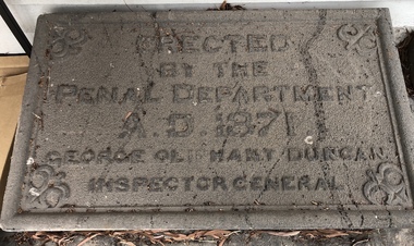
Artwork, other - Plaque (intended) for Murray Road Bridge, Bluestone Plaque intended for Murray Road Bridge, 1871
The plaque was originally intended for the Murray Road Bridge. The Murray Road Bridge is of state historical and architectural significance. With the Newlands Street Bridge it is one of a pair of bluestone bridges constructed by prison labour in Coburg and is situated within the immediate vicinity of the Pentridge Prison. The bridge has one of five largest spans of stone bridges built in Australia, of which at least three survive. (VHR)BluestoneErected by the Penal Department A.D. 1871 George Oliphant Duncan Inspector General -
 Melbourne Legacy
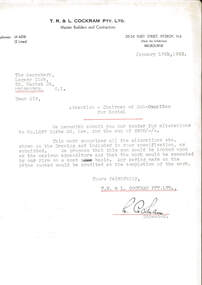
Letter, Alterations to 1267 Burke Road
A letter dated 18 January 1943 from builders to the Legacy Club submitting their tender for alterations to 1267 Burke Road for the sum of £408. The property mentioned at 1267 Burke Road was named Holmbush and was the first hostel for children that Legacy started and operated from April 1943. It was later renamed Blamey House after another hostel called Blamey House was closed.A record of the tender process to make changes to Holmbush to become a residence for children.White quarto letterhead, black type, two hole punched, a letter about alterations to be made at Holmbush.Signed in ink by L. Cockram of T.R. and L. Cockram Pty Ltd, Master Builders and Contractorsresidences, renovations, holmbush -
 Melbourne Tram Museum
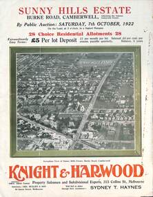
Ephemera - Real estate sale, Knight Harwood, "Sunny Hills Estate" - Burke Road Camberwell, Oct. 1922
Pamphlet advertising the sale of land at the "Sunny Hills Estate" Burke Road Camberwell 7-10-1922. Gives terms of sale, photos showing a nearby shopping centre, recently constructed houses, and plan of the subdivision. Land prices have been written in for each block on the pamphlet. Has a photo featuring Camberwell Junction with a tram, and Burke Road view with trams. Demonstrates the style of land sale pamphlet including the availability of tram services to prospective purchasers.Pamphlet - folded - printed in three colours of cream coloured paper with photographs and plans.has ink notes re sale price and notes.sale of land, trams, real estate, burke road, camberwell, sunny hills estate -
 Melbourne Tram Museum
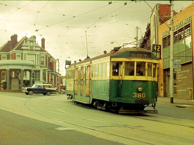
Photograph - Digital Image, Dick Jones, W2 380, at the intersection of High St and Mont Albert Road Kew, Sep. 1966
Digital image of W2 380, at the intersection of High St and Mont Albert Road Kew, Kew Junction. Kew Post Office is in the background along with a Bank of NSW building. Tram showing route 42, City. Photo by Dick Jones - reference - 380_KewPO_DickJones_6609x34Pe.11trams, tramways, w2 class, kew junction, route 42, mont albert rd, high st, tram 380 -
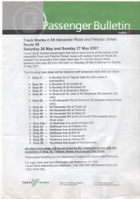 Melbourne Tram Museum
Pamphlet, Yarra Trams, "Passenger Bulletin - Track works in Mt Alexander Road and Fletcher St Route 59", May. 2007
Pamphlet - A4 sheet single sided, titled "Passenger Bulletin - Track works in Mt Alexander Road and Fletcher St Route 59" for dates 26/5 to 27/5 2007, published by Yarra Trams, gives details of bus replacement and tram stops.trams, tramways, yarra trams, essendon, trackwork -
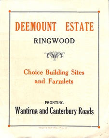 Ringwood and District Historical Society
Flyer, Subdivisional Land Sale advertisement - Deemount Estate, Ringwood, Vic. - c.1950
Double sided folded page with black and orange advertisement and blueprint for Deemount Estate fronting Canterbury and Wantirna Roads, Ringwood, with handwritten price list and terms of sale.Subdivision includes Canterbury Road, Wantirna Road and Maidstone Street. -
The Ed Muirhead Physics Museum
Photograph, Cyclotron accelerator
Builit in 1950s and used till the mid 1970s within the Physics Department used in Melbourne. John Rouse and David Caro was involved in the construction.Black and white photo of cyclotron (nuclear physics accelerator): Main switchboard. Sticky typed labels on back from top and left to right: “MAIN SWITCHBOARD” Handwritten in pencil on upper left hand corner: “9” Handwritten in pen on bottom right hand corner: “AC power in from substation” -
Whitehorse Historical Society Inc.
Document, James Cowley Morgan Fisher, n.d
Document re James Cowley Morgan Fisher, Thomas Bowen and Charles Carter .Document re James Cowley Morgan Fisher, Thomas Bowen and Charles Carter and land at Dorset & Canterbury Road and LL Road (Boronia Road) and Canterbury Road.Document re James Cowley Morgan Fisher, Thomas Bowen and Charles Carter .fisher, james cowley morgan, bowen, thomas, carter, charles, l l vale road vermont, boronia road, vermont, vermont, dorset road, bayswater, canterbury road, vermont, bayswater -
Whitehorse Historical Society Inc.
Document, Roads, 1/02/1937
Claims by Shire of Blackburn and Mitcham for reimbursement from Country Roads board for amounts expended on the main Healesville (now Whitehorse) and Burwood Roads, February 1937.burwood highway, healesville road, shire of blackburn and mitcham, victoria. country roads board, roads and streets, whitehorse road, nunawading -
 Eltham District Historical Society Inc
Album - Photograph, J.A. McDonald, Salters Rush Road, Smiths Gully, Aug. 1962
Salters Rush Road, Smiths Gully Burnt out culvert following bush fires 15-16 Jan. 1962Record of various Shire of Eltham infrastructure works undertaken during the period of 1952-1962 involving bridge and road reconstruction projects, sometimes with Eltham Shire Council Project Reference numbers quoted. It was during this period that a number of significant improvements were made to roads and new bridges constructed within the shire that remain in place as of present day (2022). In many situations, the photos provide a tangible visible record of infrastructure that existed throughout the early days of the Shire. The album was put together by or under the direction of the Shire Engineer, J.A. McDonald.H941 stamped on reverse (film processing #)infrastructure, shire of eltham, bridge construction, road construction, 1962-08, bushfires, salters rush road, smiths gully, victorian bushfires - 1962 -
 Eltham District Historical Society Inc
Album - Photograph, J.A. McDonald, Black Cameron Road, Smiths Gully, Aug. 1962
Black Cameron Road Bridge over Salters Rush Creek following bush fires 15-16 Jan. 1962Record of various Shire of Eltham infrastructure works undertaken during the period of 1952-1962 involving bridge and road reconstruction projects, sometimes with Eltham Shire Council Project Reference numbers quoted. It was during this period that a number of significant improvements were made to roads and new bridges constructed within the shire that remain in place as of present day (2022). In many situations, the photos provide a tangible visible record of infrastructure that existed throughout the early days of the Shire. The album was put together by or under the direction of the Shire Engineer, J.A. McDonald.H941 stamped on reverse (film processing #)infrastructure, shire of eltham, bridge construction, road construction, 1962-08, bushfires, victorian bushfires - 1962, black cameron road, smiths gully -
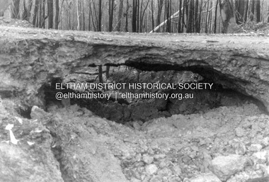
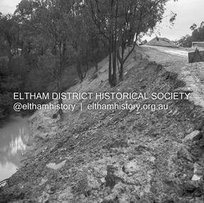 Eltham District Historical Society Inc
Negative - Photograph, J.A. McDonald, Heidelberg-Kinglake Road, Sep 1959
Job 56M430 Contractor Hone Wash over road due to blocked table drain caused this wash out on embankmentRecord of various Shire of Eltham infrastructure works undertaken during the period of 1952-1962 involving bridge and road reconstruction projects, sometimes with Eltham Shire Council Project Reference numbers quoted. It was during this period that a number of significant improvements were made to roads and new bridges constructed within the shire that remain in place as of present day (2022). In many situations, the photos provide a tangible visible record of infrastructure that existed throughout the early days of the Shire. The album was put together by or under the direction of the Shire Engineer, J.A. McDonald.infrastructure, shire of eltham, bridge construction, 1959-09, heidelberg-kinglake road, road construction -
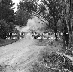 Eltham District Historical Society Inc
Negative - Photograph, J.A. McDonald, Heidelberg-Kinglake Road, Oct. 1959
Job 56M431 Contractors Wolf and Wood Yow Yow Creek Bridge Bypass road and bridge finished October 1959Record of various Shire of Eltham infrastructure works undertaken during the period of 1952-1962 involving bridge and road reconstruction projects, sometimes with Eltham Shire Council Project Reference numbers quoted. It was during this period that a number of significant improvements were made to roads and new bridges constructed within the shire that remain in place as of present day (2022). In many situations, the photos provide a tangible visible record of infrastructure that existed throughout the early days of the Shire. The album was put together by or under the direction of the Shire Engineer, J.A. McDonald.infrastructure, shire of eltham, bridge construction, heidelberg-kinglake road, 1959-10, road construction, scan - 120 format 6x6 negative, yow yow creek -
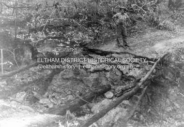
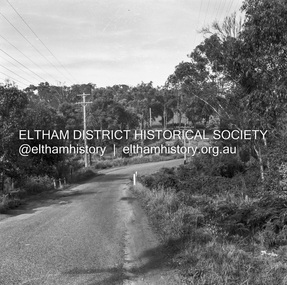 Eltham District Historical Society Inc
Negative - Photograph, J.A. McDonald, Heidelberg-Kinglake Road, 11 May 1961
Silvan Road Bridge Looking southwards before reconstruction View centreline to right of old structure 11 May 1961Record of various Shire of Eltham infrastructure works undertaken during the period of 1952-1962 involving bridge and road reconstruction projects, sometimes with Eltham Shire Council Project Reference numbers quoted. It was during this period that a number of significant improvements were made to roads and new bridges constructed within the shire that remain in place as of present day (2022). In many situations, the photos provide a tangible visible record of infrastructure that existed throughout the early days of the Shire. The album was put together by or under the direction of the Shire Engineer, J.A. McDonald.1961-05-11, heidelberg-kinglake road, infrastructure, reconstruction works, road construction, shire of eltham, silvan road bridge