Showing 1579 items
matching building development
-
 Eltham District Historical Society Inc
Photograph, Liz Pidgeon, Heritage Excursion; The 1901 Eltham Railway Walk, 3 May 2014, 3 May 2014
... and other buildings but development at that time was rather sparse... and other buildings but development at that time was rather sparse ...Newsletter No. 216, May 2014 May Excursion – The 1901 Eltham Railway Walk The railway from Heidelberg to Eltham was opened in 1902. Over the previous year railway construction cut a curving swathe through Josiah Holloway’s 1851 Little Eltham subdivision. The survey plans for the railway show the owners and occupiers of land within Little Eltham affected by the railway alignment and for some distance each side. The plans show houses and other buildings but development at that time was rather sparse. Copies of these plans from the State Library of Victoria collection have been provided to the Society by Alan Sheehan. For our walk on 3rd May we intend to follow the railway from the Eltham Station to Ryans Road, which was the boundary of the adjoining Montmorency Farm. The return will be by way of nearby streets. Along the way we will discuss the details shown on the railway plans as well as more recent railway documents and photographs. At the conclusion and if time permits we can inspect the historical display at the Eltham Station. The walk is about 3 km in length and will take about 2.5 hours. It will start at 2 pm at the Eltham Railway Station car park (east/Main Road side) (Melway Ref. 21 J5).Born Digitalheritage excursion, activities, eltham district historical society, eltham railway station, eltham library, trestle bridge -
 Eltham District Historical Society Inc
Photograph, Liz Pidgeon, Heritage Excursion; The 1901 Eltham Railway Walk, 3 May 2014, 3 May 2014
... and other buildings but development at that time was rather sparse... and other buildings but development at that time was rather sparse ...Football match at Eltham Central Park between Eltham and Heidelberg Newsletter No. 216, May 2014 May Excursion – The 1901 Eltham Railway Walk The railway from Heidelberg to Eltham was opened in 1902. Over the previous year railway construction cut a curving swathe through Josiah Holloway’s 1851 Little Eltham subdivision. The survey plans for the railway show the owners and occupiers of land within Little Eltham affected by the railway alignment and for some distance each side. The plans show houses and other buildings but development at that time was rather sparse. Copies of these plans from the State Library of Victoria collection have been provided to the Society by Alan Sheehan. For our walk on 3rd May we intend to follow the railway from the Eltham Station to Ryans Road, which was the boundary of the adjoining Montmorency Farm. The return will be by way of nearby streets. Along the way we will discuss the details shown on the railway plans as well as more recent railway documents and photographs. At the conclusion and if time permits we can inspect the historical display at the Eltham Station. The walk is about 3 km in length and will take about 2.5 hours. It will start at 2 pm at the Eltham Railway Station car park (east/Main Road side) (Melway Ref. 21 J5).Born Digitalheritage excursion, activities, eltham district historical society, eltham railway station, eltham library, trestle bridge, eltham central park, football -
 Eltham District Historical Society Inc
Photograph, Liz Pidgeon, Heritage Excursion; The 1901 Eltham Railway Walk, 3 May 2014, 3 May 2014
... and other buildings but development at that time was rather sparse... and other buildings but development at that time was rather sparse ...EDHS Member Doug Orford stands by a yarn bombing installation. ewsletter No. 216, May 2014 May Excursion – The 1901 Eltham Railway Walk The railway from Heidelberg to Eltham was opened in 1902. Over the previous year railway construction cut a curving swathe through Josiah Holloway’s 1851 Little Eltham subdivision. The survey plans for the railway show the owners and occupiers of land within Little Eltham affected by the railway alignment and for some distance each side. The plans show houses and other buildings but development at that time was rather sparse. Copies of these plans from the State Library of Victoria collection have been provided to the Society by Alan Sheehan. For our walk on 3rd May we intend to follow the railway from the Eltham Station to Ryans Road, which was the boundary of the adjoining Montmorency Farm. The return will be by way of nearby streets. Along the way we will discuss the details shown on the railway plans as well as more recent railway documents and photographs. At the conclusion and if time permits we can inspect the historical display at the Eltham Station. The walk is about 3 km in length and will take about 2.5 hours. It will start at 2 pm at the Eltham Railway Station car park (east/Main Road side) (Melway Ref. 21 J5).Born Digitalheritage excursion, activities, eltham district historical society, eltham railway station, eltham library, trestle bridge, yarn bombing, doug orford -
 Melbourne Tram Museum
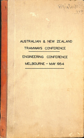
Document - Report, Melbourne & Metropolitan Tramways Board (MMTB), "Australian & New Zealand Tramways Conference - Engineering Conference Melbourne - May 1954", Jul. 1954
... , buses, new developments, inspections, buildings and Perway... Engineers. Programme looked at both trams, buses, new developments ...Report - Foolscap - approx. 144 pages, bound with sewn sections in a volume with hard covers with red cloth spine, titled "Australian & New Zealand Tramways Conference - Engineering Conference Melbourne - May 1954". Has an index - see htd5643i2.pdf Conference - Monday 24/5/1954 to Friday 28/5/1954. Transcript of the conference, opened by Mr Risson. Had attendees from Adelaide, Brisbane, Hobart, Melbourne, Perth and Sydney. Lists the attendees, mainly the Chief Engineers. Programme looked at both trams, buses, new developments, inspections, buildings and Perway (track) and research.trams, tramways, conferences, mmtb, chief engineer, tramways, buses, trackwork, trolley wheels, bearings -
 Kew Historical Society Inc
Plan, Melbourne & Metropolitan Board of Works : Borough of Kew : Detail Plan No.1576, 1904
... Town, then City of Kew. The hand-coloured sections of buildings... (yellow), and public buildings (grey). Development in the 20th ...The Melbourne and Metropolitan Board of Works (MMBW) plans were produced from the 1890s to the 1950s. They were crucial to the design and development of Melbourne's sewerage and drainage system. The plans, at a scale of 40 feet to 1 inch (1:480), provide a detailed historical record of Melbourne streetscapes and environmental features. Each plan covers one or two street blocks (roughly six streets), showing details of buildings, including garden layouts and ownership boundaries, and features such as laneways, drains, bridges, parks, municipal boundaries and other prominent landmarks as they existed at the time each plan was produced. (Source: State Library of Victoria)This plan forms part of a large group of MMBW plans and maps that was donated to the Society by the Mr Poulter, City Engineer of the City of Kew in 1989. Within this collection, thirty-five hand-coloured plans, backed with linen, are of statewide significance as they include annotations that provide details of construction materials used in buildings in the first decade of the 20th century as well as additional information about land ownership and usage. The copies in the Public Record Office Victoria and the State Library of Victoria are monochrome versions which do not denote building materials so that the maps in this collection are invaluable and unique tools for researchers and heritage consultants. A number of the plans are not held in the collection of the State Library of Victoria so they have the additional attribute of rarity.Original survey plan, issued by the MMBW to a contractor with responsibility for constructing sewers in the area identified on the plan within the Borough of Kew. The plan was at some stage hand-coloured, possibly by the contractor, but more likely by officers working in the Engineering Department of the Borough and later Town, then City of Kew. The hand-coloured sections of buildings on the plan were used to denote masonry or brick constructions (pink), weatherboard constructions (yellow), and public buildings (grey). Development in the 20th century has irreparably altered that part of Kew represented in this plan. In the block bounded by Cotham Road, Charles Street, Wellington Street and Gellibrand; just one house standing in 1903 remains. This block included two of the most historic houses in Kew: ‘Ordsall’ (later ‘Southesk’) and ‘Madford’ (previously ‘Elm Lodge’). Ordsall was the home of the second chairman of Kew, John Halfey. It contained some of the most significant interior murals in Kew, created for Halfey by artists working for Cullen & Co. It was demolished in 1960 to make way for the Kew Civic Centre. Elm Lodge had been built for William Siddeley in ca. 1864. Arthur Septimus King purchased it in 1874. The lower paddocks of Madford were sold in 1905 by his wife to the Borough of Kew and, after landscaping by George and Thomas Pockett, opened as the Alexandra Gardens in 1908. Elm Lodge/Madford was in 1922 to become St. Anthony’s Home for Little Children before its subsequent demolition in the 1980s.melbourne and metropolitan board of works, detail plans, maps - borough of kew, mmbw 1576, cartography -
 Eltham District Historical Society Inc
Photograph - Digital Photograph, Marguerite Marshall, Former home of Alistair and Margot Knox, King Street, Eltham, 16 January 2006
... ahead of its time.2 He also contributed to building development... ahead of its time.2 He also contributed to building development ...Situated in King Street, Eltham, Alistair Knox built his home and office in 1962-1963 with mud-bricks made from the local soil and recycled materials blending the house with bush around it. Knox popularised the Eltham earth building movement, begun by Montsalvat founder, Justus Jorgensen. Alistair Knox (1912-1986) was also an Eltham Shire Councillor 1971-1975 and Shire President in 1975. Knox established the inaugural Eltham Community Festival in 1975. Covered under Heritage Overlay, Nillumbik Planning Scheme. Published: Nillumbik Now and Then / Marguerite Marshall 2008; photographs Alan King with Marguerite Marshall.; p145 Lack of money was a strong incentive for Alistair Knox to do what he did best when he built his house and office at King Street, Eltham in 1962-63. He used mud-bricks from local soil and recycled materials, characteristically blending the house with the bush around it. The result was a work of art. Knox popularised the Eltham earth building movement,1 begun by Montsalvat founder Justus Jörgensen. He was also an Eltham Shire Councillor from 1971 to 1975 and Shire President in 1975. For Knox mud-brick building was not just a building style, but a spiritual experience and a way of relating with nature. At 40 he rediscovered God and his building reflected his theological, political, philosophical and particularly environmental world view, which was far ahead of its time.2 He also contributed to building development in his use of concrete slab foundations when stumps and bearers were the norm. Knox was introduced to mud-brick construction in 1940 by Jörgensen, then shortly after, Knox joined the Navy. In 1946 Knox studied Building Practice and Theory at Melbourne Technical College (now RMIT University). There he befriended fellow student and artist Matcham Skipper who belonged to what was then called the Jörgensen Artists’ Colony. Knox decided to build an earth building in Eltham, partly because the post-war huge building demands resulted in expensive and scarce building materials. He asked artist Sonia Skipper for help who, with Matcham, had constructed mud-brick buildings at the Artists’ Colony. The simple rectangular low-lying house at King Street is framed by native plants and a 3.6 metres wide pergola surrounds the building. Wedded to the landscape, a door in every room at the perimeter, opens outside. The property also includes a forge, a small hut built by son Macgregor at 15, and a mud-brick tower for chickens. Building materials were foraged from a wide variety of sources. Some of the joinery material came from old whisky vats. When the Oregon of the highest quality ‘was put through the wood-working machines, it gave off a deep smell of whisky that made the whole atmosphere exotic and heady’.3 Amateur builders, including schoolboys from Knox’s Presbyterian Church, made some of the mud-bricks. But the building was finished with the professional help of Yorkshire builder, Eric Hirst. Inside, the light is subdued with the mud-brick, beamed timber ceilings and floors of slate, timber or orange-brown tiles. Skylights, with rich blue and red leadlighting, illuminate one entrance area and this feature is repeated as edging on the door. The centre of the house is like a covered courtyard, with rooms built around it. The central room, 11 metres x 7 metres, was built in the same proportions as Knox’s mud-bricks. Clerestory windows on four sides infuse the room with a soft light. A huge brick fireplace extends beyond one corner and opposite is a small one where timber can only be placed vertically. The slate for the floor was discarded from the Malthouse Brewery now used as a theatre in Southbank. In the middle is a large refectory table and benches that seat 18. Like much of the house, it is rugged, yet beautiful. Made of Western Australian Jarrah by Macgregor with a chain saw and an adze, it retains knot and nail holes. Each wall has an opening, 2.4 metres at the ends and 3.6 metres at the sides. Only one has doors and these concertina doors are made of the backs of old church pews. The main bedroom has an ensuite with a marble hand basin discarded from the Victorian Parliament building; and a dressing room, where two wardrobes of polished timber recovered from a tip are attached to the walls. Separate from the house is the strikingly original circular-shaped office made of bluestone sourced from the original Army campsite at Broadmeadows.This collection of almost 130 photos about places and people within the Shire of Nillumbik, an urban and rural municipality in Melbourne's north, contributes to an understanding of the history of the Shire. Published in 2008 immediately prior to the Black Saturday bushfires of February 7, 2009, it documents sites that were impacted, and in some cases destroyed by the fires. It includes photographs taken especially for the publication, creating a unique time capsule representing the Shire in the early 21st century. It remains the most recent comprehenesive publication devoted to the Shire's history connecting local residents to the past. nillumbik now and then (marshall-king) collection, alistair and margot knox house, alistair knox design, mudbrick construction, eltham, king street -
 Eltham District Historical Society Inc
Document, Prospectus: Kinloch Gardens, Eltham Victoria, 1998c
... . Building design and development will be under the control.... Building design and development will be under the control ...“Kinloch Gardens at Eltham, Victoria is planned as a comprehensively designed and cohesive residential environment.” “Only twelve innovatively designed houses ,will be situated within the established gardens and grounds of this historic Eltham estate. Building design and development will be under the control of the Kinloch Gardens design and construction team.” “Kinloch Gardens is situated on one of the highest points in Eltham and enjoys panoramic views in all directions.” “Kinloch Gardens lies hidden from the outside world behind high stone retaining walls, terraced embankments and extensive landscaping. The existing buildings, amongst the most significant of the Eltham / Montsalvat domestic building tradition are set in park like surrounds and enjoy panoramic views of the ranges to the north east and the city sky line to the west. New houses combined with sensitive landscaping will blend immediately into the established garden environment and will share the amenity and ambience of a very private and unique estate. The central theme of the landscape master plan is a garden reserve and a planted avenue terminating in a -small square.” “Houses vary in size from 120m2 (12.9 squares) to 210m2 (22.6 squares) (or larger) and include an extensive range of planning options. House types include: The Studio House The Tower House The Pergola House The Gallery House 'The Barn' is one of the existing buildings of Kinloch Gardens and is situated on the premium Lot 11.” Developer: Kinloch Pty Ltd. Project Managers: Creative Block Design Pty Ltd. Architects: Graeme Gunn and Ian Jelbart. Landscape Architect: Suzy Boyd. Builder: Vizarje Homes Pty Ltd. Surveyors and Engineers: Miller Merrigan.Digital file only; created from scan undertaken by EDHSarthur street, creative block design pty ltd., eltham, graeme gunn, houses, ian jelbart, kinloch gardens, kinloch pty ltd, miller merrigan, real estate, suzy boyd, vizarje homes pty ltd. -
 Eltham District Historical Society Inc
Document, Kinloch Gardens Property Album; Elders Real Estate sales material, 1998
... . Building design and development will be under the control.... Building design and development will be under the control ...“Kinloch Gardens at Eltham, Victoria is planned as a comprehensively designed and cohesive residential environment.” “Only twelve innovatively designed houses ,will be situated within the established gardens and grounds of this historic Eltham estate. Building design and development will be under the control of the Kinloch Gardens design and construction team.” “Kinloch Gardens is situated on one of the highest points in Eltham and enjoys panoramic views in all directions.” “Kinloch Gardens lies hidden from the outside world behind high stone retaining walls, terraced embankments and extensive landscaping. The existing buildings, amongst the most significant of the Eltham / Montsalvat domestic building tradition are set in park like surrounds and enjoy panoramic views of the ranges to the north east and the city sky line to the west. New houses combined with sensitive landscaping will blend immediately into the established garden environment and will share the amenity and ambience of a very private and unique estate. The central theme of the landscape master plan is a garden reserve and a planted avenue terminating in a -small square.” “Houses vary in size from 120m2 (12.9 squares) to 210m2 (22.6 squares) (or larger) and include an extensive range of planning options. House types include: The Studio House The Tower House The Pergola House The Gallery House 'The Barn' is one of the existing buildings of Kinloch Gardens and is situated on the premium Lot 11.” Developer: Kinloch Pty Ltd. Project Managers: Creative Block Design Pty Ltd. Architects: Graeme Gunn and Ian Jelbart. Landscape Architect: Suzy Boyd. Builder: Vizarje Homes Pty Ltd. Surveyors and Engineers: Miller Merrigan.Digital file only; created from scan undertaken by EDHSarthur street, elders real estate, eltham, kinloch gardens, real estate agent, the barn -
 Federation University Historical Collection
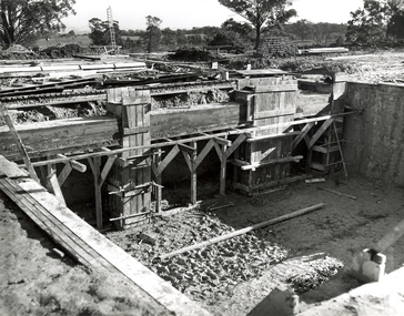
Photograph, N.l. Harvey & Son, Mount Helen Campus, 1968, 1969
... development. .1) Aerial view of foundation work, from west, towards... view. First columns of E building. .13) Mt Helen development ...The Federation University campus at Mount Helen was first used by students in 1970.Seven photographs of the Mt Helen Campus Stage one development. .1) Aerial view of foundation work, from west, towards Green Hill .2) Aerial View from South. Earthworks and foundations .3) Aerial View from south west. Earthworks, general view .4) Aerial View from above the South West corner of E building. .5) Aerial View from North East. Gear Avenue in background .6) Aerial View from North West. Earthworks extend from Gear Avenue .7) Ground level view. First columns of E building. .13) Mt Helen development Stage One, Engineering Diploma Buildings. This image shows the wall beam and pier construction to the East Wall of the Fluid Mechanics Laboratory adjacent to the pump chamber, 17 June 1968. .18) Flume Pit and Pump Chamber, 15 July 1968. .28) East Wing Pit Looking North, 26 August 1968 .40) Construction as of 04 November 1968federation university, federation university australia, feduni, university of ballarat, ballarat college of advanced education, ballarat institute of advanced education, building, earthworks, foundation, early development, soil testing laboratory -
 Eltham District Historical Society Inc
Document - Property Binder, 616 Main Road, Eltham; Plum Cottage
... in an important phase of Eltham’s earth building development, using his... in an important phase of Eltham’s earth building development, using his ...Plum Cottage is covered by Heritage Overelay HO256 in the Nillumbuk Planning Scheme This two-lot land holding was created as a subdivision and sold to Charles Stuart McNeil by May 1955. Sometime in the period 1955-1960, the builder-designer, John Harcourt had created a pise house on the site, straddling the two subdivision lots. The designer, John M. Harcourt was a pioneer builder in pise-de-terre and mudbrick in the Eltham Shire, Eltham being synonymous with alternative lifestyles and building practises until the onset of suburbia in the late 20th and early 21st centuries. This hipped-roof house is set high above Main Road on a V-shape plan characteristic of the Arts & Crafts style, with rammed earth or pise walls, timber joinery and a cement tiled roof. The V shape plan was used by important English and Eltham Arts & Crafts designers. The use of natural materials such as stone and timber construction is an essential part of the Arts & Crafts style and Harcourt’s work. So too is the application of the style on both the exterior and interior of the house as a holistic concept. The house adjoins the Lim Joon adobe house built and designed by Alistair Knox in the same era (HO119), thus forming a distinctive pair, both using an uncommon plan form. This house was identified in the Shire of Shire of Eltham Heritage 1992 as contributory to the Eltham Gateway Conservation Area, then proposed as an urban conservation area (now Heritage Overlay Area). Land Ownership Emily Jane Smith of 12 Woodside Street Fitzroy owned Crown Allotments 1 & 2 Sections 14, 27 by August 1918, selling to William Henry Smith of 12 Woodside Street, Nth Fitzroy May 1921. (John) James Isherwood of Main Road, Eltham owned the property by 1928 (the year of his death) with the beneficiary of his estate and next owner of this site being his widow, Minnie Maria Isherwood of Cemetery Road, Eltham. His holding in Main Road included parts of what was described in rate records as allotments1 & 2 Section E6. In the late 1930s, early 1940s her son Alfred John Isherwood was also rated for the land around this site, with the rated nett annual value varying between £2 and £5. Alfred Isherwood also lived at Main Road, Eltham with his wife Ellen: her early death at the age of 24 was reported in the Argus of 1923. Part of the Isherwood land was divided off and sold to Charles Stuart McNeil by May1955. Sometime in the period 1955-1960, the builder-designer, John Harcourt had created a pise house on the site, straddling the two subdivision lots. The house is visible on an aerial photograph from 1960s. Reputedly the house was called Plum Cottage and erected for Harcourt’s mother-in-law. A garage was added in 1959. Charles McNeil died in1971 aged 87: he was the son of Don McNeil and Margaret Arkell. Available rate records from the construction era start in the of the 1970s (1972-3) and list Mr H.C. & M/S A.V. Charity at 616 Main Road Eltham of this property with a nett annual value of $740. More recent valuer's data describes the property as lots 1 & 2 LP25668, located in the Central Riding of Eltham Shire, owned by Ann Valerie Charity and later, in 1990, by the Chincarini family. Building Description This hipped roof 11 .5 square house is set high above Main Road on a characteristic-shape plan and has rammed earth or pise walls, timber joinery and a cement tiled roof. The V-shape plan was used by Important designers such as C.F.A. Voysey (UK) who interpreted medieval domestic architecture as part of the Arts & Crafts style of the late 19th and early 20th centuries. The pise walls are covered with a textured render while the cement roofing tiles are also seen in the Harcourt Hill examples. Reputedly the ceiling joists are of a deep section and span long lengths with no need for hanging beams in the roof space. The ceilings are low and panelled in main rooms with apparently Caneite soft board infill panels between the exposed ceiling beams. These are painted white but may have been stained at one time. The focus of the house is the large living area with its vast random stone fireplace. Significance Plum Cottage is significant to the locality of Eltham because: Historically: • Plum Cottage is closely associated with the important historical theme of earth construction evident in Eltham and elsewhere in the Shire since theear1y Arts & Crafts inspired creations at Penleigh Boyd's The Robins (1912, HO101) and those at Montsalvat (1934-, HO82) but more prominent from the Second War period when earth building in Eltham was promoted in national periodicals as an alternative building method that avoided the building materials shortages of that era; • The choice of the earth building technique also expresses the theme of refuge or alternative living, synonymous with Eltham in the early to mid 20th century; • as a good example of domestic architecture from John Harcourt who was the first major post Second War figure in an important phase of Eltham’s earth building development, using his characteristic Old English or Arts& Crafts style that relies in this case on the pise wall construction, pitched roof forms, exposed ceiling joists, half timbering, random stonework, and panelled internal wall finishes. Architecturally: • Plum Cottage's pise wall construction is uncommon among the early earth-walled structures in the Shire, that are mainly of adobe or mud brick, and as a building material is uncommon among the Shire’s suburban dwellings generally which are clad typically with either fired clay bricks or timber boarding. Aesthetically: • Plum Cottage is a good and well preserved example of a modern Old English or Arts & Crafts style earth-walled building in the Shire • For the proximity of the significant Lim Joon adobe house designed by Alistair Knox adjoining to the north, providing a distinctive earth wall house pair, with uncommon plan forms. Reference Heritage Assessment of Plum Cottage, 616 Main Road, Eltham; Graeme Butler & Associates 2010main road, eltham, property, houses, (john) james isherwood, alfred john isherwood, ann valerie charity, arts and crafts style, charles stuart mcneil, chincarini family, eltham gateway zone, emily jane smith, h.c. charity, heritage assessment, john harcourt, john m. harcourt, lim joon house, main road eltham, minnie maria isherwood, pise construction, plum cottage -
 The Beechworth Burke Museum
Photograph - Photographs, E. Yellard, c. 1950's
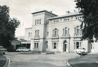
Two rectangular black and white photographs of the Beechworth Mental Hospital (Mayday Hills) administrative building showing the left and right hand sides of the exterior building with three cars parked in driveway turning circle in the foreground taken in the 1950's by E. Yellard. Mayday Hills Hospital, originally known as the Beechworth Lunatic Asylum was constructed between 1864-67 designed by The Public Works Department. The hospital is made up of a number of buildings, landscaping, ha-ha, workshops, laundry, administrative facilities and farmland, it was constructed in 'Italianate' style by a team of up to two hundred and fifty workers (Woods p. 122). The asylum was established in response to the need for the regional shire to locally care for those particularly affected by their time working the Ovens goldfield during the Indigo Shire gold rush era where poor living conditions and isolation were significantly affecting the welfare of a great many people through poverty and lack of resources. The gaol and orphan labour systems were not able to effectively support to give housing, rehabilitation and ongoing care for the mentally ill, and transporting to Melbourne by waggon was a time consuming and counter-productive solution when the metro facilities were already overcrowded. According to Woods (A Titan's Field p. 122), between 1901 and 1911 a large percentage (thirty five percent in 1901 and twenty four in 1911) of the Beechworth population were either patients or inmates of Beechworth institutions, Mayday Hills accounted for some six hundred and seventy four patients in 1901, Beechworth's Mayday Hills was chosen as the site of Victoria's newest asylum, at the time, due to the landscape and altitude. The hilltop atmosphere and the native fauna, it was argued, would assist in the cure of the patients kept at the hospital (Wood 1985, 122). The positioning of the hospital had a beneficial effect on the rural town and the large volume of people living at the hospital and contributing to this population growth is counted as reason for the survival of Beechworth as a regional township. According to the Victorian Heritage database, during the period 1921-1950 Mayday Hills underwent some modernisation by Public Works Department architect Percy Everett which included a nurses' hostel and new ward which were further developed and continued to function as a mental hospital up until 1995 when it was sold to LaTrobe university. The building and grounds are listed on the Victorian Heritage Register under criterion A, B, D, E and F.These photographs give a good indication of the ongoing use of Mayday Hills from its original establishment in the 1860's through to almost one hundred years later when these photographs were taken. The clarity of the images combined with the style and make of the cars in the foreground give a good indication of the time period and show the continued use and need for the facility over the years. Through images of building facades such as these, we might gain fuller understanding of the structural and aesthetic characteristics to be used in any future development or restorative work.2 x black and white rectangular photographs [copies] printed on Ilford photographic paper8688.1 reverse: Beechworth / Mental / Hospital / 80% 19cm / 12 cm / 80% / 728 / New / Print / BMM / 8688.1 / E. / Yellard / [Stamped : ILFORD] 8688.2 reverse: Beechworth / Mental / Hospital / E. / Yellard / BMM / 8688.1 / [Stamped : ILFORD]administrative building, black and white photographs, beechworth, mental hospital, beechworth mental hospital, mayday hills, cars, 1950, e. yellard, the public works department, public works department, hospital, mayday hills hospital, beechworth lunatic asylum, lunatic asylum, asylum, ovens goldfield, indigo shire, indigo shire gold rush -
 The Beechworth Burke Museum
Photograph, Circa 1858
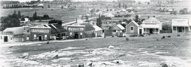
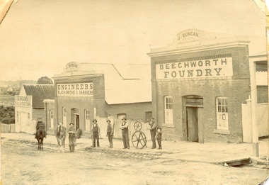
Taken around 1858, depicting a row of five business buildings on a rocky, sloping hillside at New Town, with a view across to residences and open land. Businesses included, Joseph E. Bishop, Coach Builders; Straughair Duncan, Engineers, Blacksmiths & Farriers; Straughair Duncan, Beechworth Foundry; Wholesale & Retail Est. 1855, Mackenzie Family Store ; and T. Pratten, Grocer. Eleven men may be seen outside the Foundry building. The Mental Hospital can be seen in the background. Mark Straughair and John Duncan, established the Beechworth Foundry, Newtown in 1858 and went on to build an important industry, employing around sixteen men, after acquiring Alexander Roger's New Ford Street Foundry in the late 1860s. Making and repairing mostly mining and agricultural machinery for the Ovens District and a Beechworth brewery, the business continued to function after Straughair's death in 1882, up until the death of Duncan in 1896, when the business folded. This photograph is historically significant because it shows the development of the businesses in Beechworth from the early establishment of the town.Black and white rectangular photograph printed on photographic paperReverse: [Agfa wordmarks: diamond-shaped watermarks for Agfa photographic paper] 1997.2642/ refer to/ 1997 2650/ 3056joseph e. bishop, mark straughair, john duncan, mackenzie family store, beechworth foundry, coach, coach builder, engineer, blacksmith, farrier, t. pratten, beechworth grocers, grocer, new town, newtown beechworth, newtown, foundry, 1858, local business, new ford street foundry, alexander rogers, victorian agricultural history, mining machinery, beechworth brewery, ovens district, mayday hills mental asylum, beechworth mental hospital, beechworth mental asylum, mental hospital, mental -
 The Beechworth Burke Museum
Photograph, c1900
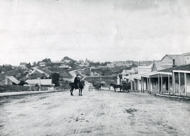
Believed to have been taken sometime between 1858 and 1908, featuring a man with moustache, dressed in hat and long riding coat, seated on a bob-tailed horse, is stopped in the middle of a wide dirt road in Beechworth. He is outside a row of businesses, including R.McKenzie & Sons Grain Store and Mackenzie Family Store (Wholesale & Retail Est. 1855), along a sloping hill. Behind the main rider are a parked horse and laden two-wheeled cart backed up directly outside the grain store's verandah, and another man is driving a horse and four-wheeled wagon forward towards them. At the bottom of the hill is a bridge (Newtown Bridge) with forked road on the far side, leading to a number of houses on both sides of another hill. This image is looking down Bridge Street, Newtown, Beechworth and across to Ford Street (left) and High Street (right). Road-making was a focus of town development during the 1850s, and the wide streets were created on the instructions of the surveyor-general to be between sixty-six and ninety-nine feet wide to give the town a pleasing aspect.This photograph is important in showing the development and expansion of the various businesses and buildings in Bridge Street of Newtown, Beechworth. Black and white rectangular photograph printed on paperReverse: 6980/ PH 118/ 1998.00059/beechworth, new town, newtown, newtown beechworth, local business, mackenzie family store, mackenzie's family store, mackenzie, grain store, bridge, ford steet, high street, colonial australia, australian gold rushes, mining technology, beechworth historic district, indigo gold trail, migration, indigo shire, mckenzie and sons grainstore, mckenzie family store, mckenzie, newtown bridge -
 The Beechworth Burke Museum
Photograph, c1900
The Beechworth Foundry was vital to the industry of the town and surrounding district in the early years of the town’s development. Originally opened as the New Ford Street Foundry by A. Roger in 1858, J Duncan and M Straughair amalgamated and established the Beechworth Foundry in 1867. The business was extensive and operated out of many buildings, each with their own specialisation. All of the buildings pictured in this image are part of the larger Beechworth Foundry. In the late 1860s it employed 16 men. The foundry was fundamental to the running of the town and surrounding district, as it manufactured all manner of items, including tools and machinery for the mining and agricultural industries. The foundry business collapsed in 1896 after the death of it’s founder, John Duncan, the same year (Straughair had died in 1882). The foundry was reopened by W H Phillips in 1905 and taken over by H Delora in 1906 This image is significant as it shows some of the many buildings of the Beechworth Foundry, which was a fundamental business to the running of the town and surrounding district, and supplied many of the tools and machines required for the mining and agricultural industries, as well as other aspects of life between the 1850s and early 1900sSepia rectangular photograph printed on paper. It has rough, torn-looking edgesReverse 97.2321 / BMM A03115duncan, john duncan, j duncan, m straughair, straughair, foundry, beechworth foundry, industry, factory, newtown, new ford street foundry, a roger, roger, w h phillips, phillips, w phillips, h delora, delora, metalwork, farming and agriculture, tools, mining, workmen -
 The Beechworth Burke Museum
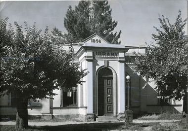
Photograph, Caldwell, c1950/60s
A photo of the original Burke Library building between two medium sized trees, a lamp post sits between them and a large tree is behind the building. This photo was taken c1950/60s.This photo is of both historical and social significance to the people and community of Beechworth because it shows the development of the Burke Museum from what it was in this picture, to what can be seen today. It also shows the Burke Museum's prominent architecture marking it as a particular point of interest within Beechworth. Along with the aspects of the building that the Burke museum is known for today, such as the façade and the central lamp post, all of which are significant to the town of Beechworth and its people.Black and white rectangular photograph printed on photographic paper.Obverse: 1856 / Library Reverse: Beechworth Library / 33 1/3% / Caldwell / 19 eu (illegible) / 11 eu (illegible) / 729 / 3 1/6 / BMM 8691 / S / T / E / T (Scribbles and arrows across the page)burke museum, beechworth, 1950s, architecture, landscaping, development