Showing 75 items
matching hume highway
-
 Eltham District Historical Society Inc
Photograph, Hume and Hovell Monument, Yarck (3.12.1824), Spring Excursion, Hume and Hovell's 1824 expedition (Part 2), 26 October 1997, 26/10/1997
... to the recent amalgamations). We headed towards the Hume Highway via... to the recent amalgamations). We headed towards the Hume Highway via ...[article by Diana Bassett-Smith in EDHS Newsletter No. 117, November 1997:] MONUMENT HUNTING THE HUME AND HOVELL WAY - Sunday October 26 1997 dawned bright and very warm. Some twenty-five members, complete with picnic baskets, met outside the Eltham Library awaiting the Cobb and Co. large coach which would be taking us on the second leg of our travels along the route of the early explorers Hume and Hovell. Stephen West was our very good driver for the day. He would be guided around the circuitous route by Russell Yeoman who had made a detailed study, not only of the intended route, but of the story of these two explorers. During the trip Russell regaled us with poetry, quotations from the Journals and the History of the Shire of Seymour, "The New Crossing Place" by Martindale, 1982, (now Mitchell Shire due to the recent amalgamations). We headed towards the Hume Highway via Greensborough and Cooper Street and proceeded north to our first stop, noting on the way Monument Hill in the distance which is near Kilmore and, according to Russell, well worth the effort to visit as the view across the valley is magnificent. Past Sunday Creek Valley, Mt Piper and Mt Disappointment, all traversed and noted and named by them. We passed through Tallarook, then onto Seymour where we took photos of the monument telling us that Hume and Hovell had passed through on the 28th of October 1824. We also deviated down Hume and Hovell Road viewing deer and emu farming and the Bellbourie property now a sanctuary. Leaving Seymour behind we travelled up the Avenel Road to the Avenel monument, pyramidal in design of four reducing square blocks with a sharply pointed peak, erected in 1924 in memory of the 1824 exploration. The day was warming up and the countryside showing the dryness of the current drought. A parallel note had been made in their journal too of 1824 of the drought appearance of the country they were traversing. At Seven Creeks, Euroa we stopped for some minutes to check the monument placed 20th November 1924 to commemorate their passage on the 29th December 1824. More photos. Russell had pointed out the abrupt termination of the distant ranges which is noted in their journal. The next monument is beside the road at the entrance to Honey Suckle Creek Caravan Park, Violet Town. The squarish shaped monument some eight feet high is topped with a simple steel cross, and was to mark the date of 28th December 1824 and built for the 20th November 1924. By now it was 12.20 and nearly lunchtime as we drove along the Warranbayne Road to Roach's Road, monument hunting without success. Though there is a large, what appears to be an old timber sign which was hard to read, maybe this was the lost monument. In many of the paddocks hay had been cut and baled or was being cut, what a contrast to the rugged country they had passed through which was smoky from the fires of the natives burning off. By 1.00 pm we were at Benalla and pulled up beside the park where abundant beds of roses filled the air with their scent and the smell of barbecued food twitched the nostrils whilst the cheerful sounds of other picnickers could be heard throughout the park. We left the bus and collected up our picnics, dispersed to the various tables and enjoyed the shade from the various European trees. 2.00 pm and we were on the road again driving along the Benalla, Mansfield, Yea road. The Swanpool monument states that they passed four miles south and returned three miles north. Then we stopped at the Barjarg monument which notes that they camped near this spot. It is again a pyramidal monument and this time topped with a steel arrow indicating their route of the 29th November 1824. Half an hour later we came to another monument, again with a steel arrow marker on top and the plaque dated the 2nd of 12th 1824. Erected on the 12th of 12th 1924. "They blazed the way that we might inherit the land." Another square based and needle topped monument appeared at Yarck near Yea and this plaque records the date of 3 December 1824. Near McGuigans Road Russell related that the expedition had lost a dog but it had found them next day, the dog was apparently torn by a kangaroo. A short while later Russell reminded us here of the problems they encountered in crossing the Goulburn River near Molesworth where banks were high, water deep and wide. "Good coat of grass but quite dry due to drought". At Yea we stopped for afternoon tea and raided the last of our picnics and looked at the monument to their journey of 1824, situated at a corner of the gardens near the bowling green. No photo – we were out of film. We returned home via Kinglake West and Whittlesea past the Yan Yean Reservoir, not full. 5.00 pm back at Eltham we emptied out of the bus and everyone, including Joan Cole, collected their things, Joan also had the major souvenir of the day, a large carp she had picked up from the river bank, her cat was in for a great feast. The day was made so interesting by the informed commentary which Russell provided. His background knowledge of the route and nature of the journey could only have come from many hours of reading and driving the area. Thank you to Russell and to everyone who made the day so informative and pleasurable. Colour photographactivities, hume and hovell, monument, yarck -
 Greensborough Historical Society
Map, Australia. Department of Minerals and Energy, Melbourne, topographic map, 1970_
... . A pre-metric map, shows the Hume Highway travelling through ...A topographic map of Victoria with Melbourne as the centre. Provisional edition showing contours in feet. International map of the world [scale] 1:1,000,000. Prepared by the Department of Minerals and Energy, Canberra in 1970.A pre-metric map, shows the Hume Highway travelling through towns such as Seymour and Benalla, now by-passed by the Hume Freeway.Map, printed in colour on one side.victoria - maps -
 Hume City Civic Collection
Photograph
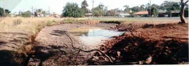
A photo of Old Calder Highway in Diggers Rest with houses on one side and a manmade waterhole on the other side beside the railway line. The railway crossing can be seen in the background next to the railway station.A colour photograph of a waterhole on the side of the road and beside a railway line. It is unmounted.old calder highway, diggers rest, diggers rest railway station, railways, george evans collection -
 Hume City Civic Collection
Photograph
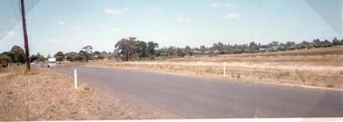
The old Calder Highway before the construction of the duplication of the Calder Highway between the Railway crossing and Plumpton Road.A coloured panoramic view of the old Caler Highway at Diggers Rest. It is unmounted.old calder highway, diggers rest, plumpton road, railways, george evans collection -
 Hume City Civic Collection
Photograph
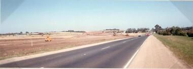
This photograph is of the duplication of the Calder Highway at Diggers Rest in the vicinity of Plumpton Road.A coloured panoramic view of the construction of the duplication of the Calder Highway in the vicinity of Plumpton Road. It is unmounted.calder highway, diggers rest, highway duplication, road construction and maintenance, plumpton road, george evans collection -
 Hume City Civic Collection
Photograph, c 1993
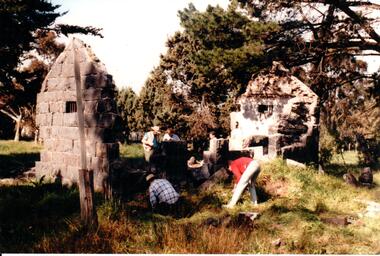
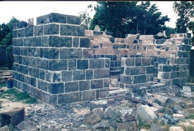
Aitkens Gap Police Lock up was originally constructed at The Gap which was south of the junction of Gap Road (Sunbury Road) and Calder Highway (Victoria St/Mt. Alexander Road). It was part of a police complex which was a changeover station for the gaol escort. The goal was relocated and rebuilt in the police station grounds in Sunbury in 1993.A coloured photograph of five men working on the removal of Aitkens Gap Gaol from its original site. Two end walls of the gaol are standing and the work is being done on the front and back of the building. Conifers and cypress trees are growing around the site.peter free, aitkens gap gaol, police historical association, sunbury police station, george evans collection -
 Hume City Civic Collection
Photograph, 1993
The Aitkens Gap Gaol was removed from its original site at Gap Village on the Calder Highway and relocated in front of the Sunbury Police Station in 1993.A coloured photograph of the resiting and rebuilding of the Aitken Gap Gaol outside the Police Station in Sunbury. The two end walls have been constructed as far as the windows and work has commenced on the front and back walls. Some stones are scattered around the site.peter free, aitkens gap gaol, sunbury police station, police historical association, george evans collection -
 Hume City Civic Collection
Photograph
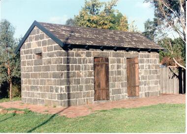
The Aitken Gap Gaol was originally constructed at the Gap Settlement on the Calder Highway in 1857 for the gold escorts. It was relocated to its present site outside the Sunbury Police Station in Macedon Street between 1989 and 1991.A coloured photograph of the relocated Aitken Gap Gaol. It has bluestone walls and a moss covered slate roof. with 2 solid stained wooden doors and blue painted wooden trims. A small cell window is on the side of the building and a paved brick area surrounds the gaol.aitken gap gaol, gap village, sunbury police station, george evans collection -
 Hume City Civic Collection
Photograph, early 1990s
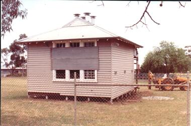
The small one roomed school is closed at the site along the Calder Highway and was relocated to the new school building in Plumpton Road at Diggers Rest. The former school building became the club rooms for the Diggers Rest Bowling Club when the new school opened in the late 1980s.A coloured photograph of the former Diggers Rest Primary School. The small one roomed weatherboard building with a corrugated iron roof has sheets of iron across the windows. The building is being prepared for relocation. A post hole digger is behind the building.diggers rest primary school, education department, diggers rest bowling club, george evans collection -
 Hume City Civic Collection
Photograph, 1990s
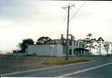
The fire damaged building is the former Diggers Rest Hotel which was ruined by fire in the 1990s. It was the last standing and operating hotel along the Calder Highway between the towns of Keilor and Gisborne. A coloured photograph of a fire gutted building along a roadside with gum trees in the background. -
 Hume City Civic Collection
Photograph, 1990s
The building which has been damaged by fire is the former Diggers Rest Hotel which was the only surviving hotel along the Calder Highway between the towns of Keilor and Gisborne a distance of approx. 32kms A coloured photograph of a grey rendered building, along a roadside, which has been damaged by fire with a temporary fence surrounding the building. diggers rest, hotels -
 Hume City Civic Collection
Photograph, Aitkens Gap Police Barracks, c1922
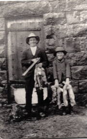
Frank Millett and his nephew Hopper Cahill are the two people standing by the building after spending the day shooting rabbits in 1922. They are standing in front of the Aitkens Gap Police Barracks. In the 1860s the gaol and stables were sold to George Millett and added to the Millett property. The Barracks and the new farm homestead were built by Mick Morrison. The Bald Hill Hotel at Aitkens Gap on the Bendigo Road (Calder Highway) was guilt by George Millett in 1854 and functioned until the gold began to run out after the Victorian Gold Rush of the 1850s. The Millett family continued to farm until 1967. The family also and operated hotels in the local area. A black and white photograph backed onto a white board of a man and a child holding some dead rabbits and standing in front of the doorway of a bluestone building. frank millett, george millett, aitkens gap gaol, hopper cahill -
 Hume City Civic Collection
Photograph, Schlossberg Vineyard, 1909
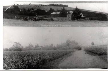
Schlossberg Vineyard was situated along Vineyard Road in Sunbury, between Winilba and the Calder Highway. It was established by Felix Frederick Bubeck, who arrived in Australia from Rotenberg (near Stuggart) in the 1860. In 1866 he acquired 60 acres of land on Bald Hill and established the vineyard. In 1880, claret produced on the property received an honourable mention when it was exhibited in Bordeaux, France,From the mid 1850s a number of vineyards were established on the hillsides overlooking Vineyard Road. The east facing outlook that captured the morning sun was ideal for growing grapevines. Other vineyards were also established in the area at the same time.A black and white copy of a postcard of two photographs mounted on the one card with the original handwritten message photocopied on the back. To my dear brother & sister with love and good wishes for a Merry Xmas & a prosperous 1909. Thanks for the paper Your loving sister Marie. You will think it a good photo You will see the trees have grown almost hiding the house. Mr. A Senling, Cheetham St. Kalgoorlie Sth. WAfelix frederick bubeck, schlossberg vineyard, bald hill, vineyards -
 Falls Creek Historical Society
Photograph - Bernhardt Plohberger and Felix Soratroi near Falls Creek Ski School
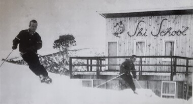
... , highway work on the Hume and Sugarloaf Dam in Victoria. Bernie..., highway work on the Hume and Sugarloaf Dam in Victoria. Bernie ...Bernard Plohberger was one of the early ski instructors at Falls Creek. He was born in Austria on 14 January 1930. He was a ski instructor before he left Austria in 1955. He spent the winter of 1956 working as a ski instructor and during the summer Bernie worked as a chainman for the SEC Surveyor. He built the Ski School at Falls Creek in 1957 as well as the Frying Pan Inn. In 1960 the Frying Pan Inn was taken over by Bill Bridgford who had helped to finance its construction. Bernie married his wife Trudi in 1958 and their son Gerhard was born at the ski school in 1959, the first child born at Falls Creek. Both Trudi and Bernie worked for Bob Hymans for a period at Grand Coeur Chalet. After leaving Falls Creek, Bernie and Trudi moved to Canberra where Bernie took work on civil engineering projects such as the coal loader in Wollongong, the Vietnam memorial in Canberra, highway work on the Hume and Sugarloaf Dam in Victoria. Bernie Plohberger died on 18 May 2020. Felix Soratroi was also an Austrian Ski Instructor who was encouraged by Bernie to move to Falls Creek and work at the Ski School.This item is significant because it depicts early Ski Instructors at Falls Creek Ski School.A black and white image of two skiers near the Falls Creek Ski School.bernard plohberger, frying pan inn, falls creek ski school, felix soratroi -
 Wodonga & District Historical Society Inc
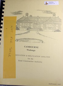
Booklet - Cambourne Wodonga : Conservation & Relocation Analysis for the Road Construction Authority, John & Thurley O'Conner, 1987
... and upgrade of the Hume Highway. Cambourne Wodonga : Conservation ...Research paper into the viability of relocating Cambourne Homestead in 2006 in order to make way for the widening and upgrade of the Hume Highway.non-fictionResearch paper into the viability of relocating Cambourne Homestead in 2006 in order to make way for the widening and upgrade of the Hume Highway. cambourne homestead wodonga, heritage building wodonga, carkeek family, potter family, building relocation