Showing 191 items
matching hustler's reef
-
 Bendigo Historical Society Inc.
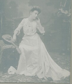
Photograph - ADA FARMER PHOTOGRAPH
... William Joseph Farmer formerly manager of the Hustlers Reef No 1... of the Hustlers Reef No 1 mine Photograph ADA FARMER PHOTOGRAPH ...Black and White photo of Miss Ada Farmer as a young woman wearing an Edwardian style dress, sitting in a large carved chair with a lute resting on a table, Miss Farmer was the daughter of Mr William Joseph Farmer formerly manager of the Hustlers Reef No 1 mineperson, individual, personal portrait, miss ada farmer, miss farmer, ada farmer -
 Bendigo Historical Society Inc.
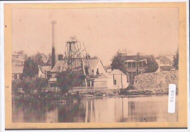
Photograph - View of Hustler's mine
... machine. HE later sold the mine to the Hustlers Reef Mining... machine. HE later sold the mine to the Hustlers Reef Mining ...Named after Thomas Hustler who purchased the lease in 1854. It was an opencut mine at this stage and Hustler patented a quartz crushing machine. HE later sold the mine to the Hustlers Reef Mining and drainage Co. and by 1865 the Great Extended Hustler's was operating 31 levels at a depth of 1053meters. The mine ceased operation in 1921.A4 copy of an original photograph, sepia toned print. View of hustler's Mine facing Barnard Street, Bendigohustler's, barnard street, james brierley -
 Bendigo Historical Society Inc.
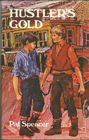
Book - HUSTLER'S GOLD
... the background of Hustlers Reef Bendigo, 126 pages with black and white... set against the background of Hustlers Reef Bendigo, 126 pages ...Hustler's Gold, a childrens' fictional book about 2 youths, best friends, and their escapades all set against the background of Hustlers Reef Bendigo, 126 pages with black and white illustrations by Rachel Tonkin and a map, first published 1969 by Lansdowne Press, hard cover with dustjacket.Pat Spencerbook, bendigo, childrens -
 Bendigo Historical Society Inc.
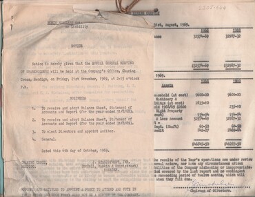
Document - MCCOLL, RANKIN AND STANISTREET COLLECTION: NORTH HUSTLERS GMC - CORRESPONDENCE FILE, 1940 - 1969
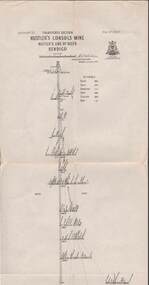
... . Prospectus for Hustlers Reef. Plan of residential area... Hustlers Mine 9.4.1950. Prospectus for Hustlers Reef. Plan ...Document. Bundle of letters, etc bound together with string. Reports for Annual General Meetings including profit & loss statements. Lists of shareholders. Proxy forms. Application for renewal of lease for North Hustlers Mine 9.4.1950. Prospectus for Hustlers Reef. Plan of residential area for application of lease.McColl, Rankin & Stanistreetorganization, business, north hustlers gmc, mccoll, rankin & stanistreet, north hustlers gmc, gold mining, lease, share holders, profit & loss, prospectus, agm -
 Bendigo Historical Society Inc.
Document - LONG GULLY HISTORY GROUP COLLECTION: SOME HISTORICAL INFORMATION
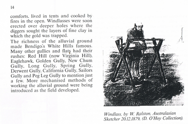
... Hustler's Line of Reef... William Westgarth Latham and Watson Hustler's Line of Reef Bell ...BHS Collection12 photocopied pages. Page four has acknowledgements, Page five mentions Pen-Portraist by Raly Wallace and Kevin Vallence, Page 14 mentions some rich areas: White Hills, Red Hill (now Virginia Hill), Eaglehawk, Golden Gully, New Chum Gully, Long Gully, Spring Gully, Derwent Gully, California Gully, Sailors Gully and Peg Leg Gully. There are two sketches on the page: Windless, by W. Ralston, Australasian Sketcher 20/12/1879 (D O'Hoy Collection) and a sketch of some miners in a tent with some mining equipment in front of it. There are two men in front of a fire at the front of the tent. Page 16 has a sketch of an old brick house with iron lace on the veranda and a picket fence at the front. Page 17 mentions the school and some Friendly Societies and Church. Page 22 mentions Quartz Mining. There is a Lithograph of a Quartz outcrop, New Chum Gully 1852 by George Rowe and a View of Surface Workings 1861, a Batchelder Photo. Page 23 mentions Edward Nucella Emmett, a pioneer gold digger who became involved in many important public issues. Page 25 mentions Company Mining and Crushing. It has a sketch of a Primitive Quart Crusher. Page 37 Mentions Richard Pope, a Miner who tramped from job to job in Bendigo and eventually followed the rush to Broken Hill. Page 38 mentions the Eaglehawk Brass Band and Friendly Societies in Eaglehawk. Page 39 is headed Miner's Cottage. It mentions stone miners' cottages. Page 40 has a sketch of a Georgian Style Sandstone Cottage Harvey Town. Page 41 mentions men sweeping the road to get gold, Bull Family grocery shop and a blacksmith. Page 42 is headed St. Augustine's. Page 43 has a sketch of St. Augustine's Church. Page 59 is headed Bendigo Amalgamated Goldfields (B.A.G.) Edward Clarence Dyason was largely behind a new company set up in 1917 to work the Bendigo field in an entirely new way. (B.A.G.) wished to take over all existing mining companies, and place them under a single management structure.bendigo, history, long gully history group, the long gully history group - some historical information, mr l hooley, mr l bennetts, mr w watson, mr w heraud, mr d m davies, mr w perry, mr h harvey, mr a llewellyn, mr e oates, chook temple by mr alan llewellyn, mr f cusack, tracey ipsen, ray wallace, bendigo field naturalists' club, eaglehawk tree lovers' society, bendigo historical society, university of melbourne, kevin vallence, monash university, bendigo technical college, south australian writer's fellowship, windlass, w ralston, australasian sketcher 20.12.1879, d o'hoy, mechanics institute, california gully school, bell topper hill, i.o.r. (rechabites), cobden tent, refuge tent, sutton tent, m.u.i.o.o.f.'s loyal darling, bible christian church, california hill wesleyan methodist church, saint jude's anglican church, quartz mining, e n emmett, jonathan harris, haris' claim, j hustler, george rowe, batchelder, la trobe library, cave, amos, new chum line of reef, edward nucella emmett, bendigo city council, all saints, william westgarth, latham and watson, hustler's line of reef, bell and irons, ballerstedt and son, young and company, nicholas and bassit, ensor, thomas carpenter, quartz crusher, goldfields and mineral districts of victoria, richard pope, daniel webster mine, isaac dyason, old chum mine, north old chum mine, young chum mine, george lansell, lazarus, silicosis of the lungs, eaglehawk brass band, victoria hotel, mr williams, eaglehawk branch of the australian natives association, loyal catherine lodge, mr james, odd fellows in the loyal catherine lodge branch no 4935, richard harvey, thomas harvey, moonta copper mines, harvey town, national trust of australia, eaglehawk tree lovers society, saint mungo's methodist church, clark's beehive battery, world war 1, kee-young, lady barkly hotel, prankhurst, bull family, cousin jack, st augustine's, myers, nicholls, john o'brien, around the boree log, the rev dean hayes, st kilian's, bendigo amalgamated goldfields (b.a.g.), edward clarence dyason, r h s abbott, hercules and energetic, south new moon, new chum goldfields, central red white and blue consolidated, brown john, the life and times of long gully, bendigo press, val white, megan snoop -
 Bendigo Historical Society Inc.
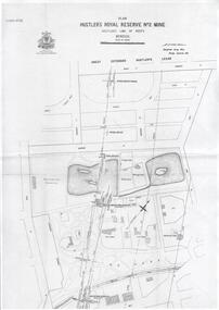
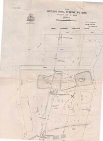
Plan - Hustler's Royal Reserve No. 2 Mine, April, 2014
... Hustler's line of reef... No. 2 Mine Park Shaft Hustler's line of reef Gaol One page plan ...One page plan (photocopy) of Hustler's Royal Reserve No. 2 Mine (Park Shaft) showing mine location, dams, tennis courts, bowling green, Jail (sic) Barnard Street, View Street and Park Road. Whitelaw plan, 1913.goldmining, accident, quartz, mining, hustler's royal reserve no. 2 mine, park shaft, hustler's line of reef, gaol, -
 Bendigo Historical Society Inc.
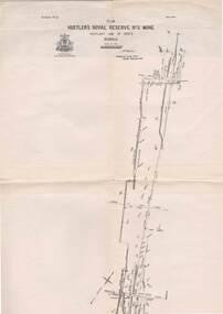
Map - STRUGNELL COLLECTION: HUSTLER'S LINE OF REEFS, BENDIGO, September 1913
... Map, Hustler's Line of Reefs, Hustler's Royal Reserve No.2... Office, Bendigo. Map, Hustler's Line of Reefs, Hustler's Royal ...Map, Hustler's Line of Reefs, Hustler's Royal Reserve No.2 Mine, Bendigo Plan. Plate No.V1 (6). Bulletin No 33 Signed H.A.Whitelaw Underground survey Office Bendigo September 1913Underground Survey Office, Bendigo.map, bendigo, hustler's royal reserve no. 2 mine* -
 Bendigo Historical Society Inc.
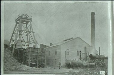
Slide - ALBERT RICHARDSON COLLECTION: HUSTLERS REEF MINE OLD HUSTLERS
... Slide. Hustlers Reef Gold Mine, Old Hustlers, south west... Gold hustlers reef. Bendigo Mines-Jack Hattam Collection ...Slide. Hustlers Reef Gold Mine, Old Hustlers, south west corner Anderson Street and Prouses Rd. Poppet head on LH side, wooden quartz bins in front. Boilers and compressors outside the engine/boiler room. Man standing centre of image in front of engine room. Photo sourced from 'Healthy Golden Bendigo'No. 32 printed on bottom of slidemine, gold, hustlers reef., bendigo mines-jack hattam collection. -
 Bendigo Historical Society Inc.
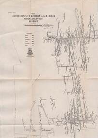
Map - STRUGNELL COLLECTION: UNITED HUSTLER'S & REDAN & K.K.MINES, September 1913
... Map, Hustler's Line of Reefs, United Hustler's & Redan... Map, Hustler's Line of Reefs, United Hustler's & Redan ...Map, Hustler's Line of Reefs, United Hustler's & Redan & K.K.Mines, Bendigo. Plate No. XXV111 (28),Bulletin 33.Signed H.A.Whitelaw. Drawing seems with their respective mineral contentsUnderground Survey Officemap, bendigo, united hustler's, redan, k.k.mines -
 Bendigo Historical Society Inc.
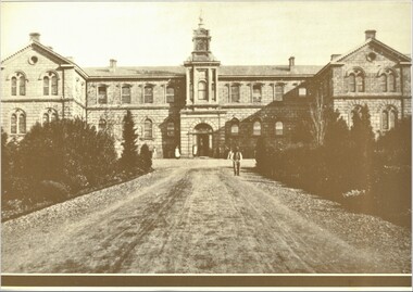
Photograph - PHOTOGRAPHS OF BENDIGO (COPIES)
... Hospital b. Hustler's Reef Mine Bendigo c. View Street Bendigo d... photographs of Bendigo. a. Bendigo Hospital b. Hustler's Reef Mine ...Seven copies of sepia photographs of Bendigo. a. Bendigo Hospital b. Hustler's Reef Mine Bendigo c. View Street Bendigo d. Shamrock Hotel (second Building). e. City Family Hotel f. Old Chum Claim g. Old Chum Hill Enlarged copies of photos. Each photo has a 1.2 cm brown border.bendigo, history, buildings/streetscapes -
 Bendigo Historical Society Inc.
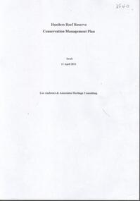
Document - HUSTLERS REEF RESERVE CONSERVATION MANAGEMENT PLAN
... , for the Hustlers Reef Reserve. The reserve cover the site of the former... & Associates, Heritage Consultants, in 2011, for the Hustlers Reef ...Conservation management plan (112 pages) prepared by Lee Andrews & Associates, Heritage Consultants, in 2011, for the Hustlers Reef Reserve. The reserve cover the site of the former Great Extended Hustlers Mine site. Leigh McKinnons amendments to the plan are included with the document. History of the site, a physical survey and analysis, comparative analysis, cultural significance and conservation policy are addressed in the document.bendigo, mining, great extended hustlers mine site -
 Bendigo Historical Society Inc.
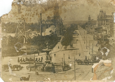
Photograph - PURDY COLLECTION: PALL MALL PHOTO
... On back of image in biro 'Royal Reserve G.M., Hustlers... 'Royal Reserve G.M., Hustlers line of reef, Pall Mall, Bendigo ...Sepia image of Pall mall, taken from just south of the Alexandra Fountain. Shows horse drawn vehicles, people walking. Women dressed in long dresses, tramline on road, tram heading up towards View Street. Poppet head and mining chimney of Royal Reserve mine on LH side of Pall Mall. Post Office and Shamrock buildings on either side in mid-ground. On back of image in biro 'Royal Reserve G.M., Hustlers line of reef, Pall Mall, Bendigo.'bendigo, streetscape, pall mall -
 Bendigo Historical Society Inc.
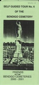
Document - BENDIGO CEMETERIES COLLECTION: SELF GUIDED TOUR NO. 6 DOCUMENT
... Dumphy miner of Hustler's reef, erected by Bendigo Miners... in this cemetery ) John Dumphy miner of Hustler's reef, erected by Bendigo ...BHS CollectionGreen trifold document: Self Guided Tour No. 6 of the Bendigo Cemetery. Friends of the Bendigo Cemeteries 2000 - 2001. Theme : Federation: 100 years later, our Heritage. Map with 26 numbered graves, includes J.C.T. Ballerstedt, Christiana Atkinson ( Dr. Atkinson buried 4 wives in this cemetery ) John Dumphy miner of Hustler's reef, erected by Bendigo Miners Accident Society.Friends of the Bendigo Cemeteries Inc 2000bendigo, cemetery, bendigo cemetery tour -
 Bendigo Historical Society Inc.
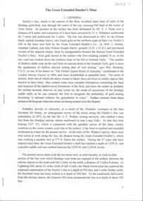
Document - Great Extended Hustlers Gold Mine, Albert Richardson
... Hustlers Reef Q.M. Co.. Topics include: general overview of history... Hustlers Reef No. 1 Hustlers Reef Hustlers Royal Reserve Co. Park ...Seven men were killed at the Great Extended Hustler's mine disaster on 2nd May 1914 by an explosion of dynamite occurring as the men were waiting at the plat to ascend the mine at the end of their shift. No blame was attached to anyone in the findings of the inquisition. It was unknown what caused the dynamite to explode. This document formed part of the research done at the time by Bendigo Historical Society, of the 100 years commemoration of the mine disaster, held at Hustlers Hill in 2014. Six page copy of research document, describing the history and geology of the Great Extended Hustlers Mine and the Great Extended Hustlers Reef Q.M. Co.. Topics include: general overview of history, mines along the Hustlers line, characters of the saddle reefs, gold occurrences, effect of pitch, influence of faulting, payable reefs and saddle reefs and spurs. Mine overview researched by Mr. Albert Richardson. great extended hustlers, goldmining, hustlers consols, united hustlers and redan, k.k. mine, comet, hustlers reef no. 1, hustlers reef, hustlers royal reserve co., park shaft, hustlers royal reserve no. 2, city shaft, fortuna hustlers -
 Bendigo Historical Society Inc.
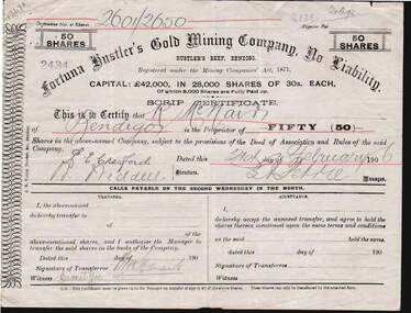
Document - KELLY AND ALLSOP COLLECTION: SHARE CERTIFICATES - FORTUNA HUSTLER'S GOLD MINING CO, 21/02/1908
... Mining Company, No Liability, Hustler's Reef Bendigo. Each..., Hustler's Reef Bendigo. Each certificate represents 50 shares @ 30 ...Document. KELLY & ALLSOP COLLECTION. Two share certificates (Nos. 2434 & 2435) issued by the Fortuna Hustler's Gold Mining Company, No Liability, Hustler's Reef Bendigo. Each certificate represents 50 shares @ 30 shillings each and issued to R.McNair of Bendigo on 21 Feb.1906. Capital raised was 42,000 Pounds from 28,000 shares. Certificates signed by G.H.Petrie, Manager. Printed by J.B.Young, Bendigo.Fortuna Hustler's Gold Mining Co.business, stockbroker, kelly & allsop, kelly & allsop collection, share certificates, fortuna hustler's gold mining co., r.mcnair, g.h.petrie, j.b.young. -
 Bendigo Historical Society Inc.
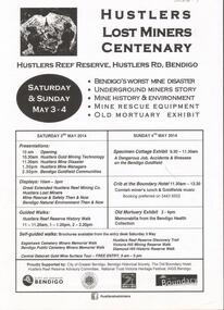
Document - GREAT EXTENDED HUSTLERS GOLD MINE: LOST MINERS FLYER FOR CENTENARY OF MINE DISASTER
... a Specimen Cottage exhibit; guided walks around the Hustlers Reef... walks around the Hustlers Reef Reserve; displays on site ...On May 2nd 1914, 7 miners were killed in a dynamite explosion in the Great Extended Hustler's Gold Mine. It was Bendigo's worst mining disaster and although an inquest found it was an accident, no cause for the explosion was found.Advertising flyer for an event held on May 3-4 2014, to mark the centenary of the mine disaster that killed 7 minersat the Great Extended Hustlers mine. Other activities included a Specimen Cottage exhibit; guided walks around the Hustlers Reef Reserve; displays on site and talks by various speakers on the mine disaster and mining technology. Event was organised by the Bendigo Historical Society in conjunction with the Hustlers Reserve committee. -
 Bendigo Historical Society Inc.
Document - CORRESPONDENCE TO BHS RE: CROCKER FAMILY
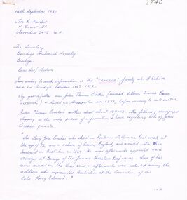
... 1869 - 1912. Manager - Hustlers Reef mine. Reply from BHS... Hustlers Reef mine Mining Board Wesleyan School-House View Point ...Correspondence to BHS re Crocker family - lived in Bendigo 1869 - 1912. Manager - Hustlers Reef mine. Reply from BHS: ''1891 - Mr Crocker was a member of the Mining Board''. A bracketed comment makes reference that the Mr. Crocker referred to in this letter may not have been the to which you refer. The reply make reference to a Mr. Crocke who attended the opening service of the Wesleyan School-house, situated at View Point Sandhurst.person, individual, crocker family, james thomas croker, king edwards, hustlers reef mine, mining board, wesleyan school-house, view point sandhurst. -
 Bendigo Historical Society Inc.
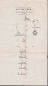
Map - STRUGNELL COLLECTION: HUSTLER'S LINE OF REEFS, September 1913
... Map, Hustler's Line of Reefs, Hustler's Consols Mine.... Map, Hustler's Line of Reefs, Hustler's Consols Mine ...Map, Hustler's Line of Reefs, Hustler's Consols Mine, Transverse Section, Bendigo.Plate no. XXX111 (33).Bulletin No 33 Signed H.A.Whitelaw. Drawing shows the vertical shaft descending to over 1326 feet and appears to show samples of connecting horizontal shafts with their respective mineral contentsUnderground Survey Office, Bendigo.map, bendigo, hustler's consols mine -
 Bendigo Historical Society Inc.
Document - KELLY AND ALLSOP COLLECTION: SHARE CERTIFICATES - UNITED HUSTLER'S & REDAN COMPANY, 22/07/1912 to 26/10/1914
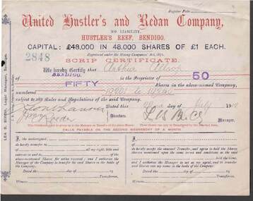
... issued by the United Hustler's and Redan Company, Hustler's Reef... by the United Hustler's and Redan Company, Hustler's Reef, Bendigo. Each ...Document. KELLY & ALLSOP COLLECTION. 2 Share Certificates issued by the United Hustler's and Redan Company, Hustler's Reef, Bendigo. Each certificate represents 50 shares at One Pound each. Capital raised was 48,000 Pounds from 48,000 shares. Certificate No. 2848 issued to Arthur Allsop of Bendigo on 22 July 1912. Certificate No. 2620 issued to A.Allsop of Bendigo on 26 Oct 1914. Both certificates signed by Lea B.Birch, Legal Manager.United Hustler's & Redan Co.business, stockbroker, kelly & allsop, kelly & allsop collection, united hustler's & redan co., gold mining, share certificates, arthur allsop, lea b.birch -
 Bendigo Historical Society Inc.
Document - LONG GULLY HISTORY GROUP COLLECTION: HUSTLERS LINE OF REEF
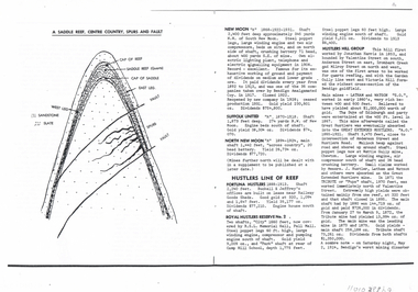
... Page mentioning mines on the Hustlers Line of Reef... Group - Hustlers Line of Reef Fortuna Hustlers Buckell ...Page mentioning mines on the Hustlers Line of Reef. The are: Fortuna Hustlers, Royal Hustlers Reserve No 2 - City and Park Shafts, Great Hustlers, Latham, Watson, Great Extended Hustlers, Tribute or Pups Shaft, Bendigo's Worst Mining Disaster May 2 1914, Hustlers Reef (Old Hustlers) and Hustlers Reef No 1, Lansell's Comet Lightening Hill Line, The Old Comet (Cooper's Claim), United Hustlers and Redan, K K Shaft, North or New Hustlers (once known as Agnew Hustlers), Derby Line - Johnson's No 3, Paddy's Gully Line, Lansell's 'Sandhurst' (Needle), Needle Loops, Cleopatra Needle top, British American, Collman and Tacchi and South Virginia. Also mentioned is Total Gold Yield, Main Shafts on Field, Price of Gold (Old Currency) and Saddle Reefs and Spurs. Also mentioned are New Moon, Suffolk United, South New Moon and North New Moon. There is a diagram of a Saddle Reef, Centre Country, Spurs and Fault. Depth of shaft, machinery, location, dividends and yields are also mentioned. Price of Gold (Old Currency): 1851-1930, Price varied from Approx. £3/17/6 to £4 per ounce. 1938, from £6/19/10 to £7/8/10 per ounce. 1946/47/48 £10/15/3 per ounce, May 1, 1954 £15/12/6 per ounce.bendigo, history, long gully history group, the long gully history group - hustlers line of reef, fortuna hustlers, buckell & jeffrey's, railway goods sheds, rsl memorial hall, camp hill school, royal hustlers reserve no 2 - city and park shafts, jonathan harris, latham and watson, great hustlers, great extended hustlers, wattle gully mine, messrs j hustler latham and watson, tribute or pups shaft, bendigo's worst mining disaster, hustlers reef (old hustlers) and hustlers reef no 1, lansell's comet, the old comet (cooper's claim, united hustlers and redan, k k shaft, north or new hustlers (once known as agnew hustlers), derby line - johnson's no 3, pa ddy's gully line, lansell's 'sandhurst' (needle), needle loops, cleopatra needle top, british american, collman and tacchi, south virginia, saddle reefs and spurs, new moon, suffolk united, south new moon, north new moon -
 Bendigo Historical Society Inc.
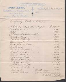
Document - COHN BROTHERS COLLECTION: LIST OF PROPERTY VALUATIONS DATED 1891
... : Albert Hotel, Fire Brigade, City, British American, Hustlers Reef..., Hustlers Reef, Garden Gully, Universal, Brougham Arms, Victoria ...Printed Cohn Bros Memorandum letterhead notepaper dated 23rd Dec 1891 with handwritten 'Property Valuations'. Nineteen Cohns Hotels with 1891 valuations are listed. These include: Albert Hotel, Fire Brigade, City, British American, Hustlers Reef, Garden Gully, Universal, Brougham Arms, Victoria, United Kingdom, West End, View Bend, Sparrowhawk, Greyhound, Normanby, Noahs Ark, Saw Mills, and the Royal at Wedderburn, as well as the South Elmore at the township of Elmore. These totalled £14,305bendigo, industry, cohn bros brewery -
 Bendigo Historical Society Inc.
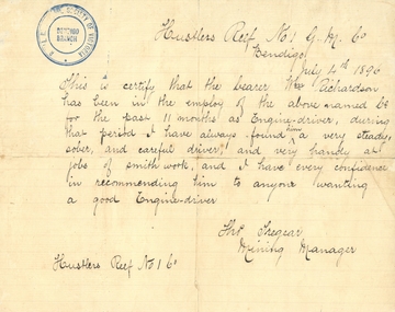
Document - HUSTLERS REEF MINE - REFERENCE FOR WM RICHARDSON
... the Hustlers Reef No 1 G. M. Co. Dated July 4th, 1896. Blue stamp...MINE Gold hustlers reef mine William Richardson Tho Tregear ...Handwritten reference for William Richardson. It mentions he has been employed as an engine driver and is very handy at smith work. Signed by Tho Tregear, Mining Manager from the Hustlers Reef No 1 G. M. Co. Dated July 4th, 1896. Blue stamp of Royal Historical Society of Victoria, Bendigo Branch in the top left corner. Also, another piece of paper mentioning William Richardson is the grandfather of Albert Richardson who wrote notes on mines.mine, gold, hustlers reef mine, william richardson, tho tregear -
 Bendigo Historical Society Inc.
Newspaper - JENNY FOLEY COLLECTION: DIGGINGS
... : the Hustler's line of reef, as seen from Redan Hill.... "The way we were" from 1999. Diggings: the Hustler's line of reef ...Bendigo Advertiser "The way we were" from 1999. Diggings: the Hustler's line of reef, as seen from Redan Hill.newspaper, bendigo advertiser, the way we were -
 Bendigo Historical Society Inc.
Document - GREAT EXTENDED HUSTLERS MINE - HUSTLERS LINE PECULIARITIES
... Hand written notes on the peculiarities of the Hustlers... saddle reef. Document GREAT EXTENDED HUSTLERS MINE - HUSTLERS ...Hand written notes on the peculiarities of the Hustlers Line of Reef. Notes on pitch of the reef and a peculiar type of false saddle reef.mine, gold, great extended hustlers., great extended hustlers mine, peculiarities of the reef, pitch of reef, false saddle reefs -
 Bendigo Historical Society Inc.
Map - STRUGNELL COLLECTION: HUSTLER'S LINE OF REEFS, BENDIGO, September 1913
... Map, Hustler's Line of Reefs, Hustler's Royal Reserve... Office, Bendigo. Map, Hustler's Line of Reefs, Hustler's Royal ...Map, Hustler's Line of Reefs, Hustler's Royal Reserve No. 2 Mine, Bendigo.Plate No. V (5).. Great Extended Hustler's Lease, Imperial Hustler's, Hustler's Royal Reserve No. 2 Park & Main Shafts, Fortuna Hustler's Lease.Bulletin No 33 Signed H.A.Whitelaw Underground survey Office Bendigo September 1913Underground Survey Office, Bendigo.map, bendigo, hustler's royal reserve no. 2 mine* -
 Bendigo Historical Society Inc.
Map - STRUGNELL COLLECTION: HUSTLER'S Royal Reserve Shaft No. 2 Bendigo, September 1913
... Map, Hustler's Line of Reef, Hustler's Royal Reserves No. 2... Survey Office, Bendigo. Map, Hustler's Line of Reef, Hustler's ...Map, Hustler's Line of Reef, Hustler's Royal Reserves No. 2 Co, Longitudinal Section.Plate No.V111 (8). Bulletin No 33 Signed H.A.Whitelaw Underground survey Office Bendigo September 1913 Drawing shows mine shaft to over 1746 feet deep and appears to show samples of connecting horizontal shaftsUnderground Survey Office, Bendigo.map, bendigo, hustler's royal reserve no. 2 mine* -
 Bendigo Historical Society Inc.
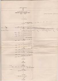
Document - The Flooded Mine, John McCaviston's Escape, April, 2014
... the events that surrounded the flooding that occurred at the Hustlers... the flooding that occurred at the Hustlers Reef Company's mine on 13th ...Seven men were killed at the Great Extended Hustler's mine disaster on 2nd May 1914 by an explosion of dynamite occurring as the men were waiting at the plat to ascend the mine at the end of their shift. No blame was attached to anyone in the findings of the inquisition. It was unknown what caused the dynamite to explode. Three page typed document by Albert Richardson. Copy of handwritten document. 'The Flooded Mine, John McCaviston's Wonderful Escape' by G. Mackay (History of Bendigo). Article details the events that surrounded the flooding that occurred at the Hustlers Reef Company's mine on 13th December 1873. Water was being drained from the adjoining old workings of Latham and Watson, when the flow increased markedly, causing flooding. John McCaviston was the 'shift boss'., R. Jackson the Manager. McCaviston was saved after spending over 20 hours in a level.3527.2 on bottom of all pages. Duplicate copy. great extended hustlers, goldmining, accident, quartz, mining, flooding of mine, john mccaviston, mine rescue, r. jackson, latham and watson -
 Bendigo Historical Society Inc.
Map - STRUGNELL COLLECTION: HUSTLER'S LINE OF REEFS, BENDIGO, September 1913
... Map, Hustler's Line of Reef, Hustler's Royal Reserve No. 2... Office, Bendigo. Map, Hustler's Line of Reef, Hustler's Royal ...Map, Hustler's Line of Reef, Hustler's Royal Reserve No. 2, Park Shaft, Bendigo, Plate No. 1X (9). Bulletin No 33 Signed H.A.Whitelaw Underground survey Office Bendigo September 1913 Drawing shows mine shaft to over 1099 feet deep and appears to show samples of connecting horizontal shafts with their respective mineral contentsUnderground Survey Office, Bendigo.map, bendigo, hustler's royal reserve no. 2 mine* -
 Bendigo Historical Society Inc.
Document - ''THE TRUE LIFE STORY OF THIS OLD BENDIGO MINER'' W (BILL) A LANGLEY, 21st April, 1967
... , Market Square); Hercules and Energetic mine; Hustlers Reef mine... Mine Energetic Mine Sea Company Mine Hustlers Reef Mine Jim ...''The true life story of this old Bendigo miner'' W (Bill) A Langley. Seven typewritten pages of reminiscences of various types of (labouring) work. As provided by author,21/4/1967, aged 82 years. Mention of breweries in Bendigo (Bruce; Pritchard; Chamberlin; Cohn Bros; Hunter Bros; Stewards (Eaglehawk); Italian contractor - G. Vanosio (Back Creek); George Edwards (skin buyer, Market Square); Hercules and Energetic mine; Hustlers Reef mine; Prices of various things purchased in late 1890s; costs of various entertainments at that time.W.A. Langleyperson, individual, w. a. langley, new chum railway mine, mr charles rowe, chinese camp at ironbark and bridge street, bob lewis, jim scobie, bob lewis, bruce brewery, pritchard and chamblin, cohn bros, hunter bros, illingsworth and stewards brewery, white hills cemetary, george edwards, harry hoy, g. svanosio, back creek, hercules mine, energetic mine, sea company mine, hustlers reef mine, jim mcdonald, bendigo pottery, beehive exchange. -
 Bendigo Historical Society Inc.
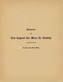
Document - MCCOLL, RANKIN AND STANISTREET COLLECTION: PROSPECTUS NEW ENGLAND TIN MINES NL, 1934
... No Liability. Hustlers Reef, Eaglehawk, Bendigo. January 1940... Mining Company NL Hustlers Reef Eaglehawk Bendigo McColl Rankin ...McColl Rankin & Stanistreet. A/ Prospectus New England Tin Mines NL. Contains prospectus on New England Tin Mines NL, Torington, NSW. Markings/inscriptions: Prospectus of New England Tin Mines NL' on front cover. Includes Application for Shares on loose sheet. B/ Prospectus of North Hustlers Gold Mining Company No Liability. Hustlers Reef, Eaglehawk, Bendigo. January 1940. Inscriptions/Markings: Stamp John May & Sons Stock & Share Brokers, 90 Queen St., Melbourne, stamped on front cover and inside back cover.organization, mining, north hustlers gold mining co nl, mccoll rankin & stanistreet new england tin mines nl prospectus of north hustlers gold mining company nl hustlers reef eaglehawk bendigo