Showing 176 items matching " land brochures"
-
 Greensborough Historical Society
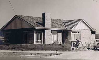
Book, Typical Homes that would be constructed by Mitchell Trading Pty Ltd, 1960_
An early advertising brochure for prospective homeowners to choose the style of home they would like built. House and land packages were available in the areas of Bundoora surrounding the Loyola and Parade College sites, which were monasteries in the 1960s. The aerial photographs show the open nature of the landscape from Bundoora across to Greensborough and Watsonia in the 1960s. Book of black and white photographs bound in brown card cover. Contains 14 photos of houses and shops and 14 aerial photos of Bundoora including the Loyola and Parade College areas. Includes notes from Gary Partington.In pencil inside front cover: 29/1/1960.houses, bundoora, greensborough, watsonia, loyola college, parade college, mitchell trading, aerial photography -
 Greensborough Historical Society
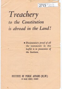
Leaflet, Institute of Public Affairs (N.S.W), Treachery to the constitution is abroad in the land!, 1949_
Brochure issued by the Institute of Public Affairs prior to the 1949 Australian federal election criticising the Labor government policy of bank nationalisation.The Australian Labor Party's bank nationalisation policy was strenuously opposed by conservative parties and organisations, and probably was a significant factor in its loss of the 1949 federal election.Leaflet 4 p. printed in black on white paperinstitute of public affairs (n.s.w), australian labor party, bank nationalisation, politics -
 Glenelg Shire Council Cultural Collection
Pamphlet - Brochure, Steam Packet Inn, n.d
The Steam Packet Inn is the second oldest building in Portland. It was licensed to an ex convict from Van Diemens Land (Tasmania) in 1841. Later became a police barracks. It is a heritage listed buildingYellow card, tri-fold brochure, containing history of Steam Packet Inn, Bentinck St. Portland. Photo of steam Packet Inn on front of brochure, floor plans on the back.steam packet inn, bentinck street, portland -
 Kiewa Valley Historical Society
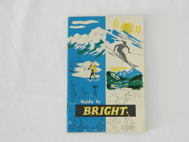
Pamphlet - Bright Tourism, Guide to Bright and District, late 1900s
This publication was produced in the early 1950s to provide the growing tourism trade (at this time), to the region with a more detailed overview of the facilities available to tourists of the region's attractions. This brochure is a very efficient and effective promotional publication. The increasing level of self promotion by local business and commerce sectors of the region the more sought after the region became and the greater the ability of the region to grow (non rural based economy). Some of the regions unique facilities and geological structures are well suited to those tourists who live in cities and "flat land" regional bush areas within Australia. This was a period when the average Australian domestic tourist was more able (finance and transport wise) to see more of their country within the short time they had for "holidays". In the late 1900s, however, with the increase to workers' recreational leave and better transportation (fares, ease of travel to overseas destinations) the local tourism numbers from other domestic locations have been steadily declining. From the 1970s onwards, the increased tourism demand from overseas tourists, for better facilities and easier access to these regional facilities, resulted in better transport, accommodation and communication, which has been a boon for all tourism within Australia. In the 21st century the world is becoming smaller and smaller for the international tourist, especially for those from crowded Asian cities. The greater attraction for "open" spaced locations such as this region are becoming a much sought after change of scenery. This pamphlet which targets the tourist, whether either from other Australian regions or the global tourist, is a good example of self promotion by a relatively small local population. This is especially significant because before the "tourist explosion" in the 1950s onward, these regional areas had a more introspective society with greater emphasis to locally established mores and values. The increased interactions with people from other areas and nations, combined with a greater global communication network is affecting those traditionally established mores to produce a some what unique social transformation which is constantly changing from one generation to the next. One important factor which tourism does bring is that it opens up the region to a wider range of people who look to the region for their own lifestyle changes.This pamphlet has a front cover in colour with the major activities in the region sketched depicting : sunshine, snow skiing, trout fishing, mountain climbing, golfing, swimming, alpine views, tennis, lawn bowls and picnics. The back cover is blank. The pamphlet is fastened together by two staples 30mm from top and bottom, and is folded with the cover slightly thicker than the fifteen pages. Thirteen pages have been printed on both sides. The first page has a black and white photograph of the hotel Alpine and the tall brick constructed Clock Tower. There are another five black and white photographs in the pamphlet.on front cover "Guide to BRIGHT"local tourism, regional information booklet, "time" related brochures, alpine local history -
 Kiewa Valley Historical Society
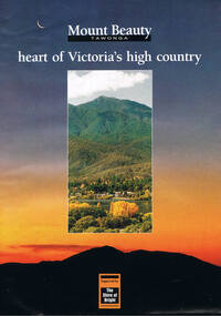
Poster Brochure, Mt Beauty Tawonga Heart Of Victoria's High Country, Circa 1995
The Item is a pictorial time piece of the valley and usage, farms,industry,town area, vegetation and winter snow levels Historical and the social-economical development at circa 1995 of land usage and residential buildings style.Major social events e.g. Festival of the Bogong Moth and the Mt Beauty Mardi Gras. It is also a good historical record of tourism campaigns of the Alpine Shire and Mt Beauty Chamber of Commerce. Also see "KVHS 0125"Brochure folds out from a 20.5cm x 29.5cm to 82cm x 29.5cm poster type documentinside panoramic photo of snow tipped alpine mountain range incorporating the Mount Beauty township, farming area of the Kiewa Valley and relevant tourist orientated informationtourism mt beauty tawonga photographs, victorian alps -
 Eltham District Historical Society Inc
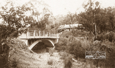
Negative - Photograph, The Bridge, Hurstbridge, Vic, c.1925
Copied from brochure "Wattle Valley Estate" 7 minutes from the bridge. The new bridge designed by Sir John Monash over the Diamond Creek near Hurst's home of 'Mia Mia' at Hurstbridge. The Wattle Valley Estate was first advertised in August 1925 as weekend building allotments by the Greater Melbourne Land and Development Company. Advertised from £28.10.0 or £60 per block. In August 1926, 30 picked allotments of 60x150 feet were put up for auction Saturday August 14, 1926 with frontages to Valley View Road and Fawkner Crescent advertised in the “Heart of the Glorious Wattle Country” and “Within 15 Minutes of the Newly Electrified Railway Station”. The Advertiser on August 13, 1926 in an article promoting the auction stated “the estate is regarded as one of the best in the district, and will be sold practically without reserve.” It is noted that an advertisement running in The Argus February 22, 1951 offered the remaining 16 blocks for sale at £12.10.0 or £200 the lot. By March 7, the remaining blocks were advertised at £17.10.0 The Wattle Valley Estate took over 20 years to sell and then people could not build on them This image was also used in a brochure advertising the "Wattle Valley Estate", which forms part of the Shire of Eltham Pioneers Photograph Collection (Cross Reference Photo No.(s): 1056, 1057)This photo forms part of a collection of photographs gathered by the Shire of Eltham for their centenary project book,"Pioneers and Painters: 100 years of the Shire of Eltham" by Alan Marshall (1971). The collection of over 500 images is held in partnership between Eltham District Historical Society and Yarra Plenty Regional Library (Eltham Library) and is now formally known as the 'The Shire of Eltham Pioneers Photograph Collection.' It is significant in being the first community sourced collection representing the places and people of the Shire's first one hundred years.Digital image 4 x 5 inch B&W Negshire of eltham pioneers photograph collection, hurstbridge, bridge, diamond creek (creek), monash bridge, wattle valley estate -
 Eltham District Historical Society Inc
Negative - Photograph, Rose Stereograph Company, The Bridge, Hurstbridge, Vic, c.1925
Copied from brochure "Wattle Valley Estate". The new bridge designed by Sir John Monash over the Diamond Creek near Hurst's original home "Mia Mia" seen in the distance. Reprinted from brochure advertising "Wattle Valley Estate" 7 minutes from bridge. The Wattle Valley Estate was first advertised in August 1925 as weekend building allotments by the Greater Melbourne Land and Development Company. Advertised from £28.10.0 or £60 per block. In August 1926, 30 picked allotments of 60x150 feet were put up for auction Saturday August 14, 1926 with frontages to Valley View Road and Fawkner Crescent advertised in the “Heart of the Glorious Wattle Country” and “Within 15 Minutes of the Newly Electrified Railway Station”. The Advertiser on August 13, 1926 in an article promoting the auction stated “the estate is regarded as one of the best in the district, and will be sold practically without reserve.” It is noted that an advertisement running in The Argus February 22, 1951 offered the remaining 16 blocks for sale at £12.10.0 or £200 the lot. By March 7, the remaining blocks were advertised at £17.10.0 The Wattle Valley Estate took over 20 years to sell and then people could not build on them This image was also used in a brochure advertising the "Wattle Valley Estate", which forms part of the Shire of Eltham Pioneers Photograph Collection (Cross Reference Photo No.(s): 1056, 1057). Also cross reference SEPP_1028 / 29 for other views of Mia Mia. Part of a slide show presentation "Bridges & Waterways of the Shire" by Russell Yeoman to the 13 September 1989 Society meeting. The presentation included slides of historic photos from the Shire of Eltham Pioneers collections as well as several recent views. This photo forms part of a collection of photographs gathered by the Shire of Eltham for their centenary project book,"Pioneers and Painters: 100 years of the Shire of Eltham" by Alan Marshall (1971). The collection of over 500 images is held in partnership between Eltham District Historical Society and Yarra Plenty Regional Library (Eltham Library) and is now formally known as the 'The Shire of Eltham Pioneers Photograph Collection.' It is significant in being the first community sourced collection representing the places and people of the Shire's first one hundred years.Digital image 4 x 5 inch B&W Negshire of eltham pioneers photograph collection, hurstbridge, mia mia, bridge, diamond creek (creek), monash bridge, wattle valley estate -
 Eltham District Historical Society Inc
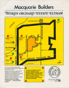
Document, Stokes Orchard Estate Eltham; Macquarie Builders, 1979c
Sales brochure including photocopy map of Stokes Place lots and Sales Manager's business card (John J. Herold). Stage 1 implemented c.1976 and Stage 2 c.1979. As shown on the plan, the lots along Diosma Road did not eventuate due to the lack of sewer system. These lots and streets were divided up into 5 acre blocks, which were not able to be subdivided till the 1990s when the sewer was run up Diosma Road. Stokes Place was part of the Stokes Orchard Estate which was developed from the break-up of the the orchard owned by Frank Stokes who lived on the northeast corner of Nyora Road and Eucalyptus Road. His daughter Beryl advised that the Shire had levied a rate assessment on individual parcels of land within the orchard which became unaffordable resulting in its sub-division and sell off. The Stokes Orchard Estate was developed by Macquarie Builders in two stages starting with stage 1 in 1976. Stokes Place was part of Stage 2 in 1979. The Estate was bounded between Nyora Road, Eucalyptus Road, Diosma Road and Stokes Place. The original orchard only just reached the left most portions of Stokes Place and did not go fully up to Diosma, rather to just beyond the extant of Stokes Place. Stokes Place was known within the family as "The Oats" as that is where they grew oats. Frank Stokes moved to Eltham c.1945 after visiting Harold Bird to view his orchard, located diagonally opposite Stokes Orchard from the intersection of Eucalyptus Road, Pitt Street and Nyora Road. It was on Harold Bird's recommendation that Frank purchased the land.The Stokes Orchard Estate collection is typical of housing developments of the late 1970s and 1980s. It was one of the earliest estates in Eltham following the nearby Woodridge Estate development.A4 colour brochure double sided, A4 photocopy and business cardAs notedstokes place, eltham, stokes orchard, stokes orchard estate, streets, houses, peter and carla vermey -
 Eltham District Historical Society Inc
Photograph - Postcard, The Bridge, Hurstbridge, Vic
Arched Bridge (Monash Bridge) The Rose Series P. 4036 Reproduced in a brochure advertising the "Wattle Valley Estate" 7 minutes from the bridge. The new bridge designed by Sir John Monash over the Diamond Creek near Hurst's original home "Mia Mia" seen in the distance. The Wattle Valley Estate was first advertised in August 1925 as weekend building allotments by the Greater Melbourne Land and Development Company. Advertised from £28.10.0 or £60 per block. In August 1926, 30 picked allotments of 60x150 feet were put up for auction Saturday August 14, 1926 with frontages to Valley View Road and Fawkner Crescent advertised in the “Heart of the Glorious Wattle Country” and “Within 15 Minutes of the Newly Electrified Railway Station”. The Advertiser on August 13, 1926 in an article promoting the auction stated “the estate is regarded as one of the best in the district, and will be sold practically without reserve.” It is noted that an advertisement running in The Argus February 22, 1951 offered the remaining 16 blocks for sale at £12.10.0 or £200 the lot. By March 7, the remaining blocks were advertised at £17.10.0 The Wattle Valley Estate took over 20 years to sell and then people could not build on them.Digital file only Postcards scanned from the collection of Michael Aitken on loan to EDHS, 13 Feb 2018michael aitken collection, postcards, hurstbridge, monash bridge, bridge, diamond creek (creek), mia mia, shire of eltham pioneers photograph collection, wattle valley estate -
 Ringwood and District Historical Society
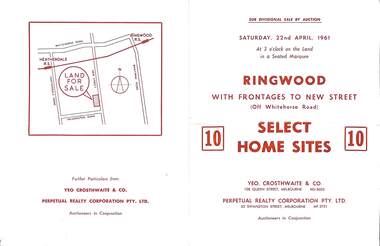
Flyer, Auction sale brochure advertising home sites with frontages to New Street, Ringwood, Victoria - 1961
Advertisement for Sub-divisional sale by auction on Saturday, 22nd April, 1961, with terms of sale of 10 home sites with frontages to New Street, Ringwood, Victoria.Location map showing land for sale on New Street, Ringwood, north of Palmerston Road. Auctioneers in conjunction - Yeo, Crosthwaite & Co., 108 Queen Street Melbourne (Telephone) MU 8605, and Perpetual Realty Corporation Pty. Ltd., 62 Swanston Street, Melbourne (Telephone) MF 3721. -
 Ringwood and District Historical Society
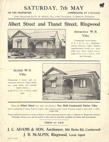
Flyer, Auction Sale Brochure - Adjoining Weatherboard Villas, Albert Street and Thanet Street, Ringwood - circa 1921
Single page advertisement with black and white photographs of two adjoining timber villas fronting Albert Street and Thanet Street, Ringwood for auction on Saturday, 7th May (1921?).Under instructions from E.W. Smail, esq., Public Accountant, 31 Queen Street, Melbourne. Two well constructed timer villas, each containing 5 rooms, electric light, bath and laundry, good position, land to each 66ft x 258 ft., made road. These well-built homes, so nicely situated in this charming district, only 6 minuts to Ringwood Station, Churhes, Shops, etc., are for positive sale, and are specially suitable for homes and in estments. Terms at sale. J.C. Adams & Son, Auctioneer, 364 Burke Road, Camberwell. J.B. McAlpin, Ringwood, Local Agent. -
 Ringwood and District Historical Society
Flyer, Stillwell & Stephens Pty. Ltd, Brochure - Multiple Properties for Public Auction at Box Hill, Ringwood, Wonga Park and Clarinda - 28th November, 1934
... on 10 acres of land. Seven-page brochure advertising Mortgagees ...Seven-page brochure advertising Mortgagees' Realising Sale by Public Auction on Wednesday, 28th November, 1934 for properties at Box Hill, Ringwood, Wonga Park, and Clarinda (via Oakleigh), including photographs, property descriptions, and terms of sale.Auction Commencing at 2.15 p.m. in the Orient Line Auction Rooms, 352 Collins Street, Melbourne. Solicitors: Messrs. Madden, Butler, Elder & Graham, 406 Collins Street, Melbourne. (Agents) H.P. Knight & Co. Property Salesmen and Subidivisional Experts, 315 Collins Street, Melbourne, 'Phones: Central 10615, 10616. Attractive Residential, Orchard, and Market Garden Properties, and Public Hall and School Rooms. 1. Wonga Park via Ringwood - "Holme Bush" off Warrandyte Road, Part of Lots 14 and 15, Ringwood Orchard Estate, approximatgely three miles (north) of Ringwood Railway Station - 64 Acres. 2. 17 Bishop Street, Box Hill - timber residence. 3. Greenwood Avenue, Ringwood - On East Side, 150 feet 3 inches South of Bedford Road - timber attic residence. 4. Ringwood - Wantirna Road, South-east corner of Canterbury Road - Orchard Property of approx. 11-1/2 Acres. 5. Box Hill - Whitehorse Road, South-east corner of Linsley Street - Timber building utilised as a Public Hall and Private School. 6. Clarinda vic Oakleigh, Talbot Crescent, off Centre Road - Home on 10 acres of land. -
 Ringwood and District Historical Society
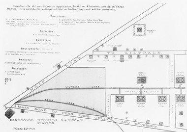
Pamphlet, G.A. Green, Auction Sale Brochure - Garden Farms Estate, Ringwood, Victoria - 1919, 1919
Multi-fold brochure advertising public auction of one-acre, 2-acre, 5-acre and 8-acre allotments in Ringwood and Bayswater on Saturday 12th April, 1919. Brochure includes terms of sale, description of subdivision features and local facilities, and photographic images of the area.Subdivison includes Canterbury Road Heathmont, Armstrong Road Heathmont, Armstrong Road Bayswater, Bungalook Road Heathmont, Bungalook Road Bayswater, and Orchard Road Bayswater. Road shown as Bayswater Road to Bayswater became Mountain Highway Bayswater. Vendor: H.E.B.Armstrong, Auctioneers: Coghill & Haughton, 79 Swanston Street Melbourne, Telephone Central 2793, in conjunction with J.B. McAlpin, Ringwood, Opposite Station, Telephone Ringwood 7. (Map) Woodcock & McCormack, Civil Engineers Architects & Surveyors, 430 Little Collins Street, Melbourne, Phone 3241 Central. MOST OF THE MONEY COMES OUT OF THE LAND. And more money can be obtained from anb acre of fruit than from an acre of any other produce. But you do not have to grow fruit on Garden Farms Estate. You can go in for - Outer Suburban Home - Market Garden - Orchard - Pig Raising - Poultry Farm - Small Dairy Farm - Small Fruits - Floral Culture - Scent and Bee Farm - Or just for a Week-end Home. RINGWOOD - THE PLACE TO LIVE. The Beautiful Ringwood District has so many natural attractions, that half a Land Agent's work is done in just showing a prospective buyer round and about. Ringwood has a pull of its own that attracts folk, proved beyond doubt by its rapid development within the last decade (spite the war). First, it is high and healthy, picturesque and undulating, convenient of access, sufficiently close to the Metropolis for City and Business folk to live at Ringwood. Its development is solid, because most of its people are industrious husbandmen, real producers, who have turned idle hills into smiling gardens. These are the kind of real people to live amongst; ones who wear out their spades. The rapidly-developing town has excellent Stores, Trade and Repair Shops Churches, Banks, Telephone Exchange, Weekly General Market, Cool Stores, and good Private and State Schools, etc.; is Electrically lit, has Metropolitan Water Supply, and generally provides so that practically all shopping can be done locally. WHY RINGWOOD MUST GROW. Ringwood is a great centre and must be a greater. Two rapidly-developing railways junction here. The passengers from Ringwood Station cityward, in one year, number 250,000. Ringwood will be the terminus of the Outer Suburban Electric Eastern Railway. Its natural boundaries are the River Yarra on the North, Dandenong Creek on the South, the popular town of Croydon on the East, and the suburb of Mitcham on the West. This is a large territory that is steadily being converted from intense culture, and then it might be called (as regards its gardens) "The Devon Territory of Victoria." ARMSTRONG ROAD. This new road traverses Garden Farms Estate from its northern boundary on the main Canterbury Road, across Dandenong Creek, to its southern boundary on the main Bayswater Road, and will provide a long-desired additional link of communication between Bayswater and Ringwood. The 1-acre building sites on Bayswater Road are within 8 minutes' walk of the Bayswater Railway Station, and the Canterbury Road frontages are only 1-1/2 miles from Ringwood Station, and 1/2 mile from the Railway Station site of Canterbury Road; therefore, the whole Estate is easy of access and there should be a large demand for land so favourably placed. (Image) Cultivation Field - Potatoes on Lot 28 (Image) Picture of Bayswater Creek Flats. (Image) View from "Korumbeen" where Mr. Armstrong lived on Garden Farms Estate. Estate outlined in white ring. (Image) Site of New Bridge over Dandenong Creek. (Image) On one of the timbered lots adjoining railway. (Image) This Dandenong Creek traveres the Estate. (Image) Main Fern Tree Gully Line bisects the Estate. -
 Ringwood and District Historical Society
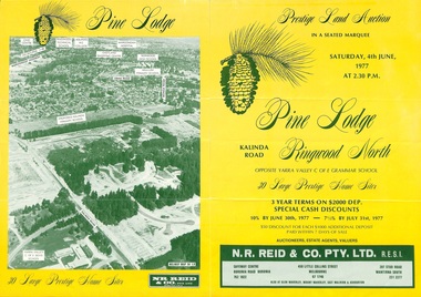
Flyer, Land Auction Sale Brochure, Pine Lodge, Ringwood North, Victoria - 1977
... Land Auction Sale Brochure, Pine Lodge, Ringwood North..., at 2:30pm. Land Auction Sale Brochure, Pine Lodge, Ringwood ...Refer also to Reg. No. 5172 for Pine Lodge Land Auction 3rd release, 1978.Yellow double-sided real estate auction notice with green print showing aerial photograph and map of subdivision layout and summary of local features and services for Pine Lodge, Kalinda Road, Ringwood North. Auction date, Saturday, 4th June, 1977, at 2:30pm.Subdivision plan includes Parkgate Drive, Wood-Church Close, and Pensby Court. (Agent) N.R. Reid & Co. Pty. Ltd., Safeway Centre, Boronia Road, Boronia (Phone) 762 1022, 450 Little Collins Street, Melbourne (Phone) 67 1746, and 207 Stud Road, Wantirna South (Phone) 231 2277. -
 Ringwood and District Historical Society
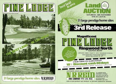
Flyer, Land Auction Sale Brochure, Pine Lodge, Ringwood North, Victoria - 3rd Release 1978
... Land Auction Sale Brochure, Pine Lodge, Ringwood North..., 18th November, 1978, at 2:30pm. Land Auction Sale Brochure ...Refer also to Reg. No. 5171 for Pine Lodge Land Auction previous release, 1977.Green tri-fold advertisement for auction of home sites, with map of subdivision, photographs, and summary of local features and services for Pine Lodge, Kalinda Road, Ringwood North - 3rd release - Auction date, Saturday, 18th November, 1978, at 2:30pm.Subdivision plan includes Mundara Drive, Bidston Court, Parkgate Drive, Frodsham Road, and Bebington Close. (Agent) N.R. Reid & Co. Pty. Ltd., 10A Hewish Road, Croydon (Phone) 725 0999, 450 Little Collins Street, Melbourne (Phone) 67 1746, and 207 Stud Road, Wantirna South (Phone) 221 2222. -
 Ringwood and District Historical Society
Flyer, Land Auction Sale Brochure, Proclamation Estate, Ringwood, Victoria - circa 1963
... Land Auction Sale Brochure, Proclamation Estate, Ringwood..., Saturday, March 2, (1963?), at 2pm. Land Auction Sale Brochure ...Land sale auction advertisement - Proclamation Estate, Ringwood, with map of subdivision and summary of local features and services. Auction date, Saturday, March 2, (1963?), at 2pm.Subdivision plan includes Maidstone Street, Stanhope Court, Wrights Court, and Watirna Road. (Agents) Blackburn & Lockwood in conjunction with C.E. Carter & Son, 126 Whitehorse Road, Ringwood (Phone) 87 6024. -
 Ringwood and District Historical Society
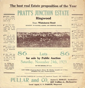
Flyer, Brochure for Land Sale By Public Auction, Pratt's Junction Estate, Ringwood, Victoria - 1923
... Brochure for Land Sale By Public Auction, Pratt's Junction... and summary of local features and services. Brochure for Land Sale ...Folded double-sided brochure advertising 86 residential lots for sale by Public Auction at 3pm, Saturday, November 24th, 1923, with town photographs, map of subdivision and summary of local features and services. Subdivision plan includes Whitehorse Road, Oliver Street, Georges Road, Junction Street, and six room weatherboard villa for sale. Local Agent - F.V. Parker, Ringwood. -
 Ringwood and District Historical Society
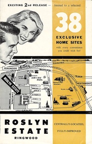
Flyer, Land Sale Brochure - Roslyn Estate, Ringwood, Vic. - circa 1960s
... Land Sale Brochure - Roslyn Estate, Ringwood, Vic. - circa... of local facilities and services. Land Sale Brochure - Roslyn ...Land sale advertisement for 2nd release of residential sites with area map, layout of the estate, terms of sale, and summary of local facilities and services.Subdivision includes Daisy Street, Vale Street, Joan Court, Christine Court, and Westmore Drive. (Agent) Heathmont Estate Agency, 103 Canterbury Road, Heathmont. (Phone) WU7808-9. Brochure also includes map with streets marked as "Sold" - Reilly Street, Adrian Court, Daisy Street, Jarma Road, Joel Court, and Ross Court, with comment that "all home sites in the first release have already been sold, and most built on." -
 Ringwood and District Historical Society
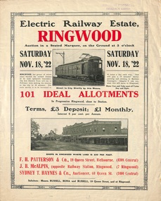
Flyer, Land Sale Auction Brochure, Electric Railway Estate, Ringwood, Vic. - 1922
... Land Sale Auction Brochure, Electric Railway Estate... of subdivision features and local facilities. Land Sale Auction Brochure ...Bi-folded single sheet with black and red print both sides advertising auction of allotments on Saturday, November 18, 1922, including details of subdivision features and local facilities. Subdivision includes Bedford Road, Williams Grove, Campbell Street, Myrtle Avenue, George Street, and Henry Street. Agents - F.H. Patterson & Co., 19 Queen Street, Melbourne, Tel. 4308 Central, J.B. McAlpin, Opposite Railway Station, Ringwood, Tel 7 Ringwood, SYDNEY T. Haynes & Co., Auctioneer, 60 Queen Street, Melbourne, Tel 3400 Central. -
 Ringwood and District Historical Society
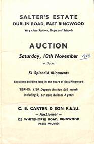
Flyer, Land Sale Auction Brochure, Salter's Estate, East Ringwood, Vic. - 1956
... Land Sale Auction Brochure, Salter's Estate, East Ringwood... layout of subdivision and terms of sale. Land Sale Auction ...Folded single page advertising auction of allotments on Saturday, 10th November (1956), including layout of subdivision and terms of sale.Subdivision includes Railway Avenue, Nicholson Street, Althol Grove (later Morcom Avenue), Illoura Avenue, Tweed Street, Merry Street, and Dublin Road. (Agent) C.E. Carter & Son R.E.S.I., Auctioneer, 126 Whitehorse Road, Ringwood, Phone WU6024. -
 Ringwood and District Historical Society
Flyer, Land Auction Advertisement adjoining Jubilee Park, Ringwood, Victoria - 1956
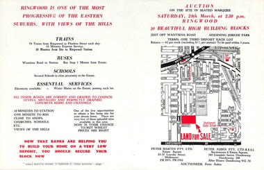
... Folded double-sided brochure advertising residential land... 932, 70. Folded double-sided brochure advertising residential ...Folded double-sided brochure advertising residential land sale auction on Saturday 24th March (1956), with locality map and subdivision layout, terms of sale, and summary of local features and services. Subdivision includes Reilly Street Ringwood, and Philip Street, Daisy Street, and Lorienne Street Heathmont. Surveyors - Messrs Little and Brosnan. Agents in Conjunction - Peter Martin Pty. Ltd., Estate Agents, 55-57 Latrobe Street, Melbourne (Phone) FB 3571, FB 2783, and Peter Aubin Pty. Ltd. R.E.S.I., Auctioneers & Estate Agents, 345 Lonsdale Street, Dandenong (Phone) Dandenong 340, After Hours, Dandenong 932, 70. -
 Ringwood and District Historical Society
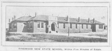
Photograph, Ringwood State School, Land sale brochure image - November, 1923
... Ringwood State School, Land sale brochure image - November... State School, Land sale brochure image - November, 1923 ...The same photo 2094b also appear in the Real Estate and Home Journal 15 January 1925 P17. -
 Ringwood and District Historical Society
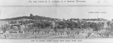
Photograph, Image used for land auction promotion of Garden Homes Estate between Mullum Mullum Road, Ringwood and Mullum Mullum Creek - 20/10/1923 , later developed to include The Centreway, Wattle Crescent, and Reserve Crescent, Ringwood
Black and white photograph of picture from subdivisional brochure. Picture shows orchard in foreground with a hill towards background. Treed area in the middle with a few houses scattered amongst them. To right of picture is printed, "Garden Homes Estate" with an arrow pointing to land. Printed above picture, "On the Land at 3 o'clock in a Seated Marquee. Typed below picture, "View of Gard -
 Ringwood and District Historical Society
Photograph, Land sale brochure map of Ringwood's early main central area around Mount Dandenong Road - c.1880s
... Land sale brochure map of Ringwood's early main central... of Ringwood East'. Land sale brochure map of Ringwood's early main ...Catalogue card reads, 'Map of Ringwood East'. -
 Ringwood and District Historical Society
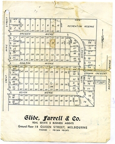
Document, Glen Turnbull, Land Sale Brochure - Heathmont Hills Estate - subdivision of Stan Wieland's Land (undated), 25/2/2008
... Land Sale Brochure - Heathmont Hills Estate - subdivision... Avenue. Land Sale Brochure - Heathmont Hills Estate - subdivision ...Small brochure by Glide Farrell & Co, real estate and Business Agents, Melbourne advertising "93 Superb Building Blocks 3Mins Station & Shops", and "Sky-Line Views of Heathmont Hills Estate" , comprising lots in Dresden Ave, Doulton Ave, Devon Ave, Viviana Crescent, Leoni Avenue. -
City of Moorabbin Historical Society (Operating the Box Cottage Museum)
Document, leaflet Box Cottage Museum, Bambra Press Ltd, 2019
Reprint 2019 by Bambra Press Ltd; Original Print 2016 This Leaflet / Brochure was compiled by City of Moorabbin Historical Society members Carol Poole, Joan Moore, Fran Bader for distribution to visitors, schools, libraries and local community to promote knowledge of Box Cottage Museum and the early settlement in the Moorabbin area. Glen Eira City Council Community Grant 2016 was obtained to finance printing by MKR Printing Ltd. Carnegie. Topics Box Cottage Museum, City of Moorabbin Historical Society, 1918 Chinese silk wedding dress, contact details, map, Box Family, Rietman Family, Land tenure records, Henry Dendy Special Survey 1841Reprint 2019, Original print 2016 Leaflet/Brochure compiled by CMHS members for distribution to visitors, schools, local community to promote knowledge of Box Cottage Museum and early settlement in the Moorabbin area1 x A4 glossy, colour, printed on both sides with photographsPage 1 BOX COTTAGE MUSEUM Page 2 William & Elizabeth Box, Land, August Rietman & Familycity of moorabbin, brighton, dendy henry, box william, box elizabeth, rietman august, rietman frieda, box cottage museum ormond, box alonzo, glen eira city council, city of moorabbin historical society, ormond, bentleigh, cheltenham, bambra press ltd port melbourne, -
 City of Moorabbin Historical Society (Operating the Box Cottage Museum)
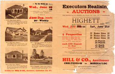
Flyer - Executors Realising Auction for land in Highett, 1941
The Great Depression of Australia halted the sale of land in most circumstances - this sale was just after the end of the depression years of 1930 to 1939.Example of the progress of the Municipality of MoorabbinAdvertising flyer for auction of real estate sales - plan of building blocks for saleSale of land in Highett - Hill & Co (A. W. Hill, Auctioneer) - brochure has pictures of the houses on the properties being offered for saleviola crescent, wickham road, henry street, real estate, highett, moorabbin, auctions, benjamin lowden -
 City of Moorabbin Historical Society (Operating the Box Cottage Museum)
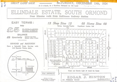
Flyer - Ellindale Estate, South Ormond, 1924
The train line from the city to Frankston was electrified in 1922 which intensified the sale in the municipality of Moorabbin, particularly land which was in the vicinity of the railway stations.Example of the progress of the Municipality of MoorabbinAdvertising flyer for auction of real estate sales - plan of building blocks for salePhotocopy of advertising brochure and two photocopies of advertisements for the auction of Ellindale Estate, South Ormond on 13 December 1924 consisting of 12 shop sites and 68 home sitesjasper road, swindon grove, creswick grove, wembley grove, ellindale ave, ormond, mckinnon, real estate, auction -
 Bendigo Historical Society Inc.
Document - DEBORAH REEF PROJECT ENVIRONMENT EFFECTS STATEMENT
Two page document. On top, first page ' Bendigo Mining N.L., Deborah Reef Project, Environment Effects Statement, Summary Brochure'. Poppet head on top LH corner of document. A map of central Bendigo is drawn on page 1 and shows the location of the proposed processing plant near the Airport. Further maps on page 2 and 3 show the North Deborah Mine Site, the pipeline route and the airfield site. The summary brochure provides an outline of the material contained in the Environment Effects Statement and proposed planning scheme amendments upon which, the Deborah Reef Project will be assessed. Page four lists the issues that impact on this submission: planning and land use; socio economic environment; traffic; discharges to air; water management; explosives storage and handling; subsidence; heritage; flora and fauna and landscape and visual assessment. The 16th March, 1989, is the date given for submissions to be lodged in regard to this project.Bendigo Mining N.Lbendigo, mining, deborah reef project -
Port Melbourne Historical & Preservation Society
Pamphlet, Ewan Ogilvy's Bayside Papers, Box Three - Beacon Cove - A Future for Princes Pier, 1990s
Ewan OGILVY, former Melbourne Councillor and also of Community Services Victoria, Inner Urban Ministerial Advisory Committee and Uniting Church's Centre for Urban Research and Action (CURA), was instrumental in social justice approaches to town planning. He and CURA's Social Justice and the City Project funded Port Melbourne community groups protesting against the SCDC development in 1987. His files were presented to the Society in May 2001 on his preparation for leaving Victoria.From Ewan OGILVY's chronologically organised 'Bayside Papers' relating to the proposed development of Port Melbourne industrial land in the late 1980s: 'Beacon Cove - A Future for Princes Pier' - promotional brochure for development of Princes Pier (Mirvac Beacon Cove Stage 2)Signed 'Ewan Ogilvy'town planning, town planning - proposals shelved - bayside, environmental issues, ewan ogilvy, mirvac