Showing 811 items
matching maps and sections
-
 University of Melbourne, Burnley Campus Archives
Plan - Photocopy, Sunshine Planning Scheme, 1993
Photocopies. 18.02.1993. (1) 5 copies Map User Guide - Sunshine Planning Scheme. List of Zones, Reservations and additional Planning Controls. (2) Sunshine Planning Scheme - Local Section. Zones and Reserved Land Map No 2. (3) Map No 3. (4) Map No 4. Used in planning Native Garden Woodlandsunshine, reservations, native garden, planning scheme, victoria department of planning and development -
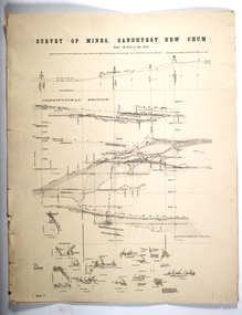 Bendigo Historical Society Inc.
Map - SURVEY OF MINES, SANDHURST, NEW CHUM, Circa 1881
Map: Survey of Mines, Sandhurst, New Chum, Longtitudinal Section of the New Chum, reef. 2 sheets. Sheet 5 and Sheet 8map, mining plan, survey of mines , sandhurst, new chum, gold mines bendigo -
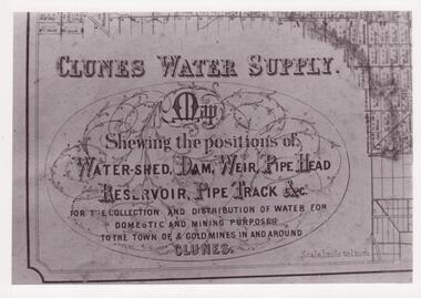 Clunes Museum
Document - MAP
CLUNES WATER SHED SUPPLY MAP SHEWING THE POSITION OF WATERSHED ECT. FOR THE COLLECTION AND DISTRIBUTION OF WATER FOR DOMESTIC AND MINING PURPOSES TO THE TOWN OF & GOLDMINES IN AND AROUND CLUNES.PHOTOCOPY SECTION OF PHOTOGRAPH AND PLAQUE AND MAP OF CLUNES WATER SUPPLY. SHOWING THE POSITION OF WATERSHED, DAM, WEIR PIPEHEAD RESERVOIR PIPE TRACK.SEE PHOTOGRAPH ON BACK OF HISTORY OF OBJECT.local history, photographs, water supply -
 National Vietnam Veterans Museum (NVVM)
Map, Long Tan Original Battle Map
Original topographical map of Long Tan area showing operational marking in black pen. Areas 1-4 marked 5RAR section.This map is the original map from 1 ATF HQ on the day of the Battle of Long Tan, 18th August, 1966.battle of long tan, map -
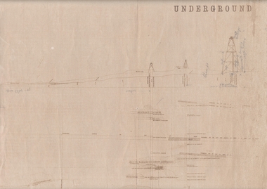 Bendigo Historical Society Inc.
Map - UNDERGROUND SECTION OF 3 MINES
Underground section of three mines - Shaft No 94, New Chum United Co, Cross Section No 89 - Shaft No 93, Lansell's 222 (DENIS), Cross Section No 87 - Shaft No 92A (New Shaft), Lansell's 222, Cross Section No 86. Map shows depth of cross sections below the sill and stone encountered. Poppet legs are drawn at the top of the shafts. Lansell's 222 Shaft No 92A has measurements penciled in.mining, parish map, new chum united, lansell's 222 -
 Bendigo Military Museum
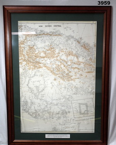
Map - MAP, NEW GUINEA FRAMED, C. 1941 onwards
Map of central section of New Guinea. Black print on white background with mountain ridges in tan. Map is mounted with green border. Brown wooden frame, glass front, white cardboard backing with wire hanging strap on back. Map prepared under the direction of RAAF Headquarters.Printed in black top centre: “NEW GUINEA CENTRAL” Printed on border under map: “These escape maps were carried in the zip pocket of life jackets by fighter pilots in WW2. This map was presented to A.S.R. on 12.7.79 by Councillor Ian McKenzie, Mayor of Eaglehawk, who served as a fighter pilot in 78th SDN in the SW Pacific area during 1943-44.”map, new guinea, central, raaf -
 Bendigo Military Museum
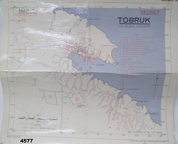
Map - MAP of TOBRUK HARBOUR, 48 Survey Coy S.A.E.C, C.1942
... maps ...Item in the Doug Dean 2nd AIF collection, refer cat No 4575PMap, laminated, “MAP T/1 SECRET TOBRUK”, shows Tobruk area and harbour, shows creeks, gullies, there are 20 marked installations in red, a rectangular section has been hand drawn on marked “E” & “F”,.At bottom RH corner, “HQ, RAF, ME, A1, 16 JULY 1942”tobruk, maps, ww2 -
 Whitehorse Historical Society Inc.
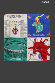
Souvenir - Handkerchief, 1956
Lawn Handkerchief - Memento of Melbourne 1956 Olympic Games. In 4 sections: (1) Map of Melbourne, (2) Picture of Melbourne Cricket Ground, (3) List of Events and Venues, (4) Map of Australia, Olympic flame and kangaroosOlympic Games 22 Nov - 8 Dec 1956civic mementoes, souvenirs -
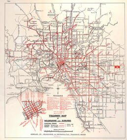
 Melbourne Tram Museum
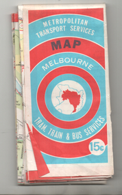
Map, Ministry of Transport, "Melbourne Transport Services Map - Tram, Train and Bus Services", c1974
Fold out map (27 sections 9 across x 3 deep), coloured of Melbourne's Tram and Bus routes, route numbers, rail lines, detailed for the central part of Melbourne and insert section for Frankston. On rear description of routes, private bus routes and map of Melbourne metro lines. Has contact details for bookings and lost property etc. Priced 15c Inscription dates the map as 1974. Two copies held.On front cover in ink "#3" in top right hand corner and "4 G 33 1974" along bottom edge of the first copy.trams, tramways, melbourne, map, tram & bus services, railways, mmtb, minister for transport -
 Bendigo Military Museum
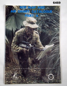
Document - ADF Map and Air Chart Catalogue Part A, RASvy Corps, May 1991
This document contains the "map and Air Chart Demand and Issue Voucher" to enable the ordering of map products. The catalogue of available products is shown on the reverse side to assist in the ordering process.1. A Map sheet of Australia folded to A4 in size. 2. A selection of map examples and a catalogue of products, Tactical Line Maps (TLM) at 1:50,000 scale to Digital Chart of the World (DCW) at 1:1,000,000 scale maps. The names of all the 1:100,000 maps are listed in alphabetical order. 3. The Map and Air Chart Demand and Issue Voucher is printed on the back of the document. 4. Front section has a photo of a soldier with a Steyr rifle kneeling reading a map.royal australian survey corps, rasvy, fortuna, army survey regiment, army svy regt, asr -
 Ringwood and District Historical Society
Map, Commonwealth Department of Defence, Military Survey map of Ringwood, 1916, Jun-16
Map prepared by Commonwealth Section Imperial General Staff given to Ringwood Historical SocietyMilitary Survey map of Ringwood +Additional Keywords: Hutchins,LL.Hutchins, 16 King's Rd. Marysville 3779. Received by postpak -
 Bendigo Military Museum
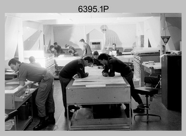
Photograph - Army Survey Regiment – Map Production, Fortuna, Bendigo, 1986
These 17 photographs of the Army Survey Regiment’s map production and facilities were taken at Fortuna Villa, Bendigo, April 1986. Photos .1P to .3P were taken in Cartographic Squadron’s Correcting Section in the Attic. located on the top floor of Fortuna Photos .4P to .5P were taken in Cartographic Squadron’s Proving Section, located in the Ballroom also on the top floor facing the lake. The technicians were probably involved in a rapid response map production, as they all were wearing field uniforms. As ‘Regiment Overcrowding’ is annotated on the plastic sleeve holding the negatives, it seems the photos were taken when the unit was at its capacity to demonstrate the lack of suitable work areas. The Army Survey Regiment’s Duty Room, RAP and Carpark appearing in Photo .10P was probably taken from the top steps near the SGT’s accommodation block. Two of the photos in this set are also published in item 6096.5P.This is a set of 17 photograph of Map Production and car park was taken at the Army Survey Regiment, Fortuna, Bendigo, in April 1986. The black & white photographs are on 35mm negative film and are part of the Army Survey Regiment’s Collection. The photographs were scanned at 96 dpi. .1) - Photo, black & white, 1986. Correcting Section, Attic: L to R: CPL Andy Lucas, SPR Chris Gordon, unidentified, SPR Jan (Crighton) Minchin, CPL Robin Marshall, CPL Frank Downie, SPR Gayle Humphrey, unidentified (x2), Jason Wells at rear. .2) - Photo, black & white, 1986. Correcting Section, Attic: L to R: CPL Andy Lucas, SPR Chris Gordon, unidentified, SPR Jan (Crighton) Minchin, CPL Robin Marshall, CPL Frank Downie, SPR Gayle Humphrey, unidentified, Jason Wells, unidentified. .3) - Photo, black & white, 1986. Correcting Section, Attic: L to R: CPL Andy Lucas, CPL Robin Marshall, SPR Chris Gordon, unidentified, CPL Frank Downie, SPR Gayle Humphrey, unidentified, SPR Jan (Crighton) Minchin at rear., Jason Wells on phone. .4) & .5) - Photo, black & white, 1986. Proving Section, Ballroom: On left front to back: SGT Alan Staley, SGT Roger Rees, SGT Greg Anderson. On right front to back: SGT Denis McCarthy, SGT Tim Allanson, SSGT Adrian ‘Charlie’ Creedy. .6) - Photo, black & white, 1986. Records & Proofing buildings. .7) - Photo, black & white, 1986. Technical Services temporary buildings. .8) - Photo, black & white, 1986. Q-store and transport buildings. .9) - Photo, black & white, 1986. Technical Services temporary buildings in front of transport compound. .10) - Photo, black & white, 1986. Army Survey Regiment Duty Room, RAP and Carpark at Fortuna. .11) - Photo, black & white, 1986. Records & Proofing buildings. .12) - Photo, black & white, 1986. Other Ranks (OR’s) car park and barracks with kitchen in background. .13) - Photo, black & white, 1986. Other Ranks kitchen, parade ground and SGT’s/Officers barracks in background. .14) - Photo, black & white, 1986. Fortuna Villa taken from the steps near the SGT’s accommodation block. .15) - Photo, black & white, 1986. Fortuna Villa taken from the steps near the OR’s s accommodation block. .16) - Photo, black & white, 1986. Fortuna Villa taken from the roadway near the OR’s accommodation block. .17) - Photo, black & white, 1986. 20’ x 30’ Army tents set up on the basketball court..1P to .17P – ‘Regiment Overcrowding’ and the date are annotated on the plastic sleeve.royal australian survey corps, rasvy, army survey regiment, army svy regt, fortuna, asr -
 Kew Historical Society Inc
Map, Osboldstone & Co Pty Ltd, Railway and Tramway Map of Melbourne and Suburbs With Tram Timetables, 1917
The Railway and Tramway Map of Melbourne and Suburbs With Tram Timetables lists existing Cable Tram Services before the entire network was electrified. By 1917 the tramways system was divided into regions including: the Melbourne Cable Tram Service; Prahran - Malvern Electric Trams; Hawthorn Electric Trams; Melbourne, Brunswick and Coburg Electric Trams; and Brighton Beach Electric Trams. The old Outer Circle railway line is marked as ending in Deepdene, with the remainder of the line to Fairfield marked as 'Unused'. The Kew tram along High Street in 1917 ended at the Harp Junction. The Kew Spur Line is also marked on the map.The Railway and Tramway Map of Melbourne and Suburbs With Tram Timetables is historically significant as it captures at a point in time, 1917, the development of public transport infrastructure in Melbourne. As such it illustrrates the theme: Connecting Victorians by transport and communications.Printed card-covered pocket sized map that folds out with three horizontal and vertical folds. Colour map, with scale, of the rail and tram networks on one side and sixteen sections of black and white printed text and timetable information on the reverse.railway maps -- melbourne (vic.), tramways maps -- melbourne (vic.), public transport -- melbourne (vic.) -- 1910-1920, cartography -
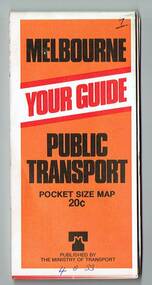
 Melbourne Tram Museum
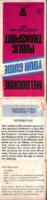
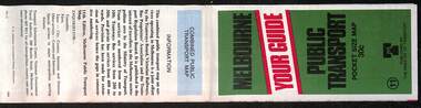
Document, Ministry of Transport, Melbourne Public Transport Map - No. 12, 1982
Map No. 12 - Includes description of tram and bus routes, private bus routes. On the front cover is composite image of Melbourne public transport vehicles. Has contact details for bookings and lost property etc and how to use the map. Priced at 40c, issue No. 12 of c1982. Has details of the then new Travelcard ticket system. Yields information about Melbourne public transport services in 1982.Fold out map (36 sections 9 across x 4 deep), "Public Transport Map", coloured of Melbourne's Tram and Bus routes, route numbers, rail lines, detailed for the central part of Melbourne and the outer Metropolitan services.tramways, melbourne, tram services, bus services, railways, travelcard -
 Melbourne Tram Museum
Map, Ministry of Transport, Melbourne Public Transport Map - No. 9, 1979
... maps ...Map No. 9 - Includes description of tram and bus routes, private bus routes. Has contact details for bookings and lost property etc and how to use the map. Yields information about Melbourne public transport services in 1979Fold out map (27 sections 9 across x 3 deep), "Public Transport Map", coloured of Melbourne's Tram and Bus routes, route numbers, rail lines, detailed for the central part of Melbourne and the outer Metropolitan services.tramways, melbourne, tram services, bus services, railways, travelcard, maps -
 Melbourne Tram Museum
Map, Ministry of Transport, Melbourne Public Transport Map - No. 11, 1980
... maps ...Map No. 11 dated on rear as 1980 - Includes description of tram and bus routes, private bus routes. Has contact details for bookings and lost property etc and how to use the map. Yields information about Melbourne public transport services in 1980Fold out map (27 sections 9 across x 3 deep), "Public Transport Map", coloured of Melbourne's Tram and Bus routes, route numbers, rail lines, detailed for the central part of Melbourne and the outer Metropolitan services.tramways, melbourne, tram services, bus services, railways, maps -
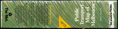
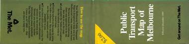
 Melbourne Tram Museum
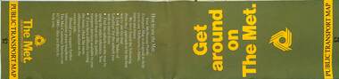
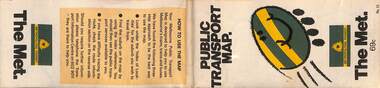
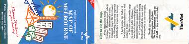
Map, The Met, Public Transport Map - Get around on The Met, c1987
... maps ...Undated map - c1987 - Neighbourhood and travelcard tickets, has a photo of the front of B2 2004, includes a map of the travelcard neighbourhoods, commuter passes and The Met contact details.Yields information about Melbourne public transport services in c1987Fold out map (36 sections 9 across x 4 deep), "Public Transport Map", coloured of Melbourne's Tram and Bus routes, route numbers, rail lines, detailed for the central part of Melbourne and the outer Metropolitan services.tramways, melbourne, tram services, bus services, railways, maps, travelcard, neighbourhood tickets -
 Melbourne Tram Museum
Map, The Met, "Public Transport Map - No. 13", 1984
... maps ...Map No. 13 undated with the buzzing bee symbol on the front and throughout at the time of the introduction of the neighbourhoods. Includes description of tram and bus routes, private bus routes. Has contact details for bookings and lost property etc and how to use the map. Gives extensive details of the neighbourhood tickets and their used. C1984.Yields information about Melbourne public transport services in 1984.Fold out map (36 sections 9 across x 4 deep), "Public Transport Map", coloured of Melbourne's Tram and Bus routes, route numbers, rail lines, detailed for the central part of Melbourne and the outer Metropolitan services.tramways, melbourne, tram services, bus services, maps -
 Melbourne Tram Museum
Map, Public Transport Corporation (PTC), "Public Transport Map of Melbourne", 5/1995
... maps ...Map Includes description of tram and bus routes, private bus routes, and rail lines. Has contact details for bookings and lost property etc and how to use the map. Gives details of the ticketing system, along with photographs of the various modes. Dated May 1995 with a stylised image of some of Melbourne's landmarks on the cover. Published by the Public Transport Corporation.Yields information about Melbourne public transport services in 1995.Fold out map (36 sections 9 across x 4 deep), "Public Transport Map", coloured of Melbourne's Tram and Bus routes, route numbers, rail lines, detailed for the central part of Melbourne and the outer Metropolitan services.tramways, melbourne, tram services, bus services, maps, railways -
University of Melbourne, Burnley Campus Archives
Map, Photo Mapping Services Pty. Ltd, Burnley College Burnley Gardens, 1995
HistoricalMap compiled by Photo Mapping Services Pty. Ltd., using aerial photography, dated 9th July, 1995. (1) Coloured proof. Scale 1:500. Aerial views, with and without trees marked, of Burnley Gardens: (2) Map with trees (3) Map without trees, sections numbered but no legend.burnley college, gardens, trees -
Bendigo Historical Society Inc.
Document - BASIL MILLER COLLECTION: TRAM, TRAMWAY ROUTES AND SECTION DESTINATIONS, c1971?
Document. State Electricity Commission of Victoria. Electricity Supply Department - Bendigo Tramways. Tramway routes and section destinations. 15 copies of same route map.organization, business, bendigo trams -
 Melbourne Tram Museum
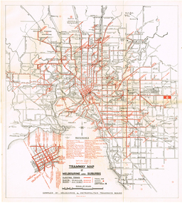
Map, "Tramway Map of Melbourne and Suburbs", c1952
Map of Melbourne's Tram and Bus routes, route destinations, MMTB Guest houses, all-night bus routes, depots, golf links and sporting grounds, rail lines, and location of major places of interest. Titled - "Tramway Map of Melbourne and Suburbs" - c1952, after the La Trobe or Latrobe St lines opened. Not known who produced the map. Does not give route numbers. See also Reg Item 2300 for an MMTB Map of the same era, 7315 for a similar version but without the guest houses, and 4525.1 for an MMTB Photograph.Yields information about Melbourne tram routes prior to Bourke St being built.Fold out map (6 sections), two colours. Has been removed from a book with the remnants of other paper in the top left-hand side.trams, tramways, melbourne, map, tram & bus services, all night services, mmtb, guest houses -
 Melbourne Tram Museum
Map, "Tramway Map of Melbourne and Suburbs", c1950
Map of Melbourne's Tram and Bus routes, route destinations, all-night bus routes, depots, golf links and sporting grounds, rail lines, and location of major places of interest. Titled - "Tramway Map of Melbourne and Suburbs" - c1950, after the La Trobe or Latrobe St lines opened. Not known who produced the map. Does not give route numbers. See also Reg Item 2300 for an MMTB Map of the same era, 3720 for a similar version with the MMTB guest houses shown, and 4525.1 for an MMTB Photograph.Yields information about Melbourne tram routes prior to Bourke St being built.Fold out map (6 sections), two colours. Has been removed from a book with the remnants of other paper in the top left-hand side.has "1950" in top left hand corner in ink.trams, tramways, melbourne, map, tram & bus services, all night services, mmtb -
Clunes Museum
Map, DEPARTMENT OF MINES, Untitled, c1859
All maps show names and locations of mines operating in the district (see reference section link to article).1 Map of Creswick Clunes - lists 45 mines in the Clunes enlargement and 100 mines in the Creswick enlargement .2 Department of Mines map of Clunes Creswick and shows the McDonald & Co. Pre-emptive area. Indexes for quartz and alluvial mine locations .3 Topographical map Ref GF23 Clunes Mt. Greenock Talbot.1 360 Scale 1:2500 .2 303/59 33 hand written in ink "received 15 October 1859" signed by R Broughton, James Stevenson - District Mining Surveyor .3 40 chains to an Inchgold mining, dept of mines -
 Melbourne Tram Museum
Map, Ministry of Transport, "Melbourne Transport Services Map - Tram, Train and Bus Services", 1977
Fold out map (27 sections 9 across x 3 deep), coloured of Melbourne's Tram and Bus routes, route numbers, rail lines, detailed for the central part of Melbourne and insert section for Frankston. On rear description of routes, private bus routes and map of Melbourne metro lines. Map No. 7, 1977. Has contact details for bookings and lost property etc. Priced 20c. 1977, route 59 showing as terminating opposite Essendon Airport.On front cover in ink "" in top right hand corner and "4 G 33 " along bottom edge.trams, tramways, melbourne, map, tram & bus services, railways, mmtb, minister for transport -
Tatura Irrigation & Wartime Camps Museum
Map, Irrigation Trust distribution channels
Map retrieved from State Rivers & Water Supply Commission Offices by Gilian Payne. Map of Rodney Irrigation Trust distribution channels, 1887, prepared by Walter Scott Murray. Copied in seven sections. -
 Melbourne Tram Museum
Map, The Met, Public Transport Map of Melbourne - Get around on The Met, 8/1989
... maps ...Melbourne transport map - dated August 1989 - zone ticket system, has a photo of the front of B2 2004, includes a map of the ticket zones, and The Met contact details.Yields information about Melbourne public transport services in August 1989.Fold out map (36 sections 9 across x 4 deep), "Public Transport Map of Melbourne", coloured of Melbourne's Tram and Bus routes, route numbers, rail lines, detailed for the central part of Melbourne and the outer Metropolitan services.tramways, melbourne, tram services, bus services, railways, maps, zones -
 Melbourne Tram Museum
Map, The Met, Public Transport Map of Melbourne - Get around on The Met, 12/1989
... maps ...Melbourne transport map - dated December 1989 - scratch ticket system, has a photo of the front of B2 2004, includes a map of the ticket zones, and The Met contact details.Yields information about Melbourne public transport services in December 1989 following the introduction of Scratch tickets.Fold out map (36 sections 9 across x 4 deep), "Public Transport Map of Melbourne", coloured of Melbourne's Tram and Bus routes, route numbers, rail lines, detailed for the central part of Melbourne and the outer Metropolitan services.tramways, melbourne, tram services, bus services, railways, maps, zones, scratch tickets -
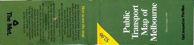 Melbourne Tram Museum
Map, The Met, Public Transport Map of Melbourne - Get around on The Met, 8/1990
... maps ...Melbourne transport map - dated August 1990 - includes a map of the ticket zones, and The Met contact details and notes where tickets can be obtained fromYields information about Melbourne public transport services in August 1990Fold out map (36 sections 9 across x 4 deep), "Public Transport Map of Melbourne", coloured of Melbourne's Tram and Bus routes, route numbers, rail lines, detailed for the central part of Melbourne and the outer Metropolitan services.tramways, melbourne, tram services, bus services, railways, maps, zones -
 Vision Australia
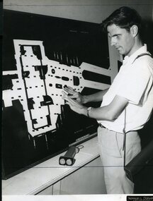
Photograph - Image, Ron Goodwin reading a map of Wynyard train station, 1969?
... Maps ...Ron Goodwin reads a tactile map of Wynyard Railway Station in Sydney's CBD. The map was made at the Sydney Tesol College with wood working machinery and painting/decorating sections. In front of Ron sits a ultrasonic torch.B/W photograph of man looking at relief map of Wynyard Station14/69051 Ann. Report Orientation - historicalroyal blind society of nsw, ron goodwin, maps