Showing 260 items
matching may price
-
 Eltham District Historical Society Inc
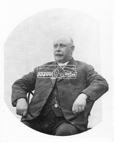
Photograph, Councillor Albert Henry Charles Price
Albert Price (1860- 1945) purchased a 31 acre block of the Montmorency subdivision. From 1911 to 1922 he was a member of the Heidelberg Shire Council and was later President of that shire. He then became the first Councillor representing Montmorency within the Shire of Eltham. He served from 1925 to 1945. He was President of the Shire five times. His achievements included bringing electric light and water into Eltham, Montmorency and Briar Hill, the improvement to the train service, together with the construction of a station at Montmorency. He was a member of the Montmorency State School committee and was also a mason. He died in May 1945 aged 85 years while still being a serving councillor. He is buried at Fawkner Cemetery. His name is remembered in the naming of Price Avenue, Montmorency. A memorial plaque was placed in the original Memorial Hall in Rattray Road in memory of Albert and Janet Price's commitment to the new suburb of Montmorency. This photo forms part of a collection of photographs gathered by the Shire of Eltham for their centenary project book, "Pioneers and Painters: 100 years of the Shire of Eltham" by Alan Marshall (1971). The collection of over 500 images is held in partnership between Eltham District Historical Society and Yarra Plenty Regional Library (Eltham Library) and is now formally known as 'The Shire of Eltham Pioneers Photograph Collection.' It is significant in being the first community sourced collection representing the places and people of the Shire's first one hundred years.Digital imagesepp, shire of eltham pioneers photograph collection, councillor price, montmorency, albert price, portrait -
 Flagstaff Hill Maritime Museum and Village
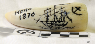
Craft - Scrimshaw, Hero 1870, Late 20th Century
Scrimshaw is regarded as early folk art and is associated primarily with whaling that was opened up in the Pacific at the end of the eighteenth century by sailors mainly from American, English and French vessels. As a result, some of the best scrimshaw from Pacific whales can be found in collections in these countries. Even though sailors must have had plenty of spare time between periods of whaling scrimshaw on whale teeth seems a rarity before the 1830s. One reason may have been the high price paid for whale teeth ivory in this period making scrimshaw on teeth popular only after the market was saturated and the price dropped. The earliest identified engraver of whale teeth is the English whaling master Captain J. S. King who was active between 1817 and 1823. There have been six ships called the Hero in the Royal Navy and this ship was the fourth named Hero, it was a screw-propelled 91-gun and second-rate. In the rating system of the British Royal Navy, this term is used to categorise sailing warships, a second-rate was a ship of the line which by the start of the 18th century mounted 90 to 98 guns on three gun decks. Earlier 17th-century second rates had fewer guns and were originally two-deckers or had only partially armed third gun decks. The Hero was launched in 1858 and sold in 1971. On July 1860 the Prince of Wales embarked onboard HMS Hero, Albert Edward Prince of Wales, was the eldest son of Queen Victoria, and the future King Edward VII, at the time he was then nineteen years of age, and on route to Newfoundland, Canada and the United States on his first state tour. He was the first member of the British royal family to visit North America. In 1860 the Queen had intended to pay a visit to Canada however stress prevented her from travelling. The then Prime Minister Lord Palmerston suggested that “Bertie” the prince of Wales could represent the Queen and on July 10th 1860, Bertie boarded HMS Hero for a tour of Canada and the USA. On July 23rd the ship arrived at Terranova. By the second week of August, the HMS Hero had sailed up the St. Lawrence River and anchored at Quebec. The Prince was successful with Canadian society visiting Quebec and Montreal during his stay. He went on to visit the United States following an invitation by President James Buchanan. His American journey was regarded as a great success. President Buchanan wrote to Queen Victoria: "He “Bertie” has faced a very difficult task for a person his age and his behaviour in all this has been that of his age and position. He has shown himself honourable, Frank and affable and he won the respect of the sensible and wise people". The scrimshaw is believed to be a modern reproduction of a typical scrimshaw scene and engraved very crudely onto a synthetic substance. Scrimshaw art carved into non-natural material in the shape of a whale tooth. The line artwork images of a three-masted, fully rigged ship and an anchor are coloured black. Inscription is engraved into tooth.Engraved "Hero 1870"warrnambool, flagstaff-hill, flagstaff-hill-maritime-museum, maritime-museum, shipwreck-coast, flagstaff-hill-maritime-village, scrimshaw, plastic, resin, replica, prince of wales, british navy vessel, whaling, hms hero, reproduction, carving, engraving -
 Federation University Historical Collection
Plan, Burrumbeep, 1884, 16/10/1884
Auctions of Crown land were introduced in the Colony of Victoria from 1851 to encourage settlers to occupy and work the land. Many squatters purchased land at auction at the upset (minimum) price of £1 per acre. In some areas where demand was high, such as the goldfields, the price realised at auction was much more. Land was put up for sale in the study area on the Burrumbeep run in May 1855, on the Lexington run in 1857, and on the Gorrinn run in 1858. (http://www.ararat.vic.gov.au/library/document/thermatics.pdf, accessed 27 January 2015) For 70 years or more, Yalla-y-Poora, Burrumbeep, Edgarley, Mount William and Narrapumelap ranked in the leading wool producers in Victoria. 1 Stud owners at Yalla-y-Poora, Eurambeen, Burrumbeep and Challicum crossed merino sheep with sheep descended from John Macarthur's Camden Park in New South Wales. (http://www.ararat.vic.gov.au/library/document/thermatics.pdf, accessed 27 January 2015) In what was to become the Ararat Mining Division, gold was discovered in May 1854 on the Burrumbeep run at a place that became known as Pinky Point on the Mount William goldfield. By 21 June 1854, between 600 and 1,000 people had arrived. (http://www.ararat.vic.gov.au/library/document/thermatics.pdf, accessed 27 January 2015)\ Town allotment plan for Burrumbeep. Merrymbuela, Borung, Lexington and Langi Logan are neighbouring areas. The plan includes the Burrumbeep Pre-Emptive Right (Roger and Wright); licensed land holders including Stephen Young, John Carroll, William Walsh, Thomas Purcell, Martha M. Bond, Colin Johnson, John Charles Webb, Henry Withycombe, William Henry Barbridge, John Wall, Thomas Flatelly, William Jenkinson, Elisia Radford, V. Radford, Denis Byrne, George Cook. Land holders included Andrew Maloney, Richard Wingfield Harrocks, W. Sporton, Terence Lynch, F. S. Falkiner, A. Millman, H. Morris, George Upham, J. McCLure, S. Fletcher, W. Parker, Thomas Myers, William wright, W.C. Winter, C. Wordman, Oliver A. Winter This plan is associated with former Ballarat School of Mines student Richard Squire (1875-6) Gift of the Squire FamilyVerso written in pencil - Plan of Burrembeep Ararat Burrembeep Araratburrumbeep, corrinn, langi logan, merrymbuela, lexington, ararat, roger & wright, cook, rogers, upham, george upham, ross, parsans, morris, johnson, withycoombe, colin johnson, falkiner, dsporton, john carroll, donald gordon, denis bryne, maurice dooley, martha bond, william harricks, \william wingfield harricks, william l.c. harricks, michael houlihan, thomas purcell, martin ryan, michael cody, fletcher, mccaw, w. parker, j.m. clow, elisia radford, thomas radford, thomas myers, barbridge, e. wilde, j. wall, flatelly, g. wardman, w.c. winter, david ball, jenkinson, ballarat school of mines, richard squire, squire -
 Flagstaff Hill Maritime Museum and Village
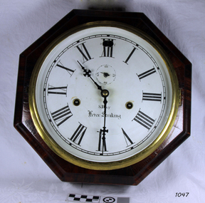
Clock, 1867-1870
Chauncey Jerome (1793–1868) was an American clock maker in the early to mid 19th century. He made a fortune selling his clocks, and his business grew quickly. Jerome was born in Canaan USA in 1793 son of a blacksmith and nail-maker. He began his career in Plymouth, making dials for long-case clocks where he learned all he could about clocks, particularly clock cases, and then went to New Jersey to make seven-foot cases for clocks mechanisms. In 1816 he went to work for Eli Terry making "Patent Shelf Clocks," learning how to make previously handmade cases using machinery. Deciding to go into business for himself, Jerome began to make cases, trading them to Terry for wooden movements. In 1822 Jerome moved his business to Bristol New Haven, opening a small shop with his brother Noble and began to produce a 30-hour and eight-day wooden clocks. By 1837 Jerome's company was selling more clocks than any of his competitors. A one-day wood-cased clock, which sold for six dollars had helped put the company on the map. A year later his company was selling that same clock for four dollars. The company also sold one line of clocks at a wholesale price of 75 cents and by 1841 the company was showing an annual profit of a whopping $35,000, primarily from the sale of its brass movements. In 1842 Jerome moved his clock-case manufacturing operation to St. John Street in New Haven. Three years later, following a fire that destroyed the Bristol plant, Jerome relocated the entire operation to Elm City factory. Enlarging the plant, the company soon became the largest industrial employer in the city, producing 150,000 clocks annually. In 1850 Jerome formed the Jerome Manufacturing Co. as a joint-stock company with Benedict & Burnham, brass manufacturers of Waterbury. In 1853 the company then became known as the New Haven Clock Co, producing 444,000 clocks and timepieces annually, then the largest clock maker in the world. Jerome's future should have been secure but in 1855 he bought out a failed Bridgeport clock company controlled by P.T. Barnum, which wiped him out financially, leaving the Jerome Manufacturing Co. bankrupt. Jerome never recovered from the loss. By his admission, he was a better inventor than a businessman. When Jerome went bankrupt in 1856 the New Haven Clock Company purchased the company. One of the primary benefits of Jerome purchasing New Haven in the first place was the good reputation of the Jerome brand and the network of companies that remained interested in selling its clocks. In England, Jerome & Co. Ltd. sold Jerome clocks for the New Haven company until 1904, when New Haven purchased the English firm outright. After his involvement with the New Haven Company in 1856, Jerome traveled from town to town, taking jobs where he could, often working for clock companies that had learned the business of clock making using Jerome's inventions. On returning to New Haven near the end of his life, he died, penniless, in 1868 at the age of 74. The company struggled on after Jerome's bankruptcy until after World War II, when the company endeavored to continue through disruptions caused by a takeover along with poor sales, finally having to fold its operations in 1960 a little more than 100 years after it had been founded. The item is significant as it is associated with Chauncey Jerome who had made a historic contribution to the clock making industry during the 19th century when he began to substitute brass mechanisms for wooden mechanisms in his clocks. This was said to be the greatest and most far-reaching contribution to the clock industry. Because of his discovery of stamping out clockwork gears rather than using castings, Jerome was producing the lowest-priced clocks in the world. That can only add to his significance as the major clock manufacture of the 19th century. Jerome may have made and lost, a fortune selling his clocks but was perhaps the most influential and creative person associated with the American clock business during the mid-19th century. Also, he had served his community as a legislator in 1834, a Presidential elector in 1852 and mayor of New Haven, Connecticut from 1854 to 1855.Clock, marine, in octagonal rosewood veneer case. Roman numerals to dial, has a seconds dial. 2 key-winding holes slow-to-Fast adjustment pin through dial. Small lever in lower edge of case activates a chime. "8 day, 8 inch, Lever Striking escarpment " Paper label on the back of the clock "Jerome & Co, New Haven, Conn" "Manufacturers of every variety of Office and Home Clocks and Time Pieces".flagstaff hill, warrnambool, shipwrecked-coast, flagstaff-hill, flagstaff-hill-maritime-museum, maritime-museum, shipwreck-coast, flagstaff-hill-maritime-village, clock, jerome & co, new haven, clock maker, chauncey jerome -
 Federation University Historical Collection
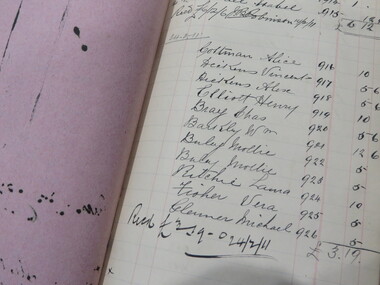
Book - Ledger, Ballarat Technical Arts School Student Fees Ledger, 1907-1914, 1907-1914
The Ballarat Technical Art School opened in 1907 as a division of the Ballarat School of Mines.Ledger with brown and blue marbled paper cover and brown tape spine. Some names are listed under keywords.ballarat technical art school, h.w. malin, lilliam moyle, queens college, .doris walker, emily turnbull, viola jackson, c.w. sergeant, hilda wardell, hettie gilbert, alice benoit, ella morrow, d.g. johnston, p. brokenshire, edna tweedie, millicent white, dorisn walker, isla gray, mollie brophy, annie speak, c.v. clegg, agnes w. reid, nin z. woinarski, bessie yates, bessie landles, jean mcdonald, harold herbert, harold h. herbert, lizzie develin, florrie sides, fletcher j. crane, catherine ronald, gertrude owen, m.d. hamilton, clara v. clegg, leslie sim, ida barker, charlotte turner, florrie barnes, james n. boyce, leo coburn, carrie peters, mabel chapman, fred mcintyre, elsie rich, henry c. hart, g. bannerman, jack meadows, preston white, lyn hamilton, a. murray, lillian moyle, nina davies, maggie kittelty, m. snell, samuel mee, agnes carley, ida delina, katherine dillon, nellie mccubbin, lila lynch, e. owen, g. owen, d. owen, alice m. coltman, ruby bawden, elsie joy, ellen j. norton, herbert rich, g. medwell, maria loader, agnes gibb, quennie young, a.e. kennedy, o. geddes, ruby l. smith, roy proctor, elsie naples, w.b.g. mcdonald, cecil brittain, elsie fawcett, g. calvert, albert coates, catherine hogan, may vercoe, daisy saunders, dora furness, matilda johnson, gordon steele, c.w. sargeant, e. cornell, irene hewitt, wilie finn, clare clegg, jessie mccallum, c.f. white, e. kilsall, kate morris, ella garrett, winnie trompf, ellie mckissock, oswald gedded, doris walker, elsie tipping, rose smith, daisy lewellin, eliza frank, una e. fitts, may wasley, grace medwell, mollie laffey, a. duck, pearl sergent, e. penny, r. bieske, f. pattendon, e.g. bailymay booth, nelliw evans, gertie evans, e. baker, c. brittain, ralph leyland, e. tipping, mary sheehan, may chenery, j. bickart, e. perry, m. bessemeres, george richardson, f. mcintyre, h. fern, d. little, o. tolputt, arthur toop, p. lakeland, charles j. rawlings, jack hooly, thomas pattenden, elsie finch, ernest murfett, gordone steele, frank power, n.j. coote, william ewart, patrick ryan, david walker, john perry, vera lindsay, robert cooper, violet leadbeater, maggie skelton, clara mann, laura ritchie, james m. johnston, ida brown, ethel butcher, michael glenane, f.j. branigan, keith booth, henry elliot, reg cutter, stan westcott, frank king, lottie finch, ladies art association, pauline lakeland, cyril thermeyer, albert berryman, stanley lindsay, joseph bickart, alf berryman, leo hewitt, hilda tweedie, vera carroll, lionel davies, isabel kiel, alex dickens, henry elliott, mollie buley, meg moore, harrie fern, eileen conway, minnie buchanan, thomas price, edward stewart, joy lugg, olive grainger, m. heinz, d. gooch, p. moon, g. bailey, charles bray, daisy dickman, george calvert, florence sides, tom hannah, eileen blake, ethel benoit, ruby oaff, chrissie ware, harrie wilson, muriel cornel, phoebe wilkinson, fanny kay, john norcott, stewart o'loughlan, m. featherstone, f. tweedie, a. corbould, d. allanby, f. buchanan, l. cody, v. fisher, r. murphy, hilda jamieson, bessie eason, phyllis palmer, lila hall, vera hall, anie walton, ruby stevens, dorotthy davison, ethel hancock, anas ross, lizzie williams, lional davies, leslie page, frank page, lilian bell, may henry, doreen mclean, dorothy dobson, helen mcintosh, charles fraser, murial cornell, j.b. sutcliffe, dorothy dawson, emma mavin, agnes lumsden, virginia kerr, emily figgis, beryl craddock, winnie treloar, gladstone procter, f.w. procter, effie baker -
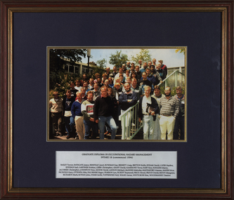 Federation University Historical Collection
Photograph - Colour, Graduate Diploma in Occupational Hazard Management - Intake 18, 1994, 1994
Victorian Institute of Occupational Safety and Health (VIOSH) Australia is the Asia-Pacific centre for teaching and research in occupational health and safety (OHS) and is known as one of Australia's leaders on the field. VIOSH has a global reputation for its innovative approach within the field of OHS management. VIOSH had its first intake of students in 1979. At that time the Institution was known as the Ballarat College of Advanced Education. In 1990 it became known as Ballarat University College, then in 1994 as University of Ballarat. It was 2014 that it became Federation University. VIOSH Australia students are safety managers, senior advisors and experienced OHS professionals. They come from all over Australia and industry. Students are taught active research and enquiry; rather than textbook learning and a one-size fits all approach. VIOSH accepts people into the Graduate Diploma of Occupational Hazard Management who have no undergraduate degree - on the basis of extensive work experience and knowledge. Timber framed colour photograph of thirty seven people with name plate at the bottom.Typed name plate with all the namesviosh, viosh australia, graduate diploma in occupational hazard management, trevor bailey, james bathgate, janet benstead, kay bowman, craig brissett, keith britton, david byham, hayden cater, earl eddings, kristine gardiner, christopher gibbs, david grant, terry hammond, ken hart, maree hodgins, christopher jacobsen, peter johnston, david kiddie, michael lawson, malcolm mcinnes, graeme maddaford, erica mayer, gary nicholls, rita ottewill, roger palubinski, lyn pearson, raymond pickett, cheryl price, davis proud, mangaiya reddy, mark richards, john rowan, keith symes, neil topperwien, gavin walsh, kim whytcross, damien woodmansey, university of ballarat -
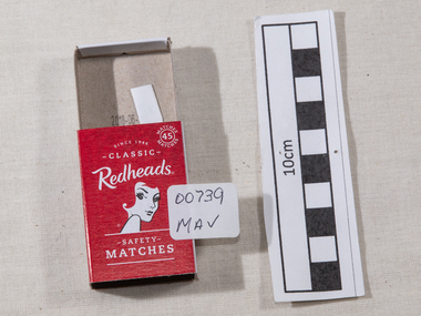 City of Moorabbin Historical Society (Operating the Box Cottage Museum)
Manufactured Objects, safety matches 'Redheads' 2015, c2015
This is a current example of the 'Redhead' logo used by Bryant & May Ltd Richmond,Victoria, Australia c 1946 - 1980 On 15th December 1909, Bryant & May, Australia’s first match factory at Church Street, Richmond, Victoria. was opened by The Honourable Alfred Deakin, Prime Minister of Australia, and Mrs. Deakin. It was heralded by the first Commonwealth Government of newly-federated Australia because the government of the day was anxious to encourage secondary industry and pledged tariff protection of local manufacturers. The building was constructed in 1909 as the Empire Works to a design by prolific Melbourne architect William Pitt and was purchased soon after by British safety match manufacturer Bryant and May, who significantly expanded the building, adding another level and the landmark clock tower. Bryant and May were unique in that they operated as a model factory, providing workers with conditions and amenities that even today seem generous. These included a dining hall and sports facilities such as a tennis court and bowling green which were constructed in the 1920s. Bryant and May ceased Australian match manufacture in the early 1980s as a result of import competition. Their iconic Redheads matches are now imported from Sweden. The complex has since been converted for use as offices and showrooms but is extremely well preserved. It is listed on the Victorian Heritage Register. Bryant and May was a United Kingdom (UK) company created in the mid-nineteenth century specifically to make matches. Their original Bryant and May Factory was located in Bow, London. They later opened other match factories in the United Kingdom and Australia, such as the Bryant and May Factory, Melbourne; and owned match factories in other parts of the world. Bryant and May survived as an independent company for over seventy years, but went through a series of mergers with other match companies and later with consumer products companies. To protect its position Bryant and May merged with or took over its rivals. In 1971 the Northern Ireland factory, Maguire & Patterson closed down following a terrorist attack.. In the 1980s, factories in Gloucester and Glasgow closed too leaving Liverpool as the last match factory in the UK, until December 1994. . The registered trade name Bryant and May still exists and it is owned by Swedish Match Industries as are many of the other registered trade names of the other, formerly independent, companies within the Bryant and May group. Two French chemists, Henri Savene and Emile David Cahen, proved in 1898 that the addition of phosphorus sesquisulfide meant that the substance was not poisonous, that it could be used in a "strike-anywhere" match, and that the match heads were not explosive. British company Albright and Wilson, was the first company to produce phosphorus sesquisulfide ( Red Phosphorous) matches commercially. The company developed a safe means of making commercial quantities of phosphorus sesquisulfide in 1899 and started selling it to match manufacturers. Matches were first produced by Bryant & May in Australia in 1909. The Redhead name applies to the red striking heads of the matches which were introduced to Australia in 1946. The logo on the matchbox depicted the head and shoulder of a redheaded woman and has had four major updates since that time with a number of special issues depicting animals, birds and notable persons also producedThe Bryant & May Ltd factory in Church St Richmond is a listed building and has been converted to apartments following the closure of the Company 1980. Bryant & May's Ltd were influential in fighting against the dreadful disease known as Phossy jaw which was caused by white phosphorus used in the manufacture of the early matches. They were also the object of the 'Match Girls Strike' in London 1888, which won important improvements in working conditions and pay for the mostly female workforce working with the dangerous white phosphorus. The public were slow to purchase these safety matches because of the higher price An empty box of 'Redheads' safety matches made in Sweden for ST-Group, Springvale, Victoria, Australia c2015. The tray for the matches slides inside the open ended cover. The striking patch is on both sides of the cover. The matches have been removed. Matches were first produced by Bryant & May in Australia in 1909. The Redhead name applies to the red striking heads of the matches which were introduced to Australia in 1946. The logo on the matchbox depicted the head and shoulder of a redheaded woman and has had four major updates since that time with a number of special issues depicting animals, birds and notable persons also produced. Bryant and May ceased Australian match manufacture in the early 1980s.Top of cover ; Redheads / 45 safety / matches . Logo ; head & shoulders of a female with red hair Base of coverMade in Sweden / Redheads (R) is proudly marketed / by ST- Group Australia. / 718 Princes Highway Springvale Vic. 3171 / .............../ Readheads is a registered trademark / of Swedish Match Industries AB. / Complies ith European / Match Standard EN 1783-1997-SAF/ WARNING; / KEEP OUT OF REACH / OF CHILDREN. STRIKE / GENTLY AWAY FROM BODY . / barcode.redheads safety matches, safety matches, bryant & may pty ltd, phossy jaw disease, early settlers, moorabbin, bentleigh, cheltenham, lights, lamps, tobacco, white phosphorous, phosphorus sesquisulfide, swedish match pty ltd, pitt william, savens henri, cahen emile david , richmond victoria, match girls strike 1888, -
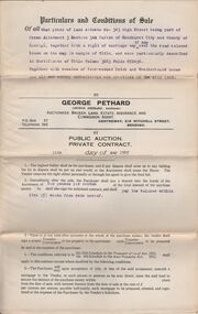
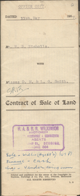 Bendigo Historical Society Inc.
Document - H.A. & S.R. WILKINSON COLLECTION: CONTRACT OF SALE
Contract of sale of land dated 11th May, 1957 between Mr. W.B. Nicholls (seller) and Misses D.M. & L.G. Smith. For land being lot 8 on vendor's plan of subdivision by Mr. Surveyor Pritchard, dated 2nd May, 1957 having a frontage of 59 feet to Alamein Court by a depth of 100 feet, being part allotment 7 section 31A land described in Crown grant volume 8113 folio 731. Subject to any registered appurtenant easements. Price 3,600 pounds.organization, business, h.a. & s.r wilkinson real estate -
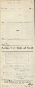 Bendigo Historical Society Inc.
Document - H.A & S.R. WILKINSON COLLECTION: CONTRACT OF SALE
Contract of sale of land dated 29th May, 1954 between Mrs. E.M. & Mr. H.A. Knight (sellers) and Mr. W.H. Randall (buyer) for land being lot 2 on plan of subdivision No. 19227 being parts of lots 27 and 28 on plan of subdivision No. 4134 being part of Crown allotment 97 and being the balance of the land comprised in certificate of titles volume 6441 folios 021 and 022 and situate Albion Street, Bendigo. Together with weatherboard dwelling and all sundry. Price 2,200 pounds.organization, business, h.a. & s.r wilkinson real estate -
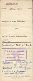 Bendigo Historical Society Inc.
Document - H.A. & S.R. WILKINSON COLLECTION: CONTRACT OF SALE
Contract of sale of land dated 17th April, 1956 between Mr. F.L. & Mrs. M. Hopley (sellers) and Mr. A. & Mrs. V.E. Runting (buyer) for land being Crown allotment 2 section 60C having a frontage of 100 links to Mitchell Street by a depth of 250 links described in certificate of title volume 835 folio 996 and situate No.68 Mitchell Street, Bendigo, together with weatherboard dwelling and all sundry. Also all floor coverings, inside and outside blinds, curtains, electric light fittings and shades. Price 4,750 pounds. Also attached letter from Curnows (Bendigo) to Mr. A. Runting dated 23rd May, 1956 policy of insurance renewal.organization, business, h.a. & s.r wilkinson real estate -
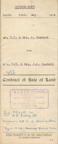 Bendigo Historical Society Inc.
Document - H.A. & S.R. WILKINSON COLLECTION: CONTRACT OF SALE
Contract of sale of land dated 23rd May, 1956 between Mr. W.T. & Mrs. A. Fuzzard (sellers) and Mr. W.T. & Mrs. J.A. Rundell for land being part of allotment 5 section A, Sailors Gully, having a frontage of 66 feet to Sailors Gully Road, Eaglehawk by a depth of 82 feet 6 inches being land described in deed of conveyance book 463 memorial No.742 and situate No. 64 Sailors Gully Road, Eaglehawk, together with 5-roomed weatherboard dwelling. Also all linos, blinds, electric light fittings and shades and electric copper. Price 2,650 pounds.organization, business, h.a. & s.r wilkinson real estate -
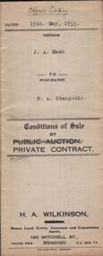 Bendigo Historical Society Inc.
Document - H.A. & S.R. WILKINSON COLLECTION: CONTRACT OF SALE
conditions of sale by private contract dated 15th May, 1933 between J.A. Nash (seller) and F.A. Stacpoole (buyer) for piece of land situate No.133 Sternberg Street,, and Skene Street, Bendigo being allotment 9 and 3 section 39C described in certificate of title volume 1361 folio 272162 and certificate of title volume 3263 folio 652414, together with 10-roomed brick and weatherboard dwelling and shop with street verandah, also gas stove, copper, troughs and bath. Also the complete stock and plant and goodwill of the vendor's butchering business carried on from above shop and premises. Price 1,150 pounds.organization, business, h.a. & s.r wilkinson real estate -
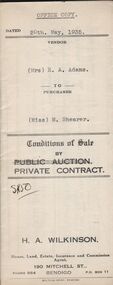 Bendigo Historical Society Inc.
Document - H.A. & S.R. WILKINSON COLLECTION: CONTRACT OF SALE
Conditions of sale by private contract dated 20th May, 1935 between Mrs. E.A. Adams (seller) and Miss M. Shearer (buyer) for land situate 43 Jackson Street, Long Gully being Crown allotment 181 section A and described in certificate of title volume 5564 folio 1112609, together with 4-roomed weatherboard dwelling and all sundry. Price 190 pounds. Also 2 receipts from City of Bendigo for rates.organization, business, h.a. & s.r wilkinson real estate -
 Bendigo Historical Society Inc.
Document - H.A. & S.R. WILKINSON COLLECTION: CONTRACT OF SALE
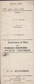
Conditions of sale by private contract dated 29th May, 1935 between A.W. Jordan (seller) and H. Stanyer (buyer) for land situate No.45 Abbott Street, Bendigo, together with 4-roomed weatherboard dwelling and all sundry. Price 275 pounds.organization, business, h.a. & s.r wilkinson real estate -
 Bendigo Historical Society Inc.
Document - H.A. & S.R. WILKINSON COLLECTION: CONTRACT OF SALE
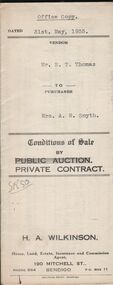
Conditions of sale by private contract dated 31st May, 1935 between Mr. E.T. Thomas (seller) and Mrs. A.M. Smyth for land, as fenced, situate corner Hargreaves and Wattle Streets, Bendigo, being Crown allotment 25 section 97C described in certificate of title volume 1662 folio 332318. Also land adjoining the above, together with 6-roomed weatherboard dwelling and all sundry. Price 435 pounds.organization, business, h.a. & s.r wilkinson real estate -
 Bendigo Historical Society Inc.
Document - H.A. & S.R. WILKINSON COLLECTION: CONTRACT OF SALE
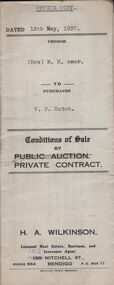
Conditions of sale by private contract dated 13th May, 1937 between Mrs. M.H. Amor (seller) and V.F. Sutch (buyer) for land situate Hayes Street, Bendigo being lot 2 on plan of subdivision, having a frontage of approx. 57 feet to Hayes Street, by a varying depth, being part of Crown allotment 510 section A. Price 60 pounds.organization, business, h.a. & s.r wilkinson real estate -
 Bendigo Historical Society Inc.
Document - H.A. & S.R. WILKINSON COLLECTION: CONTRACT OF SALE
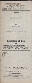
Conditions of sale by private contract dated 20th May, 1938 between G. Earl Snr. (seller) and Mrs. M.A. Speechley (buyer) for land situate No.144 Victoria Street, Ironbark, being the land described in right to occupy residence area No. 4785, together with 4-roomed weatherboard dwelling, brick and concrete kitchen and all sundry. Also copper and stand, electric light fittings, wire doors and window screens. Price 210 pounds.organization, business, h.a. & s.r wilkinson real estate -
 Bendigo Historical Society Inc.
Document - H.A. & S.R. WILKINSON COLLECTION: CONTRACT OF SALE
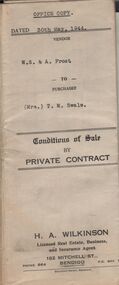
Conditions of sale by private contract dated 30th May, 1944 between W.S. & A. Frost (sellers) and Mrs. T. M. Swale (buyer) for land situate No. 212 Queen Street, Bendigo being Crown allotment 2 section 139C described in certificate of title volume 4557 folio 911246, together with 5-roomed weatherboard dwelling and all sundry. Price 385 pounds. Also attached 6 receipt 2 issued by George Rasmussen, 2 by Langley & Son, 1 by J.S. Barker plus 1 Unknown for various materials.organization, business, h.a. & s.r wilkinson real estate -
 Bendigo Historical Society Inc.
Document - H.A. & S.R. WILKINSON COLLECTION: CONTRACT OF SALE
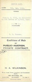
Conditions of sale by private contract dated 7th May, 1934 between Miss M.H. Wild as executrix in the estate of E. Wild deceased (seller) and E.T. Thomas (buyer) for land situate Hargreaves Street corner Wattle Street, Bendigo being Crown allotment 25 section 97C described in certificate of title volume 1562 folio 332318. Also that piece of land adjoining above being land described in residence area certificate No.30319 in the books of the mining registrar at Bendigo. Together with 6-roomedweatherboard dwelling and all sundry. Price 350 pounds.organization, business, h.a. & s.r wilkinson real estate -
 Bendigo Historical Society Inc.
Document - H.A. & S.R. WILKINSON COLLECTION: CONTRACT OF SALE
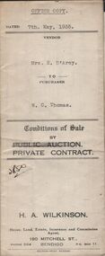
Conditions of sale by private contract dated 7th May, 1935 between Mrs E. D'Arcy (seller) and W.C. Thomas (buyer) for land situate no.55 Wattle Street, Bendigo being Crown allotments 5 & 5A section 129C described in Crown grant volume 563 folio 112554 and Crown grant volume 2079 folio 415637 together with 6-roomed weatherboard dwelling and all sundry. Price 500 pounds.organization, business, h.a. & s.r wilkinson real estate -
 Bendigo Historical Society Inc.
Document - H.A. & S.R. WILKINSON COLLECTION: CONDITION OF SALE
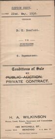
Conditions of sale by private contract dated 22nd May, 1930 between D.K Doxford (seller) and G. Rasmussen (buyer) for land situate in Charles Street, Bendigo, together with 5-roomed weatherboard dwelling and all sundry. Price 440 pounds.organization, business, h.a. & s.r wilkinson real estate -
 Bendigo Historical Society Inc.
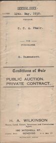
Document - H.A. & S.R. WILKINSON COLLECTION: CONDITION OF SALE
Conditions of sale by private contract dated 12th May, 1930 between C.C.A. Phair (seller) and G. Rasmussen (buyer) for land situate in Long Gully, together with 4-roomed weatherboard dwelling and all sundry. Price 225 poundsorganization, business, h.a. & s.r wilkinson real estate -
 Bendigo Historical Society Inc.
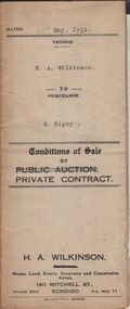
Document - H.A. & S.R. WILKINSON COLLECTION: CONDITION OF SALE
Conditions of sale by private contract dated 12th May, 1932 between H.A. Wilkinson (seller) and S. Rigby (buyer) for land within the special settlement area situate Junortoun containing 17 acres, 1 rood, 27 perches being allotment 37F Parish of Wellsford, County of Bendigo described in Crown grant volume 4485 folio 896958, together with 4-roomed weatherboard dwelling and all sundry. Price 575 pounds.organization, business, h.a. & s.r wilkinson real estate -
 Bendigo Historical Society Inc.
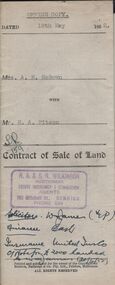
Document - H.A. & S.R WILKINSON COLLECTION: CONDITION OF SALE
Contract of sale of land dated 19th May, 1952 between Mrs. A.M. McGown (seller) and Mr. H.A. Pitson (buyer) for land being Crown allotment 6 section 128C described in certificate of title volume 6410 folio 1281821 situate No. 24 Havelock Street, Bendigo, together with 6-roomed weatherboard dwelling and all sundry. Price 2,800 pounds.organization, business, h.a. & s.r wilkinson real estate -
 Bendigo Historical Society Inc.
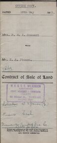
Document - H.A. & S.R. WILKINSON COLLECTION: CONDITION OF SALE
Contract of sale of land dated 12th May, 1953 between Mrs. F.M.T. Crameri (seller) and Mr. H.A. Pitson (buyer) for land being part of Crown allotment 2, section 125C described in certificate of title volume 6429, folio 692 situate No. 79 Garsed Street, Bendigo, together with a right of carriage way over the land coloured blue on the certificate of title with 5-roomed weatherboard dwelling and all sundry. Price 1,825 pounds.organization, business, h.a. & s.r wilkinson real estate -
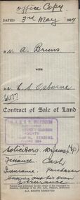 Bendigo Historical Society Inc.
Document - H.A. & S.R. WILKINSON COLLECTION: CONDITION OF SALE
Contract of sale of land dated 3rd May 1954 between Mr.. A. Bruns( seller) and Mr. L.S. Osborne, for land being part of allotment 17 section 129C situate No39 Wattle street, Bendigo described in certificate of title volume 6296 folio 1259099, together with 6-roomed weatherboard dwelling and all sundry. Price 3,925 pounds.organization, business, h.a. & s.r wilkinson real estate -
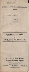 Bendigo Historical Society Inc.
Document - H.A. & S.R. WILKINSON COLLECTION: CONDITION OF SALE
Conditions of sale by private contract dated 20th May, 1943 between A.E. Cowling (seller) and H. Rice (buyer) for land situate Wood Street, Long Gully having a frontage of 150 links to Wood Street by a depth of 200 links and being the land described in right to occupy residence area title No. 4719 due 23/08/1943, together with 5-roomed weatherboard dwelling and all sundry. Price 225 pounds.organization, business, h.a. & s.r wilkinson real estate -
 Bendigo Historical Society Inc.
Document - H.A. & S.R. WILKINSON COLLECTION: CONDITION OF SALE
Conditions of sale by private contract issued by H.A. Wilkinson and dated 25th September 1950 between George Franklin Humphrey & Ethel May Humphries (sellers) and Ernest James Robinson (buyer) for land situate Williams Road Eaglehawk being Crown allotment378 section A Borough of Eaglehawk described in Crown grant volume 3816 folio 763025, together with 4-roomed weatherboard dwelling and all sundry. Price 1,000 pounds.organization, business, h.a. & s.r wilkinson real estate -
 Bendigo Historical Society Inc.
Document - H.A. & S.R. WILKINSON COLLECTION: CONDITION OF SALE
Conditions of sale by private contract dated 11th May, 1925 between F. C. Neivandt and M. Hogan for land situate at 343 High Street described in certificate of title volume 3263 folio 652436, together with remains of 4-roomed brick and weatherboard house. Price 75 pounds.organization, business, h.a. & s.r wilkinson real estate -
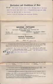 Bendigo Historical Society Inc.
Document - H.A. & S.R. WILKINSON COLLECTION: CONDITION OF SALE
Condition of sale by private contract dated 30th May, 1925 between E. Dobbie and F. C. Neivandt for land at 20 Casey Street held under residence area certificate of registration No. 10890 containing half an acre, together with all buildings. Price 155 pounds.organization, business, h.a. & s.r wilkinson real estate