Showing 73 items
matching office of lands and survey
-
 Bendigo Historical Society Inc.
Document - LANDS OFFICE, REPORTS OF SALES BY PUBLIC AUCTION, 1864 - 1892
... LANDS OFFICE, REPORTS OF SALES BY PUBLIC AUCTION... October 1892. Document LANDS OFFICE, REPORTS OF SALES BY PUBLIC ...Document: buff leather hard covered journal. On spine on red rectangle ' Land sales by public auction' written in gold. On bottom of spine 'Lands and Survey' written in gold on black. On base of spine '4' printed in black. Pages contain details of sales of crown lands by public auction Act 25, Victoria 145. Alphabetical index of counties inside front cover. 443 numbered pages. LH side columns, number, county, parish, section, allotment sold, unsold, price. RH page - improvements, purchaser, residence, amount, later sales have printed notices pasted in. Dated 27 April 1864 to 7 October 1892.Lands and Survey Dept.place, bendigo, public auction, bendigo, sandhurst, crown land, public land auctions, land sales. -
 Bendigo Historical Society Inc.
Document - NOTES ON DUDLEY HOUSE
... District Lands and Survey Office... Society District Lands and Survey Office Supreme Court Building ...Typed notes on Dudley House, its history, description and some of what it looked like when the Branch had it.document, dudley house, bendigo branch of the royal historical society, district lands and survey office, supreme court building, bendigo high school, richard larritt, captain andrew clarke, public offices, post office, law courts, city council, national trust -
Clunes Museum
Document - LAND LICENCE
.1 LICENCES FOR DEPARTMENT OF LANDS AND SURVEY - OCCUPATION BRANCH. LICENCE NO 315892 TO 315901. 25 FEBRUARY 1901 TO FEBRUARY 1902 STAPLED TOGETHER .2 LAND ACT 1869 SEC 20 BOOK 88. ON SPINE "THE CROWN - LAND ACT1869. SEC 20. 88 RECEIPTS FROM REVENUE OFFICE NO 2 TO 118 RECEIPTS 119 TO 249 HAVE NOT BEEN USED, THEY ARE CUT IN HALF.2 WHITE ROUND STICKER WITH "5" ON FRONTdepartment of lands and survey, land act 1869, occupation branch, revenue office -
Clunes Museum
Map - MAPS, AC BROOKS GOVERMENT PRINTER
.1 PARISH OF CLUNES, COUNTY OF TALBOT. STAMP: DRAWING OFFICE RECORDS COPY, STATE ELECTRICITY COMMISSION OF VICTORIA. ELECTRICITY DEPARTMENT (THIS PLAN MUST NOT BE TAKEN FOR FIELD USE. PLEASE DO NOT DEFACE) C71 ON LEFT BOTTOM CORNER, CLUNES SHEET 1 .2 MAP BECKWORTH COUNTY OF TALBOT. IN RED: B-61. L.4855. THE ALLOTMENTS COLOURED BROWN ARE FREEHOLD.1.2 DRAWN AND REPRODUCED AT THE DEPARTMENT OF LANDS & SURVEY MELBOURNE. PRICE 2/- .1 IN PENCIL ON BOTTOM ' 211 ' 20%parish of clunes, electricity supply department, beckworth -
 Forests Commission Retired Personnel Association (FCRPA)
Beechworth FCV District office sign
This sign proudly hung outside the Forests Commission Victoria (FCV) Beechworth office which is now site of the Forestry Heritage Museum. The granite building in the Beechworth's historic precinct was once the Gold Warden's Office and is one of the town's original buildings. The FCV was the main government authority responsible for management and protection of State forests in Victoria between 1918 and 1983. The Commission was responsible for ″forest policy, prevention and suppression of bushfires, issuing leases and licences, planting and thinning of forests, the development of plantations, reforestation, nurseries, forestry education, the development of commercial timber harvesting and marketing of produce, building and maintaining forest roads, provision of recreation facilities, protection of water, soils and wildlife, forest research and making recommendations on the acquisition or alienation of land for forest purposes″. The Forests Commission had a long and proud history of innovation and of managing Victoria's State forests but in September 1983 lost its discrete identity when it was merged into the newly formed Victorian Department of Conservation, Forests and Lands (CFL) along with the Crown Lands and Survey Department, National Park Service, Soil Conservation Authority and Fisheries and Wildlife Service. After the amalgamation the management of State forests and the forestry profession continued but the tempo of change accelerated, with many more departmental restructures occurring over the subsequent four decades. Responsibilities are currently split between the Department of Energy, Environment and Climate Action (DEECA), Forests Fire Management Victoria (FFMV), Parks Victoria, Melbourne Water, Alpine Resorts Commission, the State Government-owned commercial entity VicForests and the privately owned Hancock Victorian Plantations (HVP).Large office sign. Hand painted in traditional FCV mission brown and gold colour scheme. -
 Bendigo Historical Society Inc.
Administrative record - Lands Office Bendigo - Exemptions and Applications
... Lands Office Bendigo - Exemptions and Applications... the years 1937 to 1939. Administrative record Lands Office Bendigo ...Blue and red hardcover book containing pages of handwritten entries of exemptions and applications to purchase land at various places. The book covers the years 1937 to 1939."Exemptions and Applications" handwritten on label on front cover. Attendance, Lands & Survey in gold letters on the spine.land office, government, land purchases -
 University of Melbourne, Burnley Campus Archives
Plan, Plan of Richmond Park, 1886-1948
(1) Black and white photographed copy of an original coloured plan. Plan of Richmond Park with Horticultural Society Gardens marked in. Includes additional land which became the Field Station. Stamp, "Neg. 18375 Department of Lands and Survey Photographed at the Central Plan Office 1/1 Plate 7.12.48". Original plan dated 19.11.86 showing land, "Permanently Preserved for the Gardens." (2) Also 2 photocopies, 1 reduced - possibly used in a publicationgardens, richmond, horticultural society of victoria -
University of Melbourne, Burnley Campus Archives
Plan - Photocopy, Proposed Reserve for Horticultural and Experimental Garden in the Survey Paddock Richmond, 1862-1948
Photocopy of Plan Gazetted 01.08.1863. From Central Plan Office Department of Natural Resources.Signed by Clement Hodgkinson, Deputy Surveyor General. Stamped Department of Lands and Survey 7.12.48 Neg.18377. Handwritten notes on it, "Melb Roll 23 R.19(A)"exprimental gardens, burnley -
 University of Melbourne, Burnley Campus Archives
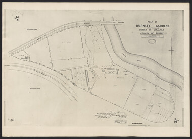
Photograph - Plan of Burnley Gardens
... , Richmond Park to the south west. Photographed at Dept. of Lands..., Richmond Park to the south west. Photographed at Dept. of Lands ..."This plan is a copy of a copy of the survey made by Mr. Turner in 1926. The original plan and field notes are missing _ file Rs 3529" Signed by _signature unreadable_ -
 Falls Creek Historical Society
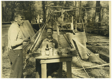
Photograph - Big River Survey Camp, c1949
... of the Hydro Scheme. In 1946 Ray Meyer made a trip to the Lands Office... of the Hydro Scheme. In 1946 Ray Meyer made a trip to the Lands Office ...MEYER COLLECTION - FALLS CREEK PHOTOS In 1947 a determined group of like-minded State Electricity Commission (SEC) staff including Ray Meyer, the chief surveyor of the Kiewa Hydro-Electric Scheme, had a common interest that revolved around the skiing potential of the snow-covered high plains which included what is now the resort of Falls Creek. The six SEC employees, Toni St Elmo, Ray Meyer, Jack Minogue, Lloyd Dunn, Adrian Ruffenacht and Dave Gibson (together with their families) banded together to secretly build a 'hut' that was the first ski lodge at Falls Creek. Using a road built in 1930s to gain access to Falls Creek, their hut project was carried out in secret as efforts by other skiers were blocked by H.H.C. Williams – the engineer in charge of the Hydro Scheme. In 1946 Ray Meyer made a trip to the Lands Office in Melbourne. He came away with a 99-year lease on three acres that was ideally suited for a hut designed by Lloyd Dunn. Adrian Ruffenacht (Design Engineer for the KHS) had suggested where the group should build because of easy access to a spring for water. Much of the building material required was scavenged from derelict huts on the high plains. Due to the need for secrecy, the determined group worked on the hut in the evenings and weekends to avoid detection. During the building period the group had met at Echidna Rock (now known as Eagle Rock) where Skippy St Elmo announced, "This is my favourite ‘Skyline’.” And so the first lodge in the area at Falls Creek Ski Resort came into existence. With the development of the International Poma in the 1970s, the Skyline Lodge, which was sited between the ski-lift’s pole one and pole two, was demolished. However, the legacy of Ray Meyer, Toni St Elmo, Jack Minogue, Lloyd Dunn, Adrian Ruffenacht and Dave Gibson and Skyline lives on in the vibrant atmosphere of Falls Creek Resort. The MEYER COLLECTION documents developments on the Kiewa Hydro Scheme and their life at Falls Creek from the mid 1930s to 1960s.This image is significant because it documents development of the Kiewa Hydroelectric Scheme.Two black and white images at the Big River Old Survey Camp.Photo 1 - Breakfast at Big River Left to RIght Ray Meyer, Wal Johnson Photo 2 - Big River Survey Camp at foot of T Spur C 1949, Kiewa RIver Survey Team.kiewa hydroelectric scheme, ray meyer, wal johnson -
Tarnagulla History Archive
Telegram, March 1862
Donald Clark Collection. A large lot of papers, including this and many other telegrams, were apparently found in the ceiling cavity of the Sandy Creek/Tarnagulla Post and Telegraph Office in the later 20th Century, during building works.Telegram sent from Tarnagulla Telegraph Office from Chas Harding to Frederic Harding at the Department of Lands a& Survey, Melbourne. Text reads "Wait no selling. Gold struck in works'. -
 Federation University Historical Collection
Map - Geological Survey, J. Phillips, Geological Survey of Victoria - Ballarat, 1857, 10/1858
Geological map of the Ballarat District featuring four colours.ballarat, geological, geology, geological plan, main road, camp, golden point, pennyweight hill, clayton hill, ballaarat cemetery, bakery hill, specimen hill, soldiers hill, nightingale lead, native youth black hill flat, white flat, mining, mines, eureka lead, old post office hill -
Bendigo Historical Society Inc.
Book - LANDS OFFICE: INDEX LANDS AND SURVEY
... LANDS OFFICE: INDEX LANDS AND SURVEY...Lands office...Lands office Index survey Index lands and Survey. Sandhurst ...Index lands and Survey. Sandhurst, Kangaroo Flat, Eaglehawk, White Hills, And Nerring. Land Sales, Beginning April 17, 1854. The last entry is dated 23.9.74. markings on spine of book are at top 04 in black, in gold lettering index lands and Survey, in black Bendigo, Eaglehawk, Kangaroo Flat White Hills and Nerring, near the bottom is the letter B in black, a white sticker with the letters VV. Read in conjunction with 2239 (a to g), located in Box 77.lands office, index, survey