Showing 1396 items
matching allotments
-
 Whitehorse Historical Society Inc.
Map, Boroondara, Nunawading, 1853
Map of section of Parishes of Boroondara and NunawadingMap of section of Parishes of Boroondara and Nunawading with allotments numbered and named. Note on verso: Boroondara and Nunawading c1853.Map of section of Parishes of Boroondara and Nunawading maps, parish of nunawading, parish of boroondara -
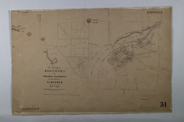 Bendigo Historical Society Inc.
Map - KOOYOORA, July 23rd 1857
... Allotments ...Map: The Township of Kooyoora and suburban allotments in the Parish of Kingower. This plan has been applied to a newer backingmap, township, kooyoora, allotments, parish of kingower -
Whitehorse Historical Society Inc.
Document, Heatherdale Estate, Mitcham, n.d
Private sale brochure for the Heatherdale Estate, Mitcham.Private sale brochure for the Heatherdale Estate, Mitcham, comprising 195 allotments. Sale agent Drake & Co., Mitcham.Private sale brochure for the Heatherdale Estate, Mitcham. heatherdale estate, mitcham, kulnine avenue, mitcham, purches street, mitcham, culwel avenue, mitcham, walwa street, mitcham, blossom street, mitcham, nymph street, mitcham, heatherdale road, mitcham, drake co. -
Bendigo Historical Society Inc.
Map - CRAVEN'S ALLOTMENTS , NEW CHUM, No date visible
... allotments ...Map: Craven's Allotments, New Chum. Hand Draughted plan showng the corner of McKenzie and Rose streets Bendigo.map, bendigo, allotments, cravens allotments, new chum -
 Kiewa Valley Historical Society
Parish Maps - Kiewa Valley
The Parish Maps show how the Counties were divided into allotments for buyers. On one the original owners are named and the sizes of their properties given. The reference numbers enable individuals research the history of the property. The other is on a smaller scale giving only the allotment numbers. The map with the names gives information on the early settlers of the Kiewa Valley. They show how the Kiewa Valley was divided up into allotments for town dwellers and farmers and enables further research.Two copies of Parish Maps of the towns in the Kiewa Valley. One gives the original owners and the other the reference numbers of the allotments.kiewa valley. parish maps. land owners -
Linton and District Historical Society Inc
Purchase Document, Grant By Purchase, Special Land Sale,1861: Sale of land to Henry Franks
The Allotment was purchased as part of a sale of Special Lands at Linton on the 9th of April 1861 The amount paid was £16 15s.Photocopy of a document which records the purchase by H. Franks of Allotment 15, Section 1, Township of Linton. henry franks, allotment 15 section 1 township of linton, special land sale 1861, documents and records -
Whitehorse Historical Society Inc.
Document, The Savage Estate, n.d
Private sale leaflet of The Savage Estate Springfield Road, Nunawading.Private sale leaflet of The Savage Estate Springfield Road, Nunawading, comprising 46 allotments. Agents Drake & Co and Armstrong & Hoath.Private sale leaflet of The Savage Estate Springfield Road, Nunawading. savage estate, nunawading, springfield road, nunawading, drake co, armstrong hoath estate agents -
Whitehorse Historical Society Inc.
Map, Plan of the Parish of Nunawading, 1853
Photocopy of map showing names of selectors, also list of references to the corners of allotments.Photocopy of map showing names of selectors, also list of references to the corners of allotments. Note on verso:'Gardiners Creek, Ballyshanassey township surveyed by H. Parmein, Surveyor General's Office Nov 30, 1853 also Reference to the Corners of allotments' (Plan 428)Photocopy of map showing names of selectors, also list of references to the corners of allotments. land subdivision, gardiners creek, ballyshanassy, parmein, h, burwood east, maps -
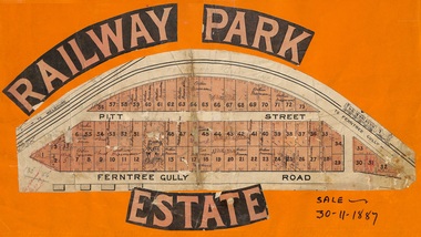 Ringwood and District Historical Society
Flyer, Subdivision sale poster - Railway Park Estate, Ringwood, Victoria - 1887
Collage of clipped lettering and map pasted to orange coloured card depicting Railway Park Estate subdivision sale. Handwritten names associated with allotments and notation of sale date - 30 November, 1887. Subdivision plan with pink shading highlighting 73 allotments in Ferntree Gully Road (later Bedford Road) and Pitt Street, Ringwood. Handwritten names associated with allotments include Arthur Wiseman, T. Grant, J.J. Miller, M. Dickson, G.G. Miller, J. Frost, J.K. Turnbul, J.W. Davis, William Aldridge. -
Linton and District Historical Society Inc
Documents - purchase of land, Purchase of land by David McFadzean, 1872 - Allotment A1A, Township of Linton, Parish of Argyle
The land was purchased by David McFadzean under the 42nd section of the Amending Land Act, 1865. This allowed long-term tenants ("licensees") of government-held land to purchase ("alienate") the land. The allotment is in present-day Jackson Street, Linton.Twelve A4-size photocopies of documents relating to the purchase of an allotment of land - Allotment A1A, measuring 5 acres, 3 roods and 37 perches - within the boundaries of the Township of Linton. First page is headed "SECTION 31, "LAND ACT 1869". Documents include David McFadzean's application to purchase, notes made about the land and the application by officers of the Board of Land and Works, a plan of the allotment, and information about purchase price and fees.allotment a1a township of linton, david mcfadzean, victoria. amending land act 1865, conveyance, land sales, land purchases, documents and records, james beament -
Bendigo Historical Society Inc.
Map - CAMPBELL COLLECTION: BENDIGO AND DISTRICT MAPS
... allotments ...Map. Whirrakee, Parish of Whirrakee. Total area of map 4419 acres. Scale 20 chains to 1 inch. 23 allotments are sold, Eucalypt oil distillery on lower portion of map. Prepared in W.P.B. from Assessor's plan and Parish Plan. (number 350 in map cupboard 1)map, bendigo, allotments -
Bendigo Historical Society Inc.
Map - AVAILABLE ALLOTMENTS, 10/08/1908
... allotments ...map: Available Allotments, Parishes of Whirrakee, Bagshot and Egerton, County of Bendigo. Parish plan (coloured) (number 330 in map cupboard 1)map, bendigo, allotments, available allotments, whirrakee, bagshot, egerton -
 Bacchus Marsh & District Historical Society
Map, Plan of the second portion of the property of Messers Atkins and Clarke situate at Bacchus Marsh 1856
This plan of land allotments for sale indicates part of the property once owned by the Bacchus family in and around the township area of Bacchus Marsh. The Bacchus family sold their property in Bacchus Marsh to John Aitkins and Robert Nalder Clarke in March 1851. Aitkins and Clarke kept the property for a number of years until April 1856 when these allotments were put up for sale.This is a very early land sales plan for agricultural land close to the township of Bacchus Marsh. It therefore provides some clues as to how the early urban development of the township and agricultural development of the nearby area took place. Upon seeing the map in 1911 Bacchus Marsh Express newspaper editor Christopher Crisp wrote "The sale appears to have created the present township, which had a nucleus in earlier times further east", Express, 30 September, 1911, page 3.A single page paper plan showing allotments of land for sale. The subdivided land shown was owned by John Aitkins and Robert Nalder Clarke, but previously owned by the Bacchus Family and was in and around their Manor House (Mansion) property in Bacchus Marsh. This plan shows allotments in the second portion of land to be sold which was located east of the Manor House on the eastern side of the Lerderderg River. The land for sale was made up of 15 allotments. The plan is pasted into a bound volume containing 76 maps or plans in total. BMDHS Loc: AR/B12/S4 Bacchus Marsh Township and Nearby Districts Maps Volume In-house Digital copies: BMDHS, Computer Network: Maps\Bacchus Marsh Township and Nearby Districts Maps Volumebacchus marsh victoria maps, bacchus family, land sales, manor house bacchus marsh -
 Bacchus Marsh & District Historical Society
Map, Plan of Survey of Part of Crown Allotment 9, Parish of Korkuperrimul, 1890
This map documents a transfer of an allotment of land in Clarke Street Bacchus Marsh in 1890. Clarke Street is located on the eastern side of Bacchus Marsh not far from Main Street and Crook Street. It is now known as Candeloro Street. The map indicates J. Booth as the owner of the land and H. Simpson as the occupier. Next to this allotment is a an allotment of land owned by J. Elmore,Single page map showing Crown allotment 9, Parish of Korkuperrimul, County of Bourke. Scale 100 feet to inch. Part of a set of maps which are pasted into a bound volume containing 76 maps or plans in total. High resolution digital image stored on BMDHS computer network. At bottom of map: I hereby certify that I have made this survey expressly for the purpose of an application under the Transfer of Land Statute that this plan is correct. Barry B???, Lic. Surveyor, 16.10.90bacchus marsh victoria maps, clarke street bacchus marsh maps -
Whitehorse Historical Society Inc.
Document, McGlone's Estate Mitcham, 1/04/1921 12:00:00 AM
Copy of pamphlet of McGlone's Estate, Mitcham auctioned April 1921.Copy of pamphlet of McGlone's Estate, Mitcham auctioned April 1921. 24 allotments. Bordered by Whitehorse Road, McGlone Street, Station Street and Mitcham railway line and station. Original in Haughton maps, LaTrobe Library.Copy of pamphlet of McGlone's Estate, Mitcham auctioned April 1921. land sales, auctions, mcglone, john, mcglone, elizabeth, whitehorse road, mitcham, mcglone street, mitcham, station street, mitcham, mitcham railway station, haughton map collection, state library of victoria. latrobe library -
University of Melbourne, Burnley Campus Archives
Book, Royal Horticultural Society, The Vegetable Garden Displayed, 1959
... allotments ...Book with light cardboard cover. Produced by the Royal Horticultural Society, London. Eleventh Impression 365th thousand, 1949. Very detailed descriptions of how to plant out gardens or allotments. Individual vegetables described. Photographs from Wisley, Surrey.vegetables, vegetable growing, home gardening, royal horticultural society, allotments, wisley -
Whitehorse Historical Society Inc.
Map, Site for Wesleyan Church, Nunawading, 1855
Photocopy of manuscript map showing names of landholders.Photocopy of manuscript map showing names of landholders. Note on verso: Plan of allotments in the City of Melbourne appropriated to the Wesleyans. Site for Wesleyan Church, Nunawading 1848 (Corner of Burwood and Elgar Roads - S of Burwood, W of Elgar)Photocopy of manuscript map showing names of landholders. churches, wesleyan church, burwood, burwood road, burwood, elgar road, burwood, maps -
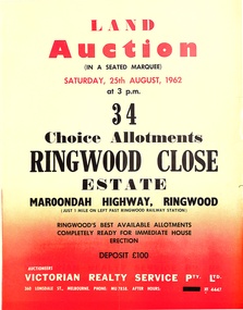 Ringwood and District Historical Society
Pamphlet, Land Auction Brochure - Ringwood Close Estate, Ringwood, Victoria - 1962
Brochure advertising public auction of 34 allotments on Saturday 25th August, 1962. Brochure includes terms of sale, description of subdivision features and local facilities, with locality map. Subdivision includes Anthony Court, Nina Court and Wingrove Place, off Maroondah Highway, Ringwood.Auctioneer - Lindsay Lord, Victorian Realty Service Pty Ltd., 360 Lonsdale Street, Melbourne. Phone MU7858, After hours XF4447. Map includes handwritten pricing notations for some allotments. -
Whitehorse Historical Society Inc.
Document, Certificate of Title, 1922, 1933
Certificate of Title, Margaret Kennedy.Certificate of Title, Margaret Kennedy. Lots 100, 101 & 102, subdivision 1968, part of crown allotment 1270, Parish of Nunawading, County of Bourke 1922 vol 4583, fol 916577 also rates enforcement of charge, 1933.Certificate of Title, Margaret Kennedy.land titles, shire of blackburn and mitcham, kennedy, margaret, mcdowall street, mitcham -
Whitehorse Historical Society Inc.
Document, Certificate of Title, 1915, 1933
Certificate of Title, Frederick William GibbonsCertificate of Title, Frederick William Gibbons, Lot 88, Subdivision 1968, part of crown allotment 1270, Parish of Nunawading, County of Bourke 1915. Vol 3882, fol 776385 also correspondence re rates, enforcement of charge, 1933.Certificate of Title, Frederick William Gibbonsland titles, shire of blackburn and mitcham, gibbons, frederick william, shire of nunawading, burnett street, mitcham, gort road, mitcham -
Linton and District Historical Society Inc
Certificate of Title, Certificate of Title: Allotment 36, Section 4, Township of Linton
Title of the land was transferred to James Adolphus Nelson and Theophilus William Nelson in 1955. James and Theo Nelson had already purchased adjacent allotments 27 - 30 in 1929.Copy of a Certificate of Title for an allotment of land situated between Grantley Street and Springdallah Creek in Linton. Copy comprised of three photostat sheets held together by tape. Most recent holders of the Title recorded as James Adolphus Nelson and Theophilus William Nelson.certificates of title, allotment 36 section 4 township of linton, james adolphus nelson, theophilus william nelson -
 Ballan Shire Historical Society
Map - Map. Bungal, Department of Lands and Survey, Bungal, County of Grant, 09/09/1926
A map of Bungal in the 1920's showing the allotments, and the size, with the names of the residents. It shows the roads and the Western and Eastern Moorarbool River, and the Whipstick State Forest.Cream coloured map of Bungal in the County of Grant, bounded by the the East Moorarbool River on the East, and the State Forest on the South. It is marked with the scale of chains and the number L.358. Lithographed at the Department of Lands and Survey. Melbourne by W. J. Butson on 9.9.1926. It shows the land allotments with names of owners.Coloured pen marks and circled numbers on various areas. Price 2 shillings marked on bottom right hand edge.bungal, kerrit bareet, egerton, lal lal, borhoneyghurk, bungeeltap, ballark, yaloak, gorong, moorarbool west -
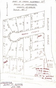 Ringwood and District Historical Society
Map, Subdivision Plan - Adam Court area, North Ringwood, Vic. - circa 1960s
Single page plan printed showing allotments included in un-named subdivision layout surrounding Adam Court, Ringwood North. Subdivision includes Adam Court, Burlock Avenue, and Felix Crescent. Sold allotmenets marked in red, with price notations.Page heading - Part of Crown Allotment 27B Parish of Warrandyte County of Evelyn Scale 60'-1". Rubber stamp imprint and handwritten address at bottom of page - "Binburra Estates Pty. Ltd. 23 Pitt St., Ringwood, 870-1184". -
Whitehorse Historical Society Inc.
Document, Certificate of Title, 1923 - 1934
Certificate of Title, William Arthur Hirst.Certificate of Title, William Arthur Hirst. Lot 20 Subdivision 6626, part of crown allotment 127A at Mitcham, Parish of Nunawading, Count of Bourke. Vol 4671, fol 934063. Also correspondence re rates enforcement charge, 1933-34.Certificate of Title, William Arthur Hirst.land titles, shire of blackburn and mitcham, hirst, william arthur, shire of nunawading, thomas street, mitcham -
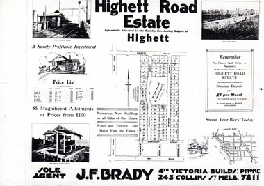 City of Moorabbin Historical Society (Operating the Box Cottage Museum)
Flyer - Highett Road Estate, Highett
With the growth of Melbourne the market gardens were subdivided into building blocks as the land was worth more than the value of the crops.Example of the progress of the Municipality of MoorabbinPhotocopy of advertisement of private sale of housing lots in Highett.Highett Road Estate, Highett - 85 Magnificent Allotmentshighett road, wilson st, dalmont street, highett, real estate -
Clunes Museum
Map, DEPARTMENT OF LANDS AND SURVEY
MAP OF ALLOTMENTS IN CLUNESlocal history, documents, map, township, clunes -
 Falls Creek Historical Society
Plan - Leases of part of Falls Creek Tourist Area
Bob (Herman) Hymans (a former member of the Royal Netherlands Navy was born in Bloemendaal, Holland on 30th September 1922. During World War II he fought against the Japanese in the Dutch East Indies (now Indonesia) and was imprisoned in Changi and on the Burma Railway. After gaining qualifications as a Ski Instructor, Bob arrived in Falls Creek in May 1950. Working as an Instructor and Supervisor at Bogong Lodge, Bob decided his future was in accommodation. He was successful in negotiating an indenture for land from the State Electricity Commission (SEC). It took Bob two years to build his Grande Coeur Chalet but, tragically, it was burned down in August 1961. Bob also built the first Chairlift in Australia. This was a single chairlift and the structure was built from wooden electricity poles. He was constantly full of new ideas and proposals for the village. Bob Hymans died on 7th May 2007. This Collection of documents and letters tells the story of Bob’s endeavours to develop Falls Creek into the ski village it is today. This map is significant because it documents boundaries of early leases in Falls Creek Tourist Area.This map is part of Bob Hymans documents. It is a large Surveyor's Plan of a section of the Falls Creek Tourist Area. It is endorsed by J Parker, Chief Surveyor of the State Electricity Commission of Victoria on 27-3-84. It shows streets, lot numbers and measurements. It was a compilation created from existing lease maps. Heading - PART OF FALLS CREEK TOURIST AREA PART OF CROWN ALLOTMENT 1 PARISH OF CARRUNO PART OF CROWN ALLOTMENT 1 PARISH OF DARBALANG COUNTY OF BOGONGmap of falls creek, falls creek leases, falls creek 1980s -
 City of Moorabbin Historical Society (Operating the Box Cottage Museum)
Flyer - Ozone Hill Estate, Cheltenham, 1923
The train line from the city to Frankston was electrified in 1922 which intensified the sale in the municipality of Moorabbin, particularly land which was in the vicinity of the railway stations.Example of the progress of the Municipality of MoorabbinPhotocopy of Advertising flyer for sale of real estate sales - plan of building blocks for saleOzone Hill Estate, Cheltenham 41 choice residential allotments.victor avenue, weatherall road, cheltenham, real estate, auction -
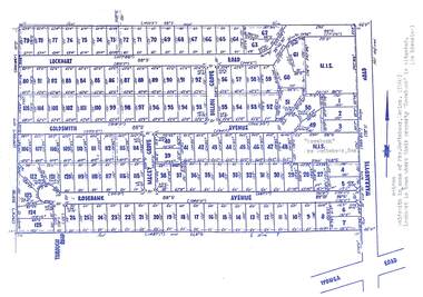 Ringwood and District Historical Society
Map, Subdivision Plan - Rosebank Avenue area, North Ringwood, Vic. - circa 1960s
Single page plan printed on green background showing allotments included in un-named subdivision layout surrounding "Rosebank" property, Warrandyte Road, Ringwood North. Subdivision includes Through Road, Rosebank Avenue, Macey Grove, Goldsmith Avenue, Dillon Grove, Lockhart Road, and Warrandyte Road.Typewritten notation against "Rosebank" property - "Mrs Godbehear, Snr.". "Goldsmith is maiden name of Mrs. Godbehear, Senior. (1960). Lockhart is town where their property "Rosebank" is situated. (In Riverina)". Additional Rosebank Avenue allotments blueprint clipping on light cardboard backing incldes handwritten title reference LP57659. -
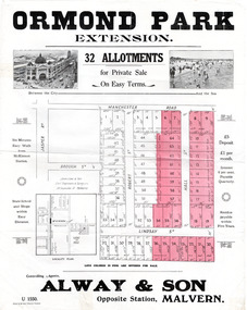 City of Moorabbin Historical Society (Operating the Box Cottage Museum)
Flyer - Ormond Park Extension, Ormond, 1924
The train line from the city to Frankston was electrified which intensified the sale in the municipality of Moorabbin, particularly land which was in the vicinity of the railway stations.Example of the progress of the Municipality of MoorabbinAdvertising flyer for auction of real estate sales - plan of building blocks for saleOrmond Park Extension - 32 Allotment for Private Sale - Alway & Sonmanchester road (now mckinnon road), lindsay street, hall street, ormond, real estate