Showing 15859 items
matching areas
-
 Friends of Ballarat Botanical Gardens History Group
Work on paper - A Brief History of the Ballarat Botanic Gardens, Curators, Statuary, Trees and Other Notable Areas
... Curators, Statuary, Trees and Other Notable Areas. ...john garner collection, ballarat botanical gardens, gardens, ballarat, history -
Wonga Park Community Cottage History Group
Work on paper (Item) - Report, Undated Review of Statement of Planning Policy Nos. 3 & 4 Dandenong Ranges and River Yarra: Supplementary Report on the Policy Areas
... Areas ... -
University of Melbourne, Burnley Campus Archives
Book - PhD Thesis, Sabine Thea Emmy Spohn, Embedding Microfinance: Sustainable Delivery of Microfinance Services in Rural Areas of Papua New Guinea, 2010
... Microfinance Services in Rural Areas of Papua New Guinea ...agricultural science, phd thesis, microfinance services -
Merbein District Historical Society
Book, Frost Control in the Australian Dried Fruit Areas, May.1948
... Frost Control in the Australian Dried Fruit Areas ...a.v. lyon, merbein tonwship, csiro research station, frost control, fruits -
University of Melbourne, Burnley Campus Archives
Newspaper - Newspaper Cutting, The Age, Child Play Areas in New Housing, 1961
... Child Play Areas in New Housing ...Margaret Hendry (Graduated 1948, Staff 1950-1952). Landscape Assistant for the Basildon Development Corporation in Essex, UK.Article in "The Age" September 27, 1961 about Margaret Hendrythe age, margaret hendry, landscape designer, student, basildon development corporation -
University of Melbourne, Burnley Campus Archives
Book, J. E. Jessup et al, Pasture and Fodder Crops for the Murrumbidgee and Coleambally Irrigation Areas and Associated Districtsd, 1967
... Coleambally Irrigation Areas and Associated Districtsd ...Book with heavy paper cover and staples. N.S.W. Dept. of Agriculture Division of Plant Industry Bulletin P248, 1967. By J. E. Jessup, Special Agronomist, Formerly District Agronomist, Leeton and D. E. Wallin, District Agronomist, Griffin.pastures, fodder crops, murrumbidgee, coleambally, irrigation, agronomy -
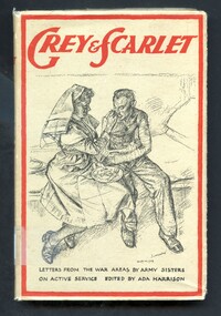 Alfred Hospital Nurses League - Nursing Archive
Book - Illustrated book, Robert Austin, Grey and scarlet: letters from war areas by army sisters on active serevice, 1944
... Grey and scarlet: letters from war areas by army sisters on ...A collection of letters from members of the Queen Alexandra's Imperial Military Nursing Service on the front line during World War 2, including Tobruk, Greece and SingaporeIllustrated book with dust jacket. Book has a grey cover with title editors name and printer's mark printed in red on spine. Dust jacket has a grey background on the front and spine. The front has a drawing in lead pencil by Robert Austin of a nurse feeding a soldier with bandaged arms, they are seated beside each other on a bed. The main title is printed in red above this drawing, remainder of title and editor's name is printed in black below the drawing. The front also has a thick red border. Title and publisher's name also printed on the spine. Information about the book is printed in black on a white background on the backnon-fictionA collection of letters from members of the Queen Alexandra's Imperial Military Nursing Service on the front line during World War 2, including Tobruk, Greece and Singaporeworld war 1939-peronal narratives-british, queen alexandra's imperial military nursing service, nurses -
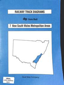 Victorian Railway History Library
Book, Yonge, John, Railway Track Diagrams 7 - New South Wales Metropolitan Areas, 1998
... Areas ...Railway & tramway maps of New South Wales from Canberra to Newcastle including Sydney and the Metropolitan area.maps, p.20.non-fictionRailway & tramway maps of New South Wales from Canberra to Newcastle including Sydney and the Metropolitan area. railway & tramway maps - nsw, railroad operations - new south wales - history -
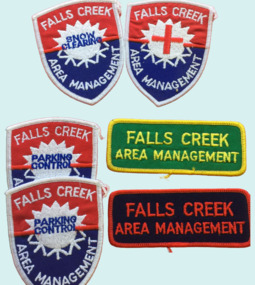 Falls Creek Historical Society
Badge - Falls Creek Area Management Cloth Badges
Falls Creek was operated by the Falls Creek Area Management Committee. Its composition changed over time but generally the Committee was composed of representatives of the State Electricity Commission, Representatives from Ski Clubs and commercial enterprises, the Country Roads Board, the Ski Tow company and a Representative of the Upper Murray Regional Committee of the Central Planning Authority. This Committee was responsibility for long term planning for the Falls Creek Tourist Area as well as the day to day running of the Village, These patches were part of the uniform of people employed by the Management Committee.These cloth badges are significant because they indicated employees of the Area Management Committee and the role they played in Falls Creek.A group of cloth badges indicating the role of personnel employed by the Falls Creek Area Management. Shield shaped badges - 2 Falls Creek Area Management - PARKING CONTROL 1 Falls Creek Area Management - with red cross of SKI PATROL Rectangular - Green and yellow - FALLS CREEK AREA MANAGEMENT Red and blue - FALLS CREEK AREA MANAGEMENTfalls creek village, falls creek area management committee -
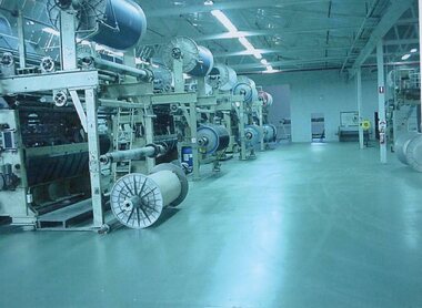 Stawell Historical Society Inc
Photograph - Aunde Album 29, Raschel Area, 2002
Aunde / Norwellan Textiles North Western Woolen Mills became Norwellan Textiles then AUNDEColour landscape photo: Raschel Area Spools on machinesRaschel Areaindustry, aunde -
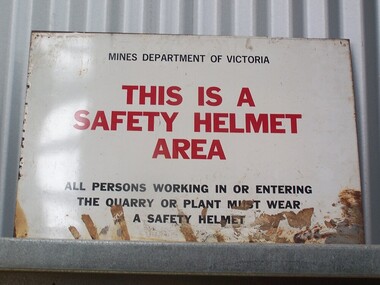 Puffing Billy Railway
Sign - Safety Helmet Area
Sign - Safety Helmet Area, Mines Dept. of VictoriaHistoric - Safety Sign used by Mines Dept. of Victoriametal sign - Sign - Safety Helmet Area Mines Department of Victoria This is a Safety Helmet Area All persons working in or Entering The Quarry or Plant must wear A Safety Helmetpuffing billy, sign - safety helmet area,, mines dept. of victoria -
Whitehorse Historical Society Inc.
Article, Fourth zone added to flats control, 1969
A report on a decision adopted at a Council meeting to divide the municipality into four areas for planning purposes.A report on a decision adopted at a Council meeting to divide the municipality into four areas for planning purposes.A report on a decision adopted at a Council meeting to divide the municipality into four areas for planning purposes.residential development, city of nunawading, town planning -
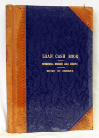 Orbost & District Historical Society
cash book, first half 20th century
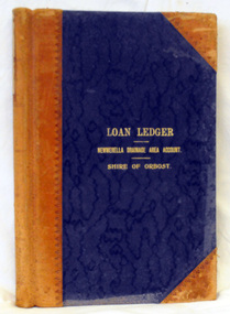
This ledger was used by the Shire of Orbost to record transactions relating bto the Newmerella Drainage Area from 1927 to 1950. The item was donated to Orbost & District Historical society from P.R.O.V. as a Place of Deposit (POD) item for safe keeping by a local history group or museum. The shire covered an area of 9,347 square kilometres and existed from 1892 until 1994 when it became part of the East Gippsland Shire Council. Orbost was at first included in the Bairnsdale Shire from 1882 and was later part of the Tambo Shire. Because of travelling distances the Croajingalong Shire was created in 1892 (name changed to Orbost Shire 17.2.1893 with James Cameron as the first Shire President. In 1994 it amalgamated to become part of East Gippsland Shire Council.This item is a hand-written record of the accounts of the Orbost Shire local government. It pre-dates computer records. The Orbost Shire Council no longer exists having been absorbed into the East Gippsland Shire Council. A ledger with a black cover and brown binding. It has marbled end covers. It contains handwritten records of transactions relating to the Newmerella Drainage Area. On the front cover in gold print is "LOAN CASH BOOK (underlined) NEWMERELLA DRAINAGE AREA ACCOUNT (underlined) SHIRE OF ORBOST". on spine - "Newmerella Drainage Area Cash Book" in gold print.orbost-shire-council ledger accounts newmerella-drainage-area -
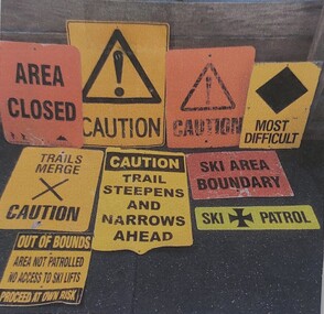 Falls Creek Historical Society
Sign - Falls Creek Ski Patrol
The first ski patroller in Falls Creek was Brian Caddy with two casual ski patrollers Rob Sarroff and David Crooke in the 1960s. In 1972 the “official” Falls Creek Ski Patrol was created under the advisement of Dr Rodney Moss with the support of the Management Committee. By 1977 there were six or seven patrollers, and currently there are around 40 patrollers on the team with 13-14 rostered on each day during peak season. In 1974 the Australian Ski Patrol Association (ASPA) was formed. On the 14th March 1975, the Falls Creek Tourist Area Management Committee applied for membership to ASPA. At that time, Falls Creek Ski Patrol was known as Falls Creek Ski Rescue. From that time, Falls Creek patrollers began wearing the recommended uniform of a white cross on a red parka.These signs are significant as they are representative of the work carried out by Falls Creek Ski Patrol to keep skiers safe.A variety of signs used by Falls Creek Ski Patrol to alert tourists to conditions on the mountains in the area.A range of words and symbols including:- AREA CLOSED CAUTION MOST DIFFICULT TRAILS MERGE - CAUTION CAUTION TRAIL STEEPENS AND NARROWS AHEAD SKI AREA BOUNDARY SKI PATROL OUT OF BOUNDS / AREA NOT PATROLLED / NO ACCESS TO SKI LIFTS / PROCEED AT OWN RISKfalls creek ski patrol, skiing safety -
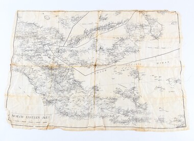 Shepparton RSL Sub Branch
Silk escape map
Used by Allied troops in the Pacific in ww2Silk escape map of Northeastern Area of Papua and New Britain. Black printing on white silk. SCALE 94 mm to 50 miles.Northeastern Area escape map -
 Orbost & District Historical Society
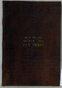
account book, BETE BOLONG DRAINAGE AREA PAY SHEET, 1910 - 1913
This account book was used by the Orbost Shire council to record payments made for work done on the Bete Bolong Drainage Area between 1910 and 1913. The item was donated to Orbost & District Historical society from P.R.O.V. as a Place of Deposit (POD) item for safe keeping by a local history group or museum. The shire covered an area of 9,347 square kilometres and existed from 1892 until 1994 when it became part of the East Gippsland Shire Council. Orbost was at first included in the Bairnsdale Shire from 1882 and was later part of the Tambo Shire. Because of travelling distances the Croajingalong Shire was created in 1892 (name changed to Orbost Shire 17.2.1893 with James Cameron as the first Shire President. In 1994 it amalgamated to become part of East Gippsland Shire Council. This item is a hand-written record of the accounts of the local government. The Orbost Shire Council no longer exists having been absorbed by the East Gippsland Shire Council.A brown leatherette, hard cover book. In gold lettering on the front is "BETE BOLONG DRAINAGE AREA PAY SHEET". It contains records of payments made for work done 1910-1913.In gold lettering on the front is "BETE BOLONG DRAINAGE AREA PAY SHEET".bete-bolong-drainage-area accounts orbost-shire -council -
 Orbost & District Historical Society
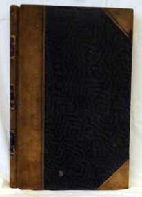
ledger, first half 20th century
This ledger was used by the Shire of Orbost from 1927 -1940. The item was donated to Orbost & District Historical society from P.R.O.V. as a Place of Deposit (POD) item for safe keeping by a local history group or museum. The shire covered an area of 9,347 square kilometres and existed from 1892 until 1994 when it became part of the East Gippsland Shire Council. Orbost was at first included in the Bairnsdale Shire from 1882 and was later part of the Tambo Shire. Because of travelling distances the Croajingalong Shire was created in 1892 (name changed to Orbost Shire 17.2.1893 with James Cameron as the first Shire President. In 1994 it amalgamated to become part of East Gippsland Shire Council. This item is a handwritten record of the accounts of the Orbost Shire local government. It pre-dates computer records. The Orbost Shire Council no longer exists having been absorbed by the East Gippsland Shire Council.A ledger with a black cover and brown leather binding. It has marbled end pages. On the front cover in gold print is " LOAN LEDGER (underlined) NEWMERELLA DRAINAGE AREA ACCOUNT (underlined) SHIRE OF ORBOST.on spine - "Newmerella Drainage Area Loan Ledger"ledger orbost-shire newmerella-drainage-area accounts -
Bendigo Historical Society Inc.
Book - SUBMISSION BY ORDNANCE FACTORY BENDIGO TO SENATE COMMITTEE RE SALE OF ORDNANCE FACTORY, 1981
58 page booklet entitled 'Submission by Ordnance Factory Bendigo Area Committee to Senate Select Committee Reviewing the Proposed Ordnance Factory Bendigo Sale.' October 1981 Includes letters to Government.O.F.B. Area Committee -
 Federation University Historical Collection
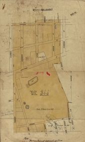
Plan, Ballaarat No 5722, 28/11/1903
Part of the block shaded yellow on the plan contains Phoenix P-12 School Senior CampusPlan of Ballarat with leae area No 5722 coloured yellow. Plan of the streets around Hertford Street, ballarat. The yellow depicts the area leased (No 5722 Ballarat)mining lease 5722 ballarat, ballarat, hertford street, cromwell street, alexandra street, alfred street, verdon street, clarkson street, spencer street, franklin street, hill street, grant street, albion street, rowlands street, edwards street north, mining, cgt, plans, phoenix p-12 school senior campus -
Stawell Historical Society Inc
Archive - Book, Stawell Shire, Registration Of Residence Sites & Index 19-8-1882 - 21-4-1990, 1882
Residence Area Miners Rightused by Stawell ShireLarge Green Covered Leather Ledger with Fawn Covered Spine and CornersResidence Area Register RS3 local government, miners right -
Stawell Historical Society Inc
Archive - Book, Stawell Shire, Registration Of Residence Sites & Index 25-10-1915 - 6-11-1924, 1915
Residence Area Miners Right used by Stawell ShireLarge Green Covered Leather Ledger with Red Covered Spine and Corners with indexRegister of Residence Areas 10P local government, miners right -
Glenelg Shire Council Cultural Collection
Photograph - Photograph - Drilling near Condah Victoria, c. 1960
Possibly from Bowerbird MuseumBlack and white photo last drilling rig in the Condah area.Front: Kevin McLennish The last drilling rig 1960 Condah area Hand written blue biro -
 Orbost & District Historical Society
ledger, first quarter 20th century
This ledger was used by the Shire of Orbost from 1910 -1925. The item was donated to Orbost & District Historical society from P.R.O.V. as a Place of Deposit (POD) item for safe keeping by a local history group or museum. The shire covered an area of 9,347 square kilometres and existed from 1892 until 1994 when it became part of the East Gippsland Shire Council. Orbost was at first included in the Bairnsdale Shire from 1882 and was later part of the Tambo Shire. Because of travelling distances the Croajingalong Shire was created in 1892 (name changed to Orbost Shire 17.2.1893 with James Cameron as the first Shire President. In 1994 it amalgamated to become part of East Gippsland Shire Council. This item is a hand-written record of the accounts of the Orbost Shire local government. It pre-dates computer records. The Orbost Shire council no longer exists having been absorbed by the East Gippsland Shire council.A ledger with ablack cover with brown leather binding.Pages have marbled edges. It contains hand-written records of transactions relating to the Bete Bolong South Drainage Area.on spine - gold lettering on red " Cash Book" and "Bete Bolong South Drainage Area" ; gold lettering on black " Shire of Orbost"ledger orbost-shire accounts bete-bolong-south-drainage-area -
Stawell Historical Society Inc
Archive - Book, Stawell Shire, Registration Of Residence Sites 20-8-1900 - 22-9-1904, 1900
Residence Area Miners Right Mining used by Stawell ShireVery Large Burgandy Leather Ledger with marbling on inside cover. Red Spine and Corners IndexedRegister of Residence Area Book 6Plocal government, miners right -
 City of Moorabbin Historical Society (Operating the Box Cottage Museum)
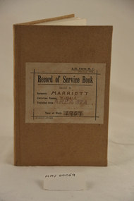
Booklet - Armed Forces, Australian Service book 1921, 1919
'Instructions " This book serves as proof of the fact that the bearer has performed the services required to fit him for the defence of his country, as prescribed by the (Defence) Act 1903-1918." 'Wilfred Marriott was from a family of early settlers in Moorabbin Shire. Wilfred (Willie) died at the age of 14 on 31 July 1921.The 'Record of Service Book' of Wilfred Marriott, b. 30/4/1907, of Jasper Road, Bentleigh, issued on 3/2/1921 in Area 37A Caulfield AM Form M7 / (revised 1919) / Record of Service Book / issued to / Surname MARRIOTT / Christian Names Wilfred / Training Area AREA 37A / Year of Birth 1907marriott wilfred, marriott geoff, australian military forces, defence act 1903, militia forces, record of service, caulfield, melbourne, moorabbin, bentleigh, world war 1914 -1918, world war 1939-1945 -
Glenelg Shire Council Cultural Collection
Photograph - Photograph - Portland Harbour Development, n.d
Port of Portland Authority ArchivesFront: Black & white Photograph of a plan showing proposed changes to the Fisherman's Breakwater area of the Port of Portlandport of portland archives, port of portland -
 Warrnambool and District Historical Society Inc.
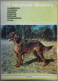
Book, Telephone Diretory 1974, 1974
The telephone directory contains both White Pages and Pink Pages listings. The White Pages listings are in alphabetical order of names for the entire 055 district. This directory is of some importance as it lists the names and addresses of people and businesses with telephones in 1974 in the 055 area code. Most of the listings of the smaller towns give the names of the homes and properties. So this is a very useful tool for research purposes.This is a soft cover booklet with a green cover and a colour photograph of an Irish Setter dog on the front cover and a map of the telephone area on the back cover. Front cover – ’74 Telephone Directory, Camperdown, Casterton, Edenhope, Hamilton, Portland, Warrnambool districts. STD area code 055. See back cover for area covered by this directory Spine – Camperdown, Casterton, Edenhope, Hamilton, Portland, Warrnambool districts. See the pink pages for business & trade listings. V1- 1974 Back Cover – Country directory areas. The area covered by this Directory is the coloured portion of this map. See the pink pages for business and trade listings. warrnambool 1974, warrnambool telephone directory 1974, 055 telephone directory -
 Bendigo Military Museum
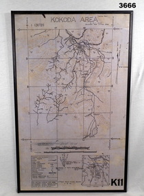
Map - MAP, KOKODA MOUNTED, 2nd Aust Field Survey Section, 4.9.1942
Map was compiled from aerial photos without ground control or inspection & with information received from Major CAMERON.Laminated map of Kokoda area on board backing with black border. Black printing on cream / fawn background. White hanging strap on back. Information ledger bottom LHS. Kokoda inset bottom RHS.Printed at top: “KOKODA AREA” Printed at bottom “RHS: K11”map, kokoda, mounted -
 Greensborough Historical Society
Photograph - Digital image, Charles Marshall et al, 3rd Light Horse Brigade watering area at Shellal, Palestine, 1917_
3rd Light Horse Brigade watering area at Shellal, PalestineDigital copy of black and white photograph"3rd Brigade watering area Shellal Palestine"charles marshall, world war 1 -
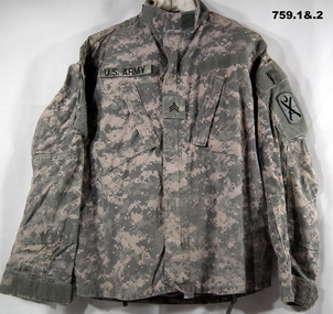 Bendigo Military Museum
Uniform - UNIFORMS CAMOUFLAGE
The uniforms belonged to Shai NOKES Australian Army Afghanistan. “DP”, meaning Desert Pattern..1) US Army Shirt grey camouflage colours, has four velcro areas for patches, central patch has 3 stripes, arm patch has a half crescent and crossed swords. .2) US Army pants grey camouflage colours .3) Australian Army Camouflage shirt DP. .4) Australian Army Camouflage pants DP.1) velcro areas, “US Army”uniforms, us army, camouflage, desert pattern