Showing 70 items
matching bacchus marsh roads and streets
-
 Bacchus Marsh & District Historical Society
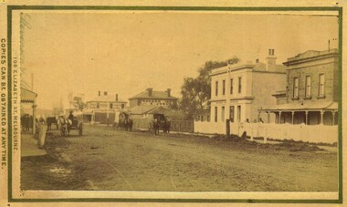
Photograph, Main Street Bacchus Marsh 1883 looking east
... Bacchus Marsh Roads and Streets... of Bacchus Marsh and District Bacchus Marsh Roads and Streets Bacchus ...View of Main Street Bacchus Marsh 1883, showing early notable buildings on the southern side of the street, including the Courthouse, National Bank of Australasia, Border Inn, Hall of Commerce building. Small sepia unframed photograph on card with gold border framing photograph. Housed in the album, 'Photographs of Bacchus Marsh and District in 1883 by Stevenson and McNicoll'. Several horse-drawn vehicles can be seen travelling along an unmade road. Piles of excavated dirt can be seen along the side of the road. Four substantial two-storeyed buildings can be seen along the southern side of the street.On the front: Stevenson & McNicoll. Photo. 108 Elizabeth St. Melbourne. COPIES CAN BE OBTAINED AT ANY TIME. On the back: LIGHT & TRUTH inscribed on a banner surmounted by a representation of the rising sun. Copies of this Portrait can be had at any time by sending the Name and Post Office Money Order or Stamps for the amount of order to STEVENSON & McNICOLL LATE BENSON & STEVENSON, Photographers. 108 Elizabeth Street, MELBOURNE. stevenson and mcnicoll 1883 photographs of bacchus marsh and district, bacchus marsh roads and streets, bacchus marsh main street 19th century -
 Bacchus Marsh & District Historical Society
Map, Maddingley Township, Parish of Parwan, circa 1890s
Maddingley is a locality or township within the broader township area of Bacchus Marsh. This map is not dated. However features in Maddingley which appeared in the 1880s and 1890s are present in the map, These include the Bacchus Marsh Railway Station and the Bacchus Marsh Showgrounds. The main residential and commercial area of Maddingley is shown on this map in an area bounded by Bacchus Street, Barry Street, Griffith Street and Maddingley Road. Other streets visible are Franklin Street, Inglis Street, Labilliere Street, McCrae Street, Moore Street and part of Station Street.A single page paper map showing land allotments, streets, rivers, creeks, park lands, the railway line and Bacchus Marsh railway station in the township of Maddingley. The map is pasted into a bound volume containing 76 maps or plans in total. bacchus marsh victoria maps, maddingley victoria maps, land use, maddingley victoria history -
 Bacchus Marsh & District Historical Society
Map, 'Map of Darley' circa 1877-1897
This map shows the early laid out streets and roads for the village of Darley and the main roads and streets in the central area of the township of Bacchus Marsh. The date of the map is not known. Landmarks indicated on the map including the Anglican Church in Church Street (Gisborne Road), opposite the Presbyterian Church, and the Baptist Church at its pre-1898 Main Street location suggest the map is dated between 1877 and 1897. Landholders names can be seen on some of the allotments of land marked in this map, including the names Clifton, Cosgrove, O'Hagan, McFarlane, Nagle, O'Hagan, Simpson and Vallence.A single page paper map showing the village of Darley and the township of Bacchus Marsh. Scale 10 chains to 1 inch. The map is pasted into a bound volume containing 76 maps or plans in total. High resolution digital image stored on BMDHS computer network. darley victoria maps, bacchus marsh victoria maps -
![Map, Ballarat and Gordons Lane Plan of Land required [for railway line work]](/media/collectors/5e461d8021ea67224c82f2a1/items/676ff3a62c3783fe00b96a8d/item-media/676ff4a42c3783fe00b96cb6/item-fit-380x285.jpg) Bacchus Marsh & District Historical Society
Bacchus Marsh & District Historical SocietyMap, Ballarat and Gordons Lane Plan of Land required [for railway line work]
The railway line from Melbourne to Bacchus Marsh was completed in February 1887. After this date work continued to extend the line to Ballan. This map indicates a portion of land only a few hundred metres west of the Bacchus Marsh railway station which would have been among the first stages of the line to Ballan to have been constructed. This suggests the date of this map to be in the late 1880s.Single page map showing land required for railway line work near Griffith Street, Bacchus Marsh. Scale 10 chains to 1 inch. Hand-written on the map are the exact distances between Bacchus Marsh and Gordons (Gordon) and between Bacchus Marsh and Melbourne as measured from the corner of Maddingley Road and Station Street. Distances recorded are in miles, chains and links. The land required for the railway works is marked in red ink and runs through an area known as Kennedy's Gully. Part of a set of maps which are pasted into a bound volume containing 76 maps or plans in total. High resolution digital image stored on BMDHS computer network. bacchus marsh victoria history, maddingley victoria history, railway lines -
![Map, [Plan for road to give J. Allan access to permanent water at Coimadai] circa 1870s](/media/collectors/5e461d8021ea67224c82f2a1/items/67735190d671e67dd573a84c/item-media/6773533dd671e67dd573cd90/item-fit-380x285.jpg) Bacchus Marsh & District Historical Society
Bacchus Marsh & District Historical SocietyMap, [Plan for road to give J. Allan access to permanent water at Coimadai] circa 1870s
... Coimadai Roads and Streets ...The date of this map or plan is uncertain but it appears to be from the early to mid 1870s. One of the landholders identified on the plan, James Allan of Coimadai died suddenly on the 9th July, 1874 (see Bacchus Marsh Express, 11 July, 1874, page. 3). There are mentions of an Allans Road at Coimadai in the Bacchus Marsh Express between 1887 and 1942.Single page map showing an excision of land belonging to Charles Ross which was selected to construct a road to give another landholder, J. Allan access to permanent water. Scale 1 chain to 1 inch. Part of a set of maps which are pasted into a bound volume containing 76 maps or plans in total. High resolution digital image stored on BMDHS computer network. Plan showing Excisions from Ross's selection and 1 chain road thro' the said selection in Coimadai to give J. Allan access to permanent water. Alistair ?? Shire Eng? 6?/5/7?coimadai victoria maps, coimadai roads and streets -
 Bacchus Marsh & District Historical Society
Map, Rough plan showing proposed deviation of road through McKenzie's Flat
... Bacchus Marsh Roads and Streets... Bacchus Marsh Roads and Streets Single page map showing a proposed ...The date of this map or plan is uncertain. McKenzie's Flat is a bushland picnic area on the Lerderderg River in the Lerderderg State Park close to Bacchus Marsh. Single page map showing a proposed deviation of the road near the McKenzie's Flat area close to Bacchus Marsh. The proposed deviation is shaded in pink, The existing road section to be replaced is shaded in blue. No scale is indicated. Part of a set of maps which are pasted into a bound volume containing 76 maps or plans in total. High resolution digital image stored on BMDHS computer network. mckenzies flat bacchus marsh, bacchus marsh roads and streets -
![Map, Millbank Estate Bacchus Marsh Thursday 4th October 1888 [Land sales], 1924](/media/collectors/5e461d8021ea67224c82f2a1/items/67765662eb6d2cbd24e0797f/item-media/67765682eb6d2cbd24e07a41/item-fit-380x285.jpg) Bacchus Marsh & District Historical Society
Bacchus Marsh & District Historical SocietyMap, Millbank Estate Bacchus Marsh Thursday 4th October 1888 [Land sales], 1924
The Millbank Estate was a parcel of land close to the centre of the shopping area of Bacchus Marsh which was sub-divided and offered for sale in 62? lots on the 4th October 1888. The lots had frontages to Ballarat Road (Main Street), Maddingley Road (now Grant Street), Turner Street, Millbank Street, Clarinda Road (now Clarinda Street), and an unnamed street south of Turner Street (possibly known as Grant Street at this time) which connected to Maddingley Road through the vicinity of the present day Bacchus Marsh Hospital. This was a significant sub-division of land and represented a major expansion of residential housing in Bacchus Marsh in the late 19th century. The map includes a wealth of detail about the time of the sale, where it will take place, who the selling agents were, the deposit terms for purchases and details of a special train from Melbourne to Bacchus Marsh on sale day. The location of the allotments in relation to the shopping and commercial area of Bacchus Marsh, Maddingley and the railway station are indicated on an inset map within the overall map and poster. The Millbank Estate area was an area which had once belonged to the Grant family who were prominent early citizens of Bacchus Marsh and lived in a house in this area known as 'Millbank'.This land sale map is a typical example of housing estate land sales advertising maps produced by real estate agents in this era. The map is significant for the detailed information it provides about when and where land was sold for new housing estates in Bacchus Marsh in the late nineteenth century.Single page map showing land allotments for sale at auction in Bacchus Marsh in October 1888. A significant portion of the map is missing from the bottom right side. land sales bacchus marsh, land subdivsion bacchus marsh, housing estates land sales bacchus marsh, grant family bacchus marsh, millbank estate land sales -
 Bacchus Marsh & District Historical Society
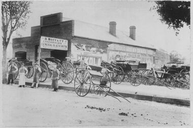
Photograph, H.Moffatt Coachbuilder General Blacksmith Main Street Bacchus Marsh
H. Moffatt, blacksmith, opened new brick premises in 1899 on the site of a similar building burnt down the previous year. He continued to operate as a coachbuilder and blacksmith on this site until 1927 when he retired. Since then, the premises have been used for coffin making, a hardware store, furniture store, bathroom supplies among other things. It is now operating as Lola's Restaurant.Black and white photographic print. Dating from the early 1900s, this photograph is of a substantial brick building opened in 1899 by Mr H. Moffatt at 110 Main Street on the site of a similar building which burnt down in 1898. A sign at the front reads: H.MOFFATT COACHBUILDER GENERAL BLACKSMITH. A number of horse-drawn carriages, two and four-wheeled, stand on the footpath, roadway and on the vacant block next door. The road appears to be unmade and is separated from the elevated footpath by barge boards. Advertising signs line the side wall of the building. Four men stand on the road, three wearing the leather apron worn by blacksmiths, one wearing a long white apron as was often worn by shop assistants. Horse droppings, a common sight in those days, can be seen on the roadway. shops bacchus marsh vic., main street bacchus marsh vic., h. moffatt, coachbuilders, general blacksmiths -
 Bacchus Marsh & District Historical Society
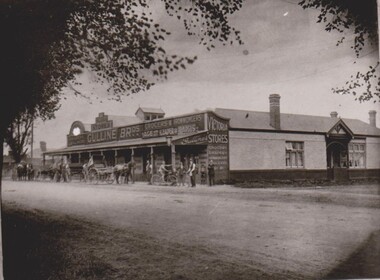
Photograph, Gulline Brothers Store, Grant Street Bacchus Marsh looking North towards Main Street, circa 1920s
... Roads and Streets Bacchus Marsh Vic.... survives in Bacchus Marsh. Roads and Streets Bacchus Marsh Vic ...Gulline Brothers was a general store in Bacchus Marsh located in Grant Street, on the corner of Grant Street and Sydney Street. The store was originally opened by John Jory in about 1890. At that time it was advertised as being located on Maddingley Road. It was later taken over by Horace Hussey and William Grant Morton trading as Hussey and Morton, and later solely as Morton's. In the early 1920s it was sold to the Gulline Brothers and traded under this name for many years. The building has had multiple uses and occupants since the Gulline Brothers ran their business there. The building is still standing today (2024) and is shared by three different businesses.An image of a significant late nineteenth century commercial building which still survives in Bacchus Marsh.Black and white photographic printroads and streets bacchus marsh vic., maddingley road bacchus marsh vic., grant street bacchus marsh vic., shops bacchus marsh vic., gulline brothers general store bacchus marsh vic., general stores bacchus marsh vic. -
 Bacchus Marsh & District Historical Society
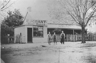
Photograph, C.J. Grant, Bootmaker's Shop, corner of Grant Street and Waddell Street, Bacchus Marsh, circa 1907-1909
Charles Grant opened a boot makers business on the northern corner of Grant Street and Waddell Street in 1907. The business was advertised as being in Maddingley Road. By early 1910 the business had moved to 'Ryan's Corner' on the corner of Main Street and Gell Street, Bacchus Marsh. The brick house behind the boot maker's shop was built for Alexander Murdoch in 1869. It was used as a residence, a boarding house and as part of a business by a number of different owners over many years. It was known as the Murdoch house and also as 'Links Cottage' when it was used as a boarding house. For most of the twentieth century it was used as a residence. It was demolished in 1997 to make way for new residences.Black and white photograph print. A reproduction of an original photograph which is mounted on board. The image shows a boot maker's business and a brick house behind it. Standing in front of the shop on the footpath are three men wearing aprons.boot makers bacchus marsh victoria, shops bacchus marsh, houses bacchus marsh