Showing 64 items matching "ballaarat old cemetery"
-
 Old Colonists' Association of Ballarat Inc.
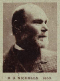
Photograph - Portrait, Robert U. Nicholls
Robert Uriah Nicholls was born in Devonshire, England, and arrived in Victoria in 1853, and Ballarat in 1854.] He ran R.U. Nicholls & Co., nurserymen in Doveton Street North, Ballarat. He was a member of the Ballarat Horticultural Society for 51 years, and was President of the Old Colonists' Association in 1907. Robert Nicholls died in 1910, and is buried at the Ballaarat New Cemetery.Photographic portrait of R.U. Nicholls who arrived in Australia in 1853.r.u. nicholls, robert nicholls, nursery, plant nursury, ballarat hortucultual society, robert u. nicholls -
 Old Colonists' Association of Ballarat Inc.
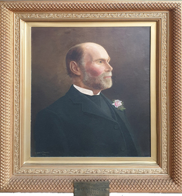
Painting - Image, T. Stanton Bowman, R.U. Nicholls, c1907
... in 1910, and is buried at the Ballaarat New Cemetery. old ...Robert Uriah Nicholls was born in Devonshire, England, and arrived in Victoria in 1853 on the Banker's Daughter, and Ballarat in 1854. He ran R.U. Nicholls & Co., nurserymen in Doveton Street North, Ballarat. He was a member of the Ballarat Horticultural Society for 51 years, and was President of the Old Colonists' Association in 1907. Robert Nicholls died in 1910, and is buried at the Ballaarat New Cemetery.Portrait of R.U. Nicholls, President of the Old Colonists' Association in 1907old colonists' association ballarat, stanton bowman, t. stanton bowman, r.u. nicholls, robert uriah nicholls -
 Federation University Historical Collection
Map - Geological Survey, J. Phillips, Geological Survey of Victoria - Ballarat, 1857, 10/1858
Geological map of the Ballarat District featuring four colours.ballarat, geological, geology, geological plan, main road, camp, golden point, pennyweight hill, clayton hill, ballaarat cemetery, bakery hill, specimen hill, soldiers hill, nightingale lead, native youth black hill flat, white flat, mining, mines, eureka lead, old post office hill -
 Federation University Historical Collection
Map, Ballaarat Gold Field, 1861, 21/10/1861
A party of surveyors camped by Yuille's Swamp (later Lake Wendouree) and surveyed the countryside for a map to be produced by the Geological Survey of Victoria. In November 2004 the Central Highlands Regional Library presented a special edition of 200 copies of the 1861 map reproduced from a copy in their collection. Original geological map of Ballarat showing property, waterways, mines, churches, schools, water races, and garden reserves. It was compiled and drawn from the surveys of Mining Surveyors Davidson, Fitzpatrick and Cowan.Compiled & Drawn from the Survey of Mining Surveyors Davidson, Fitzpatrick and Cowan & the Plans in the Surveyor General's Office by J. Brahe, 21st October 1861. R. Brough Smyth, Secretary for Mines. The Honourable J.B. Humffray, M.L.A. Commr of Mines.ballarat, map, davidson, robert brough-smyth, fitzpatrick, cowan, yuille's swamp, public garden reserve, manure depot, black hill, ballarat east, old post office hill, pennyweight hill, claytons hill, golden point, mining, railway, cricket ground, swamp creek, cemetery, sludge reserve, bakery hill, gaelic church, juvenile reformatory, orphanage, specimen hill, eureka lead, cattle yard hill, dalton's flat, chinese village, poverty hill, railway reserve, little bendigo diggings, pound reserve, allied armies, flour mill, agricultural reserve, marsh, survey reserve, survey corps, white flat, yarrowee, yarrowee creek, brache, j. brache, survey, ballaarat gold field 1861