Showing 203 items
matching beechworth roads
-
 The Beechworth Burke Museum
Photograph, 1960s
This photograph was taken in the 1960s at Lake Sambell Caravan Park and visible in the photograph are individual caravan sites with electricity outlets, a large single-story building with a caravan park banner, dirt roads, a freestanding message board, and a parked car. Lake Sambell Caravan Park opened in 1959 owing to the work of R.E. Carter, Beechworth Shire engineer from 1954-63. Carter advocated for improvements to the lake and surrounding area in order to encourage tourism in Beechworth. The opening of the caravan park was part of many improvements to Lake Sambell made in this period by Carter including: the swimming pool in 1961, water skiing and boating facilities, and increased lake surface in 1964. These improvements were financed mainly by grants from the Tourist Development Authority. The popularity of caravanning in Australia exploded during this post-war period of the late 1950s and 1960s. This popularity was driven by multiple factors, including: the stopping of fuel rations, the accessibility of car ownership through the manufacturing of affordable cars, technological developments in caravan design, and the increase in prosperity and leisure time for many Australians. Facilities such as electrical outlets to power caravans are present in this photograph of Lake Sambell Caravan Park. Lake Sambell is an artificial lake that was developed on the previous site of the Rocky Mountain Mining Company workings and was officially opened by Minister for Lands, Mr Baily, on October 5, 1928. The disused and unattractive remains of the mine were converted into a recreational area intended for swimming, boating, and fishing. The lake is named after Mr L.H. Sambell, shire engineer and secretary of the Forward Beechworth Committee, who advocated for the enhancement of Beechworth into a tourist destination and was central to the planning and establishment of the lake. This photograph is of historical and social significance in providing insight into caravanning during the 1960s in Australia. Caravanning was extremely popular during the 1960s in Australia due to multiple social and economic factors including the stopping of fuel rations, the accessibility of car ownership through the manufacturing of affordable cars, technological developments in caravan design, and the increase in prosperity and leisure time for many Australians.Black and white rectangle photograph printed on photographic paper and unmounted.Reverse: 3536/ [logo back printing: KODAK/ VELOX/ PAPER] / C798 lake sambell caravan park, lake sambell, caravanning 1960s, caravan park, rocky mountain mining company, kodak velox paper, r.e. carter, l.h. sambell, caravan electricity outlets, tourist development authority, post-war prosperity, forward beechworth committee, lake sambell boating, lake sambell swimming pool, lake sambell fishing, artificial lake, travel 1960s, recreation 1960s -
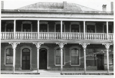 The Beechworth Burke Museum
Photograph - Two Photographs, Saunders, 1864-1972
Taken some time after 1864, these photographs depict the Star Hotel both directly (8674.1) and from the Hotel north west down Ford Street (8674.2). The images depict the building with its modern exterior, having settled for this brick form after several other building designs. The Star Hotel was the first hotel opened in Beechworth, and would go through a series of dramatic changes under its first three owners. The original timber structure was built by W.H. Neuber, though at the time it was only known as ‘The Beechworth Hotel’. The site was later purchased in 1855 by mining entrepreneur, and prolific business owner, John Alston “Six Stars” Wallace. He would go on to extend the established hotel, rebuilding much of it with weatherboard and a shingled roof, adding a two storey structure with a verandah and a theatre capable of supporting 400-500 people, which was often used for international performances. Renamed as the Star Hotel, it was the second in a chain franchise, eventually leading to the “Six Stars” moniker Wallace went by, with hotels at Rutherglen, Chiltern, Yackandandah, Bright, Snake Valley, and of course, Beechworth. Under his ownership, it developed into a popular location for merchants, wayfarers, and locals alike, with the help of his brother Peter as manager. Situated on a road once synonymous with Melbourne to Sydney roadtrips, and the allure of the gold mines, the popularity of the Star drew all manner of clientele from across the country. As such a central hub, the ‘Star Assembly Rooms’ were used as a meeting place for debates, discussions, festivities, and problem solving among the various working sects of the area. These meetings included shareholder discussions for prospecting companies, railway planning, council meetings, and discussions surrounding the interactions between European and Chinese miners, both good and bad. By late 1856, John had the Beechworth at auction through J.H. Grey & Co. It was most likely due to the high profile murder of the manager, Robert Murdoch, during an altercation in relation to a dine and dash event by a Swedish miner, Charles Jansen, who had been ‘excited by drink’ on November 17th. He had refused to pay for his meal and waiter James Mitchell failed to persuade him otherwise. Mitchell, or possibly Murdoch himself, forced him out as tempers and threats escalated. As the photos tell, there are a number of doors which may be entered through, and Jansen used an alternate entrance to access the building. Murdoch was investigating the noise when he encountered the furious man. He was subsequently stabbed with no warning by a small clasp knife, as he tried to stop the intrusion. His exclamations, "I’m stabbed, I’m stabbed!” alerting other occupants, and Jansen was restrained and arrested. Murdoch died the next day from his injuries, with the inquest carried out on the theatre stage. Some 3000 members of the town attended the funeral, and the Star hung black cloth in memory of Robert and his death. Afterwards, an auction caw the property pass to Messrs Robertson and Quirk, though would return shortly thereafter to Six Stars’ portfolio. Six Stars would later sell off his properties from 1862, with the Beechworth Star purchased by 1864 by John Sitch Clark. This allowed Clark to redevelop a significant portion of the Hotel, stripping a central section and constructing the brick structure that survives today, reopening the Star in July that year. It was after this time that our photographs were taken. Clark would later sell the property to Frank Mitchell, shortly before his own death. The next owner, Frederick Allen, lived on the property before the deed was sold to him in the 1880s. He would later sell the property to William Carroll in 1890, with proprietorship eventually moving to Mr. W.H. Porter, and transferring to a Mr. Marendaz by 1913 and Mr. Holly in 1915. Licensing disputes would arise 1917 between Margaret Carroll and a Mrs. McDonald, before it became delicenced some years prior to 1935. It was around this year that the property was bought by Mr. W.J. Pemberton at the meagre price of £500, down from the £13,000 Six Stars originally auctioned it for. It served as a Youth Hostel for a period of time around 1972, and currently the building serves as a private accommodation on the second floor, with shops taking up the ground floor level.These photographs of the Beechworth Star Hotel as they depict a form of Beechworth's first hotel, and also the site of a high profile murder. Two black and white rectangular photographs printed on matte photographic paper.8674.1 (reverse) Beechworth/ 734/ Tanswell’s Hotel [crossed out]/? Old Star/ Hotel,/[small pencil scratching]/ Saunders/ BMM 8674.1 8674.2 (reverse) Beechworth/ 60%[circled]/ Old Star Hotel/Building etc.,/ 12 ½ cm/ 3"[circled, arrows extending horizontally to edges]/[arrows extending top to bottom mid-right of reverse]/ Saunders/ 734[circled]/ BMM 867.2,/ [thin scribbled bordering around top, right, and bottom edges]star hotel, beechworth hotel, john alston wallace, ja wallace, john sitch clark, frederick allen, robert murdoch, meeting place, tragedy, theatre, mining town -
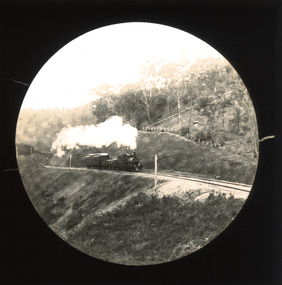 The Beechworth Burke Museum
Photograph - Lantern Slide, c1900
This slide shows a train proceeding along the Beechworth rail trail in approximately 1900. The rail line to Beechworth was the subject of significant lobbying by local officials such as John Orr and G.B. Kerferd in the 1860s, as it was recognised that the poor quality of roads to Melbourne and Albury hindered trade and formed a barrier to the social development of the town. The subsequent positioning of Beechworth on a branch rather than a main line was not considered ideal to achieve these aims, but the Everton-to-Beechworth and Beechworth-to-Yackandandah components of the line cost an average of £7,277 per mile and State Government officials felt the need in the area did not justify the cost of a direct line. The Beechworth Railway Station was officially opened on the 29th of September 1876 and ran services twice daily to Melbourne, transporting nearly 12,000 passengers and around 6,500 tons of cargo in 1900. It closed in 1976 and is today used as a cycling trail used by locals and promoted as a feature of the area to tourists. Lantern slides, sometimes called 'magic lantern' slides, are glass plates on which an image has been secured for the purpose of projection. Glass slides were etched or hand-painted for this purpose from the Eighteenth Century but the process became more popular and accessible to the public with the development of photographic-emulsion slides used with a 'Magic Lantern' device in the mid-Nineteenth Century. Photographic lantern slides comprise a double-negative emulsion layer (forming a positive image) between thin glass plates that are bound together. A number of processes existed to form and bind the emulsion layer to the base plate, including the albumen, wet plate collodion, gelatine dry plate and Woodburytype techniques. Lantern slides and magic lantern technologies are seen as foundational precursors to the development of modern photography and film-making techniques.This glass slide is significant because it provides insight into Beechworth's social amenities and transport infrastructure in the late Nineteenth Century. It is also an example of an early photographic and film-making technology in use in regional Victoria in the time period.Thin translucent sheet of glass with a circular image printed on the front and framed in a black backing. It is held together by metal strips to secure the edges of the slide.burke museum, beechworth, lantern slide, slide, glass slide, plate, burke museum collection, photograph, monochrome, indigo shire, north-east victoria, rail trail, beechworth rail trail, beechworth station, everton, wangaratta, wodonga, albury, rail transport, cargo transport, g.b. kerferd, john orr, murray to mountains rail trail, cycling, biking, railway -
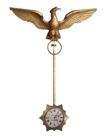 The Beechworth Burke Museum
Decorative object - Swinging Clock, Charles Frederick Falck, 1855
This clock was made by Charles Frederick Falck who was a watchmaker and jeweller in Beechworth from 1863-1908. Falck was born in Körlin, Prussia on May 22nd in 1833 and died at the age of 75 in 1908. Ovens and Murray Advertiser, Beechworth: edition June 13, 1908 OBITUARY: Falck was brought up to the business of watch-making, in which he developed exceptional mechanical ingenuity. Attracted by the favourable prospects held out by the Australian discoveries of gold he, like many other young adventurous spirits, left his native land to seek his fortune in the great southern Eldorado, arriving in Adelaide in 1854, and shortly after came to Melbourne where he worked as a journeyman, and subsequently started in business on his own account. Feeling inclined to test his fortune on the goldfields, he went to Blackwood but, meeting with little success, he returned to Melbourne where he was married. In 1862, he moved to Beechworth, where he commenced business as watchmaker and gold-buyer. He then embarked in vine-growing on the Sydney road, but eventually resumed his business avocations. His skill in practical horology was evinced in a clock of his own design and manufacture, surmounted by a golden eagle, which was exhibited at the first Melbourne Exhibition in 1856, and which afterwards formed a pre-eminent attraction in the window of his business premises in Ford Street. For many years, he filled the position of timekeeper to the Beechworth Racing Club, with complete satisfaction also at various sports meetings. He leaves a family of six sons and one daughter (Mrs. Jas. Broadfoot) all arrived at maturity. The funeral, which was well attended by a number of residents, took place at the Beechworth Cemetery on Sunday, the burial service being performed by the Ven. Archdeacon Potter. The cortege was capably supervised by Mr. D. Wilson, undertaker. The clock was returned to Beechworth in 2020 through the generous support of the Copland Foundation. Given that Mr. C. F. Falck traded as a watchmaker and jeweller in Beechworth for 45 years and traded with the 1855 clock mounted in his front window, there is a direct link between the clocks and the social, cultural and economic life of nineteenth century Beechworth at time when the town was developing and expanding in response to gold mining. This clock represent the significant skill and expertise of Charles Falck as an horologist. Medium-sized pendulum clock featuring a carved gilt wood eagle with wings outstretch (épandre - expanded with wing-tips directed upwards) and perched above a pendulum rod that holds a silver dial clock face within a reeded sunburst surround. The clock has an eight-day fuse movement with dead beat escapement wound from the clock face. C. F. F. FALCK / EXHIBITION 1856 / MELBOURNEburke museum, copland foundation, beechworth, leonard joel, auction, purchase, clock, pendulum, eagle, eagle clock, charles frederick falck, c. f. falck, falck, horology, pendulum clock, melbourne -
 The Beechworth Burke Museum
Decorative object - Swinging Clock, Charles Frederick Falck, 1870
This clock was made by Charles Frederick Falck who was a watchmaker and jeweller in Beechworth from 1863-1908. Falck was born in Körlin, Prussia on May 22nd in 1833 and died at the age of 75 in 1908. Ovens and Murray Advertiser, Beechworth: edition June 13, 1908 OBITUARY: Falck was brought up to the business of watch-making, in which he developed exceptional mechanical ingenuity. Attracted by the favourable prospects held out by the Australian discoveries of gold he, like many other young adventurous spirits, left his native land to seek his fortune in the great southern Eldorado, arriving in Adelaide in 1854, and shortly after came to Melbourne where he worked as a journeyman, and subsequently started in business on his own account. Feeling inclined to test his fortune on the goldfields, he went to Blackwood but, meeting with little success, he returned to Melbourne where he was married. In 1862, he moved to Beechworth, where he commenced business as watchmaker and gold-buyer. He then embarked in vine-growing on the Sydney road, but eventually resumed his business avocations. His skill in practical horology was evinced in a clock of his own design and manufacture, surmounted by a golden eagle, which was exhibited at the first Melbourne Exhibition in 1856, and which afterwards formed a pre-eminent attraction in the window of his business premises in Ford Street. For many years, he filled the position of timekeeper to the Beechworth Racing Club, with complete satisfaction also at various sports meetings. He leaves a family of six sons and one daughter (Mrs. Jas. Broadfoot) all arrived at maturity. The funeral, which was well attended by a number of residents, took place at the Beechworth Cemetery on Sunday, the burial service being performed by the Ven. Archdeacon Potter. The cortege was capably supervised by Mr. D. Wilson, undertaker. The clock was returned to Beechworth in 2020 through the generous support of the Copland Foundation and the Friends of the Burke. Given that Mr. C. F. Falck traded as a watchmaker and jeweller in Beechworth for 45 years and traded with the 1855 clock mounted in his front window, there is a direct link between the clocks and the social, cultural and economic life of nineteenth century Beechworth at time when the town was developing and expanding in response to gold mining. This clock represent the significant skill and expertise of Charles Falck as an horologist. Large swinging clock featuring a carved gilt wood eagle with its wings outstretched (abaisé - expanded with wing-tips lowered) and perched above a pendulum rod that holds a silvered dial clock face within a reeded sunburst surround. (Similar to #2019.056.01) The clock has an eight-day fuse movement with dead beat escapement wound from the clock face. C. F. FALCK / WATCHMAKERburke museum, copland foundation, beechworth, leonard joel, auction, purchase, clock, pendulum, eagle, eagle clock, charles frederick falck, c. f. falck, falck, horology, pendulum clock, melbourne -
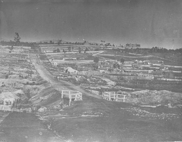
 The Beechworth Burke Museum
Photograph - Photograph - Reproduction, ca. 1900
This image shows the approach to Beechworth from the south-west via the Newtown Bridge. Numerous early buildings line the road as it bifurcates to become Ford and High Streets on the ridge above Spring Creek and Newtown Falls. The sloping, rocky terrain and water course along the gorge show evidence of the intense mining activity that occurred at the site. The Ovens Gold Rush at Beechworth started when gold was found at Spring Creek in February 1852, prompting an influx of miners from around the world. The population grew over 20,000 by 1857. While the earliest mining at Beechworth was similar to that in other Victorian goldfields like Ballarat and Bendigo, Beechworth is notable for its use of hydraulic sluicing as a major method of removing wash-dirt. Hydraulic sluicing employs high pressure jets of water to blast away large areas of earth and wash it down to be run through a sluice box. Gold gets caught in the sluice and the remaining slurry is washed away. This method of mining is extremely effective but causes significant environmental impacts and damage to waterways. Large water quantities were required for large-scale sluicing, and the long water races and deep tailraces that were constructed in the Beechworth area in the nineteenth century are nonetheless considered feats of engineering. The site in the photograph is associated with the Rocky Mountain Mining Company who constructed an eight hundred meter tunnel under the township between 1876-1880 to reduce water levels at Spring Creek, which had been subject to diversions since the earliest days of alluvial mining. Over four million ounces of gold (115 tones) were found at Beechworth between 1852 and 1868, and the wealth from the gold rushes built Beechworth and the nationally significant buildings that remain standing today.This image shows the early development of the Beechworth township above Spring Creek, where gold was discovered in 1852. Evidence of hydraulic sluicing, a uniquely predominant method at Beechworth, and water-works engineering are present in the landscape. By the 1870s, alluvial gold deposits were depleted and increasingly complex engineering was required so deeper shafts could reach bedrock. This image is significant for understanding changes to the landscape and the evolution of mining methods and engineering practices related to the extensive construction, manipulation and management of water networks. The shift from smaller scale alluvial mining to larger company dominance in the mining industry has implications for understanding wider social, economic, political and industrial changes in the region of Beechworth and within the context of the Victorian Gold Rush more broadly. A black and white rectangular reproduction photograph printed on photographic paper. burke museum, beechworth museum, beechworth, gold fields, gold rush, victorian gold rush, hydraulic sluicing, rocky mountain mining company, spring creek, netwown falls, mining tunnels, water races, tailraces, colonial australia, australian gold rushes, mining technology, beechworth historic district, indigo gold trail, migration, indigo shire, gold mining, gold mining history -
 The Beechworth Burke Museum
Photograph
Taken in Beechworth, this photograph depicts Albert road bisecting the Spring Creek Diggings.Black and white rectangular photograph. Image is printed on matte photographic paper and is mounted on cardboard.Reverse: 3292 (in pencil)beechworth, gold rush, spring creek diggings, albert road -
 The Beechworth Burke Museum
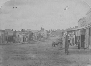
Photograph
Taken in Beechworth, this photograph depicts Ford street looking down the length of the shopping precinct. On the right of the road appears two figures and a horse and cart, in the distance appears a lone horse.Black and white rectangular photograph. Image is printed on matte photographic paper and is mounted on cardboard. Reverse: 7774 /beechworth, ford street, burke museum, shopping, horse -
 The Beechworth Burke Museum
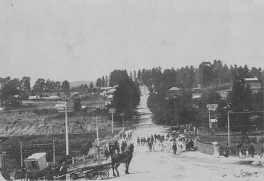
Photograph - Postcard, C early 1900's
... The Beechworth Burke Museum Loch Street Beechworth high ...Taken in Beechworth, this photograh depicts Camp Street and Albert Road looking towards Asylum Hill. In the center of the image, the railway gate appears to be closed. Black and white rectangular postcard. The image is printed on matte photographic paper and is mounted on cardboard. Obverse: NO INSCRIPTION Reverse: 7756 1997.2835 84-230-1 POSTCARD Beechworth with takers cart in foreground Townview . beechworth, camp street, albert road, asylum hill -
 The Beechworth Burke Museum
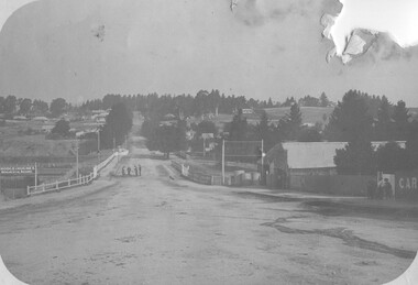
Photograph
... -country Taken in Beechworth, this photograph depicts Albert Road ...Taken in Beechworth, this photograph depicts Albert Road looking towards the Ovens and Murray Benevolent Asylum. In the center of the image are figures standing of a bridge. The Ovens Benevolent Asylum (or the Ovens and Murray Hospital for the Aged) was constructed in 1862 on an elevated site overlooking the township of Beechworth. This Asylum was built in response to boom in population due to the discovery of Gold in Beechworth in 1852. This period also saw the development of additional administration buildings such as; the Court house, the Town Hall, and offices. The original Benevolent Asylum building was designed in an unusual Flemish Gothic Revival style. The single storey building is of red brick on a dressed granite base, and the main facade is dominated by four curved, Flemish gable ends, those at the extremities being added to the original central section in 1867. This facade incorporates paired windows of pointed Gothic form and dark brick diaperwork patterning. The adjacent J. A. Wallace Wing of 1899 was designed by Donald Fiddes as a separate building. Also constructed of red brick, Fiddes adopted a conservative approach, designing a simple domestic scale building with central projecting gable porch and flanking bull nosed verandahs. The Benevolent Asylum was renamed the Ovens Benevolent Home in 1935 and The Ovens and Murray Home in 1954. Many buildings have been added to this site, particularly since the 1960s, including a poorly sited addition to the front of the original building. Extensive internal renovations have also been made to the original buildings. [https://vhd.heritagecouncil.vic.gov.au/places/118]Black and white rectangular photograph. The image is printed on matte photographic paper. Obverse: NO INSCRIPTION Reverse: BMM7590 1997.2848 AO2848 beechworth, albert road, benevolent, asylum, burke museum, photograph, black and white -
 The Beechworth Burke Museum
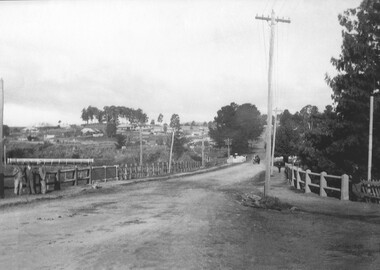
Photograph
... . beechworth albert road zwar tannery spring creek burke musuem ...Taken in Beechworth, this photograph was taken from Albert road with a view of the bridge over spring creek. In the foreground, there appears three brothers who worked for Zwar tannery.Black and white rectangular photograph. The image is printed on matte photographic paper. Obverse: NO INSCRIPTION Reverse: 7591 Albert Rd. Italian family, 3 brothers worked for the tannery Copied from the albums of Sergio Santori, Wangaratta. beechworth, albert road, zwar, tannery, spring creek, burke musuem, photograph, black and white -
 The Beechworth Burke Museum
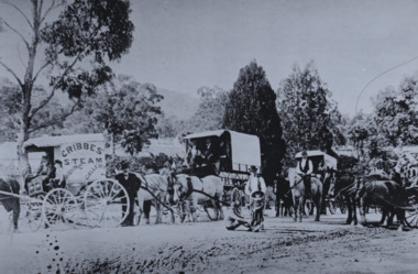
Photograph, c1890
Taken in the late 1800s, depicted is the Cribbes merry go round team lead by Alexander Cribbes, traveling along a dirt road. The merry go round team is spread out between 3 horse drawn wagons that each contain parts of the Cribbes merry go round. Along the sides of the road is a small group of onlookers made up of adults and children, while a horse drawn wagon gives way to the Cribbes procession.Black and white rectangular reproduced photograph printed on matte photographic paperReverse: 6958 (in pencil)/ 6958 (in blue pen)/entertainment album, burke museum, beechworth, entertainment, alexander cribbes, cribbes merry go round -
 The Beechworth Burke Museum
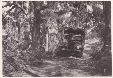
Photograph, 1944
Taken in 1944, the photograph depicts an Australian Army truck driving along an unsealed road from Stanley to the top of Mt. Stanley. A secret experimental micro-wave radio station was established and tested at Mt. Stanley by the Army Signal Detachment Unit during World War II. It was part of an experimental Ultra High Frequency (UHF) link between Melbourne and Sydney. At the time, it was highly classified. It intended to enquire into the hitherto unexplored transmission of micro-waves; that is, a radio signal which could only be transmitted by line of sight, and thus required hill-top to hill-top location.The photograph is historically significant as it pertains to World War II; the largest global conflict in history. This significance is enhanced by Australia's prominent involvement in campaigns across the Pacific, particularly on land in New Guinea and across the Huon Peninsula. It was also the first time that the Australian mainland came under direct attack by the Axis, with Japanese forces targeting north-west Australia and Sydney Harbour. These battles became Australia's largest and most complex offensives during the war. The record is also historically significant as it relates to the Royal Australian Corps of Signals, or "RA Sigs". This significance is strengthened by Australia's unique distinction of having the first established signal unit under the British Empire. This unit provides electronic warfare. They enable commanders to implement highly dynamic battle control against opposing forces by using a number of methods including radio, fibre optic, micro-wave, information systems and satellite links. The record has strong research potential. This is due to the ongoing scholarly and public interest in war, military history, the ANZAC legend, and the continuing existence of the RA Sigs. The historic context of this record can provide insight into Australia's history, military, technological innovation and advancements, as well as national economic, defence and foreign policies after 1945.Black and white rectangular photograph printed on matte photographic paper.Reverse: BMM5095.7 / The track up (?) from / Stanley to the top / 32 /military album, army album, military, war, wwii, world war ii, army signal detachment unit, royal australian corps of signals, beechworth, victoria, stanley, mt stanley, melbourne, sydney -
 The Beechworth Burke Museum
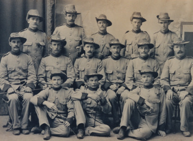
Photograph
It is believed that the photograph was taken between 1899 - 1903. Depicted is a group of fourteen unidentified young men dressed in Australian military uniforms. A few of them are holding swords. This group were part of the Beechworth Mounted Rifles; a voluntary detachment of the Australian Light Horse Militia. This unit consisted of soldiers from the Euroa, Longwood, Violet Town, Benalla, Thoona, Wangaratta, Rutherglen, and Beechworth Detachments of Victorian Rifles, and subsequently formed into the 8th Australian Light Horse Regiment (Victorian Mounted Rifles). The Victorian Mounted Rifles was gazetted as a volunteer formation on 2 December 1885 with the aim of consolidating all the disparate calvary units dispersed across Victoria into a coordinated and single administrative and military unit. Two contingents of the Victorian Mounted Rifles fought during the Second Boer War (11 October 1889 - 31 May 1902). This conflict was fought between the British Empire and two independent Boer states; the South African Republic and the Orange Free State, over the Empire's influence in South Africa.The photograph is historically significant due to its connection to the Second Boer War and Australian Light Horse Regiment. This significance is enhanced by Australia's involvement in this war, specifically of the Victorian Mounted Rifles. This unit retains a special significance within Victorian culture, as there is a memorial and monument - erected in 1903 - honouring their service on St. Kilda Road in Melbourne. The record has strong research potential. This is due to the ongoing scholarly and public interest in war, military history, and the ANZAC legend. The historic context of this record can provide insight into Australia's history, military and defence policies. Lastly, as the Victorian Mounted Rifles remain a largely unexplored topic in comparison to other military units and divisions, the record presents a unique opportunity for further and important study and research.Sepia rectangular photograph printed on matte photographic paper.Reverse: BMM2638 / 071 1NA211 22JAN98 FOTOSUPPLIES........ ........................................ /military album, beechworth mounted rifles, australian light horse militia, second boer war, victorian mounted rifles, australian light horse regiment, military, war, british empire, south africa, 1800s, 1900s, australian army -
 The Beechworth Burke Museum
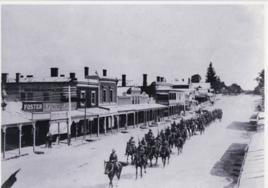
Photograph, 1908
Taken in 1908, the photograph depicts a long line of Australian soldiers riding atop horses. They marching down Ford St, Beechworth. This group were part of the Beechworth Mounted Rifles; a voluntary detachment of the Australian Light Horse Militia. This unit consisted of soldiers from the Euroa, Longwood, Violet Town, Benalla, Thoona, Wangaratta, Rutherglen, and Beechworth Detachments of Victorian Rifles, and subsequently formed into the 8th Australian Light Horse Regiment (Victorian Mounted Rifles). The Victorian Mounted Rifles was gazetted as a volunteer formation on 2 December 1885 with the aim of consolidating all the disparate calvary units dispersed across Victoria into a coordinated and single administrative and military unit. The Victorian Mounted Rifles fought in the Second Boer War (1889 - 1902), although it is unknown if the group depicted in this image were involved in the conflict.The photograph is historically significant due to its connection to the Australian Light Horse Regiment, specifically of the Victorian Mounted Rifles. This unit retains a special significance within Victorian culture, as there is a memorial and monument - erected in 1903 - honouring their service on St. Kilda Road in Melbourne. The record has strong research potential. This is due to the ongoing scholarly and public interest in war, military history, and the ANZAC legend. The historic context of this record can provide insight into Australia's history, military and defence policies. Lastly, as the Victorian Mounted Rifles remain a largely unexplored topic in comparison to other military units and divisions, the record presents a unique opportunity for further and important study and research.Black and white rectangular photograph printed on matte photographic paper.military album, military, war, wwi, world war i, beechworth, ford st, parade, horses, mounted rifles, soldiers, victorian mounted rifles, australian light horse militia -
 Warrnambool and District Historical Society Inc.
Boot, Tom Rome, Early 20th century
This boot belonged to Thomas Rome and may have been either an apprentice’s model or a display item in his boot and shoe shop or both. Thomas James Rome (1873-1974) worked in John Younger’s store in Beechworth before both came to Warrnambool in 1888. Rome worked in Younger’s store in Liebig Street, Warrnambool for 17 years and then established his own boot and shoe store at 115 Liebig Street in 1907, retiring in 1962. He married Amelia Saltau and they lived at Murweh at the corner of Liebig and Princess Streets, Warrnambool. Thomas Rome is mostly remembered today for his purchase and use of an Edison phonograph machine in the late 1890s and the sound recordings he made with this machine at the Warrnambool Industrial and Art Exhibition of 1896-7. These recordings were found intact after Rome’s death and are regarded as the earliest sound recordings still surviving in Australia today. This sample boot is of great significant as an example of the bootmaker’s art in the early 20th century and as a memento of Thomas Rome, important in Warrnambool’s history as a businessman and in the history of sound recording in Australia. This is a small sample black leather boot (probably a lady’s boot). It has double ridged stitching across the instep with a soft leather upper part and stitching separating the soft leather section from the smooth leather. The right side of the boot has seven button holes and seven buttons attached with metal clips. The sole is leather with a small heel and the name of the owner stamped on the sole. ‘10’ ‘T.J.Rome’ thomas rome, history of warrnambool, antique lady's boot, leather boot vintage -
 Warrnambool and District Historical Society Inc.
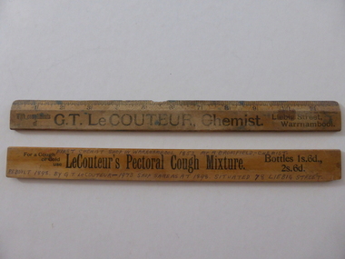
Ruler, G T Le Couteur Chemist x 2, Early 20th century
These rulers have been distributed by the Warrnambool chemist, George Le Couteur as advertising tools for his business. George Le Couteur operated a pharmacy at 78 Liebig Street, Warrnambool from 1896 to 1908. Born in Warrnambool in 1856 Le Couteur was educated at the Anglican-sponsored Warrnambool Common School No. 691 and then spent four years at Beechworth Grammar School. He was apprenticed to the Warrnambool chemist, Michael Ryan and then worked as a chemist in Kyneton and Melbourne. When he returned to Warrnambool he took over the business of Frank Uren in Liebig Street, building a second storey on to the building. He was very active in community affairs in Warrnambool. He left Warrnambool in 1908 to open a pharmacy in Hawthorn, Melbourne. When he retired in 1935 he was the oldest registered chemist in Victoria. The information hand printed on the back of one of the rulers has an historical inaccuracy in that J.A. Bromfield was not the first known chemist in Warrnambool. These rulers are of interest because of their connection to the pharmacy business of George Le Couteur He was a prominent person in Warrnambool in the 19th and early 20th centuries.These two oblong wooden rulers have imperial measurements ( to 12 inches). There is black printing on both sides advertising a Warrnambool chemist. One ruler is much stained and has a piece missing on the centre top edge. The other ruler has information on one side hand printed in black ink.‘With compliments of G.T. Le Couteur, Chemist, Liebig Street, Warrnambool’ ‘For a cough or cold use Le Couteur’s Pectoral Cough Mixture. Bottles 1s.6d., 2s.6d.’ ‘First Chemist Shop in Warrnambool 1853 Mr A. Bromfield – Chemist, rebuilt 1898 by G.T. Le Couteur – 1973 shop same as at 1898 situated 78 Liebig Street’ george le couteur, history of warrnambool -
 Kiewa Valley Historical Society
Photograph - 30 black and white photographs (assorted sizes) plus page from a newspaper and copied article on A4 paper, c1880's c1910 - 1920 (photographs) Newspaper 1961
K2,3 and4 are of the Kiewa River and two of the bridges spanning the river along the valley. K3 and K4 would have been taken in the 1880's and show the type of trees and plant growth along the river prior to land clearing for farming. K5 is of the Running Creek Cricket Team and therefore there was sufficient population in the area to form and maintain a team as well as have other teams in the relatively near vicinity to provide competition. Note the horse drawn cart which provided transport. Date taken is unknown but possibly c 1910. The Mt. Buffalo Chalet was built in 1910 by the Victorian Government. It was Australia's first ski resort and has served generations of skiiers, hikers and families over the years. It was built for 3195 pounds and has had stories and wings added since and is the largest timber building in Australia. B4 is the earliest photo in this group as the garden is in early stages of development - the other photos show the growth of the shrubs and would be taken about c 1920. Note the cars and motor bikes. It closed in 2006. The other photos are of general interest only but interesting to see that there were donkey's grazing. There is no information as to their purpose on Mt. Buffalo. Four different Kiewa Valley families are represented in the photographs. Their descendants still live in the Valley and carry on the traditions of beef and dairy farming. Of particular interest is the photo of Miss Marjorie Clemence, the first School Teacher of Upper Gundowring School. Gundowring pastoral run was taken up in 1838 and occupied by framers in the 1860's. The area was known as Gundowring and Upper Gundowring. The Gundowring School was opened in 1871 and most likely the Upper Gundowring school would be built at the same time. It was School No. 2733 and situated in Boyd Road. It closed in 1953 when the Kiewa Consolidated School opened. The newspaper page describes the activities in which the local community of Kergunyah were in engaged in that period - Red Cross, Fire Brigade, cattle round up and some of the identities involved. The article photocopied from the Yackandandah times states that he (Norman Coad) "was sent to the Ovens District Hospital, Beechworth for treatment" which would mean that this was the closest hospital to the Kiewa Valley for emergencies in 1912.The Kiewa Valley photographs are of social significance showing two of the early bridges allowing the community easy access to both sides of the river and also the tree and plant growth before land clearing for farming. The photos of Mt. Buffalo Chalet have social, architectural and historical significance. the Chalet has been used by skiers, bush walkers and day trippers since its completion in 1910 and its closure in 2006. It is listed in the Victorian Heritage Register. The family photographs are of social and historical significance as they are of early farming families in the Kiewa Valley and also depict the dress, of both men and women) in the late 1880's. The write up in the Weekly Times has social significance as it depicts the social and farming activities and photos of the local residents from around that area. The article from the Yackandandah Times is of a personal nature with concern for the individual involved. Note: There is a photo of the gentleman mentioned in the article (Mr. Norman Coad) in the Families of the Kiewa Valley (F4) as above.30 black and white photographs - 5 of the Kiewa Valley, 8 of families of the Kiewa Vallley and 17 of Mt. Buffalo. Various sized photos. Page from the Weekly times and copied article from the Yackandandah Times on A4 sheet.(Note for easier identification they have been numbered and grouped - K1-5 (Kiewa Valley), F1-8 (Families) and B1-17 (Mt. Buffalo). K1: handwritten in ink, lower L hand corner "Bogong in the distance". K2: handwritten in ink lower L hand corner "Mongan's Bridge or Towonga". K3 handwritten in ink "Taken from Mongan Bridge looking up stream". K4 - no inscription. K5: handwritten in ink, back of photo "Running Creek Cricket Team". F1: handwritten in ink on back "Mrs. Heap" and lower down in pencil "1880's". F2 handwritten in pencil at top of back phot "Land at Tawonga TROVE The Y'dah Times 20/2/1913" and lower down in ink "Henry Ellis Larkin". F3: handwritten in ink bottom edge "Mrs Coad". Note that this photo is a postcard. F4: Written in ink lower edge "Norman Coad". Note this photo is also a postcard. F5: Lower left corner in Ink "Harry Larkin". F6: lower half back of photo, in ink "Bernie Maddison". F7: on back of photograph in ink "Miss Marjorie Clemence first School Teacher Upper Gundowring: and underneath, in pencil "C1880's". F8: Handwritten in ink on back of photo "Frank & Mrs. Keat & Lesley of Tawonga". Lower down in pencil "c1912-1914". B1: Back of photo in ink "The Chalet Mt. Buffalo". B2: no inscription. B3: "chalet at Bufflo" in ink lower left corner. B4: This is a post card. Written in ink is "Mt. Buffalo Chalet". B5 - B10 printed in ink, lower left corner "Buffalo". B11: no inscription. B12: "Mt. Buffalo" lower R corner. B13: "Buffalo?". B15: Printed in ink lower edge "Picnic at Buffalo". B16: "Donkeys on Mt. Buffalo" printed in ink lower edge. B17: handwritten in ink across back of photo "Donkeys & top of Mt. Buffalo with the Monileith in the distance". A4 sheet of paper describing an accident to Mr. Norman Coad. Under article is : Yackandandah Times (Vic: 1890 - 1931), Thursday 18 July 1912, page 3. A page torn from the Weekly Times, June 14, 1961 and entitled "Kergunyah has picturesque setting". kiewa valley, farming, families, kergunyah, gundowring upper, mt. buffalo chalet, briggs family, larki family, coad family, clemence family, laskowski collection -
 Eltham District Historical Society Inc
Photograph, Fay Bridge, EDHS Heritage Excursion, Culla Hill, Sweeneys Lane, Eltham, 7 September 2019
September Excursion - Culla Hill Walk Pioneer Eltham farmer Thomas Sweeney (1803 - 1867) named his house, “Culla Hill” after the area in Ireland that he came from. His house, now called “Sweeneys”, remains on a ridge line overlooking the Yarra River. It is recorded that Thomas Sweeney did well out of carting potatoes and other supplies to the various gold fields such as Bendigo, McIvor (Heathcote), Mount Alexander and Beechworth. Culla Hill is now the name of the road providing access to subdivided lots of the former Sweeney property. The Culla Hill walk will start at the corner of Kent Hughes and Lavender Park Roads, Eltham (Melway ref. 22 A9) at 2.00pm on Saturday 7th September. - EDHS Newsletter No. 247 August 20192019-09-07, activities, culla hill, eltham, eltham district historical society, fay bridge collection, heritage excursion, sweeneys lane -
 Greensborough Historical Society
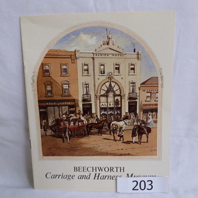
Booklet, Beechworth Carriage and Harness Museum, 1900c
Details contents of museum and describes the various types of carriages, tools and harnessesHistory of the manufacturing and maintenance of carriages12 page souvenir booklet, coloured front page, illustrated with a reproduction of an S.T Gill painting, black and white interiorcarriages, beechworth, beechworth carriage and harness museum, harness, buggy tools -
 Kiewa Valley Historical Society
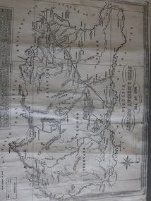
Map of the Ovens and Murray District of Victoria
The map features Beechworth and its history.This map features the north-east and in particular, Beechworth where residents of the Kiewa Valley may have shopped or visited for appointments.Black and white map with references to roads and gold. The centre of the map is Beechworth and in the bottom left side of the map is the heading Beechworth with 12 lines of print of information regarding Beechworth. The Kiewa Valley is not identified.beechworth -
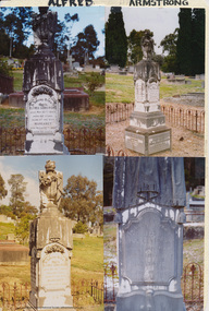 Eltham District Historical Society Inc
Folder, Armstrong
Alfred Armstrong Armstrong, Alfred, Eltham is a native of Somerset, England, born in 1825, and was employed under Mr. Mark Isambard Kingdom Brunel as a civil engineer prior to his coming out to Melbourne in 1852. He first visited Beechworth, but returning to Melbourne took contacts at Essendon and Gisbourne for forming and metalling the road. He afterwards purchased property at Eltham, where is at present mining, surveyor, inspector of mines, and mining registrar for the St Andrew’s division of the Castlemaine mining district. Mrs Armstrong, to whom he was married in 1854, at St Paul’s Church, Melbourne, died on 27th March, 1887. from "Victoria and its Metropolis: Past and Present" written in 1888 by Alexander Sutherland. Chapter 19, "The Upper Yarra District" pages [402] - 415. Includes descriptions of some townships and short biographies of local residents. Page 405 Folder of information on Alfred Armstrong, Eltham and Kangaroo Groundalfred armstrong, ada gertrude armstrong, arthur reynolds stockwood armstrong, arthur vivian harrison, eltham cemetery, gravestones, laura augusta harrison (nee armstrong), margaret armstrong, mary armstrong, thomas armstrong -
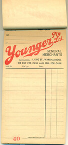 Warrnambool and District Historical Society Inc.
Document - Younger Pty Ltd docket book, 1950s
This booklet of sales dockets came from the Youngers Stores in Warrnambool. John Younger came to Warrnambool from Beechworth in 1888 and established a general store in Liebig Street and quickly built up a thriving business. His store was one of the main reasons why Liebig Street became the main shopping precinct in Warrnambool by the beginning of the 20th century. John Younger was active in community affairs and was a Town Councillor from 1902 to 1918 and Mayor of the Town. He died in the 1930s and his store was continued by family members but taken over by Charles Moore in 1958. It closed in the 1980s. The maker of the docket book, Lamson Paragon Limited, was a British firm with factories and offices in Australia and it initially specialized in making sales docket books using a carbon paper process. The original founder of the firm, William Lamson of Massachusetts, U.S.A., was the first to introduce the system of paying for goods in a store using cash balls on tracks. This pad is of some interest as it shows the system of receipts issued by a Warrnambool firm in the 1950s. It is of particular interest coming from Youngers Stores, a major retailer in Warrnambool for over 90 years. This is a pad of dockets stapled together 30 pages). The pages are buff-coloured with red and black printing on every second page. Every second page has been left blank so that a second copy could be kept of every transaction using carbon paper. The pad originally had dockets for 50 transactions for Youngers Stores in Liebig Street, Warrnambool. The first three pages are badly torn. The back of every docket has an advertisement for Youngers stores.Docket front: ‘Phone 21, Terms, Nett Cash, M……………., Younger Pty Ltd, General Merchants, Registered Office, Liebig St., Warrnambool, We Buy for Cash and Sell for Cash, Sold by, Exd. By, Date, Lamson Paragon Limited.’docket book, younger pty ltd, general merchants, department stores, liebig street, warrnambool -
 Ringwood and District Historical Society
Book, Collins Bros & Co Ltd, Cricket scoring book 1937 - 1938, 63 pages. Brown hard cover. Used for all matches involving Ringwood North Cricket Club. Includes summary of batting, bowling and other statistics, C. 1937
Used by Ringwood North for scoring cricket matches from 2-Oct-1937Cricket scoring book 1937 - 1938, 63 pp. Brown hard cover. Used for all matches involving Ringwood North. Includes summary of batting, bowling and other statistics. +Additional Keywords: McAlpin, MansonOn card. Presented as exhibit celebrating 50th anniversary of Manson McAlpin, Ringwood municipality. Now of Stanley via Beechworth 3747. -
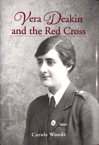 Ringwood and District Historical Society
Book, Royal Historical Society of Victoria, Vera Deakin and the Red Cross - Carole Woods, 2020
Hardcover book exploring Vera Deakin's national and international humanitarian activism and assisting several welfare groups, particularly the Red Cross.The centenary of World War 1 has focused attention on the 32,000 case files of the Australian enquiry bureau and given renewed redcognition to Vera Deakin's key role in the search for the missing. Carole Woods OAM is a Fellow and Honorary Secretary of the Royal HistoricalSociety of Victoria. A longtime advocate for community history, she chaired the judges' panel of the Victorian Community History Awards for seven years. Carole curated two major exhibitions at the RHSV related to the Australian Red Cross. Her books include Vision Fugitive: The Story of David Allen, and Beechworth: A Titan's Field. -
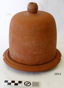 Flagstaff Hill Maritime Museum and Village
Domestic object - Terracotta Cooler Top, Ovens Pottery, c. 1890-1892
The Ovens pottery operated from 1881 to1892 they had taken over H L & E pottery at Beechworth in 1888 but mounting debts forced the Ovens company to close in 1892. During their short ten years of operation they produced stoneware garden urns, vases, cheese dishes, ginger beer bottles, butter coolers, water filters, wine and spirit barrels, bread plates, jugs, teapots, storage jars, pots, tiles, flower pots, spittoons, basins, bowls, demijohns, lidded crocks, pipes and bricks.A significant item made by an early Australian pottery in Beechworth Victoria, this company made many utilitarian items for the Victorian domestic market. It gives us today a snapshot into early Australian companies that were unable to sustain manufacturing their products into the 20th century, due in part to the rising imports of cheaper items from overseas.Red terracotta butter cooler comprising, round base with ridged lip, and bell shaped, domed lid with spherical handle on topMarked "Ovens Pottery, Co Ltd, Patd 1890, Beechworth" flagstaff hill, warrnambool, shipwrecked coast, flagstaff hill maritime museum, flagstaff hill maritime village, great ocean road, cooler, terracotta cooler, utensil, kitchen ware, terracotta, food container, food preservation, butter cooler, ovens pottery -
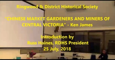 Ringwood and District Historical Society
Mixed media - Video, RDHS Guest Speaker Presentation - "Chinese Market Gardeners and Miners of Central Victoria" - Ken James
Digitised video (2.07GB) Duration: 50 minutes. Recorded July, 2023 (Video is available for viewing at Ringwood & District Historical Society Archives by appointment)Ken James is a prolific historical writer and is a regular to our Society's meetings. In this presentation, Ken talks about another book he is writing, involving the Chinese community in the small town of Lyal, between Castlemaine and Heathcote. In 1861, there were more than 24,000 Chinese immigrants on the goldfields of Ararat, Ballarat, Beechworth, Bendigo, Castlemaine and Maryborough. The Chinese were particularly industrious, with techniques that differed widely from the Europeans. This and their physical appearance and fear of the unknown led them to being persecuted in a racist way that would be regarded as untenable today. -
 Uniting Church Archives - Synod of Victoria
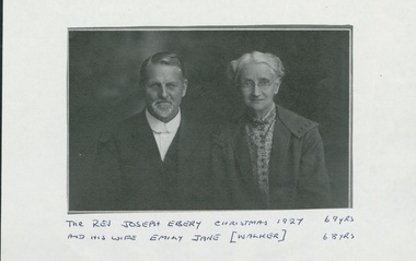
Photograph, Rev. Joseph Ebery and his wife Emily Jane (née Walker), Christmas 1927, 1927
Joseph Ebery was a Congregational minister, born 1858, died November 3, 1947. Ministry was as Wesleyan Home Missionary ?–1897; Congregational churches – Dover (Tas) 1897-1907; Tamar St Launceston 1907-1909; Devonport 1909-1914; Gatton (Qld) 1915-?; Redcliffe (Qld) 1921-1927; Beechworth (Vic) 1927-1930; Hughesdale 1930-1934. Was a Wesleyan lay preacher at Allandale and Woodbridge (Tas). Obituary - "… For ten years carried on an energetic evangelistic ministry, riding his horse over the roughtest roads in his scattered district, which was 25 miles long, and visiting even the southern-mosst home in the island (Tasmania)" As a Wesleyan Home Missionary he was not allowed to marry. The Congregationalists had no such restrictions so he joined the Congregational Church and married his Emily. [See Munster, Biographical Index of Congregational Ministers in Victoria 1838-1977.)Photocopy of studio portrait of Rev. Joseph Ebery and Mrs. Emily Jane (nee Walker) Ebery, Joseph aged 69 and Emily aged 68. Joseph, beard and moustache, is wearing a suit with a cellophane collar, no tie. Emily is earing a coat over a patterned shirt, and a choker necklace and glasses.As for the title.ebery, joseph, congregationalist, wesleyan home missionary, 1858-1947 -
 Uniting Church Archives - Synod of Victoria
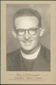
Photograph, Rev. C. G. Forward - Pastor 1937-1943, 1937-1943 - taken while at Black Rock Congregational Church
Born 3/4/1907 Launceston; died 10/10/1982 Adelaide. Attended Congregational College 1925-1930. Ordained Hughesdale 9/2/1931. Ministry: Hughesdale 1929-1931; Beechworth 1931-32; Gardiner 1932-37; Black Rock 1937-1942; Military Chaplain Aust & PNG 1942-45; Croydon/North Croydon 1945-51; College Park (SA) 1951-56; Luhrs Road Payneham/Hectorville (SA) 1956-60; Luhrs Road Payneham 1960-61; Colonel Light Gardens 1961-67; Port Elliott (SA) 1967-71. President Congregational Union of South Australia 1958-59. Married Madge (undated). Retired 1971. Further information - Portrait, SA Cong., February 1958, p. 4.Sepia photograph, mounted on light brown card of Charles Gilbert Forward wearing striped dark suit with clerical stock and collar, as well as glasses and a very light moustache.Rev. C. G. Forward - Pastor 1937-1943forward c. g., congregationalist, victoria, south australia congregational churches -
 Forests Commission Retired Personnel Association (FCRPA)
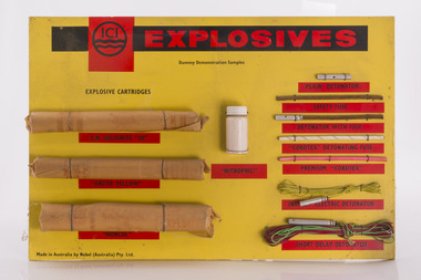
ICI Explosives Sampler
The Forests Commission had a large and active engineering branch which was often called upon for major demolition or quarry work. Most overseers, as well as some foresters, were trained in the use of explosives to “blow stuff up” such as removing stumps and rocks from roads. Districts usually had a small powder magazine tucked away in the bush for storage of gelignite and detonators.Sample board showing examples of explosives and detonatorsroad construction and maintenance.